fogphenomenaair qualityclimate sciencesky

Fog vs. Mist vs. Haze: Reading LA's Gray Skies

By WeatherLA|Published |Last updated |9 min read
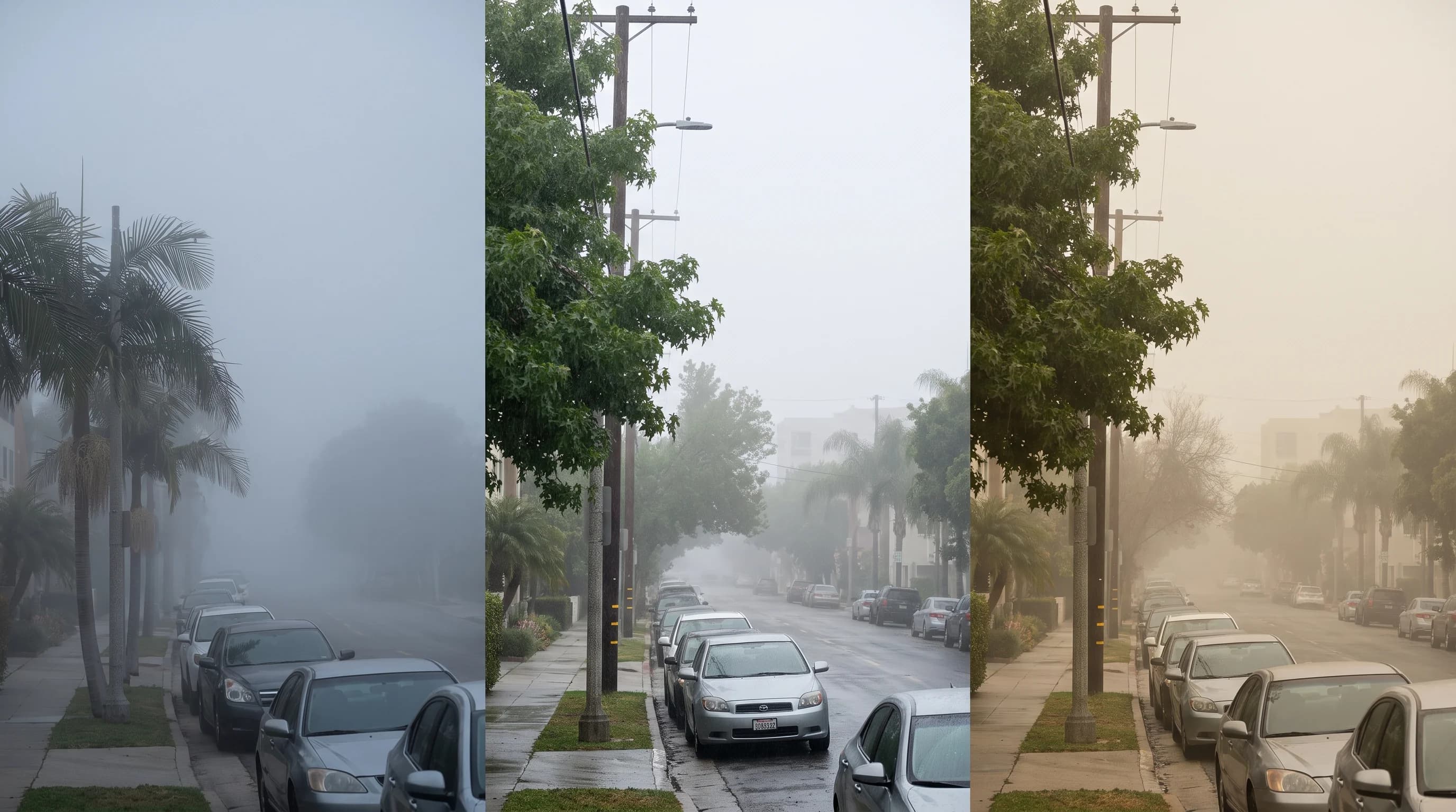
Three side-by-side Los Angeles overlook views showing dense coastal fog, light moist mist, and dry brownish haze from the same vantage point

Key Takeaways

  • Fog and mist are the same water-droplet process; fog cuts horizontal visibility below 1 kilometer (about 0.62 miles), while mist is the lighter version that leaves visibility at or above that mark.
  • Haze is a fundamentally different phenomenon: reduced visibility from dry particles like smog, dust, or smoke, and it can occur without high humidity.
  • Marine fog forms along the Southern California coast when cold, upwelled Pacific water chills a moist marine layer trapped beneath a temperature inversion, intensified by nighttime radiational cooling.
  • Low stratus cloud can sit above the ground without touching it, so it is not technically fog at the surface even though it looks identical from below.
  • Ozone-season haze typically builds through a sunny inland afternoon, while marine fog clears from the coast inward by late morning, a timing difference that helps separate the two.
  • Fog, haze, and smoke can occur in separate layers at the same time and place, so a single glance at a gray LA sky cannot reliably diagnose the cause; dew point spread, visibility, cloud base, and the dominant AQI pollutant can.

Fog and mist are both suspended water droplets, and the only real difference between them is density: fog cuts horizontal visibility below 1 kilometer (about 0.62 miles), while mist is the same process at a lighter concentration that leaves visibility at or above that threshold. Haze is a different phenomenon entirely. It is reduced visibility caused by dry particles, dust, smoke, or pollution suspended in the air rather than water. In Los Angeles, the gray sky over Downtown Los Angeles on a summer morning is almost always marine fog or mist off the Pacific, while a brownish tint over Woodland Hills on a still, hot afternoon is more likely haze from ozone and particulates.

What is the difference between fog, mist, and haze?

Fog and mist are the same physical thing, water droplets suspended near the ground, and the label that applies depends entirely on how far you can see through it. The National Weather Service Los Angeles/Oxnard office and the National Weather Service glossary define fog as a surface-based cloud of water droplets, or ice crystals in freezing conditions, that reduces horizontal visibility to less than 1 kilometer. Mist describes the identical droplet process at a lighter concentration, one that leaves visibility at 1 kilometer or beyond, so mist is best understood as fog that has not (or not yet) thickened enough to earn the stricter label.

Haze is a separate category. It is reduced visibility caused by dry, fine particles suspended in the atmosphere, including dust, smoke, sulfates, and the secondary particles and ground-level ozone produced by photochemical smog. Unlike fog and mist, haze does not require saturated air or high humidity to form. A hazy day in the San Fernando Valley can happen under a dry, sunny sky with humidity well below what fog needs, because the particles doing the scattering are dry aerosols and pollutants, not water droplets. That distinction (water versus dry particulate) is the fastest way to sort what is actually gray-ing out a Los Angeles skyline on any given morning.

Fog vs. Mist vs. Haze: How Los Angeles Skies Compare
TermWhat it's made ofVisibility thresholdTypical LA setting
FogSuspended water droplets (surface-based cloud)Below 1 km (about 0.62 miles)Coastal mornings at Downtown Los Angeles and along the shoreline, especially late spring through early summer
MistSame water droplets as fog, lighter concentrationAt or above 1 km, but still visibly gray or dampThinning edges of a marine layer, or fog that is forming or clearing
HazeDry particles: smog, dust, smoke, sulfatesVariable; tied to PM2.5 and ozone concentration, not humidityWarm, stagnant afternoons in inland basins like Pasadena and the San Fernando Valley

How do humidity and visibility help distinguish fog, mist, and haze?

Relative humidity near 100% is the single strongest clue that gray sky is fog or mist rather than haze, because water droplets only form and persist when the air is at or very close to saturation. Haze can occur across a much wider humidity range, since it depends on how many dry particles are suspended in the air, not on how close the air is to its dew point. Checking the dew point spread (the gap between air temperature and dew point) is a practical way to tell the two apart: a spread near zero points to fog or mist, while a wide spread with reduced visibility points toward haze, smoke, or dust.

Droplet size and horizontal visibility distance do the rest of the sorting. Fog droplets are large enough and dense enough to scatter light broadly and cut visibility sharply, often to a few hundred feet in the thickest coastal fog. Mist involves the same droplets at lower concentration, so visibility stays longer, typically past half a mile, while the air still feels damp and looks gray. It is worth noting that field observers, airport weather stations, and even NWS products do not always apply "mist" with perfect consistency. Some reports use "mist" for any light, damp obscuration regardless of the exact visibility number, so the visibility distance itself, not just the label on a forecast, is the more reliable data point to check.

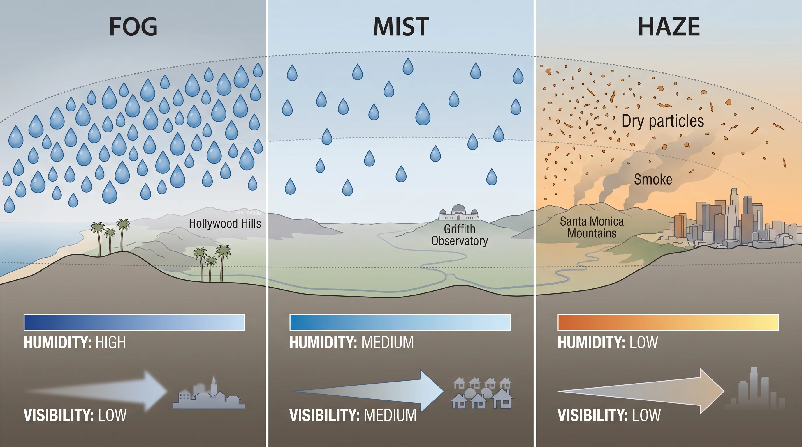
A particle-scale comparison illustration showing large, closely packed water droplets that make up fog, the same droplets more sparsely spaced to form mist, and fine dry pollution and smoke particles that make up haze, each paired with a labeled humidity range and visibility distance
Fog and mist are the same water-droplet process at different concentrations. Haze is a different mechanism entirely: dry particles that scatter light without requiring saturated air.

Why does marine fog form along the Southern California coast?

Marine fog forms because cold, upwelled water off the Southern California coast chills the moist air sitting just above it until that air reaches saturation and condenses into droplets. The Pacific water offshore stays cold year-round from wind-driven upwelling, and an overlying temperature inversion traps this cool, moist layer close to the surface rather than letting it mix upward and dissipate. Nighttime radiational cooling adds to the effect after sunset, cooling the marine layer further and making fog most likely in the hours before and around dawn.

This is the same marine layer mechanism that produces LA's gray coastal mornings and its seasonal intensification during May and June, covered in depth in the marine layer's gray mornings and May Gray and June Gloom. A related coastal pattern, the Catalina eddy, can trap and thicken this same marine layer against the coast under certain wind setups, discussed in the Catalina eddy's role in LA's gray mornings. One detail worth keeping straight here: low stratus cloud can sit a few hundred to a couple thousand feet above the surface without technically qualifying as fog at ground level, since fog is specifically defined as a surface-based phenomenon.

A commuter driving from the coast up into the hills can pass beneath that same cloud deck as fog, then emerge above it into clear sky within a matter of minutes, because the cloud never touched the ground at the higher elevation.

When is gray air more likely to be smog or smoke?

Gray or brownish air is more likely smog when it builds through a warm, sunny afternoon in an inland basin, since ozone-season haze is a photochemical product that needs hours of sunlight to form and typically peaks well after the morning traffic that supplied its precursor gases. Wildfire smoke has a different signature: it can arrive at any hour, often with a distinct tan, orange, or gray color depending on particle size and the sun angle, and it shows up clearly on satellite smoke-tracking products regardless of local humidity. Moist coastal mornings, by contrast, clear from the coast inward as the marine layer burns off with daytime heating, typically by late morning, which is a timing pattern smog and smoke do not reliably follow.

The mechanisms are genuinely different: photochemical smog requires nitrogen oxides and volatile organic compounds reacting in sunlight over several hours, smoke is a direct particulate byproduct of combustion that can travel long distances aloft, and marine fog is a purely physical condensation process tied to ocean temperature and humidity. WeatherEscape's explainer on how LA's photochemical smog forms covers that ozone mechanism and its inland timing in detail, and the dedicated comparison in smog vs. smoke vs. fog walks through the health and safety distinctions between the three. Color and smell alone are not reliable health measurements for any of these conditions; the current Air Quality Index and its dominant pollutant are the only sourced way to know what is actually in the air.

Can fog, haze, and smoke occur together?

Yes, and Los Angeles' layered coastal and basin geography makes mixed conditions common rather than rare. Wildfire smoke can sit in a layer well above the surface while a completely separate marine fog or low stratus deck occupies the lowest few hundred feet, so a hazy, dimmed sky and a foggy coastline can be happening at the same time but for two unrelated reasons. Photochemical haze can also build within an inversion that traps both pollution and any lingering moisture close to the ground, particularly in the San Gabriel Valley and San Fernando Valley, where the surrounding mountains limit how far the polluted air can disperse.

The practical implication is that a single glance at a gray sky cannot reliably separate these layers from each other. A commuter driving inland on a smoky, hazy morning may pass through an actual patch of marine fog or mist near the coast before climbing into smoke-dimmed but comparatively dry air farther inland, all within the same half-hour drive. Treat any visual read on a gray Los Angeles sky as a starting hypothesis, not a diagnosis, and confirm it against the instrumented data described in the next section.

Which observations reveal what is in the air?

No single number identifies what is graying out the sky, but a short checklist of observations narrows it down quickly. Dew point spread (temperature minus dew point) close to zero points toward fog or mist; a wide spread with reduced visibility points toward haze, smoke, or dust. Reported horizontal visibility helps separate fog from mist when the air is clearly saturated, though the exact operational threshold varies by observing convention. The National Weather Service observing definitions use visibility for that distinction. Cloud-base height separates ground-level fog from low stratus cloud sitting above the surface.

For the particle side of the equation, the dominant pollutant on the current Air Quality Index, whether PM2.5, PM10, or ozone, indicates smoke, dust, or photochemical smog respectively, and satellite and official smoke-tracking products can confirm wildfire smoke aloft even when it is not obvious at the surface. Time of day matters too: fog and mist are most common in the early morning along the coast and burn off by late morning, while ozone haze typically builds through the afternoon in inland basins like Pasadena.

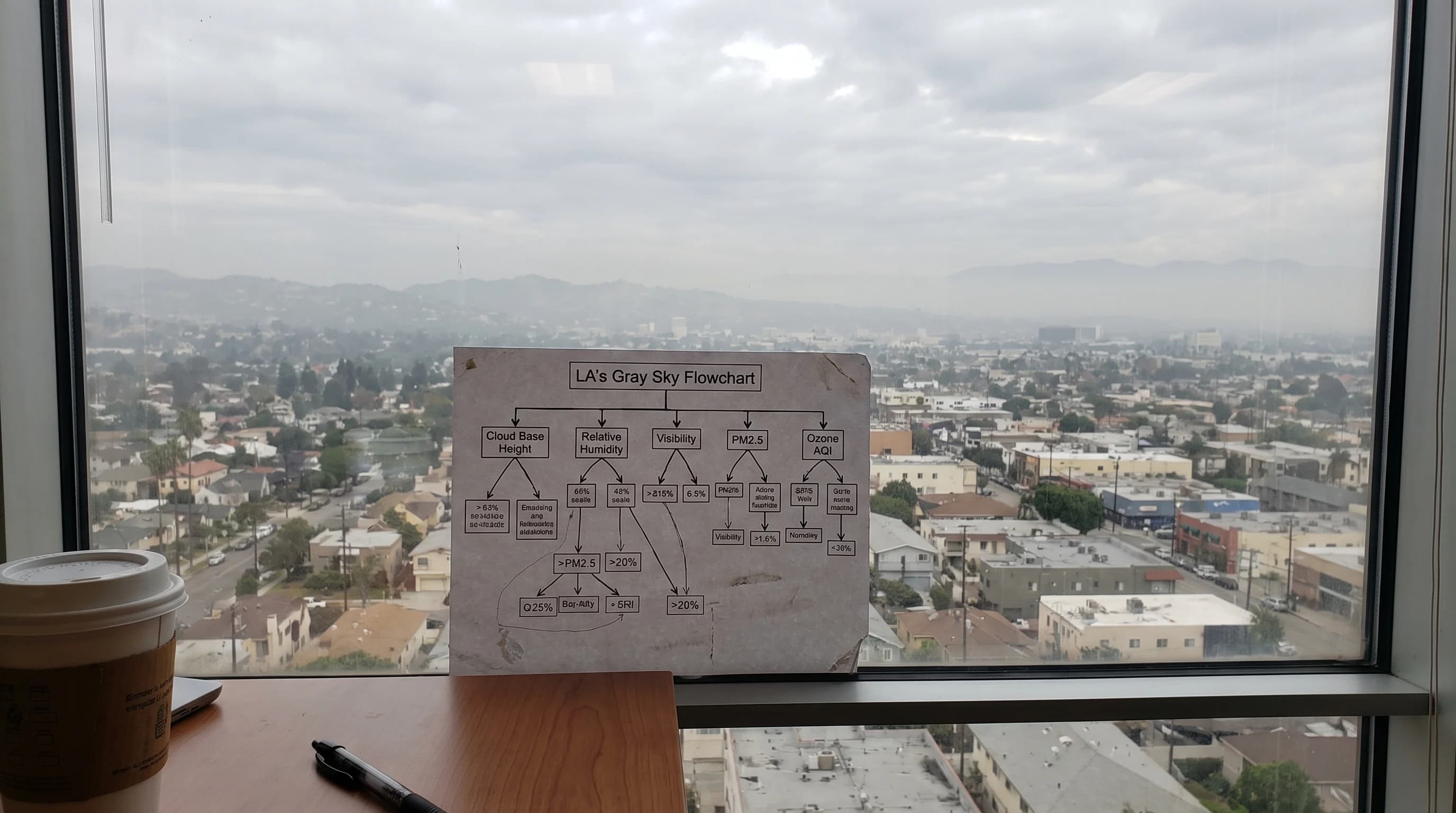
A diagnostic flowchart that walks through cloud base height, relative humidity, horizontal visibility distance, PM2.5 level, ozone AQI reading, satellite smoke detection, and time of day to narrow down whether gray Los Angeles sky is fog, mist, haze, or smoke
No single glance settles it. Cross-checking dew point spread, visibility, cloud base, and the dominant AQI pollutant is what actually separates fog, mist, and haze.

For the current read on any of these, WeatherEscape's Los Angeles fog and smoke forecast tools combine visibility, dew point, and AQI pollutant data by destination so you are not left guessing from a photo or a hazy commute. Two other comparisons are worth bookmarking alongside this one: cumulus vs. cumulonimbus clouds for reading storm development over the basin, and sleet vs. hail vs. graupel for sorting out what is actually falling during a rare cold Southern California storm. Winter pattern questions, including how ocean temperature cycles shift the odds of a wetter or drier season, are covered in El Niño vs. La Niña for a SoCal winter.

The short version holds up across every Los Angeles microclimate: fog and mist are water, sorted only by how far you can see through them, and haze is dry particulate, sorted by what is suspended in the air rather than how humid it is. Before deciding whether a gray morning over your destination is marine fog burning off or ozone haze building in, check WeatherEscape's live visibility, dew point, cloud base, and dominant AQI pollutant readings for that specific location rather than trusting the color of the sky alone.

Frequently Asked Questions

What is the difference between fog, mist, and haze?

Fog and mist are both suspended water droplets; the only difference is concentration, measured by horizontal visibility. Fog reduces visibility below 1 kilometer, while mist is the same process at a lighter concentration that leaves visibility at or above that threshold. Haze is different in kind, not just degree: it is reduced visibility from dry particles, such as dust, smoke, or the pollutants behind photochemical smog, and it does not require saturated air to form.

How do humidity and visibility help distinguish them?

A dew point spread near zero (air temperature close to the dew point) points to fog or mist, since water droplets only persist when air is close to saturation. A wide dew point spread combined with reduced visibility points toward haze, smoke, or dust instead. Reported visibility distance separates fog from mist directly: under 1 kilometer is fog, at or beyond 1 kilometer with visible graying is typically called mist, though observers do not always apply the term with perfect consistency.

Why does marine fog form along the Southern California coast?

Cold, upwelled Pacific water chills the moist marine air sitting above it until that air reaches saturation and condenses into fog droplets. A temperature inversion traps this cool, moist layer near the surface instead of letting it mix upward, and nighttime radiational cooling intensifies the effect, which is why marine fog is most common in the hours before and around dawn along the LA coast.

When is gray air more likely to be smog or smoke?

Smog is more likely when gray or brownish air builds through a warm, sunny afternoon in an inland basin, since photochemical ozone formation needs hours of sunlight to convert vehicle and industrial emissions into haze. Wildfire smoke can arrive at any hour with a distinct tan, orange, or gray tint and is confirmed by satellite smoke-tracking products. Moist coastal fog and mist, by contrast, typically clear from the coast inward by late morning as the marine layer burns off.

Can fog, haze, and smoke occur together?

Yes. Wildfire smoke can sit in a layer well above the surface while a separate marine fog or low stratus deck occupies the lowest few hundred feet, so a dimmed, hazy sky and a foggy coastline can occur for two unrelated reasons at once. Photochemical haze can also build within the same inversion that traps lingering coastal moisture, particularly in the San Gabriel Valley and San Fernando Valley.

What looks like fog but isn't fog?

Low stratus cloud sitting a few hundred to a couple thousand feet above the ground looks identical to fog from below but is not technically fog, because fog is specifically defined as a surface-based phenomenon. A driver can pass beneath this cloud deck as apparent fog near the coast and emerge above it into clear sky within minutes while climbing to higher elevation. Haze and smoke can also visually mimic fog at a distance despite being dry particulate rather than water droplets.

What visibility distance officially separates fog from mist?

The National Weather Service defines fog as reducing horizontal visibility below 1 kilometer, about 0.62 miles. Mist describes the same water-droplet process at a lighter concentration that leaves visibility at or above that 1-kilometer threshold while the air still looks and feels damp and gray.

Related Destinations

Live Los Angeles Conditions

Compare temperature, wind, clouds, and comfort across the map.

See which microclimates are clear, cool, windy, smoky, or warming up right now.

Open the Weather Map
Destinations☀️Smog Forecast🌫️Smog Heat Map🔒Privacy Policy📄Terms of Service