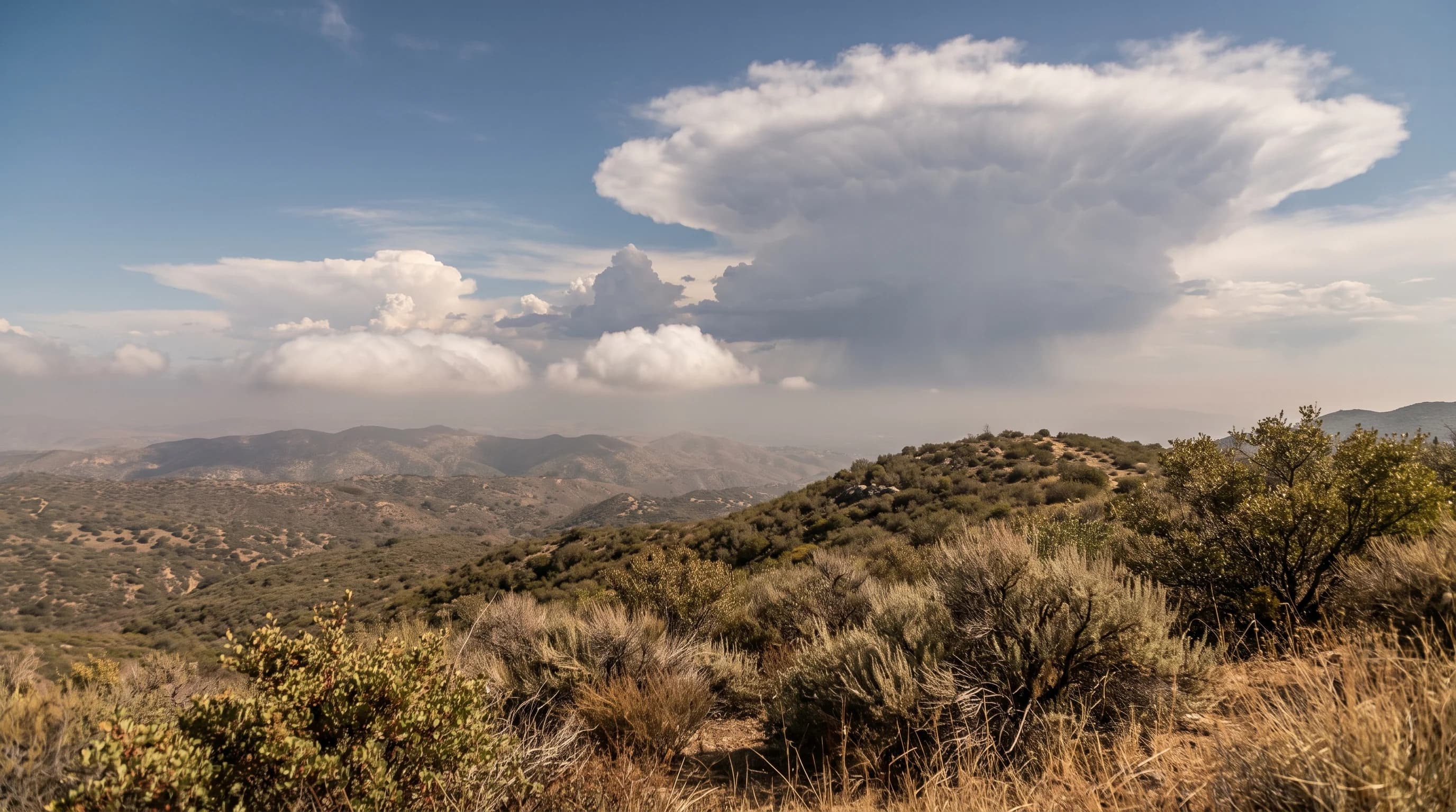
A cumulus cloud is a shallow, flat-bottomed puff that signals fair weather. A cumulonimbus cloud is a cumulus that has grown very tall into a thunderstorm, producing lightning, hail and heavy rain.
The key difference is height. A cumulus a few thousand feet tall stays harmless, while one that grows past the freezing level and develops a flat, icy top has become a cumulonimbus. Over Los Angeles, most puffy clouds on a summer afternoon are ordinary cumulus.
Telling cumulus from cumulonimbus by eye is a useful skill when hiking a ridge, driving a desert highway or standing on a beach as clouds build.
What Separates Cumulus From Cumulonimbus?
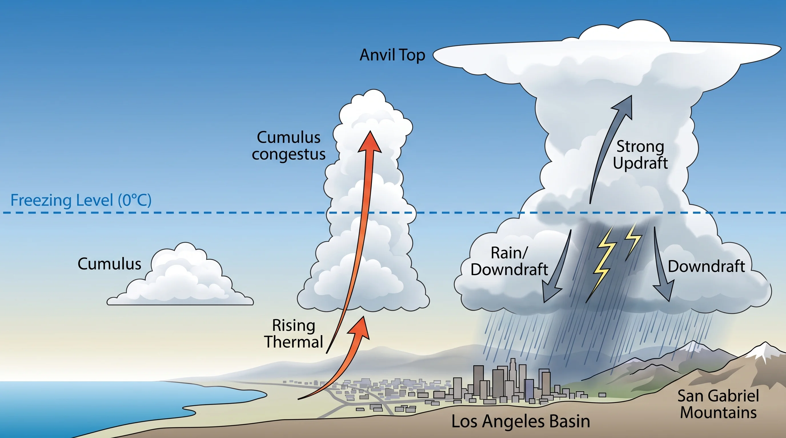
Cumulus and cumulonimbus are two stages of the same cloud life cycle, both driven by rising bubbles of warm air called thermals. The difference is how high the rising air goes and what happens to its moisture at the top. A basic fair-weather cumulus, called cumulus humilis, has a flat base and a slightly rounded top and is usually only a few thousand feet thick. It forms, drifts and often evaporates within 20 or 30 minutes.
A cumulonimbus is a cloud that has grown past the freezing level, often to 20,000 feet or higher, until its top froze into ice crystals and spread sideways into a flat anvil. The National Weather Service and NOAA's weather and atmosphere education resources define cumulonimbus by four features: great vertical depth, an ice-crystal top, an updraft strong enough to hold hail and heavy rain, and the electrical charge that produces lightning.
A tall cumulus whose top has not yet frozen is a towering cumulus, not a cumulonimbus. A towering cumulus can collapse or keep building into a full thunderstorm within the next 20 minutes. A cloud you see at the trailhead can look completely different by the end of your hike.
| Stage | What it looks like | Approximate depth | What it signals |
|---|---|---|---|
| Cumulus humilis | Small, flat-bottomed puffs, wider than tall | Roughly 1,000-3,000 feet | Fair weather; the classic "fair-weather cumulus" |
| Cumulus mediocris | Taller, more rounded lumps with modest vertical bumps | Roughly 3,000-6,000 feet | Growing instability; still no precipitation expected |
| Cumulus congestus (towering cumulus) | Sharp cauliflower-textured towers, noticeably taller than wide | Roughly 10,000-20,000+ feet | Transitional stage; can collapse or glaciate into a storm within 20-30 minutes |
| Cumulonimbus | Flattened, smeared, or anvil-shaped top; sharp towers give way to a fuzzy, icy crown | Often 30,000-45,000+ feet, sometimes higher in strong Southern California setups | Active or imminent thunderstorm: lightning, hail, heavy rain, gusty outflow |
How Does a Small Cumulus Grow Into a Thunderstorm?
A small cumulus grows into a thunderstorm when three ingredients last long enough for a thermal to keep rising: an unstable atmosphere, enough low-level moisture and a trigger such as afternoon heating over a mountain slope or desert. A rising thermal becomes the base of a cumulus cloud at the condensation level, where the air cools enough for water vapor to form droplets. If the thermal stays warmer than the surrounding air, it keeps rising. The cloud can grow from small cumulus to towering cumulus in about half an hour.
Most cumulus clouds over the Los Angeles Basin stop growing early. A subsidence inversion, a layer of sinking, warming air tied to the Pacific high, usually caps Southern California's air and stops rising thermals. A cumulus that reaches that cap flattens and spreads, or runs out of moisture and evaporates within 20 minutes.
The inversion cap is why a promising cloud tower over the San Gabriel Mountains on a July afternoon usually fades before 4 p.m. When the cap is weak or absent, usually because monsoon moisture or an unusually unstable air mass has arrived, the same tower keeps climbing past 20,000 feet.
What Visual Clues Show a Cloud Is Becoming Dangerous?
Fast vertical growth is the most reliable sign that a cloud is becoming dangerous. If a cloud tower grows visibly taller over five or ten minutes instead of drifting sideways, its updraft is strengthening.
A darkening, flattening base is a second sign that the cloud is thick enough to block sunlight and is forming rain or hail. A crisp, cauliflower-shaped top with hard edges is still growing. When the top turns soft, fibrous or smeared, it has frozen into ice crystals and the cloud has become a cumulonimbus.
An anvil, a flat shelf of cloud spreading from the top of the tower, confirms that a thunderstorm has matured. Below the cloud, watch for virga, rain streaks that evaporate before reaching the ground, and rain shafts, darker curtains that reach the surface. Both mean a downdraft has formed. At that stage, gusty, dust-raising outflow winds often reach the ground well before the rain.
Lightning can strike ten miles or more from the nearest visible rain, under clear sky at the storm's edge. A cumulonimbus does not need to be overhead or raining on you to be a lightning hazard.
Where Does Southern California See Each Cloud Type?
Fair-weather cumulus appears almost daily in Southern California's warm season, especially over the mountains and deserts. Towering cumulus and cumulonimbus are much less common and form mainly in two situations. The first is the North American monsoon, roughly July through September, when moisture from Mexico and the Gulf of California fuels afternoon thunderstorms over the San Gabriel and San Bernardino Mountains and the deserts beyond them.
The second is a cold winter storm, when a very cold upper-level low passes over moist air and triggers scattered thunderstorms. These winter storms sometimes reach the coast and the LA Basin, occasionally with small hail or waterspouts offshore.
The Los Angeles Basin and coast, including Downtown Los Angeles, rarely see cumulonimbus overhead, because the marine layer and cool coastal air suppress the instability storms need. Pasadena, at the base of the San Gabriels, and Woodland Hills in the western San Fernando Valley see more towering cumulus and occasional thunderstorms during monsoon season. Those areas sit closer to the terrain that lifts the air.
The NWS Los Angeles/Oxnard office and the NWS San Diego office issue separate forecasts for coastal, valley and mountain zones, because clouds behave differently in each on the same day.
Is That Pyrocumulus, a Lenticular Cloud, or a Storm Cloud?
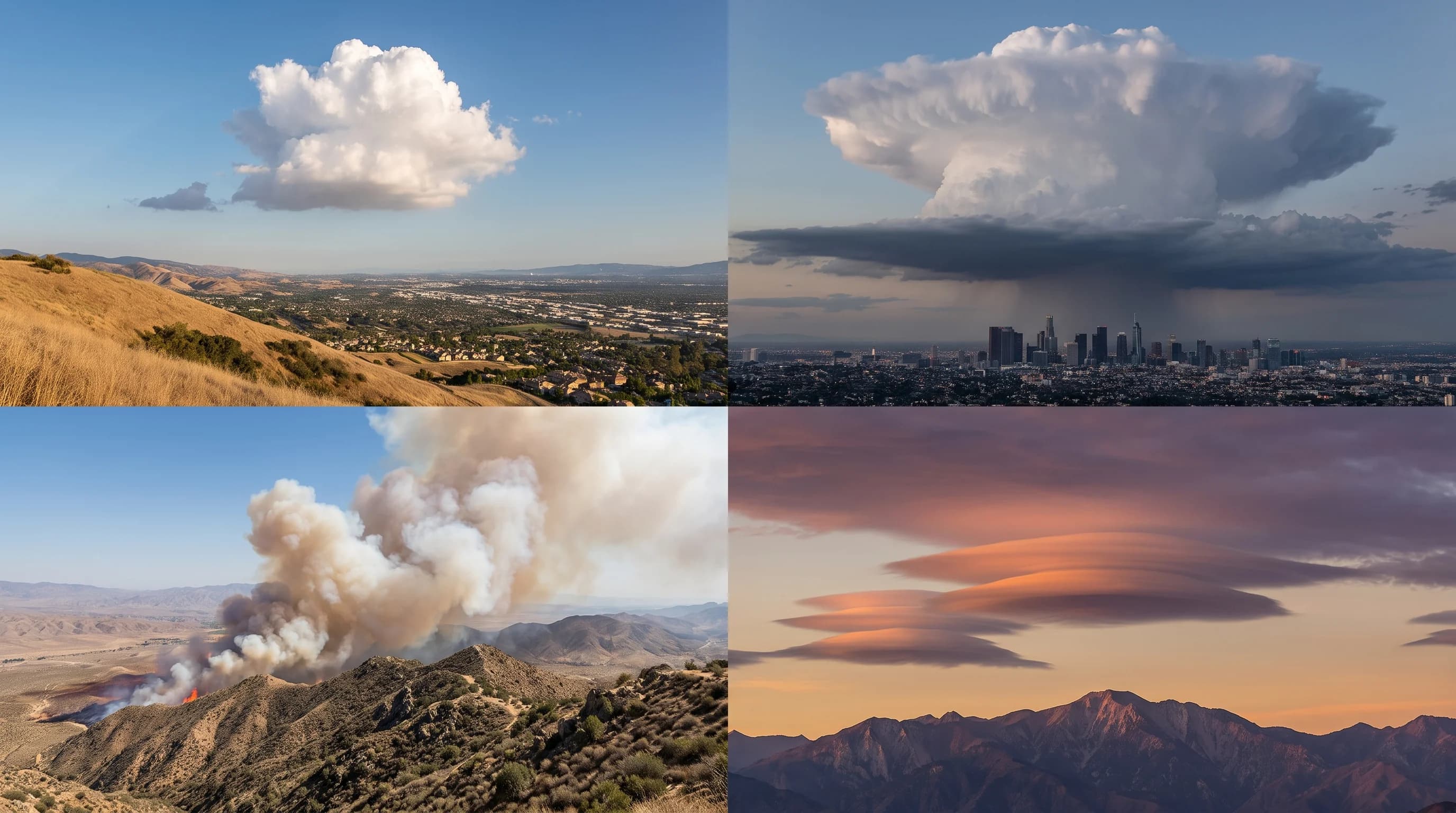
Pyrocumulus and lenticular clouds are the two most common look-alikes for a growing cumulonimbus over Southern California. A pyrocumulus forms directly above a burning wildfire, built by heat and smoke rather than sun-warmed ground. A pyrocumulus has a brownish-gray, smoke-tinted base connected to a smoke column below it. A cumulonimbus has a clean white-to-gray base over open terrain.
A lenticular cloud is a smooth, stationary, lens-shaped cloud that forms downwind of a mountain range, often near the San Gabriels and San Bernardinos. A lenticular cloud holds its shape and position for hours, even in strong wind, instead of billowing upward. A cumulonimbus has a cauliflower or fibrous texture, never smooth, and grows upward fast enough to watch. Neither a pyrocumulus nor a lenticular cloud shows that growth.
Pyrocumulus clouds over wildfires and the mountain waves behind lenticular clouds each have their own causes and hazards, separate from thunderstorms.
What Should You Do When Cloud Towers Build?
When cloud towers build, check official data right away. On an exposed ridge in the San Gabriels or San Bernardinos, a cumulus tower climbing over 10 or 15 minutes is the signal to check radar and any NWS thunderstorm outlook for your zone. A towering cumulus can become a lightning-producing cumulonimbus faster than you can hike down from an exposed summit.
On a desert highway or open beach, a distant anvil cloud can bring lightning long before its rain arrives. Blue sky overhead does not mean safety when a mature storm tower is nearby. The National Weather Service rule, "when thunder roars, go indoors," exists because thunder is a faster, more reliable danger signal than judging a cloud's distance.
Anywhere in Southern California, the next step is the same: check current radar, lightning data and any NWS warning for your zone, then compare it with the cloud overhead. Cloud shape gives early warning, but instruments and observers confirm a storm's location and strength.
Reading clouds buys time, not certainty. An aggressive-looking tower over a mountain trail or desert overlook can fade within the hour or become a full cumulonimbus while you decide what to do. When a tower builds fast over a ridge, desert basin or the coast, check radar, lightning and the NWS forecast for that destination before committing to the next hour outdoors.
For other sky-reading questions, see fog vs. mist vs. haze. For what falls from a Southern California storm cloud, see sleet vs. hail vs. graupel. The monsoon and cold winter storm patterns behind many local thunderstorms connect to the seasonal setup in El Niño vs. La Niña.