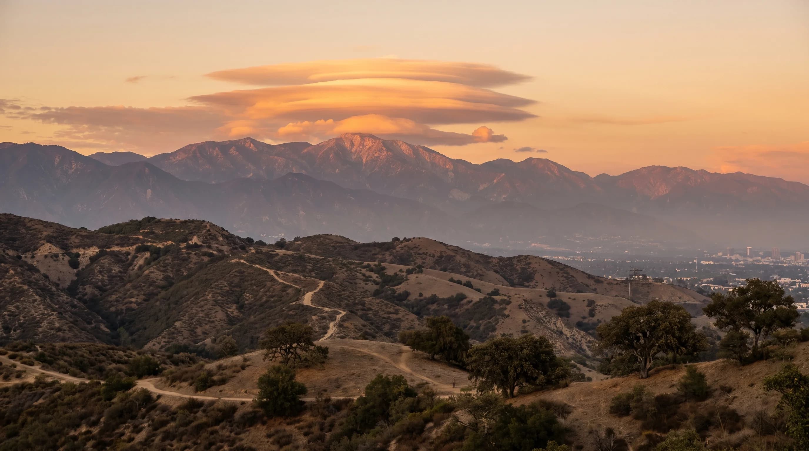
A lenticular cloud is a smooth, lens-shaped cloud that stays in one spot over a mountain range instead of drifting with the wind. Over the San Gabriel Mountains above Pasadena, lenticular clouds form when stable, moist air flows up and over the ridge and settles into a standing wave on the downwind side. The cloud forms at the top of that wave and holds its position as long as the wave lasts, sometimes for hours. That stillness makes it look unlike any other cloud in the sky.
What Is a Lenticular Cloud?
A lenticular cloud, formally a standing lenticular altocumulus, is a stationary, disc- or lens-shaped cloud that forms at the crest of a mountain wave instead of moving downwind like ordinary clouds. The name comes from the Latin word for lentil, for its smooth, rounded shape, which has prompted UFO reports since at least the mid-20th century. Its behavior sets it apart more than its shape: a lenticular cloud can stay fixed for an hour or more while strong wind blows through it.
A lenticular cloud stays still even though the air inside it is moving fast. The cloud marks a fixed spot, the crest of a standing wave, where rising air is cool and moist enough to condense.
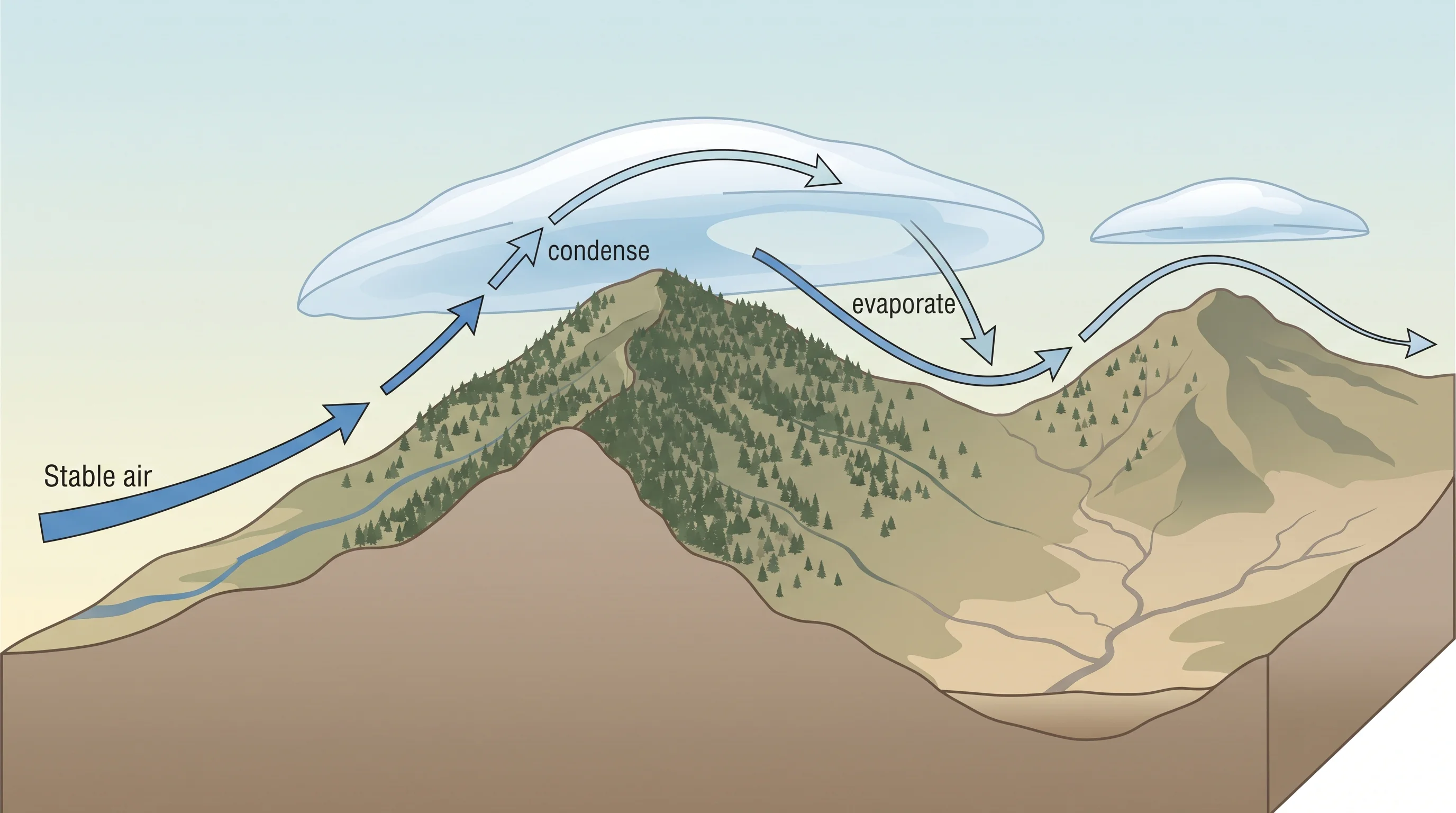
As air flows through that crest, new droplets form on the upwind edge and old ones evaporate on the downwind edge. The cloud looks motionless while its water is constantly replaced. The NOAA Weather and Atmosphere Education program classifies lenticular clouds as orographic clouds, formed by terrain rather than passing storms.
| Cloud type | Shape and motion | What actually causes it |
|---|---|---|
| Lenticular (standing wave) | Smooth lens or disc, fixed in place over terrain | Stable air rising and falling in a mountain wave downwind of a ridge |
| Cap cloud | Smooth cloud sitting directly over or on a single peak | Air forced up and over one summit, condensing right at the peak rather than downwind of it |
| Rotor cloud | Ragged, turbulent, roll-shaped cloud below the wave | Violent, tumbling circulation under the smooth wave crest, not the wave itself |
| Cumulus | Puffy, cauliflower-like, drifts with the wind | Localized daytime heating and rising, unstable air |
| Fog bank or marine layer | Flat, low, spreads horizontally near the surface | Cool, moist marine air pooling at low elevation, unrelated to mountain waves |
How Does Air Flowing Over a Mountain Create a Lenticular Cloud?
Air flowing over a mountain creates a lenticular cloud by rising and cooling into cloud at the crest of a standing wave, then sinking and warming back into clear air downwind. The wave pattern itself stays in place. When stable air hits a ridge like the San Gabriels, it must rise over it. In stable air, displaced air tends to return to its original level instead of rising freely as in a thunderstorm, so the up-and-down motion continues past the summit.
The motion continues downwind as a series of waves, like ripples behind a rock in a fast stream.
At the top of each wave, called the crest, rising air cools as it expands until it reaches its dew point and condenses into cloud. As the air passes the crest and sinks into the trough, it warms by compression and the droplets evaporate. The cloud keeps forming on its upwind edge and disappearing on its downwind edge. It appears to hang at a fixed height and position, sometimes as a stack of two or three lens shapes marking successive wave crests.
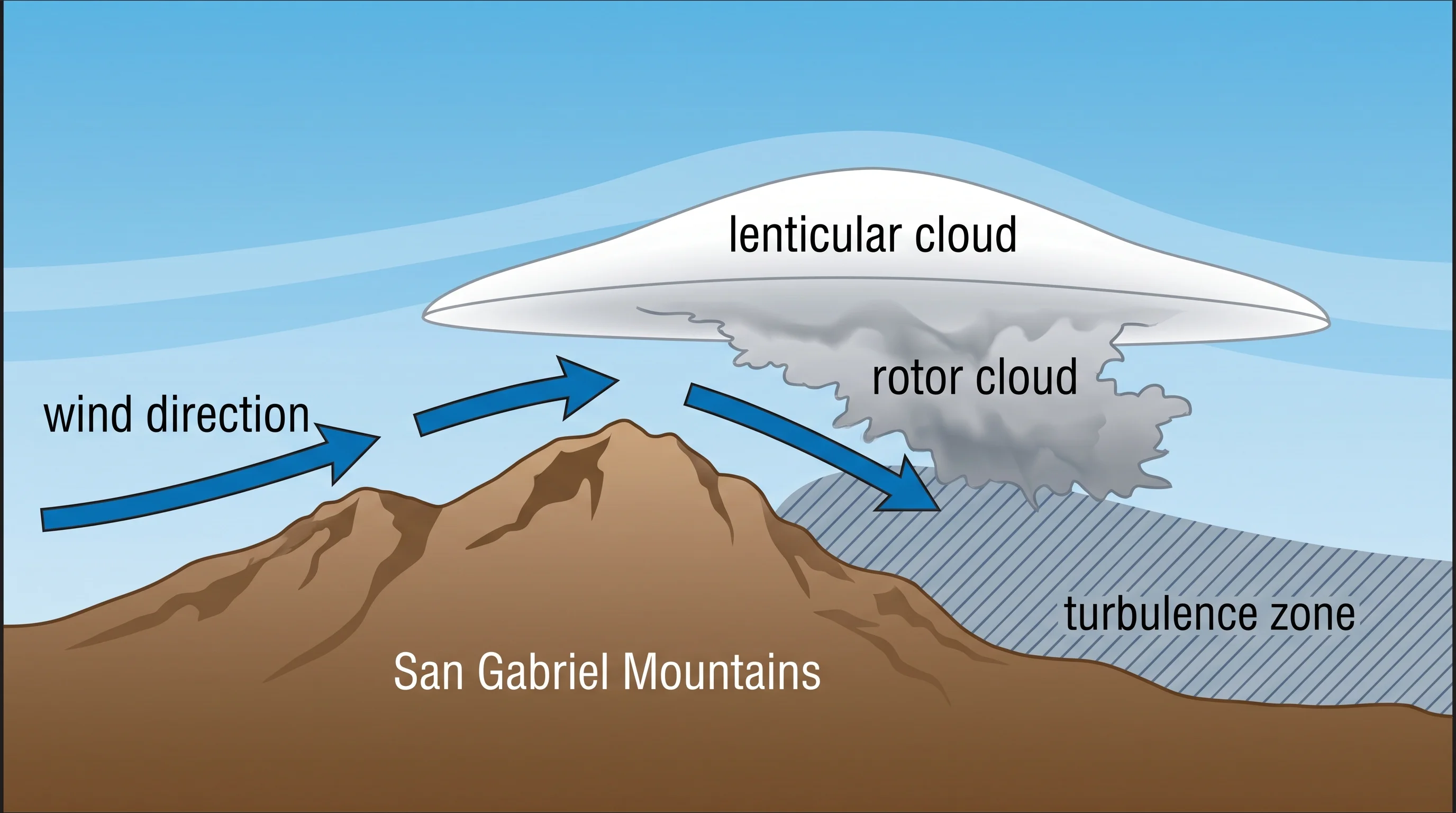
The air below a smooth lenticular cloud is often rough. A separate, ragged rotor cloud can form in the turbulent, tumbling air under the wave, and the rotor holds the worst turbulence.
Why Do Lenticular Clouds Form Over the San Gabriels?
Lenticular clouds form over the San Gabriel Mountains because the range rises sharply from the Los Angeles Basin, giving moist Pacific air a steep barrier to cross. A gentle slope would spread out the disturbance and weaken it. The San Gabriels climb from about 1,000 feet at Pasadena to more than 10,000 feet at Mount San Antonio within a short distance. That steep rise forces air upward fast enough to create a strong wave on the downwind, or lee, side.
Wind direction matters too. When wind blows roughly perpendicular to a ridge, the mountain blocks it like a dam and the wave is strongest. Wind running parallel to a ridge slides along it instead of climbing over, and the wave is much weaker.
Lenticular clouds also need moisture and stability. The air must hold enough water vapor to condense at the wave crest, and the air above the ridge must be stable enough that rising air sinks back instead of building into a thunderstorm. When cross-mountain wind, moisture and a stable layer aloft line up over the San Gabriels, forecasters at the National Weather Service Los Angeles/Oxnard office recognize the same setup that brings mountain-wave turbulence advisories for aircraft. That can happen even when the basin's weather looks ordinary.
For how the San Gabriels shape heat, fog and rain across the basin, see how LA's mountains shape its weather.
When Are Southern California Lenticular Clouds Most Likely?
Southern California lenticular clouds are most likely when strong, stable wind crosses the mountains with enough moisture at mid-levels, in any season. Santa Ana wind events are a classic trigger, pushing stable offshore air over the mountains. The weather pattern behind strong Santa Anas can produce dramatic lenticular clouds over the San Gabriel and San Bernardino Mountains before or after the driest, gustiest period. Pacific storms can also produce lenticular clouds in the stable air ahead of or behind a front, before showers develop.
Lenticular clouds depend on wind direction, stability and moisture, not the calendar. They can appear in a clear winter high-pressure pattern or during a spring transition. Heat or humidity in the basin says nothing about whether conditions aloft favor a mountain wave. Wind speed and direction at ridge level are the best predictor of a lenticular cloud over the San Gabriels, so check a current forecast.
Do Lenticular Clouds Predict Rain or Severe Weather?
Lenticular clouds do not predict rain or severe weather. They form in stable air, the opposite of the setup that produces thunderstorms and heavy rain, so lens-shaped clouds over the San Gabriels usually signal strong wind aloft, not an approaching storm. They do show that cross-mountain wind is present at the cloud's altitude, and roughly how strong it is. Pilots and forecasters read them as a sign of wind and stability, not precipitation.
Lenticular clouds can still appear in the stable air well ahead of an approaching Pacific front, so they do not promise continued dry weather either. They show current wind and moisture at ridge level, not a 24-hour forecast. For a rain forecast, check the point forecast from NWS Los Angeles/Oxnard or NWS San Diego. For the clouds that do signal rain, see cumulus vs. cumulonimbus: reading storm clouds over LA.
Where Are Lenticular Clouds Most Commonly Found in Southern California?
In Southern California, lenticular clouds appear most often over and downwind of the San Gabriel and San Bernardino Mountains and other ridges that rise sharply above lower ground, because a steep mountain barrier is needed for the standing wave. Mountain towns on the lee side of a range, including Wrightwood and Big Bear Lake, get some of the best views, with wave clouds stacked directly overhead.
From the basin floor, including around Downtown Los Angeles, lenticular clouds appear as distant, disc-shaped caps above the mountains to the north, clearest on windy days with clean air.
Lenticular clouds are not unique to Southern California. Any tall, steep mountain range with the right wind and moisture can produce them, including the Sierra Nevada, the Cascades and ranges worldwide. The San Gabriels are a reliable local example because the range rises steeply above a large city and Southern California often has stable, dry offshore wind. Millions of residents can see them regularly.
Why Do Pilots Avoid Mountain-Wave Clouds?
Pilots avoid mountain-wave clouds because the standing wave that forms a smooth lenticular cap can also produce severe turbulence, strong updrafts and downdrafts and a violently rotating rotor below the wave crest. These can exceed an aircraft's structural or control limits with little warning. The lenticular cloud often marks smooth air at the wave crest. The rotor cloud beneath it marks chaotic, tumbling wind shear that has contributed to serious small-plane accidents in mountains.
Strong mountain waves can also push an aircraft up or down thousands of feet per minute with no pilot input.
Lenticular clouds therefore serve as an informal aviation warning. The National Weather Service and Federal Aviation Administration issue mountain-wave and turbulence advisories, including AIRMETs for mountain obscuration and turbulence, when conditions favor wave activity. Pilots near the San Gabriels are trained to treat a lenticular sky as a cue to check those official products before flying near the ridge.
Pilots planning a flight near mountain-wave conditions should use NWS Los Angeles/Oxnard aviation weather products and a certified flight instructor's guidance, not a general explainer. For another invisible hazard near the region's airports, see what is wind shear.
Lenticular clouds are an easy piece of Southern California sky-watching: smooth, saucer-shaped markers of stable, fast-moving air crossing the San Gabriels, visible from Pasadena to the coast on clear, windy days. Enjoy them, and treat them as a signal to check conditions, not as a forecast. Before mountain travel, flying or hiking near the San Gabriels or San Bernardinos under a dramatic lenticular sky, check ridge-level wind and any NWS aviation advisory, and check current conditions for your mountain destination on WeatherLA.