windsafetysevere weatherphenomena

What Is Wind Shear? The Invisible Hazard Over LA's Airports

By WeatherLA|Published |Last updated |11 min read
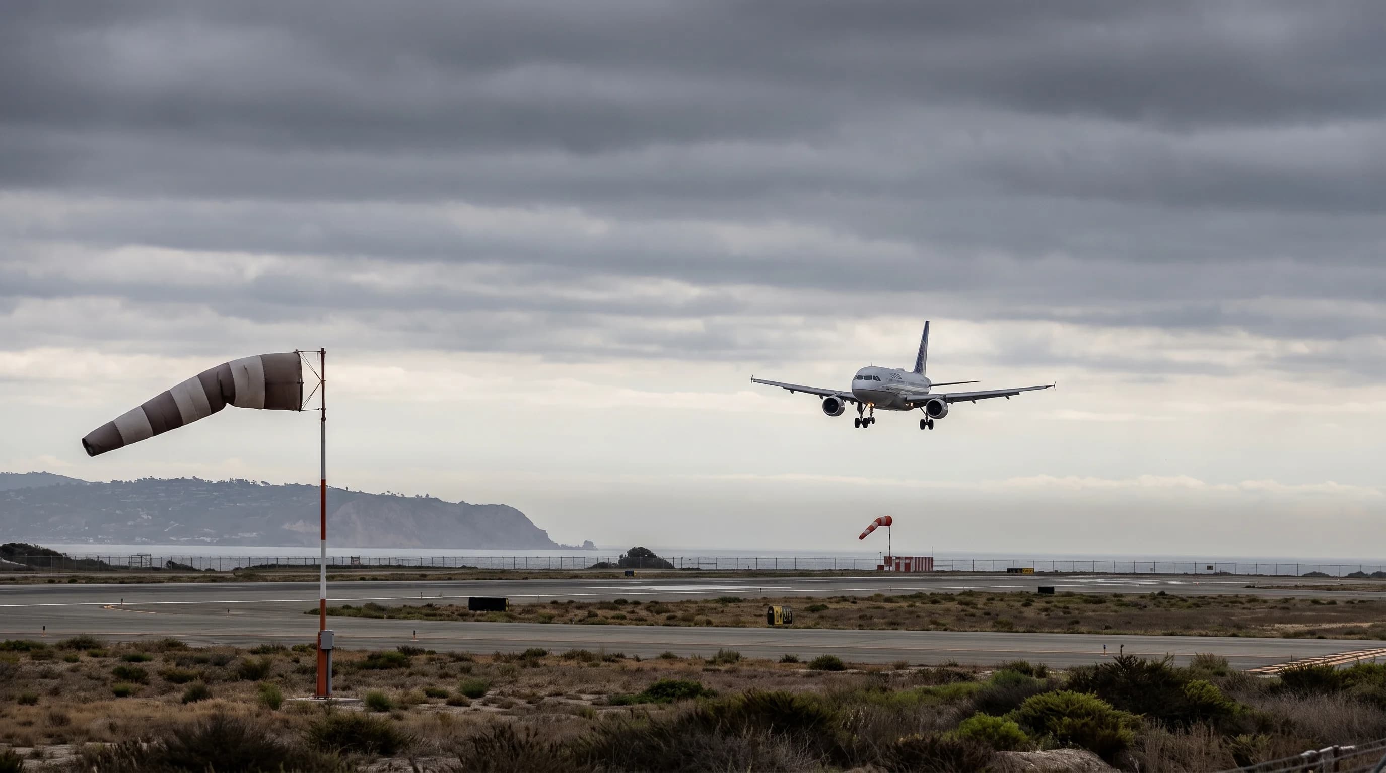
An arriving aircraft on final approach to a Los Angeles-area runway beneath layered clouds, with windsocks at different points along the field showing a realistic change in wind direction and speed

Key Takeaways

  • Wind shear is a rapid change in wind speed or direction across a short horizontal or vertical distance, not a single storm type or a synonym for gusty wind.
  • Around Los Angeles it forms from sea-breeze fronts, terrain funneling through mountain passes, Santa Ana downslope events, frontal passages, and thunderstorm outflow.
  • Low-level wind shear is most dangerous during takeoff and landing, when an aircraft has the least altitude and airspeed margin to recover from a sudden lift change.
  • A microburst always produces wind shear, but not every shear event is a microburst, and not every episode of turbulence involves shear at all.
  • Airports including LAX combine LLWAS ground sensors, Doppler radar, pilot reports, METAR observations, and NWS advisories to detect and warn of low-level shear in real time.
  • For a specific flight, check official airport observations, LLWS advisories, and FAA or airline status rather than relying on a general citywide wind forecast.

Wind shear is a rapid change in wind speed or direction over a short horizontal or vertical distance. Around Los Angeles it forms where sea-breeze fronts collide with inland heat, where terrain funnels and redirects airflow, where Santa Ana winds pour through mountain gaps, and where thunderstorm downdrafts spread out at the surface. Pilots care about it more than almost anyone else, because a jet on final approach into Burbank or Van Nuys can lose or gain airspeed in seconds if it flies through a sharp shear layer a few hundred feet above the runway.

What is wind shear?

Wind shear is any significant change in wind speed, wind direction, or both, measured across a short distance in the atmosphere. That distance can be horizontal, such as the boundary between a cool sea breeze and warm inland air, or vertical, such as the difference between the wind blowing at the surface and the wind blowing a few hundred feet above it. Meteorologists distinguish the two because they behave differently and threaten different things: horizontal shear concentrates rotation along a line, which matters for storm development, while vertical shear changes the wind an aircraft, balloon, or tall structure experiences as it moves up or down through the atmosphere in a short span of time.

The term covers a wide range of intensities. A gentle backing of the wind from onshore to offshore overnight is technically shear, and so is the violent, localized wind reversal beneath a collapsing thunderstorm cell. What makes shear a named hazard rather than just ordinary wind variability is the rate of change relative to the size of whatever is moving through it. An airliner covers a lot of vertical distance in a few seconds during takeoff or landing, which is exactly why aviation defines and monitors shear so precisely, using thresholds tied to airspeed loss rather than a single wind-speed number.

Wind Shear Sources Near Los Angeles Airports
Shear sourceTypical triggerWhere it shows up locallyTypical impact
Sea-breeze frontOnshore flow meeting warm inland airCoastal approach paths, LAX, Santa MonicaSudden shift in headwind to crosswind or tailwind
Terrain-channeled flowMountain gaps and canyon funnelingBurbank, Van Nuys, Santa Ana wind eventsGusty, direction-variable low-level wind on approach
Frontal passageCold or warm front crossing the basinBasin-wide, strongest near the surfaceRapid wind direction swing over minutes to an hour
Thunderstorm microburstCollapsing convective downdraftInland valleys and basin during summer convectionSevere, short-lived headwind-to-tailwind reversal near the ground
Nocturnal low-level jet / inversionStable layer decoupling surface and above-surface windBasin mornings and evenings, light-wind periodsVertical shear layer a pilot flies through on climb-out

What creates wind shear around Los Angeles?

Southern California generates wind shear through several distinct mechanisms that often overlap in the same afternoon. The most routine is the sea-breeze front, the boundary where cool, moist air pulled in from the Pacific meets warmer air that has been heating up over the basin and inland valleys all day. As that front pushes inland, typically in the afternoon, wind at the surface can swing direction by 90 degrees or more within a few miles, and the transition zone itself is a band of active shear rather than a clean line.

The strength of the push depends on how much the inland basin has heated relative to the ocean surface, so a hot inland day can pull the sea-breeze front through the coastal airports earlier and with a sharper wind change than a mild one.

Terrain adds a second layer. The San Gabriel and Santa Monica Mountains, along with passes like the Cajon and Newhall, channel and accelerate air moving through them, producing wind that can differ sharply in speed and direction from open, unobstructed stretches of the basin only a few miles away. This effect is strongest during Santa Ana wind events, when dry, downslope flow pours out of the mountains and interior deserts toward the coast, creating a sharp contrast between the gusty offshore air near the foothills and calmer conditions closer to the ocean. A ridge or canyon can also produce a localized rotor, a horizontal band of turbulent, reversing wind on the downwind side of terrain, which is a mechanical, terrain-forced cousin of the thermally driven shear a sea breeze produces.

Frontal passages associated with winter storms add a third source, since a passing cold front can swing the basin's prevailing wind direction within an hour, sometimes less, as the leading edge of colder air pushes through. Thunderstorm downdrafts, though less common in Southern California than in the Midwest, add a fourth and more violent one when convection does develop, typically during the warm season over the inland valleys and higher terrain. Low-level jets and nighttime temperature inversions round out the list, creating a stable layer near the surface that effectively decouples the wind above it from the wind at ground level.

On a calm, clear night the surface wind can drop to near nothing while a narrow ribbon of much faster air continues to flow a few hundred feet up, a vertical shear condition that is easy to miss from the ground but very real to an aircraft climbing or descending through it at dawn or dusk.

Why is low-level shear dangerous to aircraft?

Low-level wind shear is dangerous because an aircraft's lift depends on airspeed, and airspeed can change abruptly when the wind itself changes abruptly, especially close to the ground where there is little altitude left to recover. On approach, an aircraft flying from a headwind into a tailwind loses airspeed and lift at the same moment, which can cause it to sink below the intended glide path unless the crew responds quickly. The reverse situation, flying from a tailwind into a headwind, produces a sudden airspeed increase that can push the aircraft above the glide path. Both transitions demand a fast correction, and both are far more consequential a few hundred feet above a runway than they would be at cruising altitude with thousands of feet of room to spare.

Takeoff carries a related risk. An aircraft climbing out through a shear layer can encounter a sudden loss of headwind, or an outright tailwind, at exactly the point where it has the least excess airspeed and the engines are already working near their limits. This is why low-level wind shear, not wind shear generally, is the specific hazard aviation authorities monitor most closely near airports, and why the National Weather Service and the Federal Aviation Administration treat it as a distinct forecasting and alerting category rather than folding it into an ordinary wind advisory. The concern is airspeed and lift margin during the two phases of flight, takeoff and landing, when an aircraft is slowest, closest to the ground, and least able to absorb a sudden change.

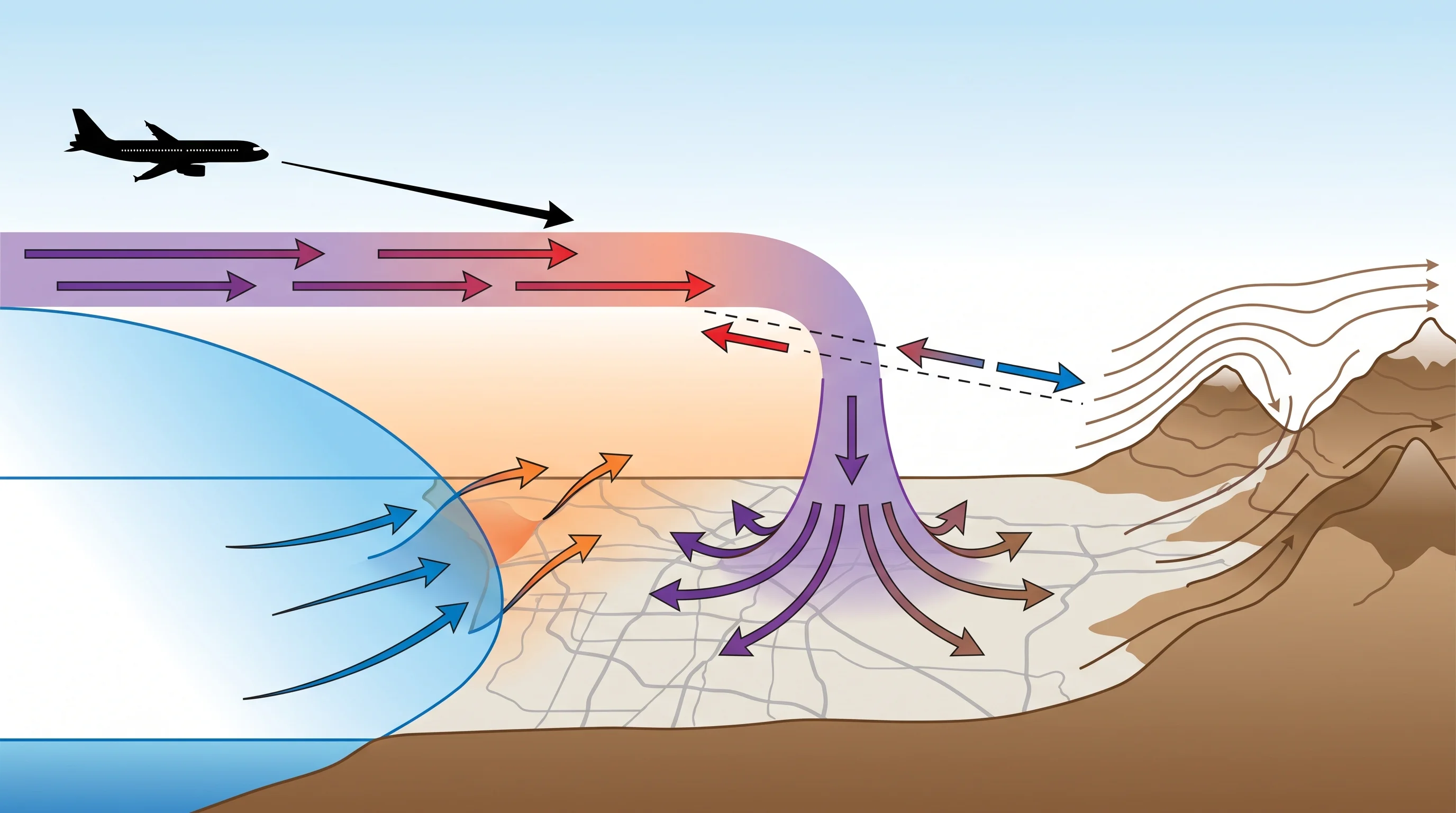
A final-approach cross-section diagram showing a sea-breeze boundary, a vertical wind shear layer, a microburst outflow spreading at the surface, a headwind-to-tailwind transition, and terrain influence from nearby mountains
Wind shear on final approach can come from a sea-breeze boundary, a vertical shear layer, a microburst outflow, or terrain funneling, sometimes more than one at once.

When are Southern California airports vulnerable?

Southern California airports face different shear risks depending on season, time of day, and each airport's specific geography relative to the coast and mountains. Coastal and near-coastal fields, including LAX and Santa Monica, are most exposed to sea-breeze-driven shear on warm afternoons, when the marine push inland can arrive as a fairly sharp boundary rather than a gradual wind increase. Airports set closer to the mountains and passes, including Burbank and Van Nuys, see more terrain-driven variability, particularly during Santa Ana wind events when downslope flow out of the San Gabriels can be gusty and direction-variable right over the runway environment while conditions a short distance away look calm.

San Fernando Valley communities such as Woodland Hills, which sit directly in the path of that downslope flow, often see the same gusty, direction-variable pattern at ground level that a nearby aircraft would encounter on approach.

Frontal passages during the cool season bring basin-wide shear risk as a storm's wind field rotates through, typically over an hour or two rather than the sharper sea-breeze transition. Santa Ana events themselves tend to cluster in the fall and winter months, when a strong surface high pressure system builds over the Great Basin and pushes dry air down through the mountain passes toward the coast, so the terrain-driven shear risk at Burbank and Van Nuys is not evenly spread across the year.

Summer and early-fall afternoons bring the least frequent but most intense risk, convective outflow from thunderstorms that do develop over the inland valleys and higher terrain, since a microburst's straight-line downdraft can produce a wind change far more abrupt than a sea breeze or a frontal passage. No single Southern California airport is immune, but the mix of risks, and the time of day and season each one peaks, differs enough by location that pilots and dispatchers treat the coast, the basin, and the mountain-adjacent fields as genuinely different operating environments, and a forecast that is calm for one is not automatically calm for another only a few miles away.

How is shear different from turbulence or a microburst?

Wind shear, turbulence, and a microburst are related but distinct terms, and mixing them up obscures what is actually happening in the atmosphere. Wind shear describes the wind gradient itself, the measurable change in speed or direction across a distance. Turbulence describes the bumpy, often chaotic response an aircraft experiences when it flies through disrupted air, which can be caused by shear but can equally be caused by convective currents, mountain waves, or wake from another aircraft with no shear involved at all. A microburst is narrower still: a concentrated, short-lived column of sinking air from a thunderstorm that spreads out in a straight-line pattern once it hits the ground, producing an intense, localized shear event as the outflow moves outward from the point of impact.

Every microburst produces wind shear, but not every wind shear event is a microburst, and not every episode of turbulence involves shear at all. A sea-breeze front, for example, generates real horizontal wind shear without producing a microburst or necessarily much turbulence, while a mountain wave downstream of the San Gabriels can produce significant turbulence with a comparatively gradual change in average wind. The distinction matters for how each is detected and warned: microbursts get their own detection systems and warning products because of how sudden and severe they are, while general low-level wind shear advisories cover the broader category.

A closer look at how these concentrated thunderstorm downdrafts form and behave locally is available in microbursts in Southern California thunderstorms, and the tornado-specific role of wind shear as a rotation ingredient is covered separately in can tornadoes hit Southern California.

How is the hazard detected?

Low-level wind shear is detected through a layered system that combines ground sensors, radar, and human observation. Many larger airports, including LAX, operate a Low-Level Wind Shear Alert System (LLWAS), a network of anemometers positioned around the airfield that compares wind readings at different points to flag a developing shear or microburst signal in real time. Terminal Doppler Weather Radar, where installed, adds the ability to detect the wind field of an approaching storm before it reaches the airport, giving controllers and pilots additional lead time on convective threats.

Between these automated systems, pilot reports, known as PIREPs, remain one of the most valuable sources of shear information, since a flight crew that experiences a sudden airspeed change on approach can relay that directly to air traffic control for following aircraft.

Routine airport weather observations, reported as METARs, capture surface wind speed and direction at regular intervals and flag rapid changes, while the National Weather Service Los Angeles/Oxnard office and the National Weather Service San Diego office issue forecasts and advisories that flag conditions favorable for low-level shear, such as an approaching front, a Santa Ana setup, or a thunderstorm outlook. The Federal Aviation Administration and individual airlines layer their own operational thresholds and pilot training on top of this data, and during an active event it is the combination, automated sensors, radar, human reports, and official advisories together, that gives controllers and flight crews a real-time picture rather than any single source alone.

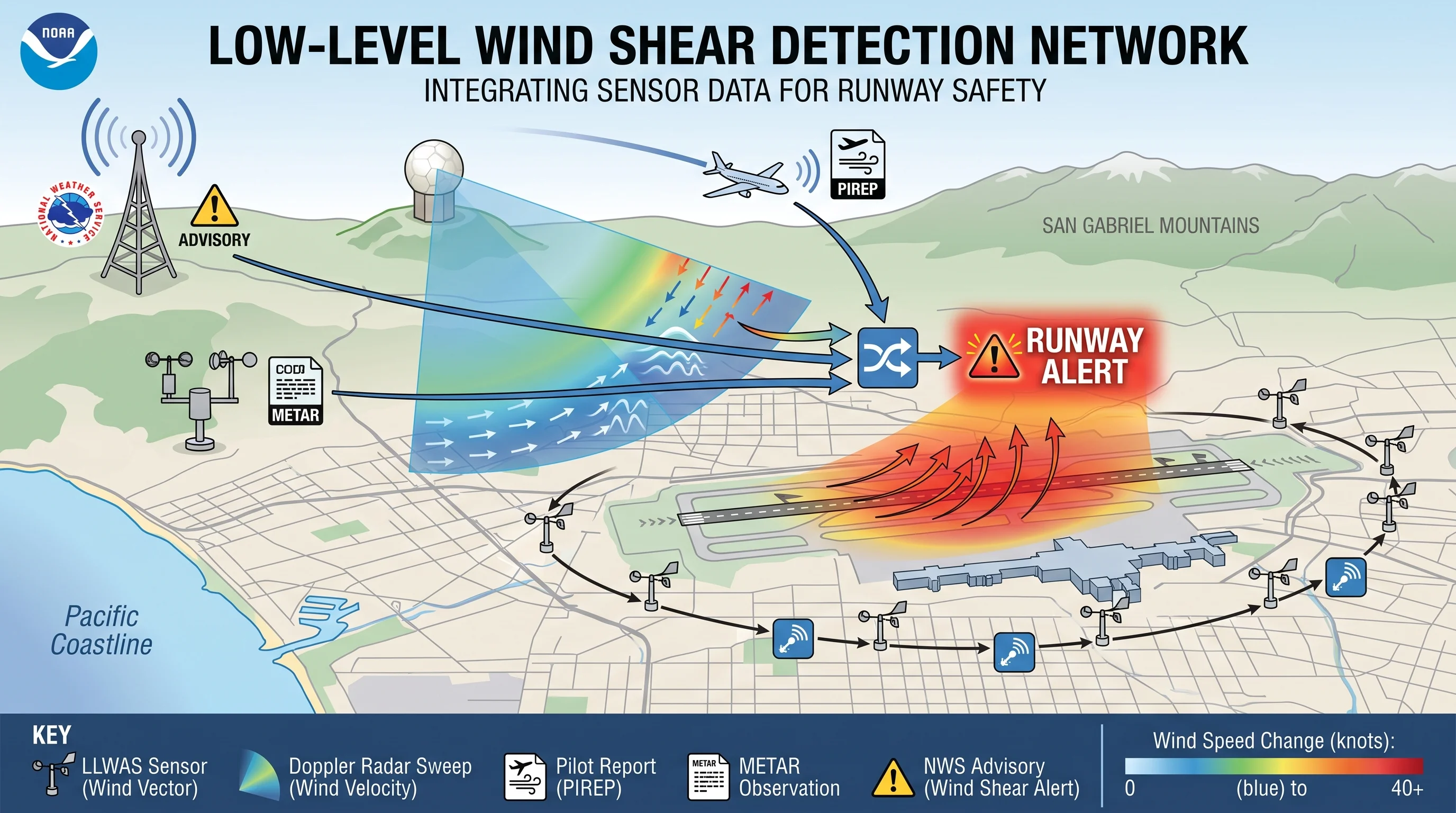
A detection graphic showing airport LLWAS sensors around a runway, a Doppler radar sweep, a pilot report icon, a METAR observation, and an NWS advisory feeding into a runway alert
Low-level wind shear detection near Los Angeles airports layers LLWAS sensors, Doppler radar, pilot reports, METAR observations, and NWS advisories into a single real-time picture.

Wind shear is not something a casual observer can see, which is exactly why it earns the label invisible hazard: the sky can look calm while the wind field a few hundred feet up, or a few miles inland, is changing fast enough to matter to an aircraft. If you are planning around a flight in or out of a Southern California airport during a Santa Ana event, an approaching front, or a summer thunderstorm outlook, check the official airport observations, LLWS advisories, and FAA or airline status pages rather than relying on a general citywide wind forecast, since shear is a highly local phenomenon that a basin-wide number cannot capture.

WeatherEscape's Los Angeles destination pages and forecasts for Pasadena, Burbank, and Van Nuys are a good starting point for general wind conditions across the region, but a specific flight always deserves the specific airport source.

Frequently Asked Questions

What is wind shear?

Wind shear is a rapid change in wind speed, wind direction, or both, measured across a short horizontal or vertical distance in the atmosphere. It can be as gentle as a sea breeze slowly backing the coastal wind through the afternoon or as violent as the outflow beneath a collapsing thunderstorm. What makes it a named hazard is the rate of change relative to the size of whatever is moving through it, which is why aviation defines and monitors it separately from ordinary wind variability.

What creates wind shear around Los Angeles?

Southern California wind shear comes from several overlapping sources: sea-breeze fronts where cool ocean air meets warm inland air, terrain funneling through mountain passes like the Cajon and Newhall, Santa Ana events pushing dry downslope wind toward the coast, frontal passages during winter storms, and thunderstorm downdrafts during warm-season convection. Nighttime temperature inversions add a vertical form, decoupling calm surface wind from faster air a few hundred feet above it.

Why is low-level shear dangerous to aircraft?

Low-level wind shear is dangerous because an aircraft's lift depends on airspeed, and airspeed can change abruptly when the wind changes abruptly. On approach, flying from a headwind into a tailwind causes a sudden airspeed and lift loss with little altitude left to recover, while the reverse transition can push an aircraft above its intended path. Both are far more consequential a few hundred feet above a runway during takeoff or landing than at cruising altitude.

When are Southern California airports vulnerable?

Coastal fields like LAX and Santa Monica face the most sea-breeze-driven shear on warm afternoons. Mountain-adjacent airports including Burbank and Van Nuys see more terrain-driven variability, especially during fall and winter Santa Ana events. Frontal passages bring basin-wide risk during winter storms, and summer and early-fall thunderstorm outflow, though less frequent, produces the most intense shear of any local source.

How is shear different from turbulence or a microburst?

Wind shear is the measurable change in wind speed or direction itself. Turbulence is the bumpy response an aircraft experiences flying through disrupted air, which shear can cause but so can convective currents or mountain waves with no shear involved. A microburst is a concentrated, short-lived thunderstorm downdraft that spreads out at the surface, producing an intense, localized shear event. Every microburst produces shear, but not every shear event is a microburst.

How do pilots and airports detect and respond to low-level wind shear at Los Angeles airports?

Detection layers several sources together: the Low-Level Wind Shear Alert System (LLWAS) at airports like LAX compares wind readings from sensors around the field, Terminal Doppler Weather Radar tracks approaching storm wind fields where installed, and pilot reports (PIREPs) relay real-time airspeed changes experienced in flight. METAR observations and National Weather Service advisories from the Los Angeles/Oxnard and San Diego offices round out the picture, and the FAA and individual airlines apply their own operational thresholds on top of that data.

How long does wind shear last?

Duration depends entirely on the source. A sea-breeze front produces shear along a moving boundary that can affect a given airport for an hour or more as the front passes through. A frontal passage during a winter storm can bring an hour or two of shifting wind. A thunderstorm microburst is far shorter and far more intense, typically lasting only a few minutes at a given location as the downdraft spreads out and dissipates, which is part of why it is treated as a distinct, higher-urgency hazard.

Has wind shear ever caused a plane crash?

Yes, low-level wind shear, particularly from microbursts, has been a documented factor in fatal accidents at U.S. airports in past decades, which is why the FAA and NWS built out dedicated detection systems like LLWAS and Terminal Doppler Weather Radar and why airline crews train specifically for shear encounters. Modern detection and mandatory crew training have substantially reduced this risk at equipped airports, but the hazard is the reason the alerting and monitoring systems described above exist in the first place.

Related Destinations

Live Los Angeles Conditions

Compare temperature, wind, clouds, and comfort across the map.

See which microclimates are clear, cool, windy, smoky, or warming up right now.

Open the Weather Map
Destinations☀️Smog Forecast🌫️Smog Heat Map🔒Privacy Policy📄Terms of Service