windphenomenaclimate sciencemicroclimates

Sea Breeze: Why LA's Wind Turns Onshore Daily

By WeatherLA|Published |Last updated |9 min read
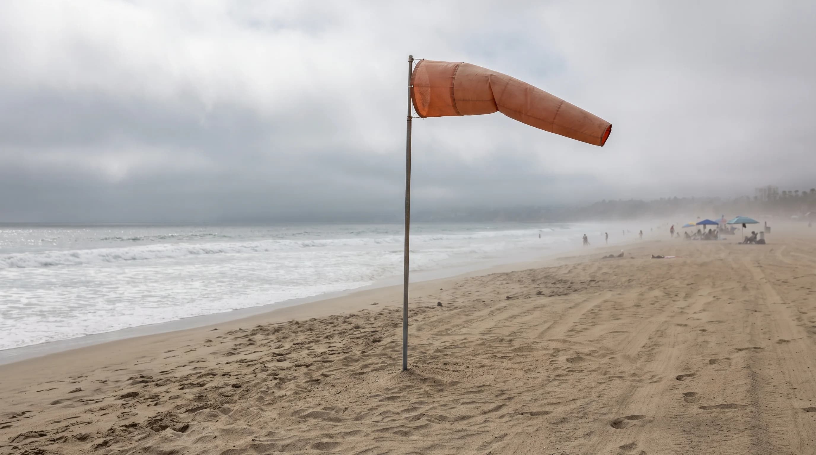
A summer afternoon panorama from Santa Monica inland, with beach flags snapping in a cool onshore wind at the coast and hotter, still air visible ahead of the sea-breeze front farther inland

Key Takeaways

  • A sea breeze is a daily, sun-driven wind, not a storm system; it forms because land heats much faster than the Pacific Ocean, creating a shallow pressure difference that pulls cooler marine air onshore.
  • The circulation is a shallow loop, typically only a few thousand feet deep, with onshore flow at the surface and a return flow moving back offshore aloft.
  • Onset and inland reach vary by season, cloud cover, and terrain; summer heating and a cleared-out marine layer let the breeze push farther and arrive earlier than it does in winter.
  • Coastal areas reached directly by the onshore flow cool the most; inland communities can heat up well before a weakened version of the breeze finally arrives.
  • The same afternoon wind shift that cools the coast also carries basin emissions and coastal smoke inland, which is a documented contributor to higher afternoon ozone readings away from the coast.
  • A shift from light or offshore morning wind to a steady onshore direction, visible in hourly NWS observations, is the clearest real-time sign the sea breeze has arrived at a given location.

A sea breeze is the onshore wind that develops most afternoons in Los Angeles because land heats up faster than the Pacific Ocean. As the ground warms, the air above it rises and pressure drops slightly inland, and cooler, denser air over the water flows in to replace it. That is why Downtown Los Angeles and Woodland Hills so often go from calm morning air to a steady onshore wind by mid-afternoon, and why that wind almost always comes from the direction of the ocean, not from inland.

What is a sea breeze?

A sea breeze is a local, daytime wind that blows from the ocean toward land, driven purely by the temperature difference between the two surfaces. It is a thermally direct circulation: no storm system, front, or large-scale pressure pattern is required to create it, only sunshine and the contrast between land and water. Water has a much higher heat capacity than land and mixes solar energy through a deeper layer, so the ocean surface barely changes temperature over the course of a day while asphalt, rooftops, and dry soil inland can climb 20 to 30 degrees Fahrenheit between sunrise and mid-afternoon. That mismatch in heating rate is the entire mechanism.

It is a different phenomenon from the Los Angeles marine layer, which is the shallow, moist air mass and stratus cloud deck that forms under a temperature inversion; a sea breeze is the wind itself, and it can blow under clear skies with no cloud involved at all, as explained in why LA mornings turn gray.

A Typical Los Angeles Sea Breeze Day, Stage by Stage
StageApproximate timeWhat is happening
Morning calmSunrise to mid-morningLand and ocean temperatures are close, so winds are light and variable near the coast before the day's heating gets underway
OnsetLate morningInland surfaces warm faster than the ocean, a pressure difference forms, and a light onshore breeze begins at the immediate coastline
Inland penetrationEarly to mid-afternoonThe breeze strengthens and pushes inland through the coastal basin, reaching communities like Pasadena as inland heating peaks
Peak strengthMid to late afternoonOnshore wind is typically strongest when the land-ocean temperature contrast is largest, often coinciding with the afternoon temperature maximum inland
Evening reversalAfter sunsetLand cools faster than the ocean once the sun sets, the pressure contrast weakens and can reverse, and winds ease or shift into a weaker offshore land breeze overnight

How does the circulation develop?

The circulation develops in a shallow layer near the surface, not through the whole atmosphere. As inland ground heats, the air directly above it warms, expands, and rises, which lowers surface air pressure slightly compared to the cooler air sitting over the ocean. Air always moves from higher pressure to lower pressure, so cooler marine air flows inland at the surface to fill that gap. That incoming marine air is what people feel and call the sea breeze. The circulation does not stop at the surface: the inland air that rose has to go somewhere, so it spreads out aloft and sinks back down over the ocean, completing a loop a few thousand feet deep.

This return flow aloft moves in the opposite direction, offshore, well above where anyone standing on a beach or in a parking lot in Pasadena would notice it. The whole circulation is a response to unequal heating, which is also the same basic physics behind why the interior deserts get so much hotter than the coast and why summer monsoon thunderstorms build over the deserts rather than at the beach, a related but separate pattern covered in what is the monsoon.
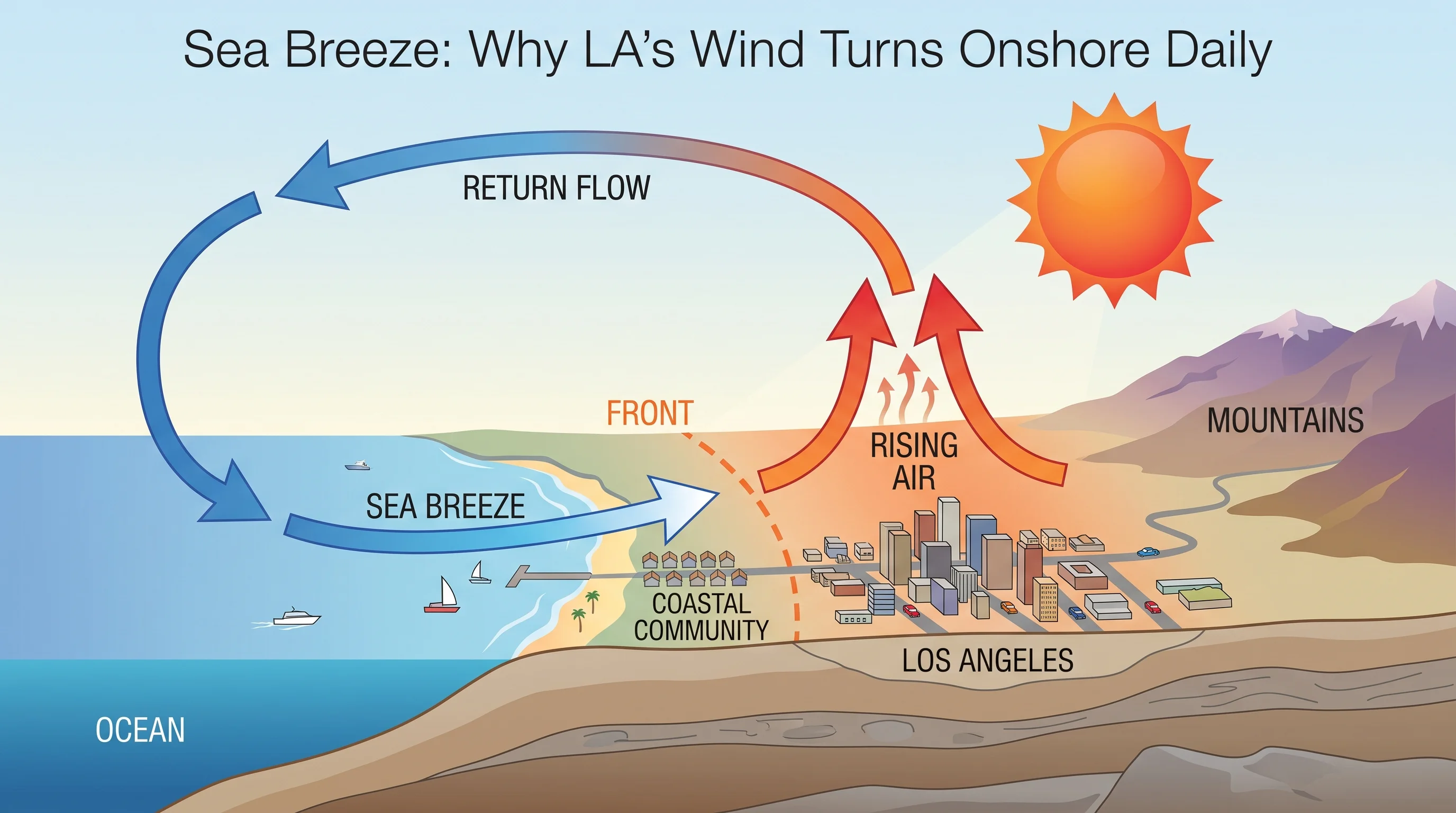
A daytime cross-section illustration showing the Pacific coast to inland Los Angeles, with warm rising air over heated land, a shallow onshore wind arrow at the surface labeled sea breeze, a return flow arrow aloft heading back toward the ocean, and a front position marker where the two air masses meet
A sea breeze is a shallow, thermally driven loop: cooler ocean air flows inland at the surface while the rising inland air it displaces sinks back over the water a few thousand feet up.

When does it reach different parts of Los Angeles?

Onset and inland penetration depend on how much heat inland surfaces build up relative to the ocean, which varies by season, cloud cover, terrain, and the larger-scale wind pattern already in place that day. In summer, when the sun angle is high and inland valleys heat aggressively, the sea breeze tends to start earlier and push farther inland than it does in winter, when weaker heating produces a smaller temperature contrast and a more modest circulation.

A persistent morning marine layer can also delay onset, since overcast skies at the coast slow inland heating and postpone the pressure difference that drives the breeze; once the marine layer burns off and sun reaches the ground, the sea breeze can develop quickly. Terrain matters just as much as season. Mountain ranges and hill ranges that ring the Los Angeles Basin can block, channel, or slow the inland push of marine air, so the same afternoon sea breeze can arrive at Downtown Los Angeles well before it reaches valley communities on the far side of intervening high ground.

A pre-existing offshore flow, such as a Santa Ana wind event, can also suppress or delay the sea breeze entirely for a day, since the sea breeze is a comparatively weak, local circulation that can be overwhelmed by a stronger regional wind pattern moving in the opposite direction.

How much cooling can it provide?

The sea breeze reliably cools the areas it reaches, but the size of that cooling varies by location and by how hot the day was before the breeze arrived, so there is no single fixed number that applies everywhere. Coastal communities that receive the onshore flow directly, and early in the day, tend to see afternoon temperatures level off or even fall slightly compared with the late-morning peak, since incoming marine air is cooler than the air it replaces.

Locations farther inland, including much of the San Fernando Valley and the eastern basin, can still get hot before the sea breeze arrives, or may only receive a weakened version of it after it has traveled miles over already-heated ground and lost some of its cooling punch. On a hot inland day, comparing observations at a coastal station against an inland station a few hours apart is the clearest way to see the sea breeze's effect directly, since the two locations can be tracking similar temperatures in the morning and then diverge sharply once the onshore flow reaches one but not the other.

The National Weather Service Los Angeles/Oxnard office publishes current observations from stations across the coast and basin that make this side-by-side comparison possible on any given afternoon.

How does the front move fog, smog, or smoke?

The sea breeze does not just move air; it moves whatever is in that air, which makes it directly relevant to fog, smog, and wildfire smoke even though each of those phenomena has its own separate cause. Onshore flow can carry marine stratus and fog inland along with the cooler air, which is one reason coastal fog can push into low-lying inland areas during the afternoon in a way it could not on a still day; the marine layer and fog mechanics themselves are covered in more depth in why LA mornings turn gray and May Gray and June Gloom.

On the pollution side, the sea breeze plays a well-documented role in the Los Angeles Basin's ozone and smog pattern: emissions from the coastal and central basin get carried inland during the afternoon onshore flow, and the surrounding mountains that ring the basin can trap that polluted air against rising terrain, which is a major reason inland valley communities often record higher afternoon ozone readings than the coastal areas where much of the pollution originated. The U.S. Environmental Protection Agency and the South Coast Air Quality Management District both track this basin-wide transport pattern as part of regional air quality monitoring.

Wildfire smoke can behave similarly: a sea breeze can push offshore or coastal smoke inland during the day, then weaken or reverse at night, contributing to the kind of morning-to-afternoon smoke swings that inland communities sometimes notice during fire season.

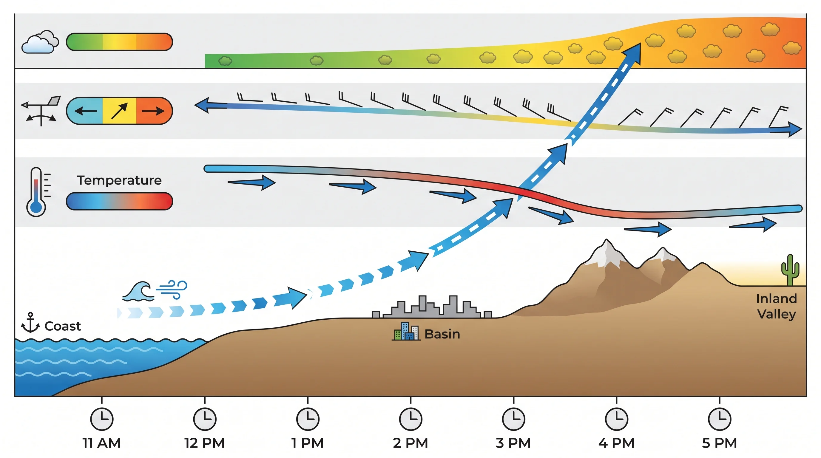
An hourly transect chart of Southern California tracking a sea-breeze front as it moves from the coast through the Los Angeles Basin toward inland valley stations, with tracks for wind direction shift, temperature change, and afternoon ozone levels
As the sea-breeze front advances through the day, coastal, basin, and valley stations each record the same wind shift and temperature change at different hours, and afternoon ozone often rises inland as the flow carries basin emissions with it.

How can readers see it in a forecast?

The clearest forecast signal is a wind direction shift: watch for hourly forecasts or current observations to shift from light, variable, or offshore morning winds to a steadier onshore direction, typically out of the west or southwest along most of the Los Angeles coastline, as the afternoon develops. Coastal observation stations, available through the National Weather Service Los Angeles/Oxnard office and the San Diego office for areas farther south, report live wind speed and direction that will show this shift in real time on a hot day.

A widening surface pressure gradient between the coast and the inland valleys and deserts, visible in NWS forecast discussions, is another sign that a stronger-than-usual sea breeze, or its stronger regional cousin sometimes discussed alongside offshore Santa Ana events, is likely. Because timing varies so much by location, the most useful approach for planning an afternoon outdoors is checking the specific hourly forecast, wind shift, and temperature trend for your destination rather than assuming a single citywide onset time. Readers should also not confuse a sea breeze wind shift with a tsunami warning wind change; the two share no mechanism, and anyone with questions about coastal hazards along the same shoreline should see can a tsunami hit Southern California rather than treating ordinary onshore wind as a warning sign.

The sea breeze is one of the most dependable patterns in Los Angeles weather, and also one of the easiest to check for yourself: a wind shift toward onshore, a leveling or drop in coastal temperature, and a lag before that same relief reaches inland communities. Before planning an afternoon at the beach, a hike inland, or an outdoor event anywhere between Downtown Los Angeles and Woodland Hills, check the current hourly wind direction, temperature, and forecast trend for that destination on WeatherEscape so you know whether the sea breeze has already arrived or is still working its way inland.

Frequently Asked Questions

What is a sea breeze?

It is a local, daytime wind that blows from the ocean toward land because the land surface heats up faster than the ocean. The temperature contrast lowers air pressure slightly inland, and cooler air over the water flows in at the surface to replace it, with no storm or front required.

How does the sea breeze circulation develop?

Warming inland air rises and creates slightly lower surface pressure than the air sitting over the cooler ocean, so marine air flows inland to fill the gap. The inland air that rose has to go somewhere, so it spreads out and sinks back over the ocean a few thousand feet up, completing a shallow, thermally driven loop.

When does the sea breeze reach different parts of Los Angeles?

Onset and inland penetration depend on season, cloud cover, and terrain. Strong summer heating typically brings an earlier, farther-reaching sea breeze than winter's weaker temperature contrast produces, a lingering morning marine layer can delay onset, and mountain and hill terrain around the Los Angeles Basin can slow or block how far inland the breeze pushes on a given day.

How much cooling can the sea breeze provide?

The cooling is real but varies by location and by how hot the day already was, so there is no fixed number that applies everywhere. Coastal areas reached directly by the onshore flow often see afternoon temperatures level off or fall, while inland communities can heat up substantially before a weaker version of the breeze finally arrives.

How does the sea-breeze front move fog, smog, or smoke?

The same onshore flow that cools the coast also transports whatever is in that air. It can push marine stratus and fog farther inland during the afternoon, and it carries coastal and basin emissions inland toward the surrounding mountains, a pattern the EPA and South Coast Air Quality Management District both track as a contributor to higher inland afternoon ozone readings.

How can readers spot the sea breeze in a forecast?

Watch hourly wind observations for a shift from light, variable, or offshore morning wind to a steadier onshore direction, typically out of the west or southwest along most of the LA coastline. The National Weather Service Los Angeles/Oxnard and San Diego offices publish live station observations that show this shift as it happens.

Is a sea breeze the same thing as the Los Angeles marine layer?

No. The marine layer is the moist air mass and low stratus cloud deck trapped beneath a temperature inversion, while the sea breeze is a wind driven by land and ocean heating differences. A sea breeze can blow under completely clear skies with no marine layer present at all.

Does the sea breeze reverse at night?

Yes. After sunset, land cools faster than the ocean, so the daytime pressure contrast weakens and can reverse. Onshore wind typically eases in the evening and can be replaced overnight by a weaker offshore land breeze, before the cycle restarts the next morning once the sun begins heating the land again.

Related Destinations

Live Los Angeles Conditions

Compare temperature, wind, clouds, and comfort across the map.

See which microclimates are clear, cool, windy, smoky, or warming up right now.

Open the Weather Map
Destinations☀️Smog Forecast🌫️Smog Heat Map🔒Privacy Policy📄Terms of Service