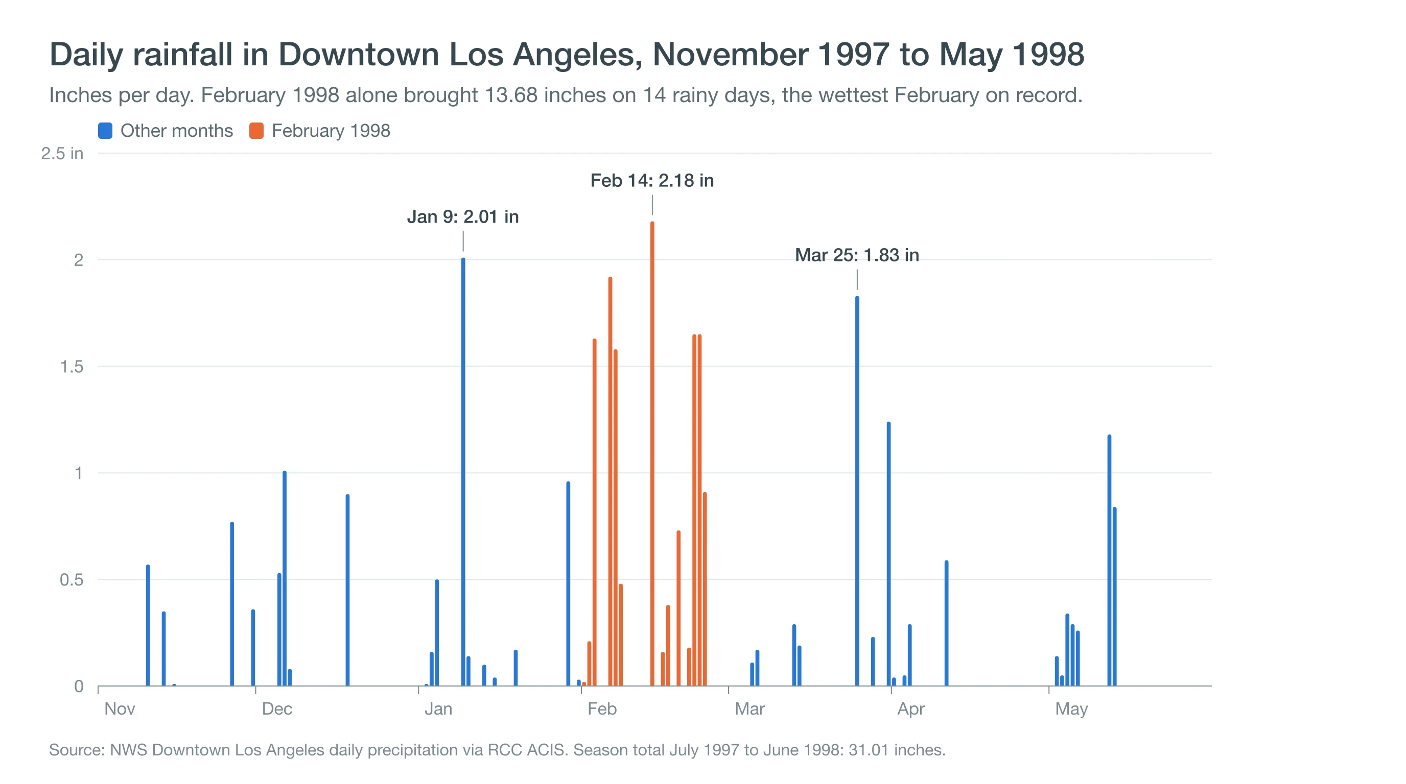
The 1997-98 El Niño gave Downtown Los Angeles 31.01 inches of rain from July 1997 to June 1998, more than double today's normal. February 1998 alone brought 13.68 inches, still the wettest February in records that go back to 1877. LAX had the wettest season in its history. By late February, Los Angeles County had been added to a federal disaster declaration.
The 1997-98 winter matters again because the Pacific is running even warmer now. NOAA's weekly Niño-3.4 reading hit 3.1°C above normal for the week of September 23, 2026, the highest in a series that starts in 1982, and forecasters give a very strong El Niño better than 90% odds this winter. This guide covers what the 1997-98 El Niño did to Los Angeles and what LA's rain record says about the next one.
How Much Rain Did Los Angeles Get During the 1997-98 El Niño?
Los Angeles got about twice its normal rainfall during the 1997-98 El Niño, at nearly every station. Downtown's 31.01 inches ranks as the seventh-wettest July-to-June season since 1877, and on the October-to-September water year the National Weather Service now uses, the total is 30.57 inches, 215% of normal. At LAX, 31.28 inches made 1997-98 the wettest season since the airport's records began in 1944. Foothill and Valley gauges recorded even more.
| Station | 1997-98 season | 1991-2020 normal |
|---|---|---|
| Downtown Los Angeles | 31.01 in | 14.25 in |
| LAX | 31.28 in (wettest on record) | 12.23 in |
| Long Beach | 29.68 in | 12.02 in |
| Pasadena | 39.17 in | 20.08 in |
| Woodland Hills | 40.19 in | 16.41 in |
February 1998 is the famous month, but the whole winter was wet. Downtown picked up 2.52 inches in December, 4.12 in January, 4.06 in March and then 3.10 inches in May, the second-wettest May on record. When comparing 1998 with today, note that the official Downtown gauge then sat at the Department of Water and Power building, before it moved to USC in 1999 and to Elysian Park, beside Dodger Stadium, in 2024. The Los Angeles rainfall totals page explains how those moves affect the record.
What Happened in LA During February 1998, Week by Week?
February 1998 brought rain to Los Angeles on 14 of its 28 days, in five distinct waves of storms. The first storm brought 1.84 inches on February 2 and 3. The second was bigger: 3.98 inches from February 6 through 8, and on the 8th, fans at the Los Angeles Memorial Coliseum were photographed taking cover during a CONCACAF Gold Cup match between Brazil and El Salvador.
The wettest single day of the winter was February 14, with 2.18 inches, when couples lined up in the rain outside the Hollywood Palladium for a Valentine's Day group wedding organized by a Spanish-language radio station. The day before, crews in Canoga Park were already shoring up homes that mudslides threatened to carry downhill. Lighter rain followed from February 16 to 19, and then the final wave dropped 4.39 inches from February 21 to 24, flooding streets in Santa Clarita as saturated hillsides gave way. On February 26, President Clinton added Los Angeles and Orange counties to California's federal disaster declaration.
Where Did Flooding, Mudslides and Coastal Damage Hit Southern California?
Flooding, mudslides and coastal damage hit Southern California from the beaches to the foothills, and the coast braced first. On December 5, 1997, bulldozers were piling 15-foot sand berms at Santa Monica and Venice to hold back storm surf on top of higher-than-normal sea levels. In January, surfers rode waves as high as 16 feet at Manhattan Beach.
Inland, the damage came from saturated ground. Hillsides slid in Canoga Park and Santa Clarita, the Pacific Coast Highway near Malibu was buried under about two feet of mud, and on March 19, 1998 a landslide in Laguna Niguel destroyed two homes and seven condominiums. How soaked hillsides fail is explained in why LA's hills give way after rain.
Statewide, contemporary reports counted 17 storm deaths and more than half a billion dollars in damage, with 35 counties declared disaster areas. The famous destruction of the Santa Monica Pier did not happen in 1998. It happened on January 27, 1983, during the 1982-83 El Niño, when storm surf tore away a 400-foot section, more than a third of the pier.
Why Was 1997-98 So Wet in Los Angeles?
The 1997-98 winter was so wet because a strong El Niño warmed the central and eastern tropical Pacific. The extra heat and thunderstorms there strengthened the subtropical jet stream and stretched it east toward California. That winter, the jet aimed storm after storm at Southern California rather than the Pacific Northwest, a pattern explained in how El Niño and La Niña shape a SoCal winter.
El Niño made storms more likely, but each storm still needed its own ingredients: a deep low offshore, a plume of subtropical moisture and the San Gabriel Mountains to squeeze out the rain. Some of the heaviest days came from atmospheric rivers. Warm coastal water and higher-than-normal sea levels added a separate threat, letting ordinary high tides and storm surf reach farther up the beaches.
Does a Strong El Niño Always Mean a Wet Winter in Los Angeles?
A strong El Niño does not always mean a wet winter in Los Angeles, and LA's own record proves it. Of the ten strongest El Niño winters since 1957, ranked by peak Oceanic Niño Index, eight were wetter than normal Downtown, including 1982-83 at 233% of normal and 1997-98 at 215%. But 1987-88 finished at 88%, and 2015-16, the strongest El Niño on paper with a peak Oceanic Niño Index of +2.59, gave Downtown just 6.88 inches, 48% of normal. The storm track that winter mostly stayed north.
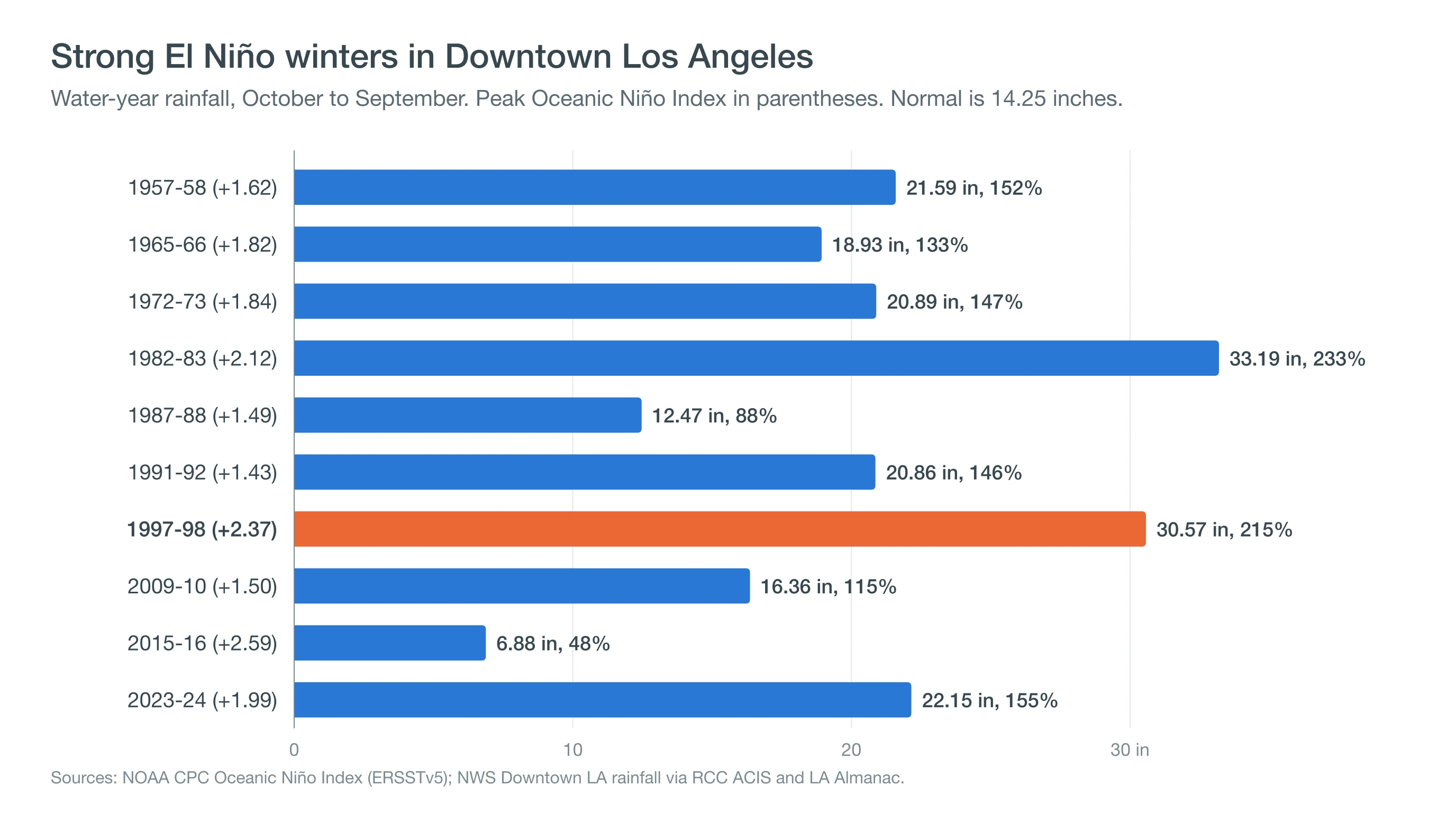
El Niño raises the odds of a wet winter but does not set the total. It makes a wet winter more likely and a very wet one possible, but where each storm lands is decided week by week.
Could 2026-27 Be Another 1997-98?
The 2026-27 winter could be another 1997-98, because the Pacific is even warmer now than it was then. NOAA's September 10, 2026 ENSO discussion puts the odds of a very strong El Niño above 90% and gives a 75% chance that it becomes the strongest since 1950 during October to December.
The weekly index has already passed every week of the 1997-98 and 2015-16 events, and El Niños usually peak between November and January. History says a wet winter is more likely than not, but 2015-16 shows it is not guaranteed. And a wet winter does not mean a wet New Year's: in 1982-83 and 1997-98, January 1 stayed dry Downtown, good news for the Rose Parade.
Los Angeles faces one new risk since 1998. The January 2025 Palisades and Eaton fires left burn scars above neighborhoods where heavy rain can trigger debris flows, which move faster and hit harder than the mudslides of 1998. If you live below a burn area or in a low-lying street, now is the time to clear gutters and storm drains, know your evacuation route, sign up for Alert LA County emergency notifications and read why LA floods so fast.
The winter of 1998 showed what a strong El Niño can bring when storms keep hitting Southern California: five waves of rain in a single month, flooded canyons and a record that still stands. This winter starts with an even warmer Pacific. Track each storm's rain timing and totals on our Los Angeles forecast pages, and follow National Weather Service flood watches and warnings for your neighborhood when the storms arrive.