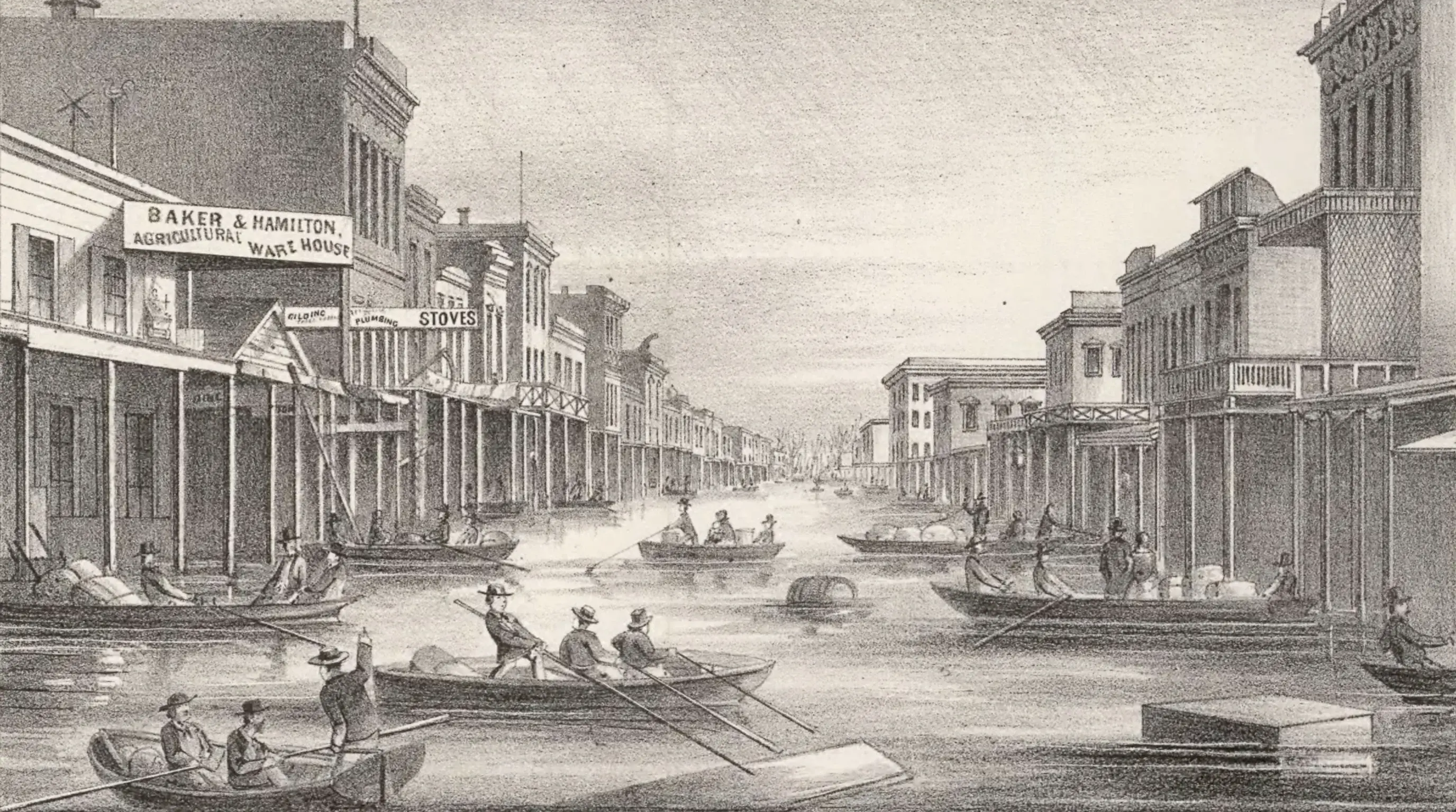
The Great Flood of 1862 began with rain on December 24, 1861, and in Los Angeles it fell almost without stopping until the morning of January 23, 1862. It sent the Los Angeles River over its banks, swept away the city's new water-works embankment, destroyed riverside vineyards, cut off the mail for weeks and pushed the San Gabriel River into a new channel near El Monte. Around Anaheim, the Santa Ana River spread for miles, and the settlement of Agua Mansa near present-day Riverside was nearly wiped out.
On Saturday, January 25, 1862, the Los Angeles Star summed it up in one sentence: the rain "commenced falling on the 24th of December, and continued, until the morning of the 23d January, with but two slight interruptions." The worst had come the previous Saturday, January 18, when "torrents of water were precipitated on the earth" and "it seemed as if the clouds had been broken through." No official rain gauge existed in Los Angeles yet, so what we know comes from the newspaper, ranch letters and the changed courses of the rivers.
| Question | Answer |
|---|---|
| When | Rain from December 24, 1861 to the morning of January 23, 1862, with two brief breaks |
| Official LA rainfall | Unknown; the city’s official gauge record starts in 1877 |
| Los Angeles | River over its banks, city water-works embankment swept away, vineyards lost, weeks without mail |
| San Gabriel River | Cut a new path from east to west of El Monte |
| Santa Ana River | Flooded miles on both sides; Anaheim inundated; Agua Mansa largely destroyed |
| Aftermath | Severe drought in 1863 and 1864 that helped end the rancho cattle era |
| Could it happen again? | Yes; geologic records show floods this large every century or two |
What Was the Great Flood of 1862?
The Great Flood of 1862 was the largest flood in California's written history. Over about 43 days that winter, storm after storm rolled in from the Pacific, a series that scientists now recognize as a string of atmospheric rivers. In the north, floodwater covered Sacramento, and the Central Valley filled into an inland sea roughly 300 miles long and 20 miles wide, according to paleoclimatologist B. Lynn Ingram.
The flood in Southern California is less well known, partly because no official measurements were taken. The Downtown Los Angeles weather record begins in July 1877, 15 years later. Rainfall totals for 1861-62 that circulate online, including 66 inches, are estimates, not measurements. The local record comes from reports of the damage.
What Happened in Los Angeles During the 1862 Flood?
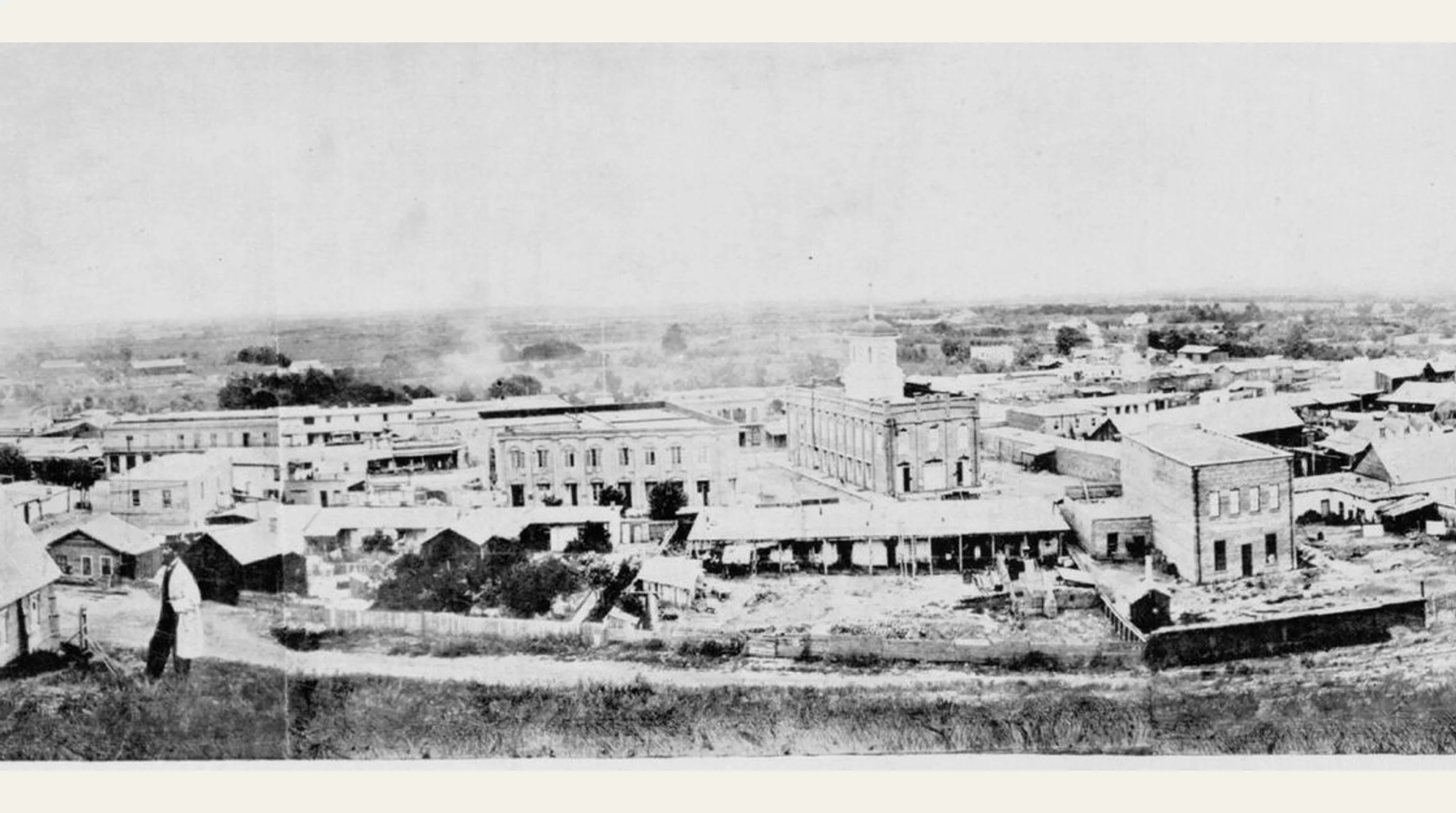
In Los Angeles, the 1862 flood sent the river through a town of about 4,400 people. By January 11 the Star described "an impromptu river along our streets." After the January 18 downpour, "rivers were formed in every gulch and arroyo," and the Los Angeles River, "already brimful, overflowed its banks, and became a fierce and destructive flood." The embankment the city had just built for its water works "was swept away, melted before the force of the water." The Arroyo Seco poured down its canyon into the river and drove the water "beyond all control."
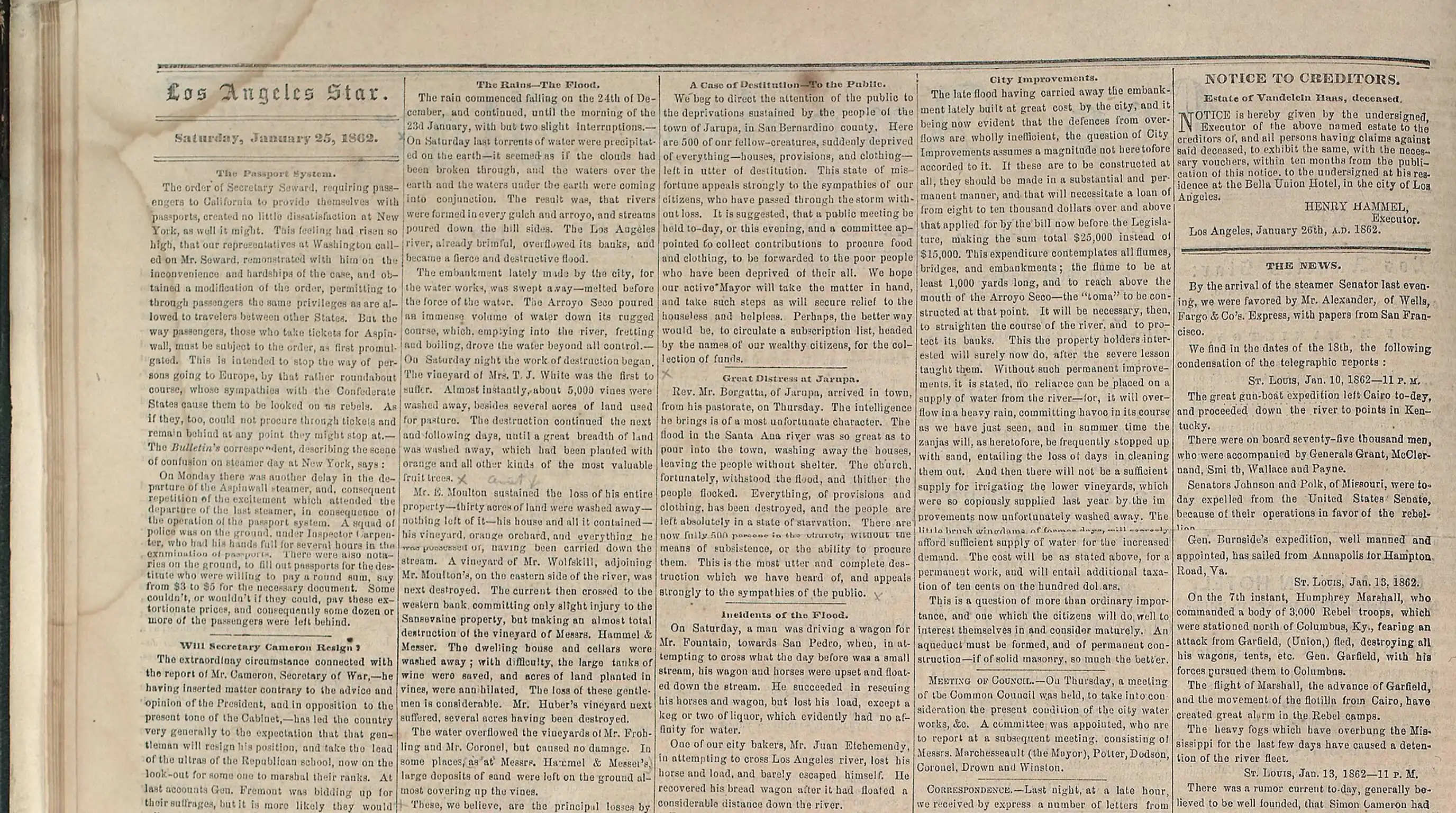
The vineyards along the river, the center of the town's economy, suffered the worst damage. At Mrs. T. J. White's vineyard, about 5,000 vines were washed away almost instantly. Elijah Moulton lost his house and about 30 acres of vineyard and orchard; William Wolfskill lost his vineyard on the east side of the river.
Upriver, houses on Jonathan R. Scott's ranch in what is now Glendale washed away, and Mission San Gabriel lost "four or five old adobes." By one estimate reported at the time, the riverside vineyards and orchards lost $25,000, a large sum for a small cattle town.
The flood also cut Los Angeles off. There were no bridges over the San Gabriel River, only fords, and by late January the town had gone about five weeks without deliveries of letters and packages. Travelers lost wagons and loads trying to cross; one local baker, Juan Etchemendy, lost his horse and bread wagon to the Los Angeles River and barely escaped himself. These accounts come from the Star, as compiled by the Homestead Museum and the paper's surviving pages.
How Did the Flood Move Rivers Across the LA Basin?
The 1862 flood moved rivers across the LA basin because, before concrete, Southern California's rivers wandered across the flat coastal plain and big floods cut new channels. In 1861-62 the San Gabriel River "forced a passage for itself, making its way from the eastward to the westward of El Monte," in the words of a contemporary account. Another flood in the winter of 1867-68 moved it again, carving the eastern channel the river follows today, and the older western channel became the Rio Hondo, which now joins the Los Angeles River.
Because the rivers kept shifting, the region's rivers now run in concrete. After more floods in 1914, 1934 and 1938, Los Angeles County and the Army Corps of Engineers confined the rivers to concrete channels behind a system of dams and debris basins. The channels hold the rivers in place, but they also make runoff arrive faster, as explained in why LA floods so fast.
What Happened to Anaheim and Agua Mansa?
The 1862 flood inundated Anaheim and nearly wiped out Agua Mansa. Anaheim, a German vineyard colony founded in 1857, was rumored in Los Angeles to have been completely destroyed.
Anaheim survived, but land for about four miles on either side of the Santa Ana River went under water, and Ingram describes an inland sea around Anaheim that stood for weeks. Upstream, the damage was worse. The New Mexican settlements of Agua Mansa and San Salvador, near today's Riverside, were nearly destroyed.
The Star relayed the news from the Jurupa area under the headline "Great Distress." The flood "was so great as to pour into the town, washing away the houses, leaving the people without shelter." The church withstood it, and people sheltered there. The paper appealed for aid for "500 of our fellow-creatures, suddenly deprived of everything, houses, provisions, and clothing." Agua Mansa never fully recovered; its hillside cemetery is much of what remains today.
Why Did a Flood Lead to a Drought That Ended the Rancho Era?
A flood led to a drought that ended the rancho era because Southern California's climate swings from one extreme to the other. Severe drought followed in 1863 and 1864, and the cattle that had survived the flood starved on dry range. William Workman, one of the region's leading rancheros, reportedly shot about 3,000 of his cattle to end their suffering. The ranchos lost much of their wealth with the herds, and much of their land passed to new owners over the following years.
The same pattern shows up in the modern record. Downtown Los Angeles got 31.07 inches in the wet winter of 2022-23, then 8.26 inches in 2024-25. Flood years and drought years often come back to back, as Los Angeles rainfall totals by year shows, and the difference between them is usually a few big storms.
Could a Flood Like 1862 Happen in Los Angeles Again?
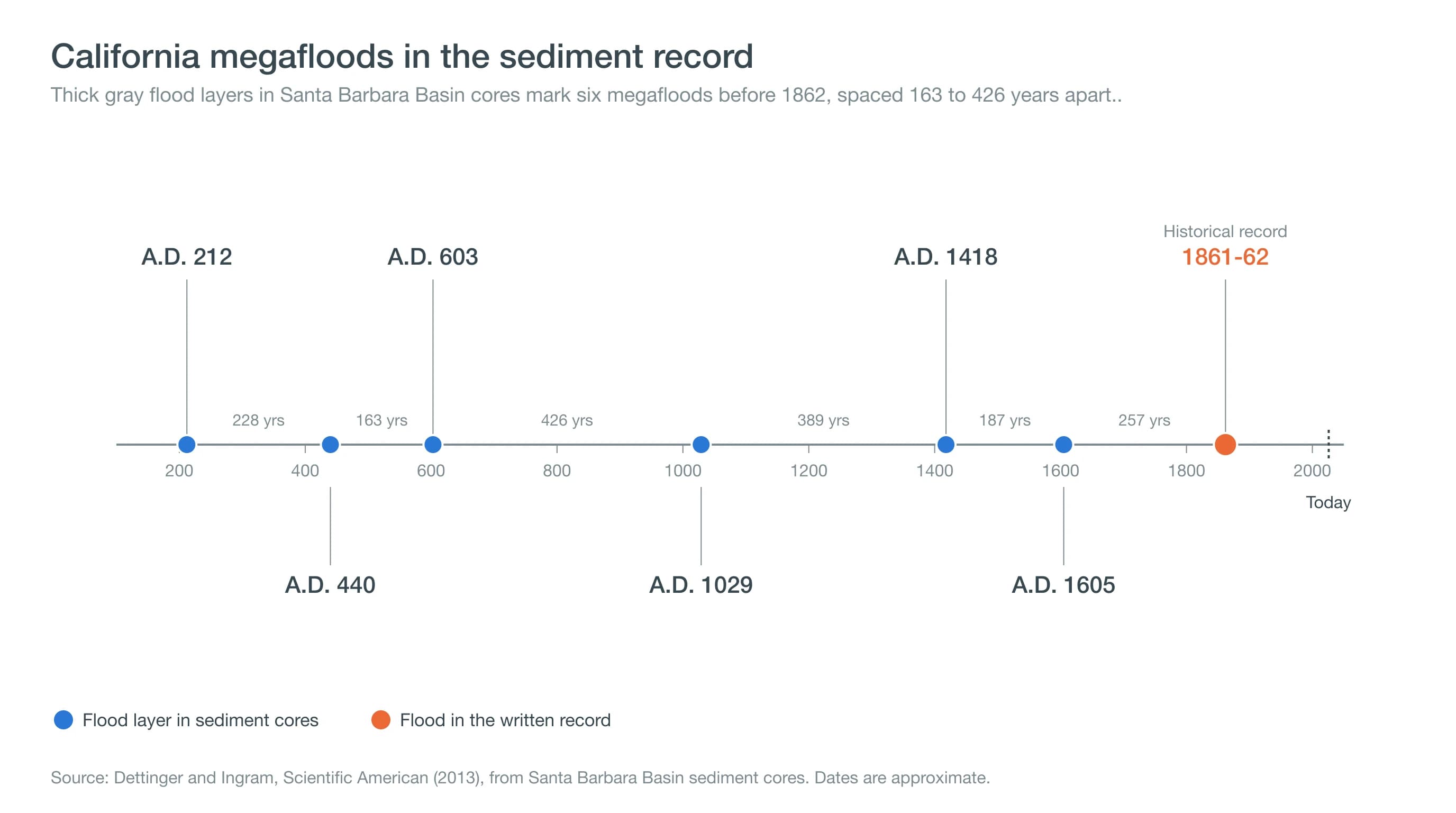
A flood like 1862 could happen in Los Angeles again, and scientists expect it will. Thick gray flood layers in sediment cores from the Santa Barbara Basin mark megafloods around A.D. 212, 440, 603, 1029, 1418 and 1605. Ingram writes that truly massive, rain-driven floods have struck California every 100 to 200 years.
The U.S. Geological Survey's ARkStorm scenario, modeled on 1861-62, estimated that a similar storm sequence today would cause about $725 billion in damage statewide.
The odds of another megaflood are rising. A 2022 study in Science Advances by Xingying Huang and Daniel Swain found that climate change has already roughly doubled the chance of a megaflood like 1862, because warmer air holds more water, so storms can drop more rain. Much would be different this time: dams, debris basins and concrete channels now guard the basin.
The stakes would be higher too, with millions of people living on the same plain the rivers once crossed. To see how exposed your own address is, start with Los Angeles flood risk maps, and for how long wet spells shape the region, see weather vs. climate in Southern California.
The Great Flood of 1862 shows that Los Angeles' mild reputation is based on averages. The rivers that now sit quietly in their channels once spread across the plain for weeks. When a strong storm is forecast, follow the National Weather Service and check rain totals for Downtown Los Angeles as it approaches.