floodingsafetysevere weathercity guide

Orange County Flash Floods: Canyons, Flats, Tides

By WeatherLA|Published |Last updated |7 min read
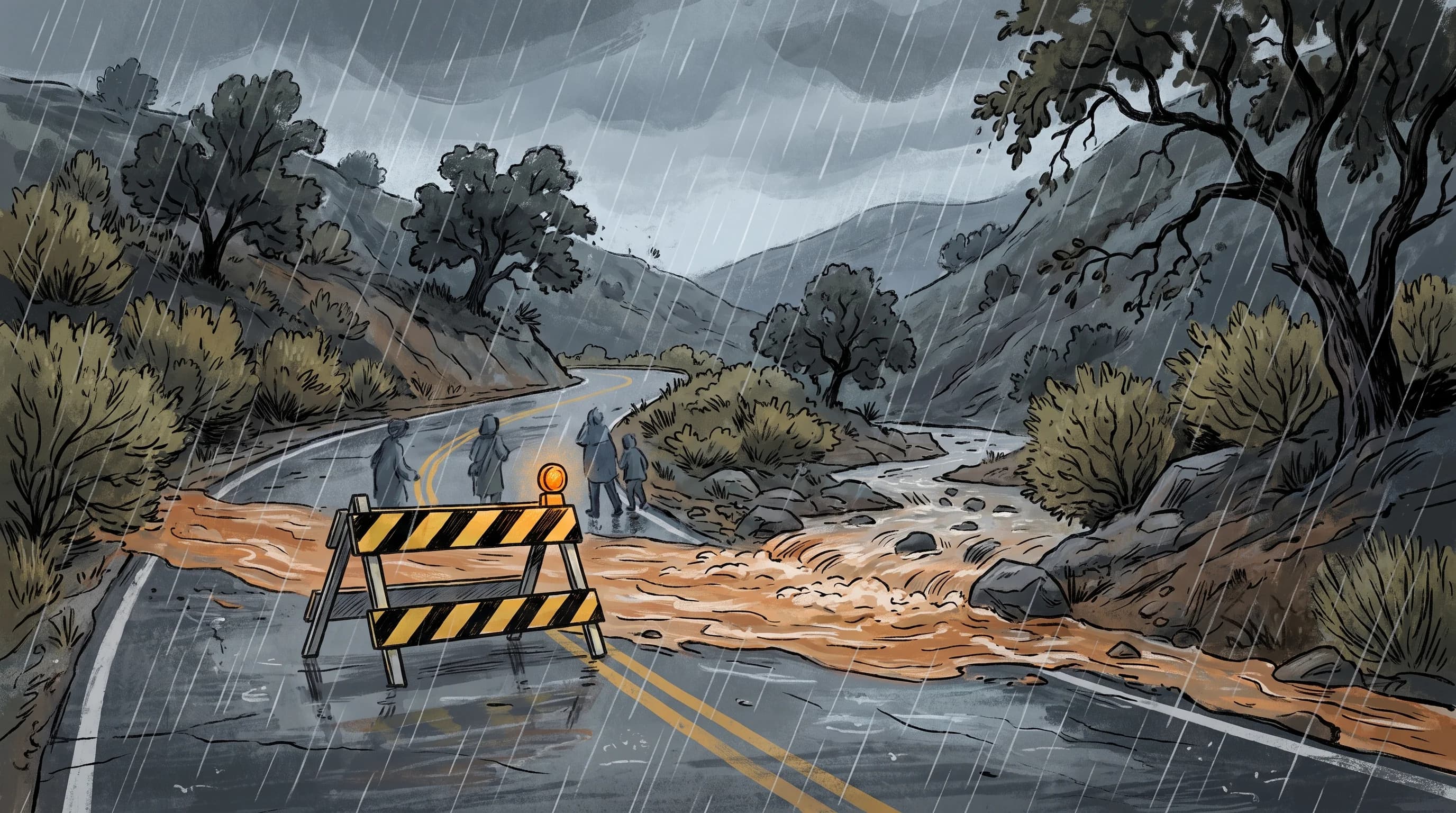
A wide Orange County storm scene moving from steep foothill canyon runoff through a flooded suburban creek to a closed low coastal street near the shoreline

Key Takeaways

  • Orange County does not have one flash-flood pattern; foothill canyons, flat urban neighborhoods, and low coastal streets each flood for a different physical reason.
  • Canyons below recent wildfire burn scars, tracked through county and Cal Fire mapping, can produce fast debris flows from storms that would be harmless on unburned slopes.
  • Flat inland cities flood from rain rate outrunning storm drain capacity, not from total rainfall, so a short, intense cell can flood streets that a longer, gentler storm never touches.
  • Coastal low spots near Newport Beach and similar shoreline communities face a compound risk when heavy rain coincides with high tide and elevated river-mouth levels, slowing drainage right when it is needed most.
  • The relevant flash-flood warning for most of Orange County comes from the NWS San Diego office, a different forecast office than the one covering Los Angeles and the San Gabriel Valley.
  • Never drive into a flooded street or wash; the same NWS guidance that applies across Southern California, not a lesser local exception, governs Orange County roads too.

Orange County does not flood one way. A steep foothill canyon near the Santa Ana Mountains can surge with a debris flow while a flat street in a paved suburb miles away floods from a storm drain that simply cannot keep up, and a low coastal block near Newport Beach can stay wet longest of all if high tide slows the drainage. The general mechanism behind fast flooding, intense rain overwhelming drainage or racing off terrain that cannot absorb it, is the same one covered for the whole basin in flash flooding in Los Angeles. What is different here is where and how that mechanism plays out across Orange County's three distinct landscapes.

Orange County's Three Flash-Flood Patterns
SettingPrimary triggerWhat to watch
Foothill canyons and burn scarsSteep terrain, scorched or thin soilDebris flows, sudden creek rises, road closures
Flat inland and suburban citiesRain rate exceeding storm drain capacityPonding at intersections and underpasses
Coastal low spots near Newport BeachRain plus high tide plus river-mouth levelSlower drainage, longer-lasting street flooding

Why does Orange County have more than one flash-flood pattern?

Orange County has more than one flash-flood pattern because its geography changes sharply from east to west. The county's northern and eastern edge rises quickly into the foothills of the Santa Ana Mountains, where small, steep watersheds can turn a heavy cell into fast runoff within minutes. The middle of the county is built out with flat, heavily paved cities where street flooding comes down to whether storm drains can keep pace with rain rate, not total rainfall.

Along the coast, low-lying neighborhoods near river mouths and back bays add a third variable that inland areas do not have: tide and ocean water level. A single storm moving across the county can trigger all three patterns in the same afternoon, which is why one countywide flood outlook rarely applies evenly everywhere.

How do canyons and burn scars focus runoff?

Canyons focus runoff by funneling rain from a small, steep watershed down toward a single road or creek crossing, so water that falls across a wide hillside arrives concentrated at one narrow point. That effect is far more dangerous below a recent wildfire burn scar, where fire has removed vegetation and altered the soil surface so it repels water instead of absorbing it. Rain that would normally soak into unburned ground instead sheets off fast, carrying ash, mud, and rock with it, a hazard the USGS Landslide Hazards Program studies specifically because burned watersheds can produce debris flows from storms that would be minor on unburned slopes.

Orange County and Cal Fire mapping identifies which canyons sit below active burn scars in a given year, and that mapping, not a generic canyon-road assumption, is what should guide whether a specific route is a debris-flow risk during a storm.

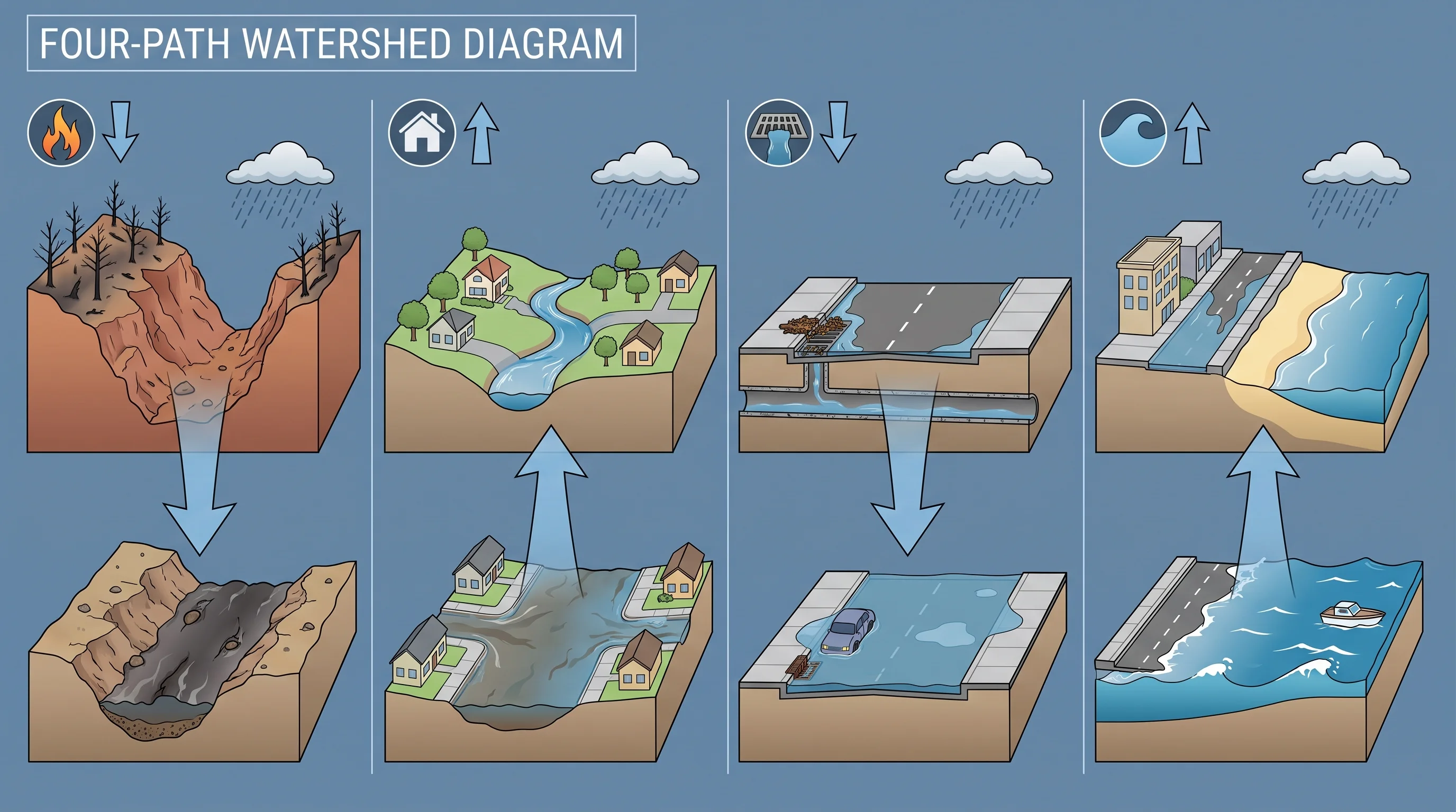
A four-path watershed diagram comparing burn-scar canyon runoff, a rising suburban creek, an overloaded urban storm drain, and tide-influenced coastal street ponding
Orange County's flash-flood risk is not one hazard. Burn-scar canyons, flat urban drainage, and coastal low spots each respond to the same storm in a different way.

Why can inland streets flood under a small storm cell?

Inland streets can flood under a small storm cell because street flooding depends on rain rate, not on how large or long-lasting the storm is overall. A brief, intense cell can drop rain faster than curb inlets and underground storm drains are sized to carry it away, so water ponds at low intersections and underpasses even after the cell has moved on. Fully paved neighborhoods make this worse because pavement absorbs essentially none of the rain that falls on it, sending nearly all of it into the drainage system at once.

A single block's flooding can also reflect runoff arriving from higher ground upstream, not just rain falling directly overhead, which is why a street can flood even during a lull in local rainfall. Cities across the flat parts of the county size their storm drains for typical events, and an unusually intense cell, even a short one, can exceed that design capacity.

When do coastal low spots face a compound problem?

Coastal low spots face a compound problem only when heavy rain coincides with high tide and an elevated river or creek mouth level at the same time. Under normal conditions, storm drains and creeks near the shoreline empty into the ocean without much resistance. When high tide raises ocean water level at the same time a storm is pushing rain toward the coast, the outfall has less room to drain into, so water backs up into nearby streets and stays longer than it would inland.

This applies specifically to low-lying neighborhoods near river mouths and back bays, including areas around Newport Beach, rather than to every coastal block in the county, and it only becomes a real compound hazard when all three factors, rain, tide, and river-mouth level, line up rather than when just one of them is elevated on its own.

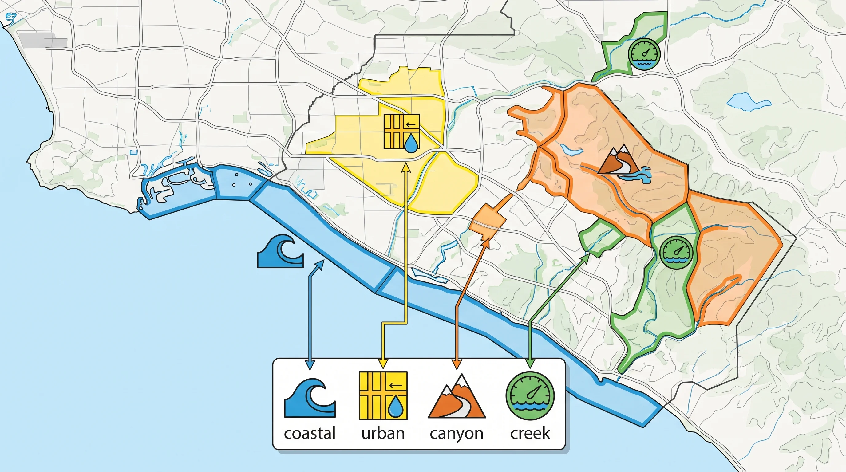
An Orange County alert map aligning NWS San Diego warning polygons with canyon road closures, creek gauge markers, city street notices, and coastal flood advisory zones
Matching the right alert to the right part of Orange County means checking NWS San Diego's warning polygon alongside canyon closures, creek gauges, and coastal advisories for your specific area.

Which alert applies to your part of Orange County?

Most of Orange County falls under the National Weather Service San Diego office, a different forecast office than NWS Los Angeles/Oxnard, which covers the LA Basin and San Gabriel Valley to the north. A Flash Flood Warning from NWS San Diego tells you the hazard is possible somewhere within its polygon, but it does not by itself tell you which canyon road is closed, which creek gauge is rising, or which coastal street has standing water.

That level of detail comes from county and city sources: Orange County Public Works for flood-control channel and creek information, local city notices for specific street and underpass closures, and burn-area advisories from the county or Cal Fire when a recent fire is relevant. Checking the NWS warning and the local road or closure source together, rather than either alone, is what actually tells you whether your specific route is affected. General guidance on reading these products is covered by NWS flood safety and the Weather Prediction Center, which tracks the broader storm systems that reach Southern California before local offices issue warnings.

How should canyon drivers and coastal residents respond?

Canyon drivers and coastal residents need different decisions because they face different risks. On a narrow canyon road below a burn scar, the right move is to leave early, before the heaviest rain arrives, since these roads can close quickly and often have few alternate routes once water or debris covers the pavement. Never drive around a barricade on a canyon road; county closures in these areas are tied to specific rainfall and debris- flow thresholds, not general caution. In flat suburban neighborhoods, avoid driving through any flooded intersection or underpass, since depth is hard to judge from inside a vehicle and standing water can hide a stalled car or an open manhole.

Along the coast near low- lying streets, check whether heavy rain is coinciding with high tide before assuming a street that was passable an hour ago still is, since compound coastal flooding can develop and recede on a different schedule than inland street flooding. In every setting, the same rule applies: never drive or walk into moving water, a principle covered in more general terms in flash flooding in Los Angeles and in flood vs. flash flood, which explains how these hazards are officially defined and warned for across the region.

Orange County's flood risk is really three separate stories happening under one county name, and the best local reference should match the pattern in your own neighborhood, not a generic regional description. If your drive touches a foothill canyon, a flat suburban grid, and a low coastal street in the same trip, as many Orange County commutes do, check conditions for all three before you leave, not just the one closest to home. Compare current conditions near Newport Beach and other Orange County destinations on WeatherEscape, and see how this same fast-flooding mechanism plays out farther north in Long Beach before you plan a storm-day route across the region.

Frequently Asked Questions

Why does Orange County have more than one flash-flood pattern?

Orange County spans steep foothill canyons along its northern and eastern edge, flat, heavily paved suburban cities across the middle of the county, and low-lying coastal terrain where creeks and rivers meet the ocean. Each setting reacts to heavy rain differently: canyons concentrate runoff fast, flat cities flood when a short burst of rain outpaces storm drains, and coastal low spots can back up when high tide or an elevated river mouth slows drainage during the same storm.

How do canyons and burn scars focus runoff?

Foothill canyons drain small, steep watersheds that funnel rain toward a single road or creek crossing within minutes, and that effect gets far worse below a recent wildfire burn scar, where scorched soil sheds water and loose material instead of absorbing it. The result can be a debris flow, a fast-moving slurry of mud, rock, and vegetation, triggered by rain totals that would do little on unburned terrain, which is why burn areas get their own USGS landslide hazard assessments and county closure decisions after a fire.

Why can inland streets flood under a small storm cell?

Street flooding in flat Orange County cities usually comes down to rain rate, not storm size. A brief, intense cell can drop rain faster than curb inlets and underground storm drains can carry it away, so water ponds at intersections and underpasses even when the storm covers a small area and passes quickly. Pavement that cannot absorb any of the rain, plus runoff arriving from upstream neighborhoods, adds to what a single block's own drains have to handle.

When do coastal low spots face a compound problem?

Coastal low spots face a compound problem only when heavy rain, high tide, and an elevated river or creek mouth level line up at the same time. High tide and wave run-up can slow how fast a swollen creek or storm drain outfall can empty into the ocean, so water that would normally drain within hours can back up into nearby streets for longer. This applies mainly to low-lying shoreline neighborhoods near river mouths and back bays, not to every coastal block in the county.

Which alert applies to your part of Orange County?

Most of Orange County falls under the National Weather Service San Diego forecast office, a different office than the one that covers Los Angeles and the San Gabriel Valley, so the correct warning polygon to watch is the one issued by NWS San Diego for your specific area. Pair that warning with county and city sources for canyon road closures, creek gauge readings, and any evacuation guidance tied to a burn scar, since the NWS product tells you the hazard is possible while local agencies tell you which specific roads are affected.

How do burn scars and urban runoff change Orange County's flash-flood risk?

Burn scars remove the vegetation and soil structure that would normally slow and absorb rain, turning moderate storms into fast debris-flow triggers on the specific slopes and canyons below the burned area, an effect that typically lasts for a few years after a fire until vegetation recovers. Urban runoff has the opposite mechanism but a similar result: pavement and roofs across a built-out city shed nearly all the rain that falls on them, so peak flows in storm drains and channels arrive faster and higher than they would from the same rain falling on open ground.

Why can Orange County's flood-control channels fill so quickly during intense rain?

Flood-control channels are engineered to move water quickly, which means they respond almost immediately to rain falling anywhere in their upstream watershed, not just rain falling where you are standing. A channel that looks empty can rise within minutes if an intense cell is hitting the foothills above it, which is why these channels should be treated as fast-changing hazards rather than fixed, predictable waterways, even on a day when it is not raining at your exact location.

Related Destinations

Live Los Angeles Conditions

Compare temperature, wind, clouds, and comfort across the map.

See which microclimates are clear, cool, windy, smoky, or warming up right now.

Open the Weather Map
Destinations☀️Smog Forecast🌫️Smog Heat Map🔒Privacy Policy📄Terms of Service