floodingsafetycity guiderainfall

Why Long Beach Floods Fast: Flat Streets, High Tide

By WeatherLA|Published |Last updated |9 min read
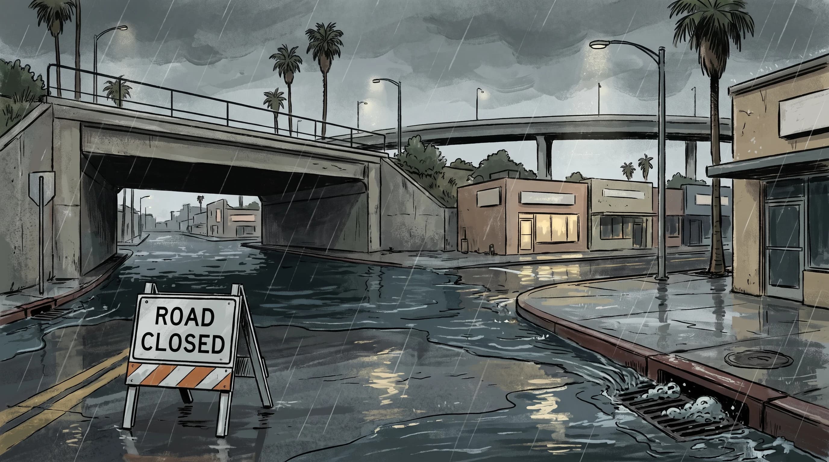
A rain-soaked Long Beach streetscape with water pooling at a closed underpass while storm drains flow and the harbor remains visible in the background

Key Takeaways

  • Long Beach floods from drainage capacity, not steep terrain; flat ground and near-total pavement mean rain has almost nowhere to go but the storm drain network beneath the street.
  • The Los Angeles River and San Gabriel River both reach the coast near Long Beach, carrying runoff from watersheds many miles inland, separate from the neighborhood storm drains that respond only to local rainfall.
  • A high tide or elevated harbor water level does not cause a rain flood, but it can slow how fast storm drains and river outlets empty, leaving standing water longer.
  • Underpasses and low streets pond first and drain last because they sit below the surrounding grade, and standing water can hide displaced covers, debris, and true depth.
  • Flood Advisory, Flash Flood Warning, and Coastal Flood are three distinct NWS products that can all apply to Long Beach in the same storm, each with a different required action.
  • The NWS Turn Around Don't Drown rule applies in Long Beach exactly as it does anywhere else: roughly six inches of moving water can stall a car, and about two feet can float one.

Long Beach floods fast in heavy rain because it is flat, low, and built almost entirely on pavement, so runoff has nowhere to soak in and nowhere to fall before it reaches a street. Unlike the steep foothill neighborhoods elsewhere in the county, Long Beach's flash-flood risk comes from drainage capacity rather than mountain terrain, and it gets a second complication that inland areas do not: a high tide or elevated harbor water level can slow how quickly storm drains empty, backing water up into streets even after the rain itself eases. The mechanics of why intense rain overwhelms drainage anywhere in the basin are covered in flash flooding in Los Angeles; this article stays local to what changes at sea level in Long Beach.

Why can heavy rain overwhelm flat, coastal Long Beach?

Flat terrain removes the one thing that normally moves floodwater along quickly: slope. Most of Long Beach sits at or just above sea level with very little natural grade, so rain that falls on streets, parking lots, and rooftops has to rely almost entirely on the underground storm drain network to get anywhere, rather than partly draining downhill the way runoff does in a hillside neighborhood. Pavement covers nearly all of that ground, which means almost none of the rain infiltrates into soil the way it would on an undeveloped lot, so a heavy cell can turn a dry intersection into standing water within minutes once the rain rate outpaces what the drains beneath it can carry away.

Low points compound the problem. Streets, underpasses, and older neighborhoods built before modern stormwater standards often sit in shallow depressions that were never graded to drain quickly, so they collect runoff from the surrounding blocks in addition to their own rainfall. The result is a pattern familiar to longtime residents: some intersections pond in almost every heavy storm while streets a few blocks away, sitting only slightly higher, stay dry. This is a drainage-capacity problem rather than a river-flooding problem, which is also why it can develop and recede faster than a flood driven by a swollen river channel.

How do the LA River, San Gabriel River, and storm drains differ?

The Los Angeles River and San Gabriel River are large, engineered flood control channels that carry water from mountain and valley watersheds many miles upstream, while Long Beach's neighborhood storm drains are a separate, much smaller system built to move rainfall off local streets into those larger channels or directly to the harbor. Both rivers reach the coast near Long Beach, the Los Angeles River discharging into the harbor area and the San Gabriel River reaching the ocean near the Long Beach and Seal Beach line, so the city sits at the outlet of two regional watersheds in addition to managing its own local rainfall.

That distinction matters for what a resident should expect during a storm. Regional river channel flow depends on how much rain fell across the San Gabriel Mountains and inland valleys hours earlier, and is tracked separately from the neighborhood drains that only respond to rain falling directly over Long Beach. A street can flood from a purely local downpour with no connection to river levels at all, while a different, low-lying area near a river mouth can see elevated water tied to conditions far upstream. Neither the city nor the National Weather Service treats these as the same hazard, which is why official guidance from the NWS Los Angeles/Oxnard office separates river and channel flood products from the urban and small stream flood advisories that cover street-level ponding.

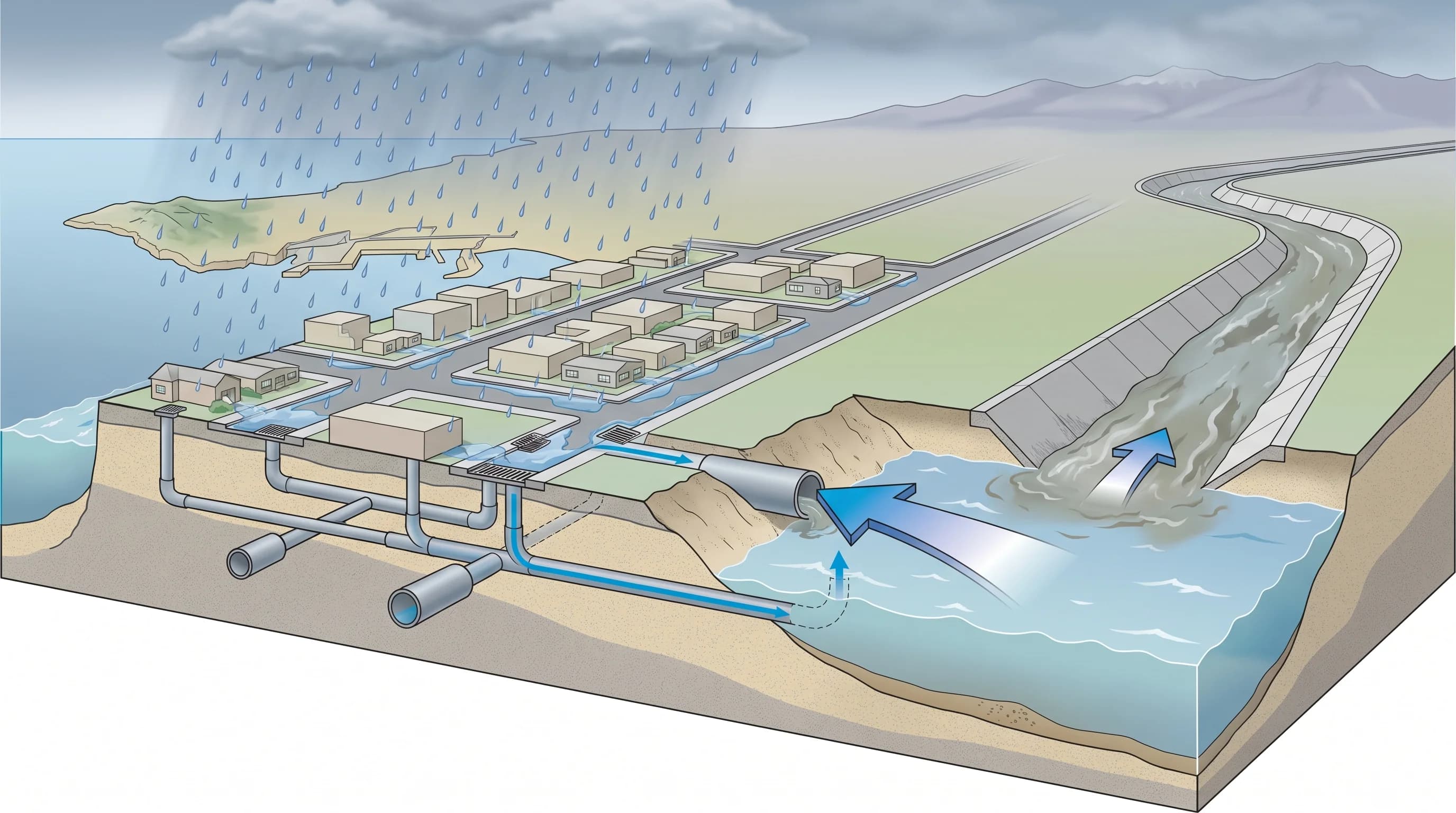
Cutaway illustration separating a Long Beach neighborhood storm drain line from the larger Los Angeles and San Gabriel River flood control channels, with an arrow showing elevated harbor water slowing the outflow point where drains empty near the coast
Long Beach's flood risk has two separate layers: local storm drains that respond only to rain falling directly overhead, and the LA and San Gabriel River channels that carry runoff from watersheds many miles inland, with both outlets sensitive to how high the coastal water sits when they empty.

Can high tide make a rain flood worse?

High tide does not create a rain flood, but it can make one linger longer by slowing how fast storm drains and river outlets empty into the ocean and harbor. Storm drains and flood control channels rely on a level difference, water flows toward the lowest available point, so when the tide or harbor water level is elevated at the outlet, that outflow point rises too and the whole system has less room to drain into. A downpour that coincides with a high tide can leave standing water in low streets and parking lots noticeably longer than the same rainfall would during a low tide, even though the rain itself was identical.

This coastal backup effect is a known factor in flat, low-lying coastal cities generally, and it is one of the reasons the National Weather Service issues separate coastal flood products alongside ordinary flood advisories, rather than relying on a single alert for every kind of water. Residents near the harbor, the Los Angeles River mouth, or other low-lying shoreline areas should treat a forecast combining heavy rain with an elevated tide as a longer-duration flood risk than the rain forecast alone would suggest, and check official coastal flood guidance rather than assuming the water will recede as quickly as a typical inland storm.

Why are underpasses and low streets so dangerous?

Underpasses and low streets are dangerous because they hide how deep the water actually is and because they pond faster than the streets around them. A road that dips beneath a rail line or freeway sits below the surrounding grade by design, so it is always the last place to drain and one of the first to fill once rain outpaces the local storm drains. Drivers approaching from street level often cannot judge the true depth until they are already in it, since a foot or more of water can look like a shallow puddle reflecting headlights or streetlights at night.

Moving or standing water in these low points can also hide displaced manhole covers, storm drain grates lifted by pressure, and debris carried in from surrounding streets, none of which are visible from a driver's seat. A stalled vehicle in a flooded underpass is not just inconvenient; it blocks the point where water is deepest and can leave occupants stranded as water continues to rise around a car that will not restart. This is the same core hazard described in NWS flood safety guidance for any urban area, and it is one of the clearest reasons the agency's driving advice makes no exception for a street a driver knows well.

Which alert applies to Long Beach urban flooding?

Three separate National Weather Service products can apply to Long Beach during the same storm, and each means something different. A Flood Advisory signals that rain is expected to cause minor, generally non-life-threatening flooding such as ponding on streets and in parking lots, useful for planning a route but not an emergency on its own. A Flash Flood Warning is more urgent and means rainfall rates are expected to or already are producing rapid, dangerous flooding, the kind that can fill a low street or underpass in minutes and requires immediate action rather than monitoring.

A Coastal Flood product, separate from both, addresses elevated ocean or harbor water levels tied to tide, surge, or swell rather than rainfall, though as covered above, an active coastal flood situation can slow drainage during a rain event happening at the same time.

Knowing which product is active tells a Long Beach resident what kind of water to expect and how much time they have. An Advisory means watch for standing water and plan around it; a Warning means treat the situation as an immediate hazard and avoid driving through low-lying streets altogether; a Coastal Flood product means the shoreline and harbor- adjacent areas need separate attention even if the rain forecast alone looks modest. All three are issued and updated by the NWS Los Angeles/Oxnard office, which covers Long Beach and the surrounding harbor area.

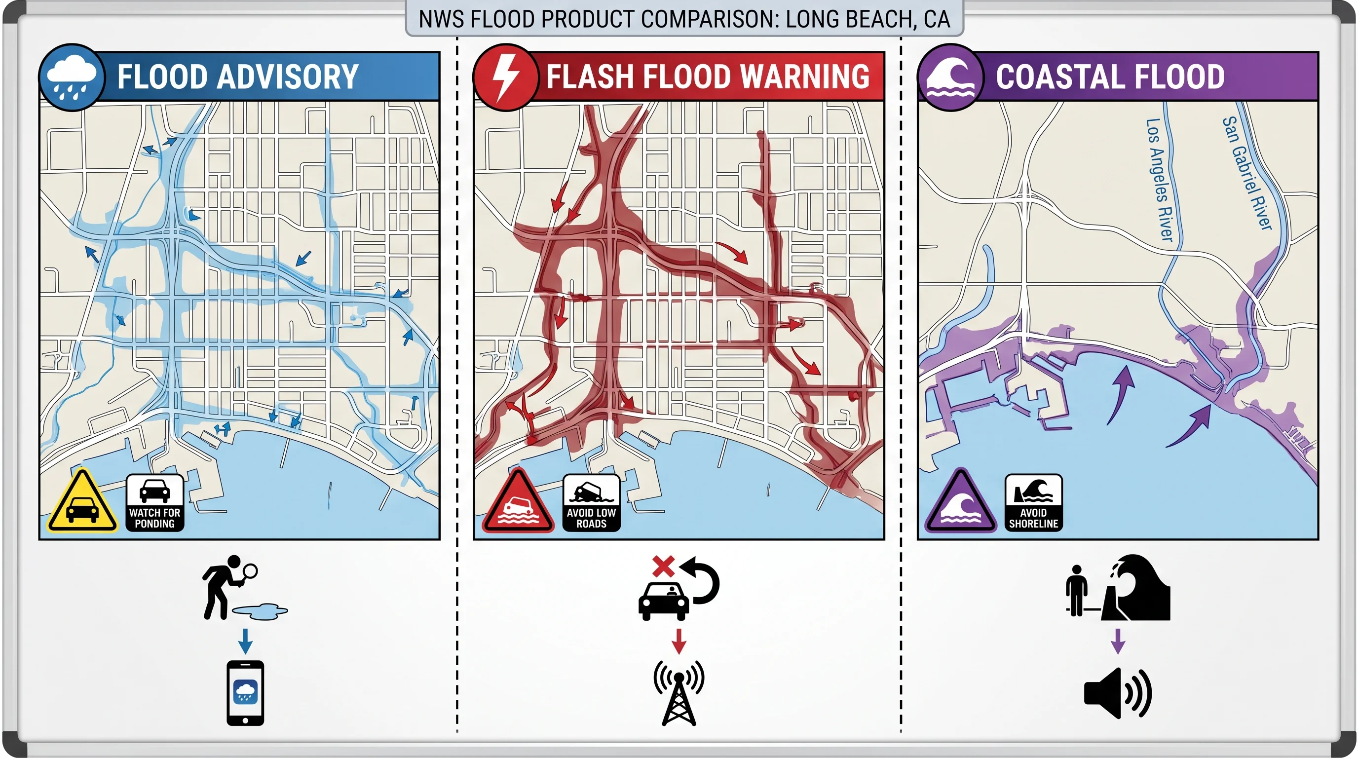
A reference graphic comparing Flood Advisory, Flash Flood Warning, and Coastal Flood alert products against Long Beach streets, the LA and San Gabriel River outlets, and the shoreline, with a short recommended action listed under each alert type
Long Beach can see three different NWS flood products in a single storm, and each points to a different action, from watching for street ponding under a Flood Advisory to avoiding low roads entirely under a Flash Flood Warning.

What should drivers and shoreline visitors do?

Drivers should never enter a flooded street or underpass, regardless of how familiar the route is or how shallow the water looks. The NWS flood safety guidance puts the driving depth thresholds in concrete terms: roughly six inches of moving water can stall a passenger car, and about two feet can float most vehicles off the roadway entirely. Before driving anywhere in Long Beach during heavy rain, check the city's street closure list, the active NWS warning polygon for the area, and whether any underpass on the planned route has a history of flooding, since a route that looks clear on a general map can still cross one of the low points that floods first.

Shoreline visitors need a separate rule. Near the beach, the breakwater, and the harbor, stay well back from seawalls, jetties, and low-lying parking areas during an active Coastal Flood product or a high surf advisory, since wave runup and elevated water can reach farther inland than it appears from a distance. Combining a rain forecast with the tide chart before heading to the shoreline is worth the extra step, since the two hazards do not always peak at the same time.

For the wider mechanism behind why Southern California storms behave this way at all, see flash flooding in Los Angeles, and for how the same basic pattern plays out elsewhere in the region, see flash flooding in Orange County and flash flooding in Palm Springs, where desert washes replace storm drains as the dominant local hazard.

Long Beach's flood risk is manageable once you know what to watch: local drainage capacity for street-level ponding, river and channel conditions for the LA and San Gabriel River outlets, and tide levels for how fast the coast can drain during a storm. Before driving or heading to the shoreline in heavy rain, check WeatherEscape's current conditions for Long Beach, confirm the active NWS warning polygon and any coastal flood product, and verify street and underpass closures with the city rather than assuming last storm's conditions still apply.

Frequently Asked Questions

Why can heavy rain overwhelm flat, coastal Long Beach?

Long Beach sits at or just above sea level with very little natural slope, so rain cannot partly drain downhill the way it does in hillside neighborhoods elsewhere in Los Angeles County. Nearly the entire city is paved, which blocks infiltration into soil, so runoff depends almost completely on the underground storm drain network. When rainfall rate exceeds what that network can carry, low streets and intersections pond within minutes.

How do the LA River, San Gabriel River, and storm drains differ?

The Los Angeles River and San Gabriel River are large flood control channels carrying runoff from mountain and valley watersheds many miles upstream, both reaching the coast near Long Beach. Neighborhood storm drains are a separate, smaller system that only responds to rain falling directly over Long Beach streets. A local downpour can flood a street with no connection to river levels, while a different low-lying area near a river mouth can see elevated water tied to conditions far inland.

Can high tide make a rain flood worse?

High tide does not create a rain flood, but it can make one last longer. Storm drains and river outlets rely on a level difference to empty into the ocean and harbor, so when the tide or harbor water is elevated at the outlet, the whole system has less room to drain into. A downpour that coincides with a high tide can leave standing water in low streets noticeably longer than the same rain would during a low tide.

Why are underpasses and low streets so dangerous?

Underpasses and low streets sit below the surrounding grade, so they pond first and drain last during any heavy storm. Standing water there can hide true depth, displaced manhole covers, lifted storm drain grates, and debris that a driver cannot see from behind the wheel. A stalled vehicle in a flooded underpass blocks the deepest point and can leave occupants stranded as water continues to rise.

Which alert applies to Long Beach urban flooding?

Three separate NWS products can apply: a Flood Advisory for minor, generally non-life-threatening ponding on streets and lots; a Flash Flood Warning for rapid, dangerous flooding that can fill a low street or underpass within minutes; and a Coastal Flood product for elevated ocean or harbor water tied to tide, surge, or swell rather than rainfall. All three are issued by the NWS Los Angeles/Oxnard office, and more than one can be active at once during the same storm.

What should drivers do in Long Beach during heavy rain?

Never drive through a flooded street or underpass, no matter how familiar the route. Per NWS flood safety guidance, roughly six inches of moving water can stall a passenger car and about two feet can float most vehicles off the roadway. Before heading out, check the city street closure list, the active NWS warning polygon, and whether any underpass on the route has a history of flooding.

Is it safe to visit the Long Beach shoreline during a storm?

Not during an active Coastal Flood product or high surf advisory. Stay well back from seawalls, jetties, and low-lying parking areas near the beach and harbor, since wave runup and elevated water can reach farther inland than they appear from a distance. Checking both the rain forecast and the tide chart before heading to the shoreline matters because the two hazards do not always peak at the same time.

Related Destinations

Live Los Angeles Conditions

Compare temperature, wind, clouds, and comfort across the map.

See which microclimates are clear, cool, windy, smoky, or warming up right now.

Open the Weather Map
Destinations☀️Smog Forecast🌫️Smog Heat Map🔒Privacy Policy📄Terms of Service