beach weathersafetyphenomenaclimate scienceflooding

Malibu's Points and Coves Turn One Swell Into Two Risks

By WeatherLA|Published |Last updated |10 min read
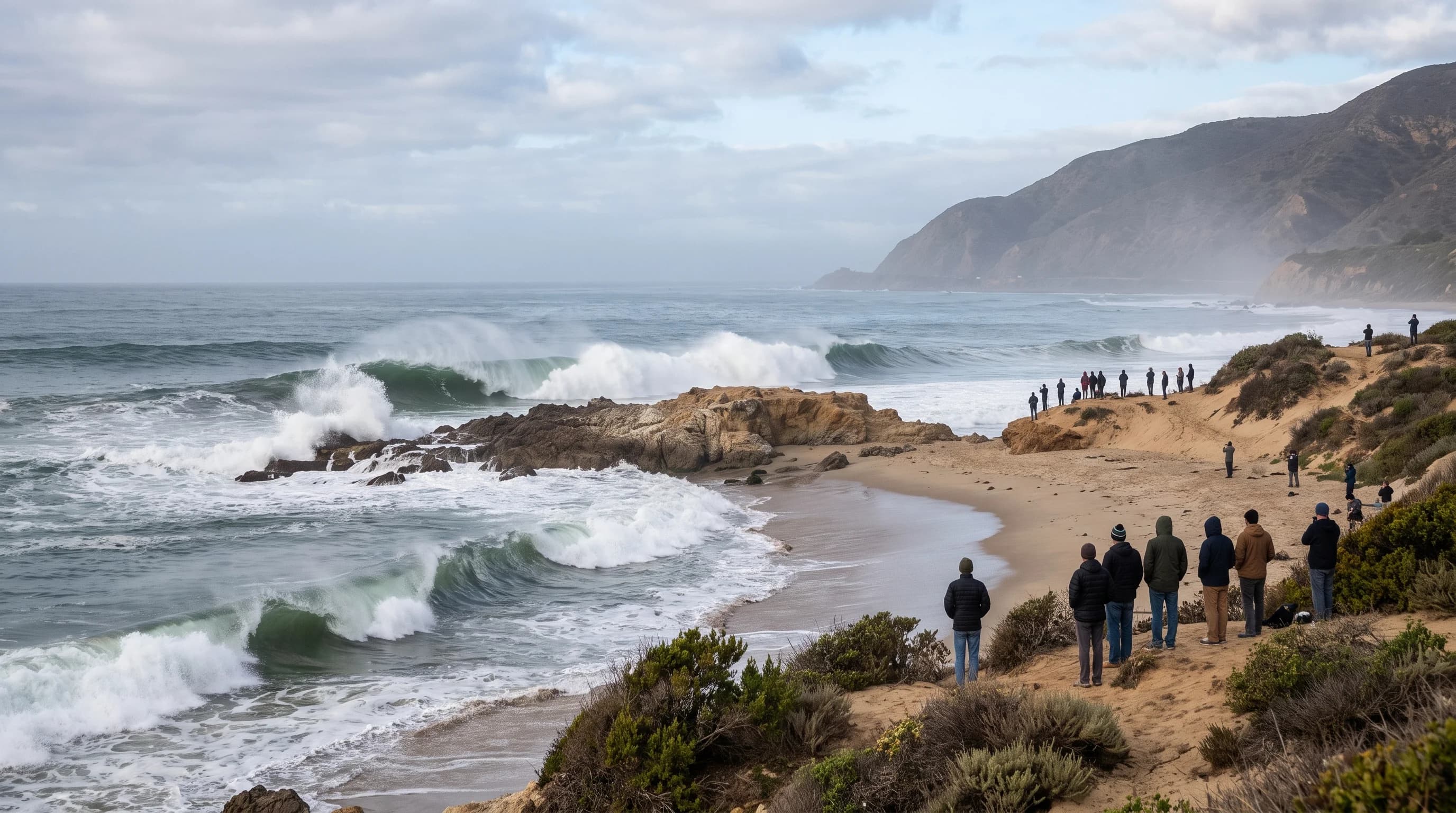
A long-period swell wrapping around a Malibu point into a rocky cove, with a narrow beach and safe observation distance emphasizing run-up and limited escape space

Key Takeaways

  • Malibu's coastline faces south and southwest rather than straight into the prevailing northwest swell, which makes it unusually sensitive to south swell that many other LA County beaches barely notice.
  • Points and headlands like Point Dume refract and focus incoming swell onto some beaches while sheltering coves just around the corner, so two Malibu beaches a mile apart can see very different surf from the same storm.
  • Wave period matters as much as height: a long-period swell of 15 to 20 seconds carries far more energy to the Malibu shoreline and breaks with more force than a shorter-period swell of the same offshore height.
  • Cliffs, rocks, and narrow beaches raise the danger because they shrink the dry-sand buffer, and a route that was dry on the walk out can be cut off by a later wave in the same set.
  • A High Surf Advisory or Warning covers breaking-wave danger in the surf zone, while a Coastal Flood Advisory or Warning covers wave run-up and tide-driven flooding on roads and parking areas, including sections of Pacific Coast Highway; the two often arrive together but are not the same hazard.
  • Before visiting, check the current NWS surf zone forecast, tide stage from NOAA Tides and Currents, active lifeguard closures, water quality advisories, and PCH road status together, since no single number tells the whole story.

Malibu turns a distant Pacific storm into a local hazard more efficiently than almost any other stretch of the Los Angeles coast. The same 27-mile shoreline that gives Malibu its famous point breaks also means long-period swell arrives here at close to full strength, focused by points and submarine contours rather than spread evenly across a flat beach. A swell that looks modest on an offshore buoy can break with real force at Point Dume or Zuma Beach, and during the biggest events, wave run-up has closed lanes of Pacific Coast Highway itself.

This article covers the mechanism specific to Malibu: how swell direction and coastal geography interact, why cliffs and narrow beaches raise the stakes, which storm tracks matter, and what to check before a visit. For the hazard mechanics of a rip current, sneaker wave, or rogue wave, see the dedicated articles linked throughout; this page focuses on why Malibu itself turns dangerous.

What makes surf "high" in Malibu?

Surf counts as high in Malibu when breaking wave faces reach a level the National Weather Service Los Angeles/Oxnard office judges hazardous to people on or near the beach, not a subjective read on how good the waves look for surfing. NWS issues High Surf products by coastal zone, and the Malibu coastline sits in a zone that regularly sees some of the largest breaking waves in Los Angeles County because of how exposed it is to open-ocean swell. The forecast threshold is about breaking wave face height at the shoreline, not the height recorded by an offshore buoy, since a wave grows as it feels the shallowing seafloor near the coast.

Wave period, the number of seconds between successive crests, matters as much as height. A short-period wind swell with a 6 to 8 second period carries far less energy than a long-period swell with a 16 to 20 second period, even when both read the same height on a buoy. Long-period swell is generated by strong, distant storms and loses relatively little energy crossing the open Pacific, so it arrives at Malibu as a dense, powerful wave that breaks with a hard, sudden release of force. That is why a forecast describing "12 feet at 18 seconds" is a bigger local hazard than "12 feet at 9 seconds," even though the height number is identical.

How do swell direction and Malibu's coastline interact?

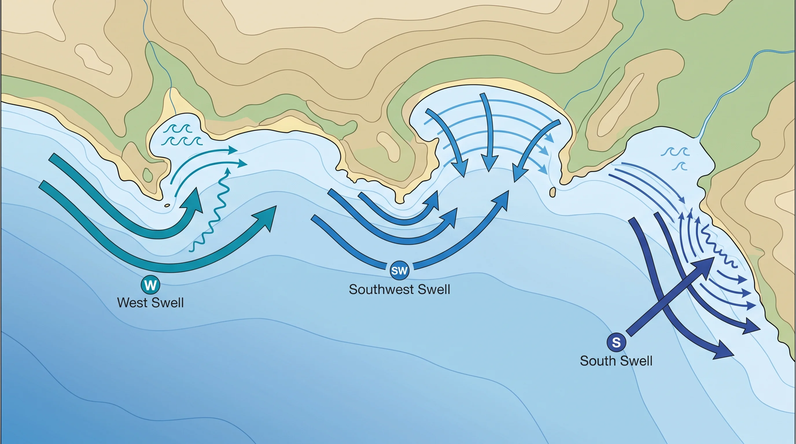
Malibu's coastline runs roughly east to west, which means it faces south and southwest toward the open Pacific rather than directly into the prevailing northwest swell that pounds much of the rest of the Southern California coast. That orientation makes Malibu unusually sensitive to south and southwest swell, sources that many other LA County beaches barely feel, while points along the coast still catch a meaningful share of northwest energy that wraps and refracts around the shoreline's bends. Wave energy does not distribute evenly along this stretch. As swell approaches from deep water, it slows and bends, or refracts, around points and headlands like Point Dume, concentrating energy on some stretches of sand while sheltering coves just around the corner from the same swell.

This is why two Malibu beaches a mile apart can look completely different on the same afternoon. A point that faces the swell directly can see waves refract and stack into larger, more organized breakers, while a cove tucked behind that same point, or a beach sheltered by an offshore kelp bed or reef, can stay comparatively calm. Submarine canyons and reef contours off the Malibu coast add another layer of focusing, bending wave energy toward specific stretches of shoreline in ways that are not obvious from the beach itself. None of this is a surf-performance detail. It is the reason lifeguards and NWS forecasters describe surf hazard by specific beach and coastal zone rather than a single number for all of Malibu.

An overhead Malibu coastline diagram showing how west, south, and southwest swell refract, focus, or shelter around points, coves, and submarine contours
Points and headlands along the Malibu coast bend incoming swell, focusing wave energy onto some beaches while sheltering coves just around the corner.

Why are cliffs, rocks, and narrow beaches a special risk?

Cliffs, rocks, and narrow beaches raise the stakes in Malibu because they shrink or eliminate the buffer of dry sand between a normal wave and a person standing on the shore. Wave run-up, the distance water surges up a beach after a wave breaks, reaches farther on a steep or narrow beach than on a wide, flat one, and a cliff-backed cove can turn that run-up into a trap rather than an inconvenience. A route across rocks or a narrow strip of sand that looked dry when someone walked out can be cut off minutes later by a larger wave in the same set, leaving a person stranded between open water and a cliff face with no way to climb out.

Rocky points and bluffs add a second hazard layer beyond the water itself. Waves striking cliffs and sea caves can dislodge loose rock, and wet, algae-covered rocks near the waterline are far more slippery than they look from a distance. Tide level compounds all of this: the same swell that is merely dramatic to watch at low tide can push run-up significantly higher and farther inland at high tide, so the safety picture at a given Malibu cove changes through the day even if the offshore swell does not.

For the specific mechanics of a wave that surges unusually far up dry sand, see what is a sneaker wave, and for the current that pulls swimmers back out through a break in the sandbar, see what is a rip current.

NWS Los Angeles/Oxnard Surf Zone Products: What Each Alert Signals
ProductGeneral breaking wave face rangeWhat it means for a Malibu visitor
High Surf AdvisoryRoughly 3 to 5 feet above the normal local rangeHazardous surf with elevated rip current and run-up risk; use caution near points, jetties, and rocks
High Surf WarningRoughly 6 to 8 feet or higher above the normal local rangeDangerous, potentially life-threatening surf; avoid the immediate shoreline and rocky or cliff-backed areas entirely
Coastal Flood Advisory or WarningNot height-based; tied to run-up and tide levelWater and wave wash reaching roads, parking areas, or Pacific Coast Highway, independent of local rainfall

Exact wave face ranges for each product are set locally and can be adjusted by the NWS Los Angeles/Oxnard office for a specific event, so treat the ranges above as general orientation and always read the current product text for the Malibu coastal zone before a trip.

Which storm tracks send Malibu its largest swells?

Three separate storm sources send Malibu its largest swells, and each has a different season and a different approach angle. North Pacific winter storms, tracking across the Gulf of Alaska from roughly October through March, generate the most frequent and often largest swells, arriving from the west to northwest with long periods that can exceed 15 to 20 seconds. Southern Hemisphere storms, most active during the Southern Hemisphere winter from roughly April through September, send south to southwest swell across the equator, a source that matters disproportionately in Malibu because of its south-facing orientation compared with beaches that face more directly west.

Tropical cyclones off the coast of Mexico, mainly a summer and early fall factor, can occasionally send south to southeast swell toward Southern California, sometimes arriving under otherwise clear, warm conditions.

Any specific event example needs a direction, a period, and an arrival window to be useful, since a "big swell" without those details tells a visitor little about which Malibu beaches will actually be affected. A west-northwest winter swell tends to favor points and beaches with more direct west exposure, while a south swell can wrap into coves that stay sheltered from winter storms. The current NWS surf zone forecast for the Malibu coast, updated with each forecast package, is the authoritative source for which direction and period are expected on a given day, not a general seasonal rule.

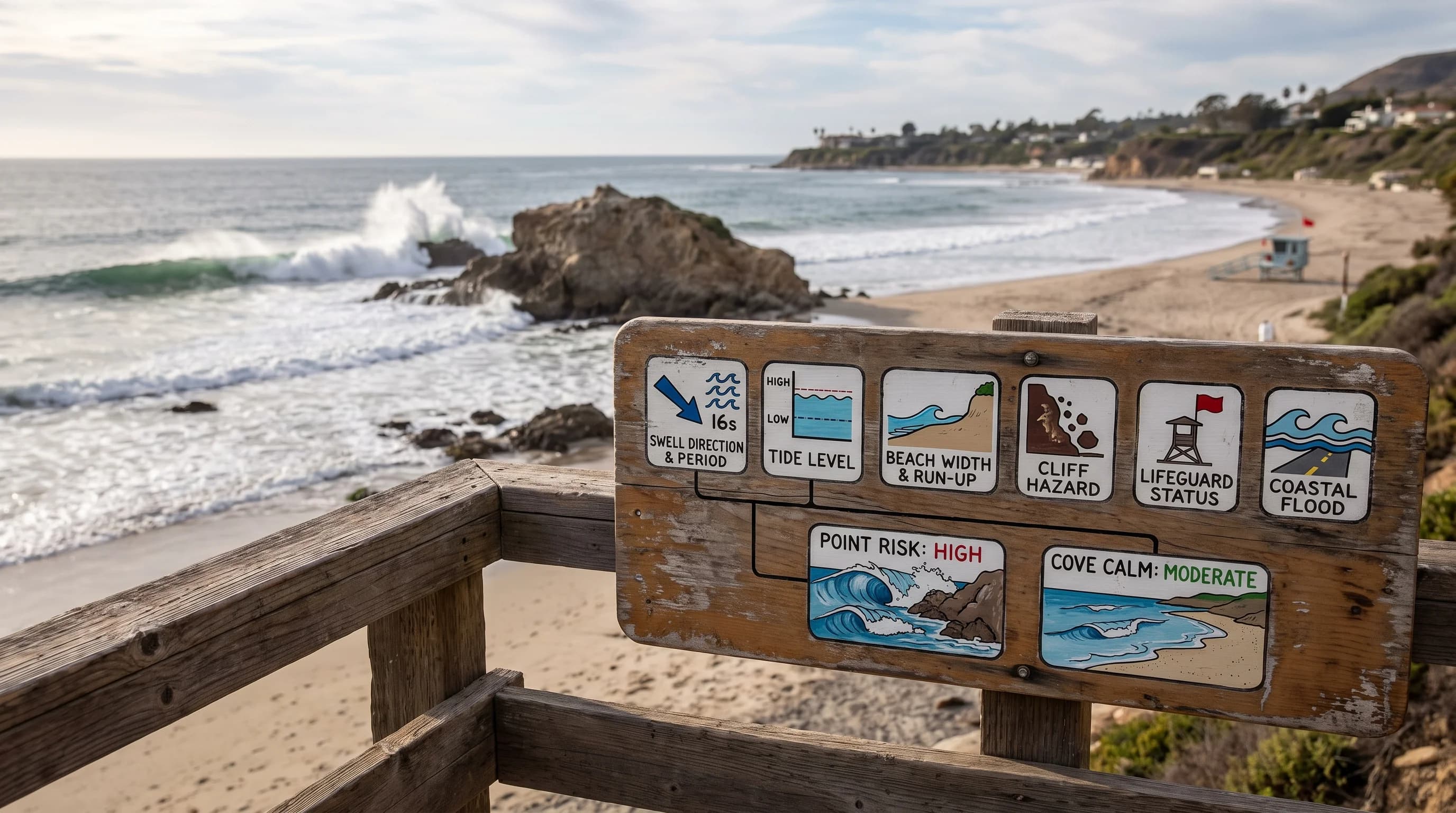
A visit-planning panel pairing swell direction, period, tide, run-up, beach width, cliff hazard, lifeguard status, and Coastal Flood products
Swell direction, period, and tide level combine differently at every Malibu beach, which is why a single offshore height number cannot describe local risk on its own.

How do High Surf and Coastal Flood alerts differ?

A High Surf Advisory or Warning describes the danger of breaking waves themselves, the risk to a person standing in or near the surf zone from wave impact, rip currents, and run-up. A Coastal Flood Advisory or Warning describes a different problem: water and wave wash reaching normally dry land such as beach parking lots, bike paths, and low sections of Pacific Coast Highway, driven by the combination of wave run-up and tide level rather than by local rainfall.

The two products often arrive together during a large swell, since the same energetic waves that make the surf zone hazardous also push water unusually far inland when they coincide with a high tide, but they are not interchangeable. A beach can carry a High Surf Warning with no coastal flooding at all if the swell arrives near low tide, and a lesser swell can still trigger coastal flooding if it lines up with an exceptionally high astronomical tide. For the timing of those especially high tides, see king tides in Southern California.

Pacific Coast Highway runs close to the shoreline through much of Malibu, and during the largest combined swell-and-tide events, wave wash and debris have closed travel lanes, required Caltrans cleanup, and in past storms damaged the roadway and adjacent infrastructure. This is a coastal flooding and erosion outcome, not a surf-zone swimming hazard, and it can affect drivers who never intend to go near the water. Broader coastal erosion patterns along the Southern California cliffs and beaches, including how repeated high surf and storm events reshape the shoreline over time, are covered in coastal erosion in Southern California.

What should a Malibu visitor check before going?

Before heading to the Malibu coast during or after a swell event, check five things together rather than any single number in isolation. First, the current NWS surf zone forecast and any active High Surf Advisory or Warning for the Malibu coastal zone from NWS Los Angeles/Oxnard. Second, the tide stage and timing from NOAA Tides and Currents, since the same swell behaves very differently at high versus low tide. Third, any active beach or lifeguard tower closures, which Los Angeles County Lifeguards post directly for specific stretches of coast rather than the whole region at once.

Fourth, water quality advisories, since large surf and storm runoff frequently trigger separate health warnings along the same beaches. Fifth, road status on Pacific Coast Highway itself during a major swell and tide event, since a route that is open in the morning can see lane closures by afternoon high tide.

The conservative rule for rocks, coves, and cliff-backed beaches in Malibu is simple: never turn your back on the ocean, and treat wet sand and exposed rock as part of the active surf zone rather than safe ground, because the wave that cuts off a dry route is rarely the first wave anyone sees. A beach that looks calm for several minutes can still be building toward a larger set, and a route that was dry on the walk out is not guaranteed to be dry on the walk back. For the general NWS beach hazard framework this guidance is built on, see the NWS beach hazards page.

High surf in Malibu is not a single, uniform event. It is the product of swell direction, period, tide, and a shoreline of points, coves, and cliffs that focuses ocean energy unevenly from one beach to the next. Understanding that mechanism, and checking the actual NWS surf, tide, and closure information for the specific beach in question, is what turns a genuinely hazardous coastline into a place that can still be visited safely. Before a trip to Malibu, Point Dume, or Zuma Beach, check current conditions on WeatherEscape's Los Angeles pages alongside the official NWS and NOAA sources above.

Frequently Asked Questions

What makes surf "high" in Malibu?

Surf counts as high in Malibu when breaking wave faces reach a level the National Weather Service Los Angeles/Oxnard office judges hazardous to people on or near the beach, tracked by coastal zone rather than a single subjective read on wave size. Wave period matters as much as height: a long-period swell of 15 to 20 seconds carries more energy and breaks with more force than a shorter-period swell reading the same height on an offshore buoy.

How do swell direction and Malibu's coastline interact?

Malibu's shoreline runs roughly east to west, facing south and southwest toward the open Pacific, which makes it unusually sensitive to south and southwest swell compared with beaches that face more directly into the region's prevailing northwest swell. Points and headlands such as Point Dume refract incoming swell, concentrating wave energy on some stretches of coast while sheltering coves tucked just around the same point.

Why are cliffs, rocks, and narrow beaches a special risk?

Cliffs, rocks, and narrow beaches shrink or eliminate the dry-sand buffer between a normal wave and a person standing on shore, so wave run-up reaches farther and more suddenly than it would on a wide, flat beach. A rocky route or narrow strip of sand that was dry on the way out can be cut off minutes later by a larger wave in the same set, and wet, algae-covered rocks near the waterline are more slippery than they appear.

Which storm tracks send Malibu its largest swells?

North Pacific winter storms tracking across the Gulf of Alaska from roughly October through March generate the most frequent large swells, arriving from the west to northwest with long periods. Southern Hemisphere storms, most active from roughly April through September, send south to southwest swell that matters disproportionately in Malibu because of its south-facing orientation, and tropical cyclones off Mexico can occasionally add south to southeast swell in summer and early fall.

How do High Surf and Coastal Flood alerts differ?

A High Surf Advisory or Warning describes the danger of breaking waves in the surf zone, including rip currents and run-up risk to people in or near the water. A Coastal Flood Advisory or Warning describes wave run-up and tide-driven water reaching normally dry land such as beach parking lots and sections of Pacific Coast Highway, a mechanism tied to tide level rather than local rainfall, and the two products often arrive together during a large swell but are not interchangeable.

How can high surf and king tides combine to flood or erode Malibu's coastline?

When an energetic swell coincides with an especially high astronomical tide, sometimes called a king tide, wave run-up reaches significantly farther inland than the same swell would at a lower tide, increasing both flooding of low-lying areas and erosion of beaches and bluffs. Timing matters more than raw swell size in these events, since a moderate swell at a king tide can cause more coastal impact than a larger swell arriving near low tide.

Can high surf damage the Pacific Coast Highway in Malibu?

Yes. During the largest combined swell-and-tide events, wave wash and debris have closed travel lanes on Pacific Coast Highway in Malibu and required Caltrans cleanup, and past storms have damaged the roadway and adjacent infrastructure in the most severe cases. This is a coastal flooding and erosion outcome tied to wave run-up and tide level, and it can affect drivers who have no intention of going near the water.

What should a Malibu visitor check before going during high surf?

Check the current NWS surf zone forecast and any active High Surf Advisory or Warning from NWS Los Angeles/Oxnard, the tide stage and timing from NOAA Tides and Currents, active Los Angeles County Lifeguards beach closures, water quality advisories, and Pacific Coast Highway road status together, since a route that is open in the morning can see lane closures by afternoon high tide.

Is a Malibu point break more dangerous than a Malibu cove during the same swell?

It depends on how each spot is oriented to the incoming swell direction. A point that faces the swell directly can see wave energy refract and stack into larger, more organized breakers, while a cove sheltered behind that same point, or protected by an offshore reef or kelp bed, can stay comparatively calm during the identical storm, which is why lifeguards and NWS forecasters describe conditions by specific beach rather than a single number for the whole Malibu coast.

Related Destinations

Live Los Angeles Conditions

Compare temperature, wind, clouds, and comfort across the map.

See which microclimates are clear, cool, windy, smoky, or warming up right now.

Open the Weather Map
Destinations☀️Smog Forecast🌫️Smog Heat Map🔒Privacy Policy📄Terms of Service