beach weathersafetysevere weathertips

Rip Currents Aren't Rip Tides: Spot the Channel

By WeatherLA|Published |Last updated |10 min read
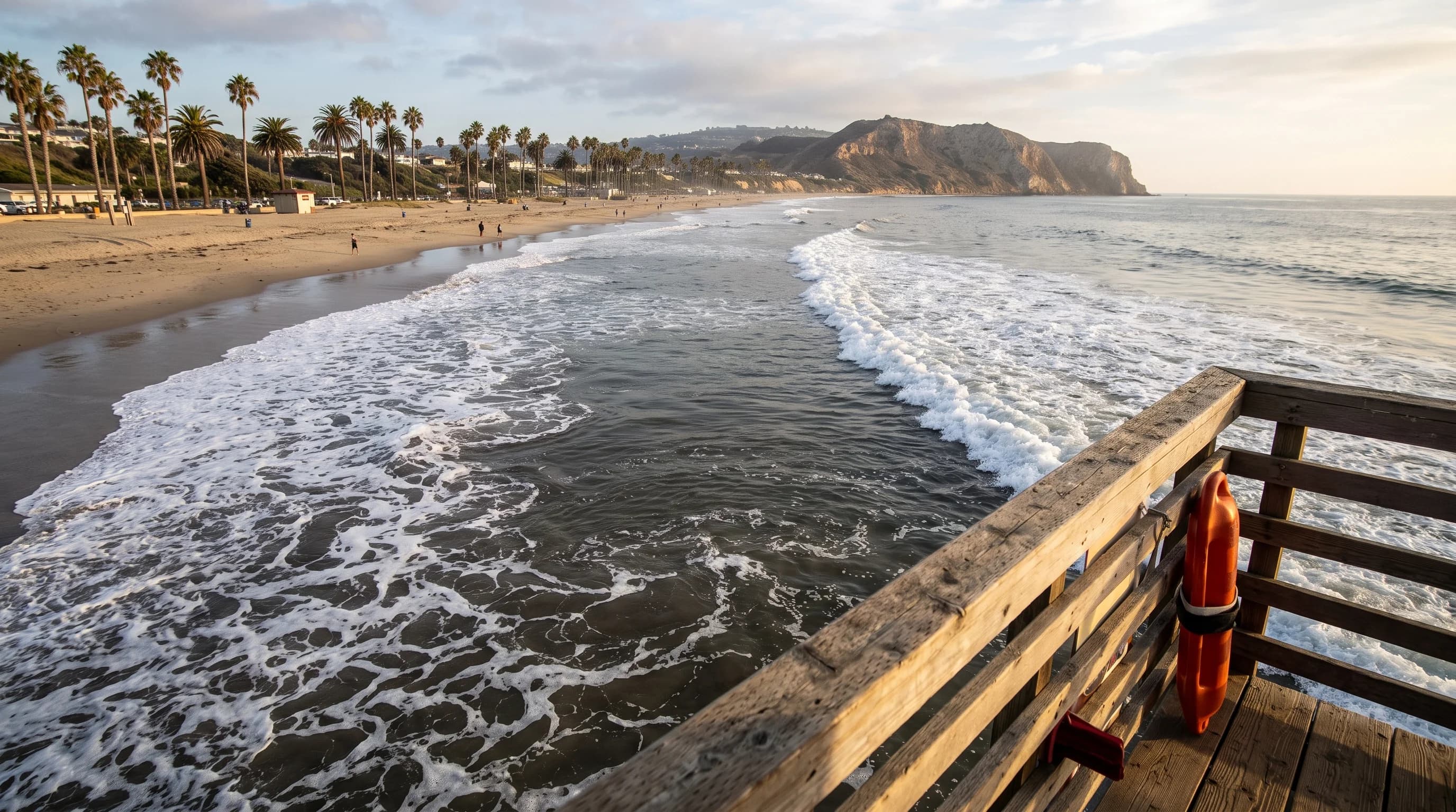
An elevated lifeguard-style view of a Southern California beach showing a darker rip current channel and foam streaking seaward between two areas of breaking waves

Key Takeaways

  • A rip current is a narrow, fast-moving channel of water flowing away from shore through a gap in a sandbar or next to a structure like a pier or jetty, not an undertow that pulls swimmers underwater.
  • The clearest visual signs are a calmer gap between areas of breaking waves, choppy or streaky water, a murky sediment plume, and foam or debris drifting steadily seaward.
  • Some rip currents show no visible warning sign at all, especially in flat surf or overcast light, which is why checking the official surf forecast matters as much as scanning the water.
  • Risk depends on swell height, swell period, tide stage, and sandbar shape together, not on the tide alone, so NWS beach hazard statements are the most reliable single check.
  • "Rip tide" is a misleading name. The current is driven by breaking waves and beach shape, not by the moon-driven tidal cycle tracked at NOAA tide stations.
  • If caught, float, do not fight the current straight back to the beach, swim parallel to shore when you can, and signal for a lifeguard rather than letting a bystander attempt an unassisted rescue.

A rip current is a narrow, fast-moving channel of water flowing away from shore, formed where breaking waves pile water against the beach and that water finds a concentrated path back out through the surf zone, often through a gap in a sandbar. It is not an undertow and it does not pull swimmers underwater. It pulls them away from the beach, usually through a visible or semi-visible channel of choppier, discolored, or foam-streaked water between breaking waves. Spotting that channel before you enter the water, and knowing how to swim out of one if it catches you, is the single most useful piece of beach safety knowledge for anyone swimming along the Santa Monica or Malibu coastline.

What is a rip current?

A rip current is a localized, seaward-flowing current that forms within the surf zone, the band of water between the breaking waves and the shoreline. Waves push water toward the beach continuously, and that water has to return to deeper water somehow. Where the seafloor and sandbar shape create a natural low point or channel, the returning water concentrates into a narrow stream instead of spreading evenly back out, and that stream can move much faster than a person can swim against it. According to the National Weather Service rip current safety guidance, rip currents are the leading surf hazard for beachgoers and a major cause of lifeguard rescues nationwide.

The term "undertow" is a persistent myth worth retiring. There is no current at SoCal beaches that pulls swimmers down and holds them underwater. A rip current moves along the surface, roughly perpendicular to the shoreline or at a slight angle, carrying a swimmer outward past the breaking waves rather than downward. That distinction matters because it changes the correct response: fighting straight back toward the beach against a rip current wastes energy against a current stronger than most swimmers, while recognizing that the current is a horizontal conveyor, not a sinking trap, is the first step toward the correct escape.

How do waves and beach shape create a rip current?

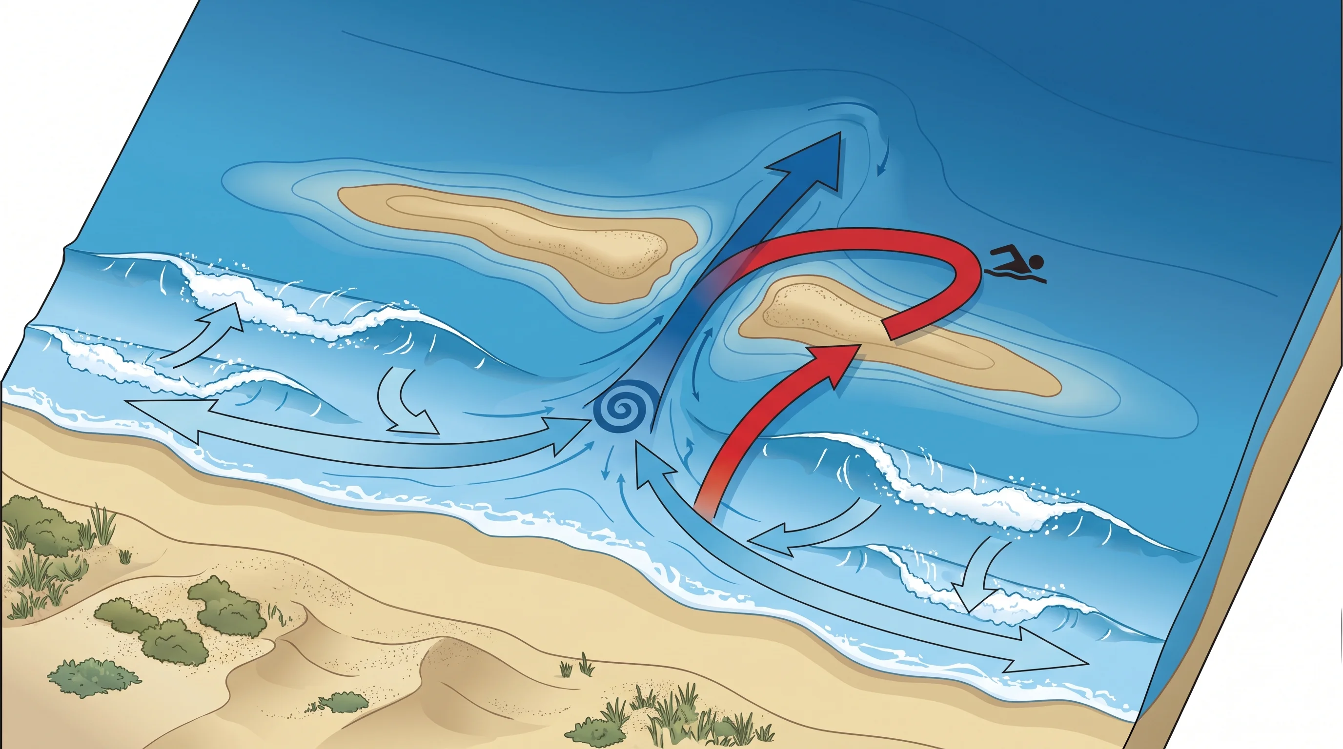
Rip currents form from a simple imbalance: water arrives at the beach faster than it can drain evenly back out. As waves break, they push water up the slope of the beach in a process called wave setup, temporarily raising the water level near shore. That excess water has to flow back toward open water, and it takes the path of least resistance, typically a gap or deeper channel in a sandbar, a break between rock groins or piers, or a low point next to a jetty. Water funnels into that channel from both directions along the beach, called feeder currents, then shoots seaward through the gap in a concentrated neck before spreading and slowing past the outermost breaking waves in what is often called the current's head.

Sandbar-cut rips are the most common type on open, sandy Southern California beaches, and their location can shift with the sand itself. A sandbar that creates a rip channel after one storm can fill in or move within days or weeks, which is why a spot that felt safe on a previous visit is not a guarantee for the next one. Structural rips form next to fixed features like piers, jetties, and rock groins, which interrupt the natural longshore flow of water and concentrate it into a permanent or semi-permanent channel alongside the structure. These tend to be more predictable in location but are not necessarily any weaker, and swimming near a pier or jetty carries the added risk of being swept into the structure itself.

How can you spot a possible rip current?

Before entering the water, scan the surf zone for a break in the wave pattern rather than looking for a single obvious feature. Waves break more consistently over shallow sandbars and break less, or not at all, over the deeper water of a rip channel, so a calmer-looking gap flanked by breaking whitewater on both sides is one of the most reliable visual cues. Water in the channel itself often looks choppy, streaky, or textured differently from the smoother water around it, because the outgoing current is disturbing the surface against incoming swell.

Discoloration is another strong signal: a rip current stirs up sand and sediment from the bottom, so a murky, brownish, or sandy-colored plume extending out past the break often traces the exact path of the current. Foam, seaweed, or floating debris drifting steadily out to sea, rather than rolling in with the waves, is doing exactly what a swimmer caught in the same current would do.

Rip Current Warning Signs: What to Look for Before You Swim
Visual signWhat it looks likeWhy it happens
Gap in breaking wavesA calmer channel where waves break less or not at all, flanked by whitewater on both sidesDeeper water in the rip channel does not trip waves into breaking the way the shallower sandbar does
Choppy or streaky surfaceTextured, disturbed water that looks different from the smoother swell around itOutgoing current colliding with incoming swell roughens the surface
Discolored or murky waterA brownish, sandy, or turbid plume extending seaward past the surf lineThe current is stirring up and carrying bottom sediment
Foam, seaweed, or debris lineFoam or floating material moving steadily out to sea instead of washing toward the beachFloating material tracks the same seaward flow that would carry a swimmer
No visible signSurf can look deceptively even and calmSome rip currents, especially on overcast days or in flat, low-energy surf, show few or no visual cues

That last row matters as much as the others. The NOAA Ocean Service is explicit that rip currents are not always visible from the beach, particularly in flat or overcast light, which is why visual identification should be treated as one layer of protection rather than a guarantee. Checking official surf and beach hazard guidance before entering the water, and swimming near an open, staffed lifeguard tower, adds a second and third layer that a glance at the water alone cannot provide.

Overhead diagram of a Southern California surf zone showing waves piling water near the shoreline, feeder currents converging on a gap in an offshore sandbar, a concentrated seaward-flowing rip channel through the gap, and an arrow showing the correct escape path swimming parallel to shore before returning to the beach
A rip current forms where wave-driven water finds a concentrated path back through a break in the sandbar. The safest way out is parallel to the beach, not straight against the current.

When is rip current risk highest?

Rip current risk is not governed by a single rule like the tide alone. It is a combination of swell size, swell period, tide stage, and the shape of the beach and sandbars on a given day, which is exactly why the NWS Los Angeles/Oxnard office and NWS San Diego office issue beach hazard statements and surf zone forecasts rather than a fixed formula. Larger breaking waves push more water toward shore, increasing the volume that has to drain back out and strengthening any current that forms.

A longer swell period, the time between wave crests, tends to build more powerful surf than short-period wind chop of the same height, so a solid west or south swell with a long period is a signal to check conditions closely even if the sky is clear and the wind is calm. Tide stage matters too: many Southern California beaches see rip activity increase around mid to low tide, when more of the sandbar structure is exposed and channels become more defined, though this pattern varies by beach and is not a substitute for checking the forecast.

The most reliable single resource is the surf zone forecast and any active beach hazard statement from your local NWS office, which factors in swell, period, tide, and wind together rather than any one variable in isolation. Lifeguard-posted flags and signage at staffed beaches, including in Santa Monica and Malibu, reflect on-the-ground conditions that can change within a single afternoon as swell and tide shift, so checking both the posted flags at the tower and the day's forecast before entering the water is the right combination. Because swimming conditions can look deceptively calm even when a NWS beach hazard statement is active, treat the official forecast as the primary source and your own visual read of the water as a secondary check, not the other way around.

Why is a rip not a rip tide?

"Rip tide" is a common misnomer that the NWS and NOAA both discourage, and the distinction is not just pedantic. A true tide is the slow, twice-daily rise and fall of sea level driven by the gravitational pull of the moon and sun, tracked at official stations through NOAA Tides and Currents. A rip current has essentially nothing to do with that cycle. It is a wave-driven, surf-zone phenomenon that can appear, strengthen, weaken, or shift location within minutes to hours as swell and sandbar conditions change, independent of whether the tide is rising or falling at that moment.

Calling it a rip tide invites the false impression that the hazard tracks a predictable, slow-moving schedule like the tide does, when in fact swell and beach shape, not the tide alone, are doing most of the work. Using the correct term, rip current, keeps the mental model accurate: this is a current produced by breaking waves finding a way back to sea, not a tide doing anything unusual.

What should a caught swimmer do?

The standard, widely published guidance from the NWS and the United States Lifesaving Association is to stay calm, float, and avoid swimming directly against the current. A rip current will not pull a swimmer under, and most rip currents lose their strength once they pass beyond the breaking waves, so panicked, energy-draining strokes straight back toward the beach are the most dangerous response, not the current itself.

Float or tread water while the current carries you outward, and if you are able, swim parallel to the shoreline for a short distance to exit the width of the current before turning back in on your own power, catching the energy of breaking waves to assist your return. If you cannot escape by swimming, float and signal for help by waving your arm and calling out, drawing the attention of a lifeguard or nearby beachgoer rather than continuing to fight the water.

If you see someone else caught in a rip current, the correct move is to alert a lifeguard immediately or call 911 rather than swimming out yourself. Attempting an unassisted rescue without a flotation device or professional training is one of the most common ways a single rip current incident turns into a double rescue or drowning, since the rescuer enters the same current with none of the equipment a lifeguard carries. If a flotation device, such as a cooler, boogie board, or anything else that floats, is available, throw it to the swimmer instead of entering the water.

Staffed beaches with an open lifeguard tower, including popular stretches of Santa Monica and Malibu, give both swimmers and bystanders the fastest path to a trained rescue, which is a major reason lifeguards consistently recommend swimming only in front of an open tower.
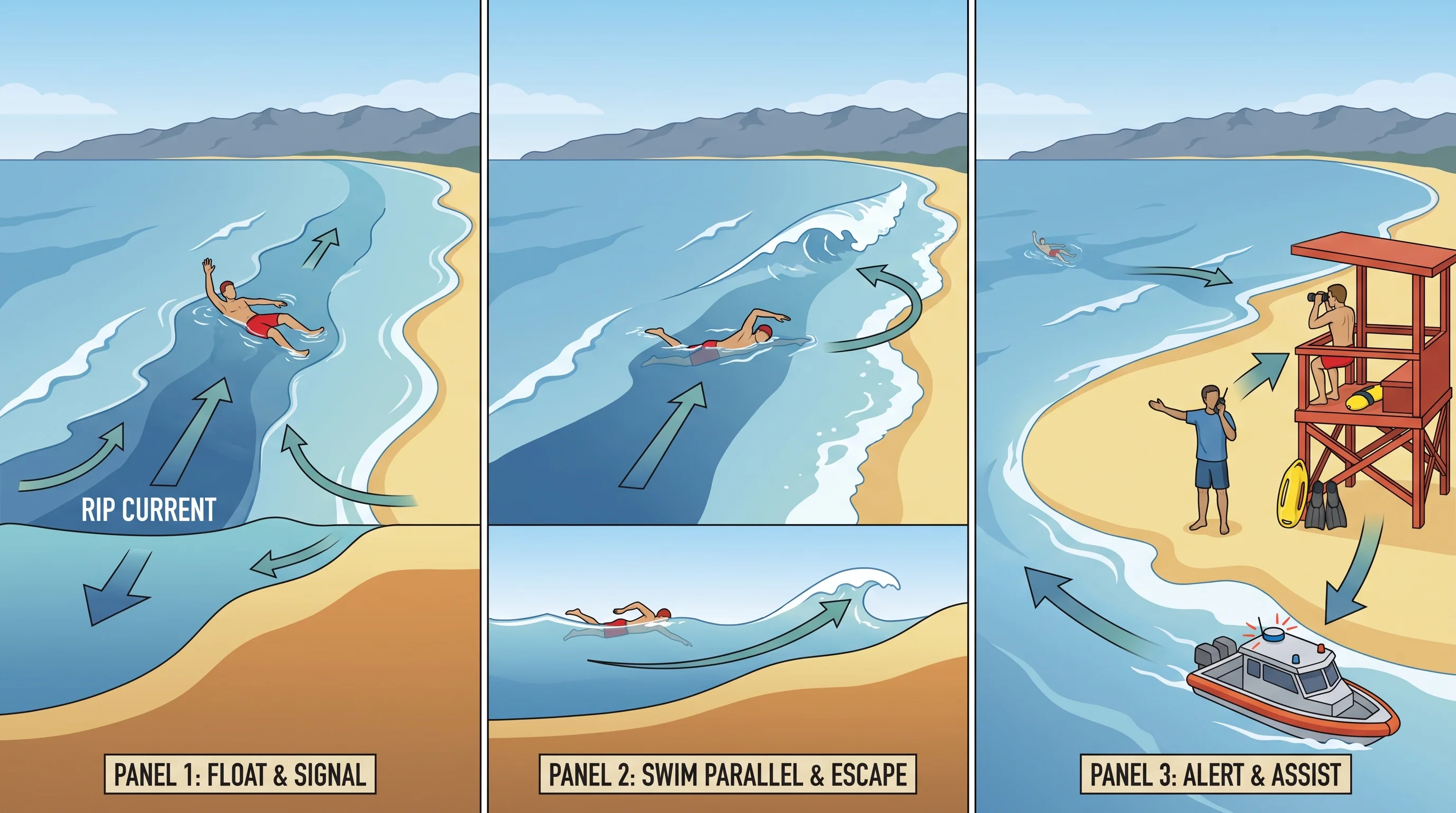
Rescue action graphic showing a swimmer floating and waving one arm to signal for help while caught in a rip current, a second panel showing the swimmer swimming parallel to shore before catching breaking waves back to the beach, and a third panel showing a bystander alerting a lifeguard rather than entering the water unassisted
Float, signal, and swim parallel to shore when you can. If you are on the beach watching someone else struggle, alert a lifeguard or call 911 instead of swimming out yourself.

Rip currents are a predictable hazard once you know what to look for, but the ocean does not owe anyone a visible warning sign every time. Before swimming anywhere along the Southern California coast, check the day's surf height and period, tide stage, and any active beach hazard statement from NWS Los Angeles/Oxnard or NWS San Diego, look for a staffed lifeguard tower and swim in front of it, and confirm the beach is not under a closure or advisory.

That combination, an official forecast checked before you go plus a careful look at the water once you arrive, is what actually keeps a day at Santa Monica, Malibu, or any other SoCal beach safe. For related coastal hazards, see can a tsunami hit Southern California, and for how summer heat shapes beach crowds inland, see what is the heat index.

Frequently Asked Questions

What is a rip current?

A rip current is a narrow, fast-moving channel of water that flows away from the beach through the surf zone, typically through a gap in an offshore sandbar or alongside a structure like a pier or jetty. It forms because waves push water toward shore faster than it can drain back out evenly, so the return flow concentrates into one channel. It is not an undertow and does not pull swimmers underwater; it carries them along the surface, away from the beach.

How do waves and beach shape create a rip current?

Breaking waves raise the water level near shore in a process called wave setup, and that extra water has to return to open water somehow. It finds the path of least resistance, usually a deeper channel cut through a sandbar or a gap next to a fixed structure, and funnels through that gap from both directions along the beach before shooting seaward in a concentrated current. Sandbar-cut rips can shift location as sand moves with storms and swell, while rips next to piers and jetties tend to stay in a more fixed spot.

How can you spot a possible rip current?

Look for a calmer-looking gap in the wave-breaking pattern, flanked by whitewater on both sides, since deeper water in a rip channel does not trip waves into breaking the way a shallow sandbar does. Other signs include choppy or streaky water, a murky or discolored sediment plume extending seaward, and foam, seaweed, or debris drifting steadily out to sea instead of washing toward the beach. Some rip currents show none of these signs, particularly in flat surf or overcast light, so a clear-looking ocean is not a guarantee of safety.

When is rip current risk highest?

Risk rises with larger breaking waves, a longer swell period, and sandbar or beach shapes that concentrate the return flow into a narrow channel, and many Southern California beaches see rip activity increase around mid to low tide as more sandbar structure becomes exposed. No single rule like the tide alone predicts risk reliably, which is why NWS Los Angeles/Oxnard and NWS San Diego issue combined beach hazard statements and surf zone forecasts that factor in swell, period, tide, and wind together.

Why is a rip not a rip tide?

A true tide is the slow, twice-daily rise and fall of sea level driven by the gravitational pull of the moon and sun, tracked at official NOAA tide stations on a predictable schedule. A rip current has essentially nothing to do with that cycle; it is a wave-driven surf-zone current that can appear or change within minutes to hours as swell and sandbar conditions shift, regardless of whether the tide is rising or falling. The NWS and NOAA both discourage the term "rip tide" because it implies a slow, tide-like predictability that the hazard does not actually have.

What should a caught swimmer do?

Stay calm, float, and avoid swimming directly against the current back toward the beach, since most rip currents weaken once they pass beyond the breaking waves and panicked swimming against them wastes energy fast. Swim parallel to the shoreline when you are able to exit the width of the current, then let breaking waves carry you back in, and if you cannot escape by swimming, float and signal for help by waving an arm and calling out to a lifeguard or nearby beachgoer.

What should you do if you see someone else caught in a rip current?

Alert a lifeguard immediately or call 911 rather than swimming out yourself. Attempting an unassisted rescue without a flotation device or training is one of the most common ways a single rip current incident becomes a double rescue, since the would-be rescuer enters the same current with no equipment. If something that floats is nearby, such as a cooler or boogie board, throw it to the swimmer instead of entering the water.

Are rip currents more common at certain Southern California beaches?

Rip currents can form at essentially any open sandy beach in Southern California, and their exact location shifts as sandbars move with storms and swell rather than staying fixed at one spot on a beach. Beaches with piers, jetties, or rock groins, including stretches near Santa Monica and Malibu, tend to have more predictable rip locations right alongside the structure, though these are not necessarily any weaker than sandbar-cut rips elsewhere on the same beach.

Related Destinations

Live Los Angeles Conditions

Compare temperature, wind, clouds, and comfort across the map.

See which microclimates are clear, cool, windy, smoky, or warming up right now.

Open the Weather Map
Destinations☀️Smog Forecast🌫️Smog Heat Map🔒Privacy Policy📄Terms of Service