
A waterspout is a rotating column of air connecting a cloud to the water surface below, and Southern California sees them off the coast almost every year. Most are fair-weather waterspouts, weaker spins that grow up from the surface under a building cumulus cloud with no thunderstorm. A smaller share are tornadic waterspouts, which form inside a severe thunderstorm like a land tornado and are dangerous if they move ashore. Both types appear off beaches from Malibu to Santa Monica, and the type decides how seriously to take one.
What Is a Waterspout?
A waterspout is a rotating, funnel-shaped column of air reaching from the base of a cloud down to a water surface. Condensation and spray lifted off the water make it visible. Choppy water, a gust front throwing spray or a squall's straight-line wind can look dramatic from shore without being a waterspout. A true waterspout has a visible or clear connection between rotation in the cloud and a funnel or spray swirl at the surface.
Meteorologists divide waterspouts into fair-weather and tornadic types. The difference decides how the waterspout forms, how dangerous it is and which warning, if any, the National Weather Service issues. The NWS Los Angeles/Oxnard and San Diego forecast offices cover the Southern California coast and watch for both types in routine marine forecasting.
How Do Fair-Weather and Tornadic Waterspouts Differ?
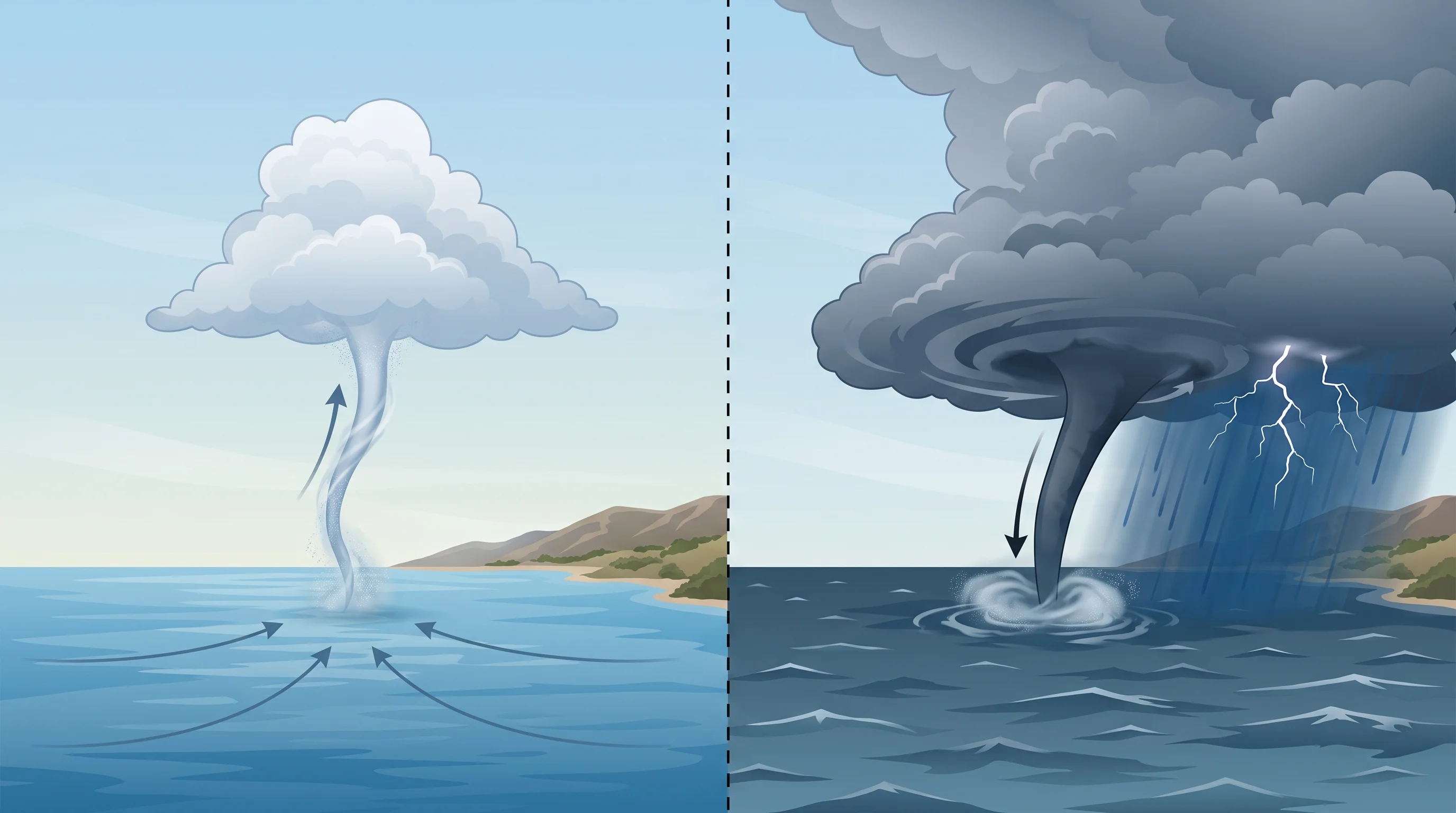
Fair-weather waterspouts grow from the water surface upward, while tornadic waterspouts descend from a rotating thunderstorm like a land tornado. A fair-weather waterspout usually forms under a line of building cumulus clouds along a surface boundary, where light winds meet and create a small area of spin near the water. As the cloud grows, it stretches that spin upward. The result is usually narrow, short-lived and fairly weak, often fading within 10 to 20 minutes.
A tornadic waterspout forms inside a severe or organized thunderstorm, with rotation developing high in the storm and extending down to the water. A tornadic waterspout can be stronger and longer-lasting, and it usually comes with lightning, gusty wind and heavy rain.
For people on or near the water, the two types differ in risk and warning. Fair-weather waterspouts, by far the more common type off Southern California, are usually weaker and often prompt a Special Marine Warning, not a Tornado Warning. A tornadic waterspout gets the same urgency as a land tornado, because it is a tornado over water.
| Characteristic | Fair-weather waterspout | Tornadic waterspout |
|---|---|---|
| How it forms | Builds surface-up under a growing cumulus cloud | Descends from rotation inside a severe thunderstorm |
| Parent weather | Light wind, developing convection, often little to no lightning | Organized thunderstorm, often with lightning and heavy rain |
| Typical lifespan | Roughly 10 to 20 minutes | Can last longer and track farther |
| Typical intensity | Generally weaker | Can be as strong as a land tornado |
| SoCal frequency | The far more common type off the coast | Uncommon, tied to stronger storm systems |
| NWS product if observed | Often a Special Marine Warning | Tornado Warning if it threatens land |
When Do Waterspouts Form Off Southern California?
Waterspouts form off Southern California when cold, unstable air moves over warmer ocean water and meets a surface boundary where winds converge, giving rotation a place to start. This setup is most common in the cool season, from late fall through spring, when Pacific storms bring cold air over water that has not cooled as fast. The temperature contrast between cold air above and milder water below creates the instability that builds the small, fast-growing cumulus clouds behind fair-weather waterspouts.
A convergence zone, where light winds from different directions meet along the coast or offshore, often turns ordinary building cumulus into a rotating column. Convergence zones form along sea breeze boundaries or where cool offshore air meets the marine layer. NWS Los Angeles/Oxnard and NWS San Diego note higher waterspout potential in their marine forecast discussions when these ingredients line up, usually after a cold front leaves cold air over still-mild coastal water.
Tornadic waterspouts need stronger, more organized storms and are rarer off Southern California. They come with the same cool-season storms that can produce land tornadoes in the region. For how wind shear and low-topped storms interact with the coast, and the confirmed regional tornado record, see can tornadoes hit Southern California.
Can a Waterspout Move Onshore?
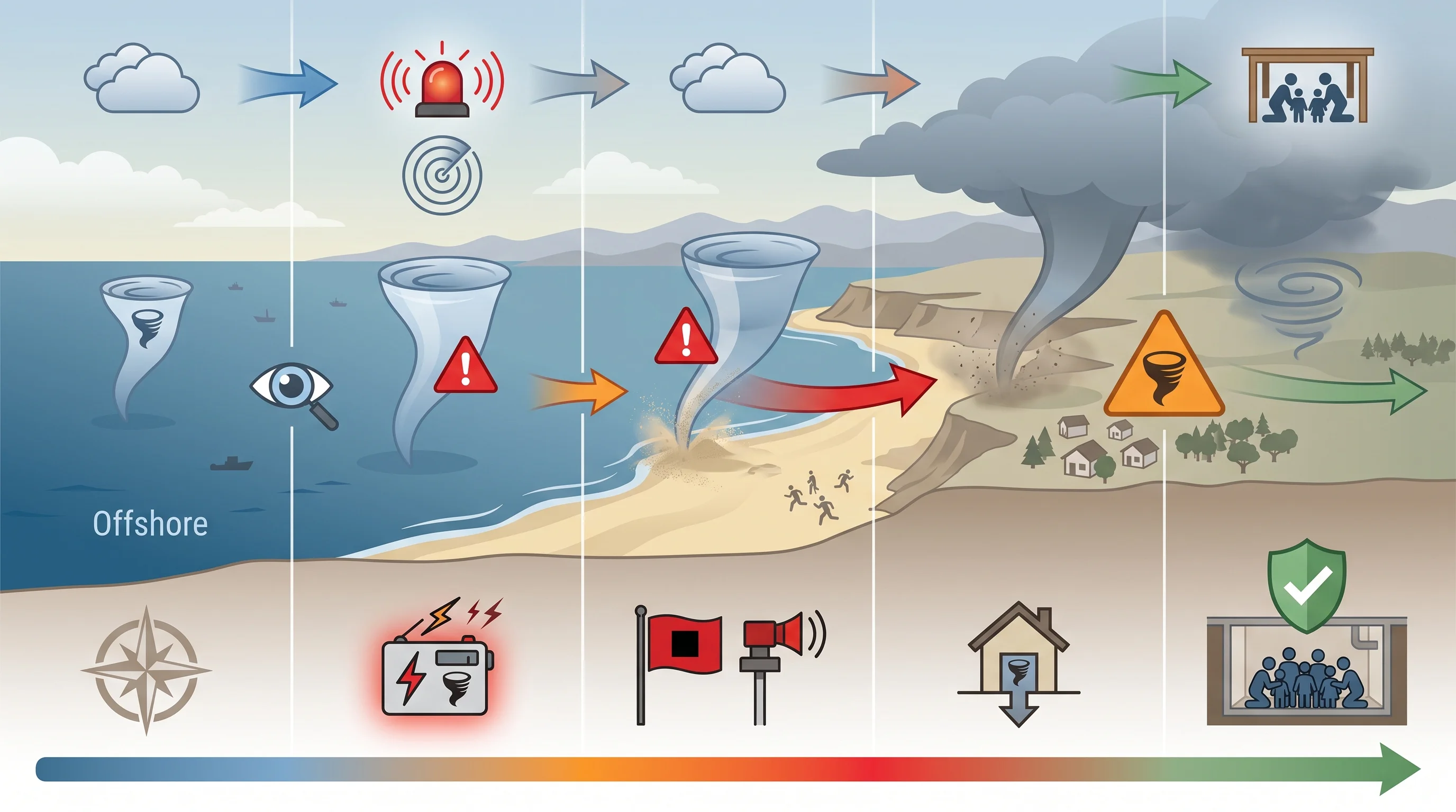
A waterspout can move onshore, and when it crosses the beach while still connected to its cloud, it becomes a tornado. Only the name changes: the same rotating column is a waterspout over water and a tornado over land.
After landfall, it may weaken, hold steady or strengthen, depending on the storm and how much friction and the air over land disrupt it. Some waterspouts fall apart within seconds of reaching the beach. Others have come ashore near Southern California communities strong enough to damage trees, power lines and buildings.
An approaching waterspout can hold or gain strength right up to landfall, so NWS forecasters treat one heading for the coast as a real threat. NWS Los Angeles/Oxnard or NWS San Diego can issue a Tornado Warning for the coastal area in its path. If you are watching a waterspout from a beach or bluff, assume it can keep moving and spinning after it reaches land; the shoreline is not a safety line.
How Is a Waterspout Different From a Marine Dust Devil?
A waterspout always connects to a cloud overhead; a dust devil forms from surface heating on a hot, calm day with no cloud connection. Dust devils are common in Southern California's inland valleys and deserts, where strong sun heats the ground unevenly and creates small, brief swirls that lift dust and debris. They occasionally form or drift near water on very hot, still days, but they are shallow surface features driven by heat, not a cloud's rotation.
Rotation depth is the other difference. A waterspout's spin reaches from the cloud base to the water, through a deep layer of the atmosphere. A dust devil's spin stays in a shallow layer near the ground and never reaches a cloud; the hot, calm days that produce dust devils often have no cloud overhead at all. An unbroken funnel or condensation column from a cloud down to the water is a waterspout.
A spinning column of spray or dust under clear sky or scattered clouds is not a waterspout. For a side-by-side comparison of tornadoes, waterspouts, microbursts and dust devils, see can tornadoes hit Southern California.
What Should Boaters and Beachgoers Do?
Boaters and beachgoers should give any waterspout a wide berth and never approach or drive through one, according to NWS marine safety guidance. Boaters should turn away at a right angle to its path instead of trying to outrun it, because waterspouts change direction with little warning, and head for the nearest harbor or safe anchorage. On beaches near Santa Monica and Malibu, where waterspouts have been seen, move away from the water toward solid shelter if one is reported nearby.
Before going out on the water in unsettled weather, check the marine forecast and any Special Marine Warning or Tornado Warning from NWS Los Angeles/Oxnard or NWS San Diego, along with radar and lightning. The NWS beach hazards guidance and NOAA Tides and Currents help assess other coastal conditions, because days with waterspout potential often bring other marine hazards.
What Happens if You Go Through a Waterspout?
Going through even a weak fair-weather waterspout means sudden, strong spinning wind and heavy spray, with a real risk of capsizing a small boat, losing control or being hit by flying debris. A tornadic waterspout carries the same hazards as a land tornado: it can flip small boats, tear sails and damage piers, marinas and beachfront buildings. No waterspout encounter is safe to ride out, so NWS guidance is to steer away well before one gets close.
Are Waterspouts Harmless?
Waterspouts are not harmless, though most Southern California waterspouts are the weaker fair-weather type and fade over open water without threatening anyone. Risk depends on type and distance.
A fair-weather waterspout far offshore and moving away poses little risk to someone on the beach. Any waterspout near boats, a marina or moving toward shore can capsize vessels, damage property and injure people. Distance and direction can change quickly.
Waterspouts are a regular part of Southern California's cool-season coastal weather, and the right response depends on whether you face a fair-weather spin or a tornadic waterspout heading for land. Before going on the water or to the beach in unsettled weather, check the marine forecast, radar and any warnings from NWS Los Angeles/Oxnard or NWS San Diego. Give any reported waterspout a wide berth.