phenomenawindair qualitysafetytrip planning

SoCal Dust Storms: Formation and Driving Safety

By WeatherLA|Published |Last updated |10 min read
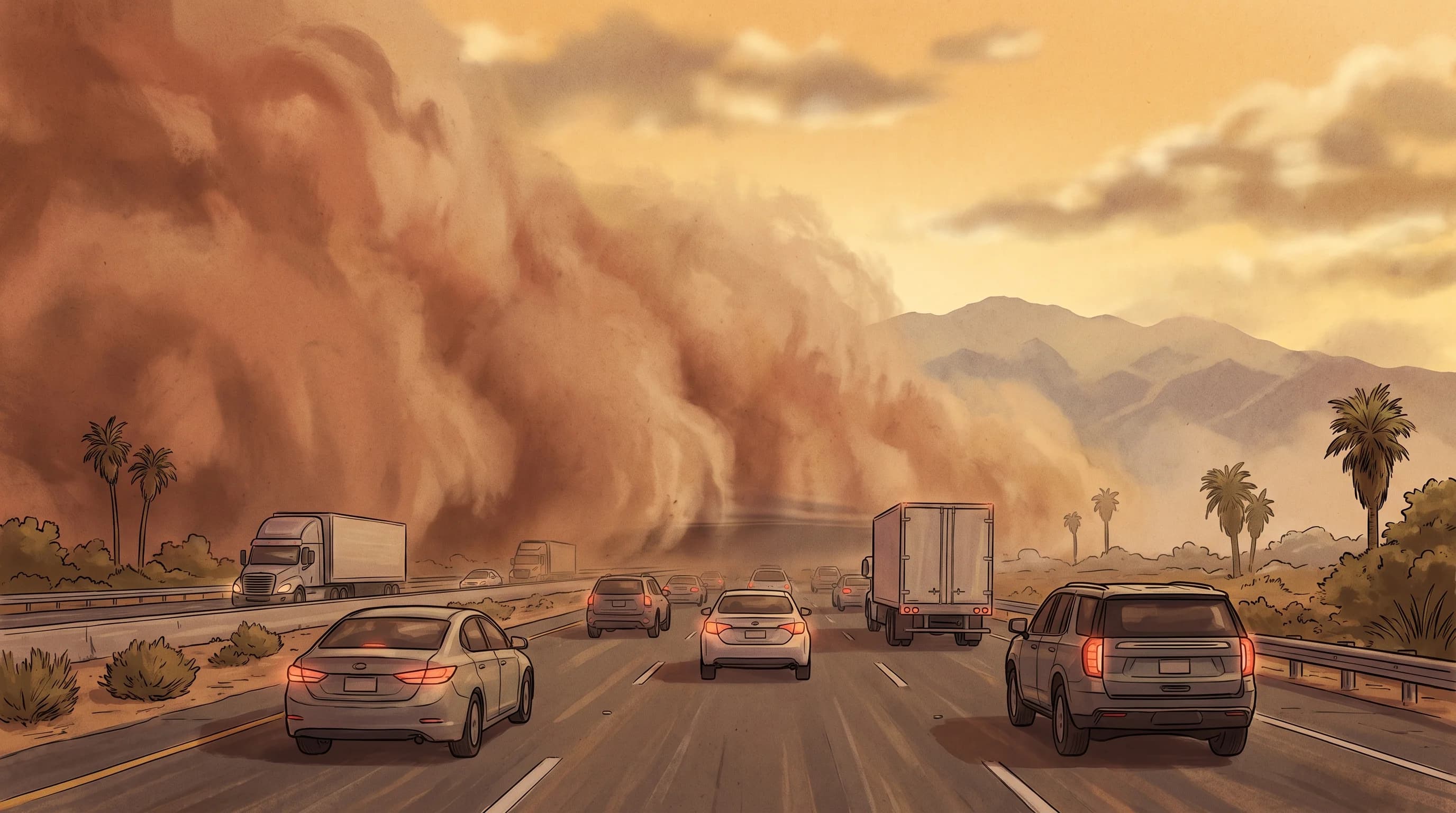
A wall of desert dust crossing a Southern California highway at a safe distance, with vehicles slowing before the visibility boundary and mountains fading behind it

Key Takeaways

  • A dust storm is any wind event that lifts loose soil high enough to sharply cut visibility; a haboob is a specific type driven by a collapsing thunderstorm outflow, and Southern California sees both.
  • Dust storms need three ingredients together: dry, loose, sparsely vegetated soil, a wind strong enough to break the surface crust, and open fetch for the wind to gather material, which is why dry lakebeds and disturbed desert soil are frequent source areas.
  • The Coachella Valley near Palm Springs and the Mojave Desert corridor along I-15 and I-10 see the region's most persistent blowing-dust exposure, driven by spring gradient winds and summer thunderstorm outflows.
  • Highway visibility can drop from clear to near zero in under a minute as a moving dust front crosses the road, which is why Caltrans and NWS guidance both say to avoid stopping in a travel lane if you get caught in one.
  • Blowing dust is measured as PM10, coarse particulate matter, and a fixed air-quality monitor miles away can completely miss a narrow, fast-moving plume even while it is choking a nearby roadway.
  • Before any desert drive or hike, check the current NWS Dust Storm Warning status, Caltrans QuickMap camera images, and wind forecast for your full route, not just your destination.

Southern California dust storms form when strong wind lifts loose, dry desert soil off exposed ground, cutting highway visibility from clear to near zero in a matter of minutes. They are most common across the Coachella Valley near Palm Springs, the Mojave Desert corridor along Interstate 15, and the Imperial Valley, where dry lake beds and open desert floor give the wind both loose material and unobstructed distance to work with. A dust storm and a haboob are related but not identical: every haboob is a dust storm, but not every dust storm is a haboob, and the difference matters for how fast the hazard arrives.

What is a dust storm, and is it a haboob?

A dust storm is any weather event in which wind lifts enough loose soil into the air to significantly reduce visibility, sometimes down to a few car lengths or less. The National Weather Service issues a Dust Storm Warning when visibility is expected to fall to a quarter mile or less because of blowing dust, a threshold chosen because that is roughly the point where highway driving becomes genuinely dangerous. A haboob is a specific, more dramatic type of dust storm: a dense, often mile-high wall of dust pushed outward by the collapsing downdraft of a thunderstorm. The name comes from the Arabic word for blowing wind and was adopted by American meteorologists because it precisely describes the wall-cloud appearance of the phenomenon.

Southern California sees both kinds. A slower, steadier gradient-wind dust event can build over hours as a strong pressure difference pushes air across the open desert. A haboob, by contrast, can form in minutes when a collapsing summer thunderstorm cell sends a gust front racing outward ahead of the storm, dragging a visible wall of dust across the Coachella or Mojave desert floor. Both reduce visibility and both matter for driving safety, but a haboob typically arrives with far less warning, which is one reason the NWS Los Angeles/Oxnard office and the NWS San Diego office treat thunderstorm-driven dust as a distinct forecast concern from routine windy-day dust.

Two Ways Southern California Gets Blowing Dust
FeatureGradient-wind dust eventHaboob (outflow-driven)
TriggerSustained pressure gradient across the desertCollapsing thunderstorm downdraft
Typical seasonSpring, especially windy afternoonsSummer monsoon thunderstorm season
Onset speedBuilds over hours as wind strengthensCan form and arrive within minutes
Visible shapeWidespread haze or drifting dust sheetsA defined, often towering wall of dust
DurationCan persist for many hoursOften passes through in 15 to 30 minutes

How do desert dust storms form?

Desert dust storms need three ingredients together: loose, dry soil with little vegetation holding it down, wind strong enough to break the surface crust of that soil, and enough open fetch, meaning unobstructed distance, for the wind to keep gathering material as it travels. Vegetation and a stable soil crust are the main things standing between a windy day and a dust event; when either is missing, far less wind is needed to start lofting particles. This is why dry lake beds, called playas, are such reliable dust sources across the Mojave and Colorado deserts. Their fine, silty sediment has almost no vegetation and breaks apart easily once the crust is disturbed.

Disturbed and recently exposed soils add to the risk beyond natural playas. Agricultural fields between crop cycles in the Imperial and Coachella valleys, off-highway vehicle areas, construction sites, and hillsides stripped of vegetation by recent wildfire burns all present loose surface material that ordinary desert wind can lift more easily than undisturbed desert pavement. It is important not to overstate the pattern: not every windy desert day produces a dust storm. The source soil has to be dry and exposed enough to lift in the first place, which is why the same wind speed can produce a serious dust event in one location and almost nothing a few miles away over more stable ground.

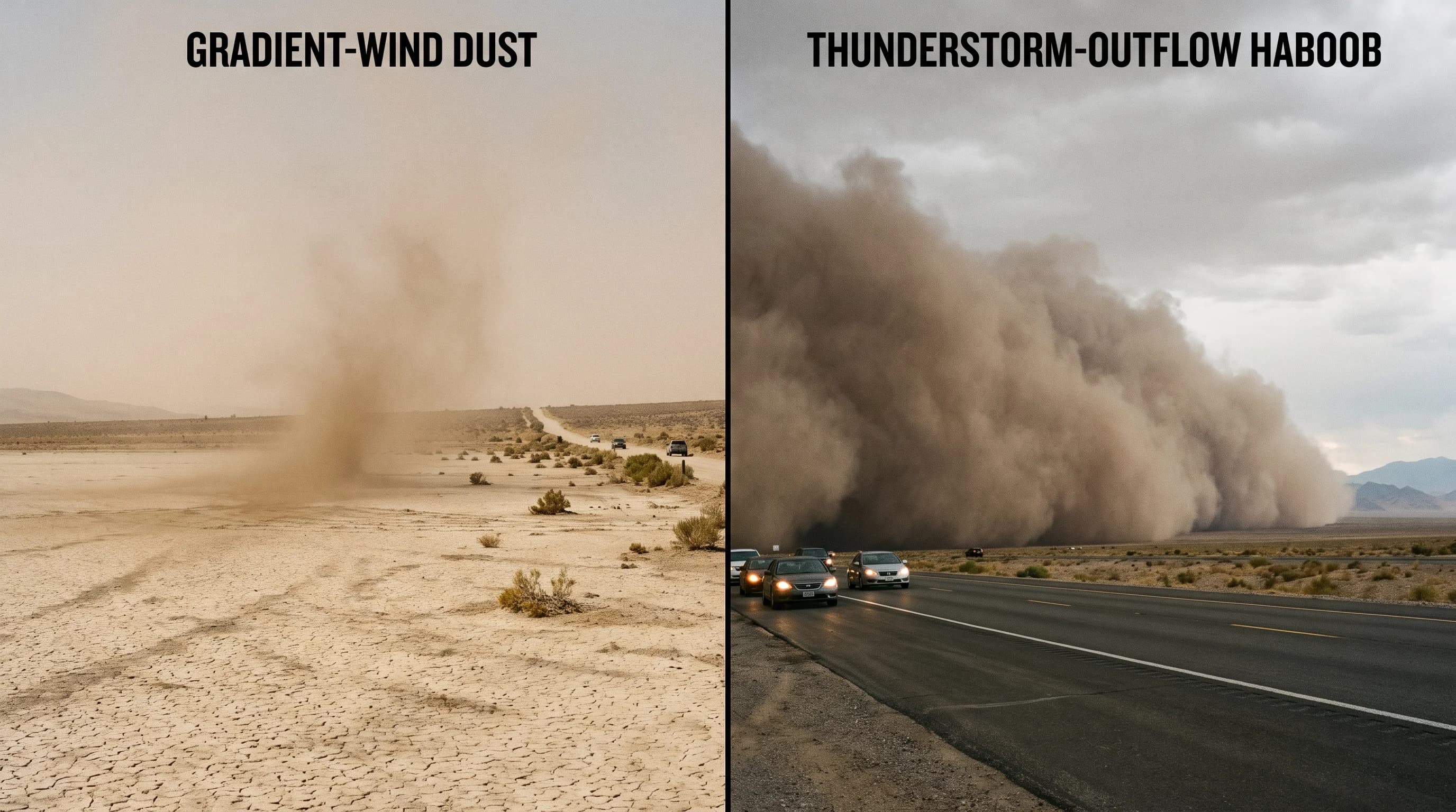
Two formation panels comparing gradient-wind dust from a dry lakebed with a thunderstorm-outflow haboob, labeling loose soil, gust front, and plume direction
Gradient-wind dust events build steadily from sustained desert wind over exposed dry-lake soil, while a haboob forms suddenly from the collapsing outflow of a thunderstorm and arrives as a fast-moving wall of dust.

Where and when are Southern California dust storms most likely?

The Coachella Valley around Palm Springs, Indio, and Desert Hot Springs is one of the most exposed corridors in the region, funneled by the San Gorgonio Pass, which accelerates wind moving between the coastal basin and the desert interior. The Mojave Desert along Interstate 15 near Barstow and the high desert routes through and around Joshua Tree see similar exposure, along with the Imperial Valley along Interstate 8 farther south, both known for dry-lake and agricultural dust sources documented in NWS forecast discussions for those zones.

Timing follows two distinct patterns. Spring, particularly March through May, is the season for gradient-wind dust events, when a strong pressure difference between an inland high and a lower-pressure trough drives sustained wind across the open desert floor for hours at a stretch. Summer brings the North American monsoon into range of the Southern California deserts, and with it the risk of thunderstorm-outflow haboobs, typically from July through September, when isolated storm cells collapse and send gust fronts racing outward across the Coachella and Mojave deserts with little advance notice. Both patterns can occur outside their peak months, so a dry, windy day in any season across these corridors is worth treating as a possible dust risk rather than assuming the calendar rules it out.

Why can road visibility collapse so quickly?

Visibility can collapse in well under a minute because a dust storm typically moves as a defined, localized front rather than settling in as a uniform regional haze. A driver can be in clear desert air one moment and inside a dense plume seconds later as that moving wall of dust crosses the highway, especially where a road runs directly through a known source area like a dry lakebed or an agricultural field. Because the dust is concentrated near its source and carried by a specific wind direction, the contrast between clear air just outside the plume and near-zero visibility inside it can be dramatic and nearly instantaneous, unlike the slower fade of a rolling coastal fog bank.

Caltrans and the National Weather Service give the same core guidance for drivers caught in blowing dust: do not stop in a travel lane. A vehicle stopped in an active lane under zero-visibility conditions is a serious rear-end collision risk, since following drivers may not see it in time even at reduced speed. The recommended response is to slow down well before entering a dust area if one is visible ahead, turn off headlights, which can create a confusing glow that draws other drivers, take your foot off the brake, pull as far off the paved roadway as possible, and stay there with your seatbelt on until visibility improves.

Multi-vehicle pileups have occurred on desert highways, including stretches of I-10 and I-15, when drivers slowed or stopped inside an active dust plume rather than clearing the roadway entirely, which is documented in Caltrans and NWS public safety messaging for these corridors.

How does dust affect air quality?

Blowing desert dust is measured primarily as PM10, coarse particulate matter up to 10 micrometers across, the size category the EPA and local air districts track for this kind of event. Some finer PM2.5 material can also be present, particularly closer to a dust source, but PM10 is the dominant pollutant category tied specifically to windblown soil rather than combustion smoke. Regional air quality management districts, including the South Coast Air Quality Management District and the Mojave Desert Air Quality Management District, monitor and report PM10 levels across the desert basins for exactly this reason.

A fixed air-quality monitor several miles from the road can report normal readings even while a nearby highway or neighborhood sits inside a dense, fast-moving plume, because blowing dust is often narrow and localized rather than evenly spread across a monitoring network's coverage area. A visibly brown or hazy sky is a useful visual warning, but it is not the same thing as a verified pollutant concentration at your specific location. Anyone with asthma, COPD, or other respiratory sensitivity should treat an active Dust Storm Warning or a visible plume as a reason to limit outdoor exposure immediately, rather than waiting for a distant monitor reading to confirm what is already visible outside.

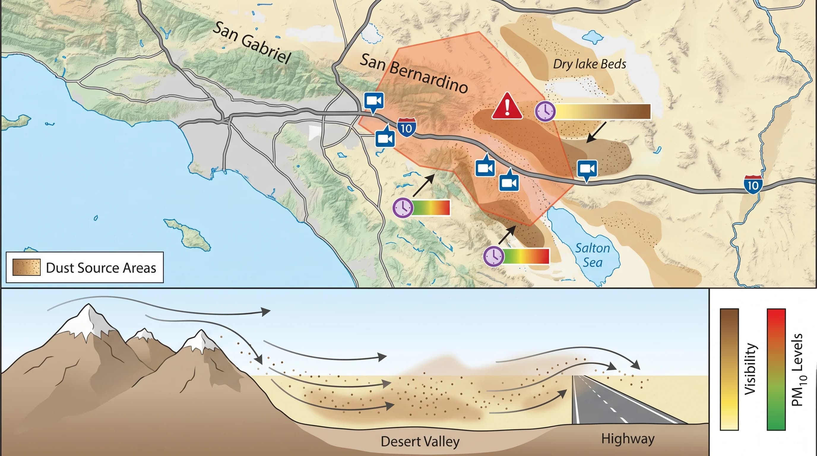
A desert travel map combining exposed dust-source areas, highway camera points, visibility observations, NWS warning polygon, and PM10 monitor timestamps
Checking a route rather than just a destination matters, since a highway can cross a known dust-source area, an active NWS warning polygon, and a PM10 monitor reading that a single-point forecast for a town never shows.

What should hikers and drivers monitor?

Start with the wind forecast for your entire route, not just your endpoint. A trip from Downtown Los Angeles or Pasadena out to Palm Springs or Joshua Tree crosses through the San Gorgonio Pass and open desert corridors well before it reaches the destination town itself, and that pass is often windier than either end of the drive. Check for an active Dust Storm Warning from NWS Los Angeles/Oxnard or NWS San Diego depending on your route, since these are timestamped and zone-specific rather than a single regional blanket alert.

Pair the forecast with Caltrans QuickMap, which shows live highway camera images and road status along I-10, I-15, and other desert corridors prone to blowing dust, and treat any thunderstorm activity in a summer desert forecast as a real possibility of a fast-forming haboob, even if the sky looks clear at your starting point. Southern California's dry offshore wind events, most associated with the fall and winter pattern covered in the Santa Ana winds article, are a related but distinct wind hazard worth understanding alongside desert dust, since both can develop quickly and both call for a route-level check rather than a single destination forecast.

The go-or-wait decision for a desert trip should weigh your entire route's wind and visibility outlook, not just conditions at the town you are heading toward.

What happens if you walk into a dust devil?

A dust devil is a small, rapidly rotating column of wind that lifts loose dust and light debris, usually forming on hot, calm days when uneven heating of the desert floor creates a localized rising column of air. Most dust devils are weak, short-lived, and unrelated to the large-scale dust storms and haboobs described above. Walking into one typically means a brief blast of gritty wind and a few seconds of reduced visibility, similar to walking through an unusually strong gust. Some can sting exposed skin or momentarily stagger a person, but they cover a small area and pass quickly, unlike a dust storm's wider and longer-lasting plume.

A common question is whether a dust devil could pick a person up, and the honest answer is that typical Southern California dust devils are not strong enough to lift an adult off the ground. Their winds are generally comparable to a stiff gust rather than a tornado's rotating wind field. An unusually intense dust devil can topple light, unsecured items such as folding chairs, umbrellas, or small tents, which is a useful sign of how much stronger the rare strong ones can be compared to the average. If one crosses your path, the simplest response is to shield your eyes, turn your back to the wind, and let it pass rather than trying to walk directly through the core.

The short version holds up under scrutiny: Southern California's deserts get real, sometimes fast-forming dust storms, and the highway visibility risk they create is dangerous enough that both Caltrans and the National Weather Service treat it as a standing seasonal hazard rather than a rare curiosity. Before any drive or hike through the Coachella Valley, the Mojave corridor, or the Imperial Valley, check the current wind forecast, any active Dust Storm Warning, and Caltrans QuickMap camera images for your full route on WeatherEscape's Los Angeles pages, and be ready to pull off safely if a wall of dust appears ahead of you. See virga over Southern California deserts and microbursts for two storm processes that can produce sudden outflow and blowing dust.

Frequently Asked Questions

What is a dust storm, and is it a haboob?

A dust storm is any weather event in which strong wind lifts enough loose soil into the air to significantly reduce visibility, sometimes to near zero. A haboob is a specific, more dramatic type of dust storm: a dense wall of dust pushed outward by the collapsing outflow of a thunderstorm, rather than by steady large-scale wind. Southern California sees both. Spring and early summer often bring gradient-wind dust events tied to strong pressure differences across the desert, while summer monsoon thunderstorms can trigger true haboob-style walls of dust across the Coachella and Mojave deserts.

How do desert dust storms form?

Three conditions have to line up: dry, loose soil with little vegetation holding it in place, wind strong enough to break the crust of that soil and lift particles into the air, and enough open fetch, or unobstructed distance, for the wind to gather material as it travels. Dry lake beds, agricultural fields between crop cycles, recently burned hillsides, and other disturbed desert soils are the most common source areas because their surface crust is easiest to break. Not every windy desert day produces a dust storm; the source soil has to be exposed and dry enough to lift in the first place.

Where and when are dust storms most likely in Southern California?

The Coachella Valley around Palm Springs and Indio, the Mojave Desert corridor along Interstate 15 and Interstate 10, and the Imperial Valley see the region's most frequent blowing-dust conditions, tied to the strong pressure gradients and exposed dry-lake terrain in those areas. Spring is the season for gradient-wind dust events, when strong pressure differences push sustained wind across the desert floor for hours at a time. Summer brings a different pattern: monsoon thunderstorms produce sudden outflow winds that can generate haboob-style dust walls with little warning.

Why can road visibility collapse so quickly in a dust storm?

A dust storm often moves as a defined front rather than a uniform haze, so a driver can be in clear air one moment and inside a dense plume seconds later as that front crosses the highway. Because the dust is concentrated in a localized moving mass tied to a specific source area and wind direction, visibility can fall from several miles to a few car lengths in well under a minute. Caltrans and the National Weather Service both advise against stopping in a travel lane if caught in blowing dust, since a stopped vehicle in zero visibility is a serious rear-end collision risk.

How does dust affect air quality?

Blowing desert dust is measured primarily as PM10, particulate matter up to 10 micrometers across, and can also include some finer PM2.5 material. Because a dust plume is often narrow and moves with the wind, a permanent air-quality monitor stationed some distance away can report normal readings even while a nearby road or neighborhood is engulfed. A visibly brown or hazy sky is not the same thing as a verified pollutant concentration, so anyone with respiratory sensitivity should rely on the nearest official monitor reading or a Dust Storm Warning rather than judging air quality by eye alone.

What should hikers and drivers monitor before heading into the desert?

Check the wind forecast and any active Dust Storm Warning from NWS Los Angeles/Oxnard or NWS San Diego for your specific route, not just your destination, since dust source areas can sit well before or after the town you are heading to. Pair that with Caltrans QuickMap for live highway camera images and road status, particularly on I-10, I-15, and other desert corridors known for blowing dust. If thunderstorms are in the forecast for a summer desert trip, treat outflow winds as a real possibility even under otherwise clear skies, since a haboob can form with very little lead time.

What happens if you walk into a dust devil?

A dust devil is a small, rapidly rotating column of wind that lifts loose dust and debris, usually forming on hot, calm days when the ground heats unevenly. Most are weak and short-lived, and walking into one typically means a brief blast of wind, dust in your eyes, and reduced visibility for a few seconds, similar to walking through a gust of grit-filled wind. Some can produce winds strong enough to sting exposed skin or momentarily stagger a person, but they are a different phenomenon from a dust storm or haboob, which cover far more area and last much longer.

Could a dust devil pick you up?

Typical dust devils in Southern California are not strong enough to lift a person off the ground; their winds are usually comparable to a stiff gust rather than a tornado. In rare cases, an unusually intense dust devil can topple light unsecured objects like folding chairs, umbrellas, or small tents, which is a useful sign of how much stronger some can be than the average. There is no credible record of a dust devil lifting an adult, but the safest response if one crosses your path is still to shield your eyes, turn away from the wind, and let it pass rather than trying to walk through the core.

Related Destinations

Live Los Angeles Conditions

Compare temperature, wind, clouds, and comfort across the map.

See which microclimates are clear, cool, windy, smoky, or warming up right now.

Open the Weather Map
Destinations☀️Smog Forecast🌫️Smog Heat Map🔒Privacy Policy📄Terms of Service