fire weathersafetywindsevere weather

Red Flag Warning vs. Fire Weather Watch: SoCal

By WeatherLA|Published |Last updated |10 min read
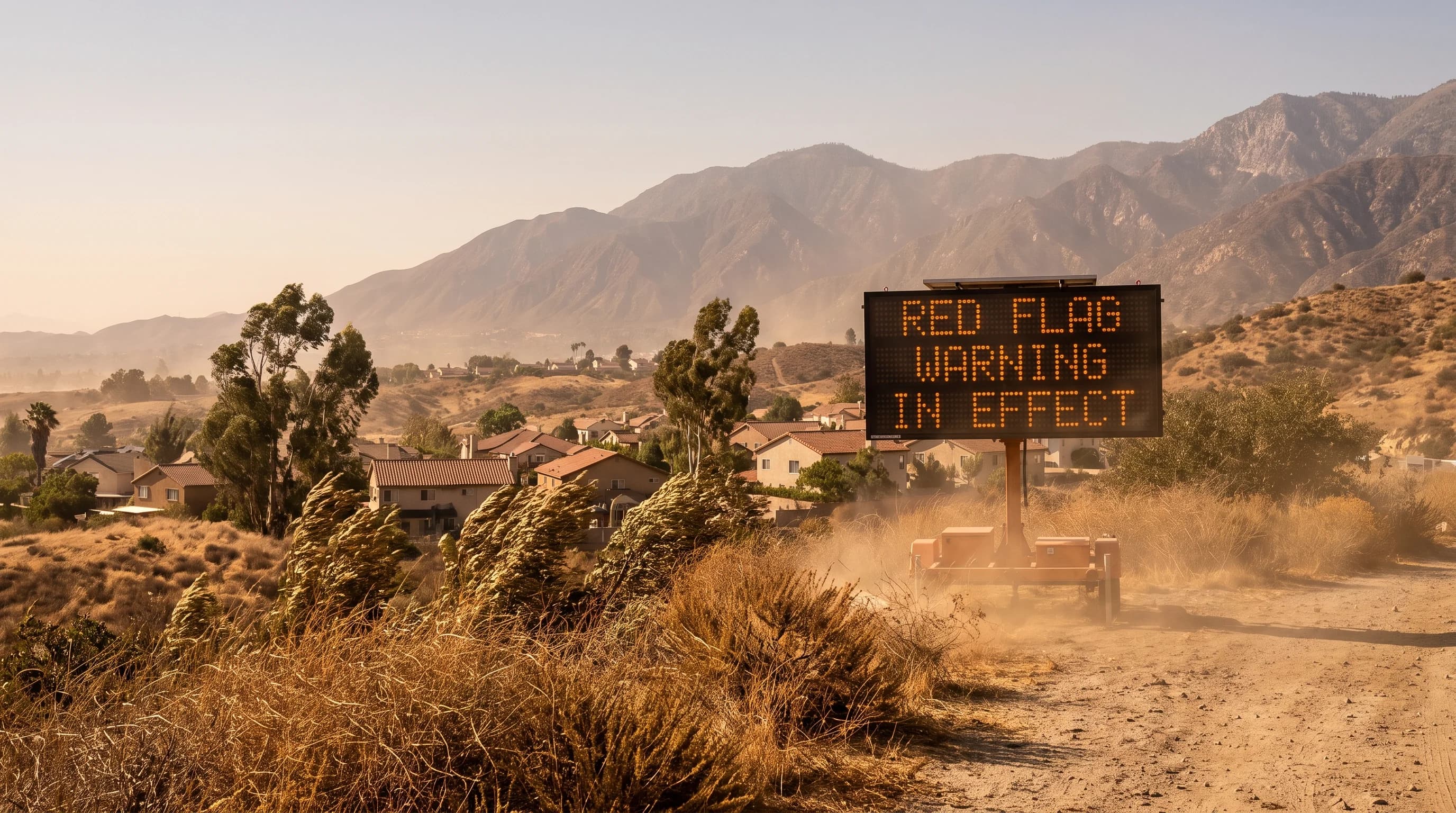
A dry Southern California foothill community under strong offshore wind on a clear day, with no active fire visible, representative of the conditions behind a Red Flag Warning

Key Takeaways

  • A Fire Weather Watch means critical fire-weather conditions are possible in roughly the next 12 to 72 hours; a Red Flag Warning means those conditions are occurring or expected within about 24 hours.
  • Neither product means a wildfire has started. Both describe atmospheric conditions, primarily low humidity and sustained or gusty wind over dry fuels, that would let a new ignition spread quickly.
  • Criteria are set locally by NWS Los Angeles/Oxnard and NWS San Diego for each fire-weather zone, so the humidity and wind thresholds that trigger a warning near the coast can differ from thresholds in the mountains or interior valleys.
  • Santa Ana wind events are a common trigger for Red Flag Warnings in Southern California but are not the only one; monsoon-driven dry lightning and offshore flow outside classic Santa Ana setups can also qualify.
  • A Red Flag Warning is a National Weather Service product. It is separate from a utility Public Safety Power Shutoff and separate from a county or city evacuation order, and each is issued by a different agency for a different reason.
  • During either alert, the practical response is the same: eliminate outdoor ignition sources, secure loose or flammable items outdoors, and confirm you know your evacuation zone before conditions escalate.

A Fire Weather Watch means the National Weather Service believes critical fire-weather conditions are possible in roughly the next 12 to 72 hours. A Red Flag Warning means those conditions are already happening or expected within about 24 hours. The Watch is the earlier, lower-confidence heads-up; the Warning is the shorter-fuse, higher-confidence alert. Neither one means a wildfire has started. Both describe the atmosphere, primarily low humidity and wind blowing over dry fuels, that would let a new ignition spread fast if one occurs. NWS Los Angeles/Oxnard and San Diego issue both products for Southern California, zone by zone, as conditions evolve.

What is the difference between a Fire Weather Watch and Red Flag Warning?

The two products sit on the same escalation ladder but represent different timing and different confidence. A Fire Weather Watch is issued when forecasters see a reasonable chance that critical fire-weather conditions will develop, but the exact timing, location, or intensity is still uncertain enough that the office wants to give residents and fire agencies advance notice to prepare. A Red Flag Warning is issued when those conditions are either already occurring or are considered imminent, generally within the next day, with enough forecast confidence that the office is committing to the alert.

In many events the sequence runs from Watch to Warning as a storm system, wind event, or dry spell firms up on model guidance and observations. In fast-developing situations, NWS can skip straight to a Warning without a preceding Watch.

It is worth repeating because it gets lost in casual conversation: a Red Flag Warning is not a fire alert. It is a weather alert. The National Weather Service does not track active fires, assign containment percentages, or issue evacuation orders. Those responsibilities belong to agencies covered later in this article. What NWS Los Angeles/Oxnard and NWS San Diego are certifying with a Red Flag Warning is that the atmosphere itself, wind, humidity, and fuel dryness, has reached a threshold where any ignition, whether from lightning, equipment, or human activity, is likely to spread rapidly and be difficult to control.

Fire Weather Watch vs. Red Flag Warning in Southern California
FeatureFire Weather WatchRed Flag Warning
What it signalsCritical fire-weather conditions are possibleCritical fire-weather conditions are occurring or imminent
Typical lead timeRoughly 12 to 72 hours aheadGenerally within about 24 hours
Forecast confidenceModerate; timing and intensity still firming upHigh; NWS is committing to the alert
Key ingredients assessedForecast wind, relative humidity, and fuel dryness trending toward zone criteriaWind, relative humidity, and fuel dryness meeting or exceeding zone criteria
Issuing authorityNWS Los Angeles/Oxnard or NWS San Diego, by zoneNWS Los Angeles/Oxnard or NWS San Diego, by zone
What it does not meanA wildfire is confirmed or guaranteed to startA wildfire has started, or that evacuation is ordered

What conditions create critical fire weather?

Critical fire weather is a combination, not a single number. NWS forecasters weigh relative humidity, wind speed and gustiness, and fuel dryness together, since a day that is merely windy or merely dry rarely qualifies on its own. Low relative humidity dries out fine fuels, grass, brush, and small dead branches, so they ignite more easily and burn hotter. Sustained or gusty wind then does two things at once: it feeds more oxygen to a fire and it pushes flames and embers ahead of the main front, a process called spotting, which lets a fire jump roads, firebreaks, and creeks that would otherwise slow it down.

Fuel dryness is tracked through both live fuel moisture, the water content of living vegetation, and dead fuel moisture, the water content of dead branches, grass, and litter on the ground, both of which decline through a rainless Southern California summer and fall.

Lightning adds a separate ignition pathway that does not depend on wind at all. When a thunderstorm produces frequent cloud-to-ground strikes with little accompanying rainfall, commonly called dry lightning, a single strike can ignite dry fuel in a remote area where a fire can burn undetected for hours before anyone reports smoke. The NWS lightning safety program covers the broader hazard, and Southern California's monsoon season, roughly July through September, is the period when this dry-lightning ignition risk is most relevant in the mountains and deserts. There is no single statewide humidity percentage or wind speed that automatically triggers a Watch or Warning everywhere in the region.

NWS Los Angeles/Oxnard and NWS San Diego each maintain their own numeric criteria per fire-weather zone, reflecting how dramatically climate and terrain differ across their coverage areas, which is the subject of the next section.

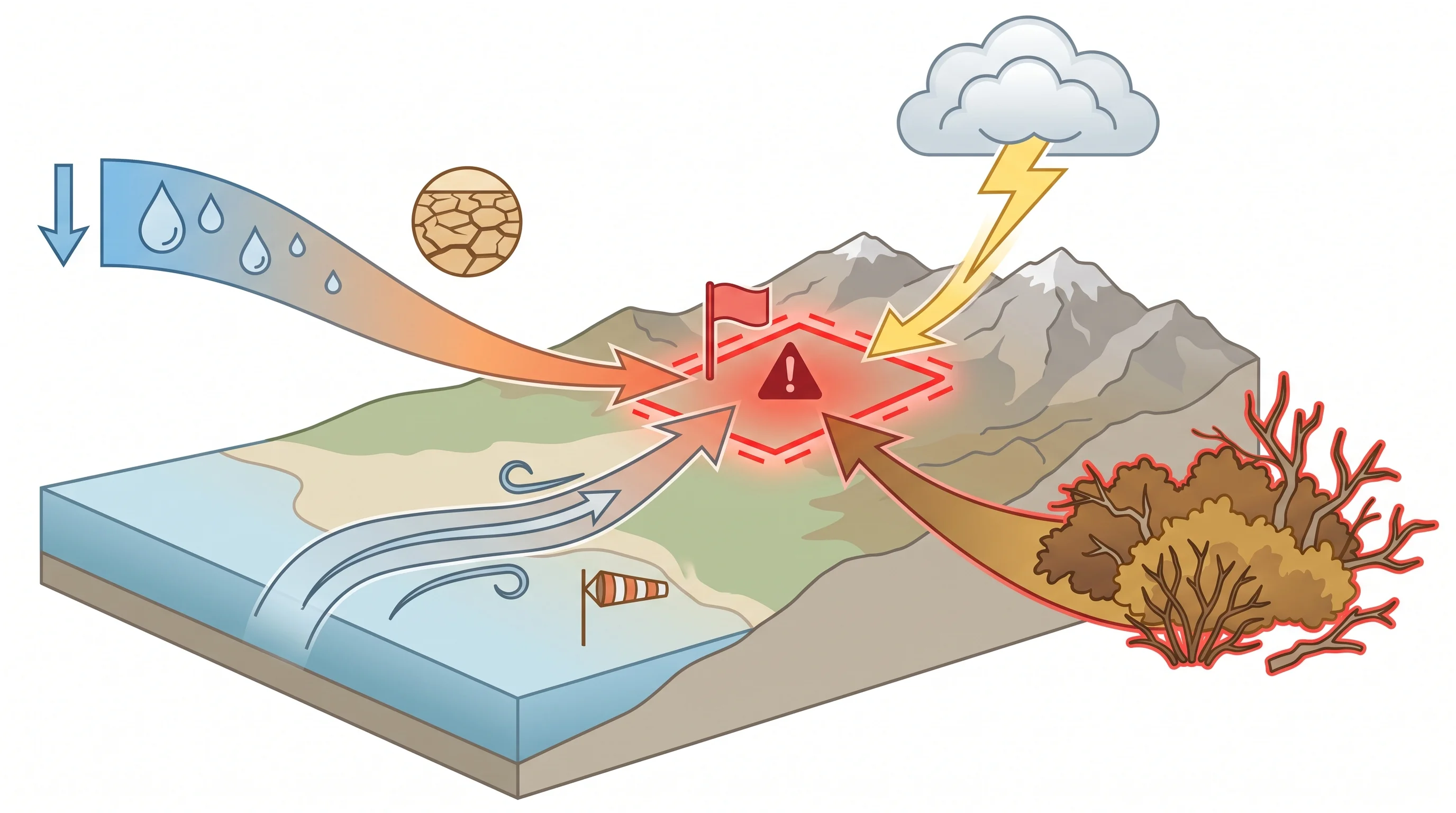
A fire-weather ingredient diagram showing low relative humidity, sustained and gusty wind, dry live and dead fuel, lightning potential, and terrain feeding into a zone-specific Red Flag Warning threshold
Critical fire weather is a combination of ingredients, not one number: low humidity, wind, dry fuel, and sometimes lightning, assessed together against criteria set for each forecast zone.

Why do warning criteria vary by zone?

Warning criteria vary by zone because a humidity or wind reading that would be alarming on the immediate coast is closer to a normal afternoon in the interior valleys or the desert. NWS Los Angeles/Oxnard and NWS San Diego divide their combined coverage area into dozens of individual fire-weather zones that follow terrain, elevation, and typical climate rather than city or county lines. A coastal zone near Downtown Los Angeles typically carries higher baseline humidity thanks to onshore marine influence, so its criteria for a Watch or Warning are calibrated to what counts as genuinely unusual dryness for that specific area.

Interior valleys, foothill zones near Pasadena, and mountain zones at higher elevation run drier on an average day, so their thresholds are set to flag conditions that are unusual even against a naturally drier baseline.

This zone-based approach also accounts for fuel type and season. Grass-dominated foothill zones cure and become flammable earlier in the dry season than brush-dominated chaparral at higher elevation, and desert zones have their own fuel and wind considerations tied to seasonal monsoon activity. Because each local NWS office sets and periodically reviews its own zone criteria, the exact numeric thresholds are not fixed forever and should be checked against the current NWS Los Angeles/Oxnard or NWS San Diego zone forecast rather than assumed from a general rule of thumb.

The practical takeaway for residents is that the headline alert, Watch or Warning, matters more day to day than trying to memorize a specific humidity or wind number, since that number is different for every zone and can change between review cycles.

How do Santa Ana winds fit in?

Santa Ana winds, the dry offshore winds that descend from high pressure over the Great Basin through Southern California's mountain passes and canyons, are one of the most common and most dangerous setups behind a Red Flag Warning in this region. They arrive with the combination critical fire weather needs already built in: sustained or gusty wind, and relative humidity that can drop into the single digits as the descending air compresses and warms. When a Santa Ana event lines up with cured, dry fuels, typically in fall after a long rainless summer, NWS Los Angeles/Oxnard and NWS San Diego often issue Red Flag Warnings across multiple zones at once, since the same offshore wind pattern affects a wide swath of foothill and valley terrain simultaneously.

Santa Ana winds are not the only trigger, though. A dry cold front passing through without much rain can produce gusty post-frontal wind over dry fuels. Offshore flow can develop outside the classic Santa Ana pressure pattern and still dry out the atmosphere enough to qualify. And as covered above, dry lightning from monsoon thunderstorms can prompt a Watch or Warning with comparatively little wind involved at all, particularly in the mountains and deserts during summer. For the full mechanism behind how Santa Ana winds form, why they warm and dry as they descend, and which Los Angeles areas typically see the strongest gusts, see the companion article on Santa Ana winds and Los Angeles fire weather, which covers that mechanism in depth rather than repeating it here.

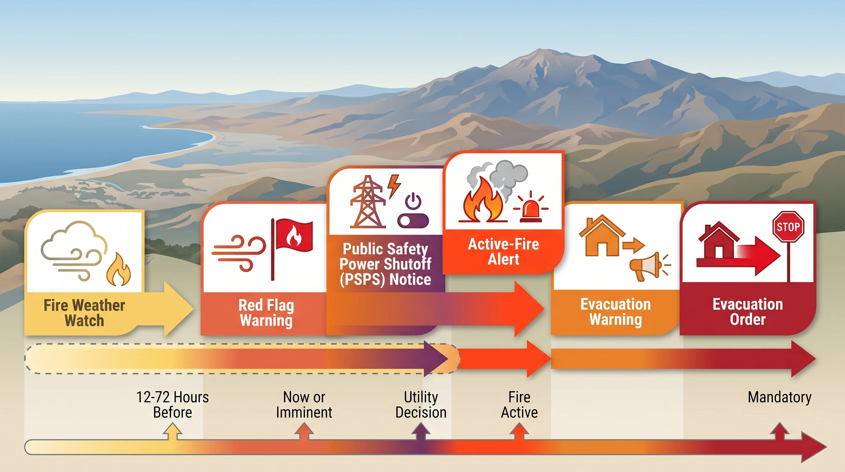
A timeline graphic comparing a Fire Weather Watch, a Red Flag Warning, a utility Public Safety Power Shutoff notice, an active-fire alert, an evacuation warning, and an evacuation order in sequence
A Red Flag Warning, a utility power shutoff, and an evacuation order can overlap during a major event, but each is a separate decision made by a separate agency.

Is a Red Flag Warning the same as a power shutoff or evacuation?

No, and conflating the three is one of the most common sources of confusion during a major wind and fire event. A Red Flag Warning is a National Weather Service forecast product. It describes atmospheric conditions and is issued regardless of whether any utility or local government takes further action. A Public Safety Power Shutoff is a separate decision made by an electric utility, such as Southern California Edison or San Diego Gas & Electric, to de-energize specific power lines in high fire-risk areas in order to prevent equipment, particularly wind-damaged lines and vegetation contact, from becoming an ignition source.

Utilities generally consider Red Flag Warnings and their own internal risk models when deciding where and when to shut off power, but the shutoff itself is the utility's call, not an automatic consequence of an NWS warning.

An evacuation warning or evacuation order is a third, separate decision, issued by a county sheriff, fire department, or local emergency management agency in response to an actual fire or another imminent, specific threat to a defined area. Evacuation decisions depend on fire behavior, terrain, road access, and population density in ways a weather product alone cannot capture. During a serious event, all three can be active in the same area within hours of each other: a Red Flag Warning covering the region, a Public Safety Power Shutoff affecting specific circuits, and an evacuation order for a neighborhood near an active fire. Each is decided by the agency that owns that specific responsibility, and each should be checked from its own official source rather than assumed from the others.

What should residents do during either alert?

The practical response to a Fire Weather Watch and a Red Flag Warning is largely the same, with the Warning simply calling for more urgency because the window is shorter. The NWS wildfire safety guidance and CAL FIRE both emphasize eliminating outdoor ignition sources first: avoid outdoor burning, power tools that can throw sparks, welding or grinding, and towing chains that drag on pavement. Many Southern California cities and counties restrict or prohibit fire pits and other open flame outright during a Red Flag Warning, and those rules are set locally, so check your city or county fire department for current restrictions rather than assuming a statewide rule applies everywhere.

Around the property, secure or bring in anything loose that wind could turn into a hazard, patio furniture, umbrellas, trash cans, and anything that could blow into power lines or block a driveway during an evacuation. Communities in and around Woodland Hills and other foothill and canyon-adjacent areas that see strong Santa Ana gusts should pay particular attention to this step, since wind exposure there tends to run higher than in more sheltered valley and coastal terrain. It is also worth using a Watch, while there is still lead time, to confirm you know your evacuation zone and have a go-bag and a plan ready, rather than trying to look it up for the first time after a Warning is already in effect or a fire has started nearby.

This article covers the weather-alert system itself: what NWS Los Angeles/Oxnard and NWS San Diego mean by each product and how to interpret one when it appears in a forecast. It does not carry live, timestamped conditions or replace incident-specific guidance once a fire is actually burning. For related fire-weather phenomena that can appear during these events, see the companion explainers on fire whirls and pyrocumulus clouds, both of which describe how an active wildfire can generate its own extreme local weather.

Before a critical fire-weather period begins, check your destination's current wind, gust, and humidity forecast on WeatherEscape's Los Angeles pages, confirm whether a Watch or Warning is in effect for your zone, and look up any utility power shutoff notices or local emergency alerts for your specific area rather than relying on regional headlines alone.

Frequently Asked Questions

What is the difference between a Fire Weather Watch and Red Flag Warning?

A Fire Weather Watch means the National Weather Service believes critical fire-weather conditions, typically a combination of low humidity, sustained or gusty wind, and dry fuels, are possible over the next roughly 12 to 72 hours. A Red Flag Warning is the higher-confidence, shorter-fuse product: it means those critical conditions are either occurring or expected within about 24 hours. In practice, a Watch is upgraded to a Warning as forecast confidence increases and the event gets closer, though NWS can also issue a Warning directly if conditions develop quickly. Neither product means a fire has ignited.

What conditions create critical fire weather?

Critical fire weather in Southern California typically combines low relative humidity, sustained or gusty wind, and fuels that are dry enough to carry fire easily, often assessed through live and dead fuel moisture measurements. NWS Los Angeles/Oxnard and NWS San Diego also weigh instability and the potential for dry lightning, since a lightning strike with little or no rain can ignite fuels without any warning at all. There is no single statewide humidity or wind number that triggers a warning everywhere; each forecast zone has its own criteria set by the local office.

Why do warning criteria vary by zone?

NWS Los Angeles/Oxnard and NWS San Diego divide their coverage areas into fire-weather zones because climate, fuel type, and elevation differ sharply across Southern California. A coastal zone with typically higher humidity needs a different threshold to represent genuinely critical conditions than an interior valley or mountain zone that runs drier on an average day. Setting criteria per zone lets each office issue a Watch or Warning only when conditions are actually unusual and dangerous for that specific area, rather than applying one generic number across very different terrain.

How do Santa Ana winds fit in?

Santa Ana winds, the dry, offshore winds that descend from the Great Basin through Southern California mountain passes, are one of the most common and most dangerous setups behind a Red Flag Warning, because they combine strong wind with very low humidity over already-dry fuels. They are not the only trigger. Warnings can also be driven by dry cold fronts, offshore flow outside a classic Santa Ana pattern, or monsoon moisture that produces dry lightning without meaningful rainfall. The mechanics of how Santa Ana winds form are covered in depth in a companion article on Santa Ana winds and Los Angeles fire weather.
Is a Red Flag Warning the same as a power shutoff or evacuation?

No. A Red Flag Warning is a National Weather Service forecast product describing atmospheric fire-weather conditions. A Public Safety Power Shutoff is a decision made by an electric utility, such as Southern California Edison or San Diego Gas & Electric, to de-energize lines in high-risk areas to reduce ignition risk from equipment. An evacuation warning or order is issued by a county sheriff, fire department, or local emergency management agency in response to an actual fire or imminent threat. The three can overlap during a major event, but each is decided and announced separately by the agency that owns that decision.

How do Santa Ana winds and dry fuels contribute to Red Flag Warning conditions?

Santa Ana winds supply the wind and humidity side of the equation, often dropping relative humidity into the single digits while producing sustained gusts through passes and canyons. Dry fuels supply the other half: vegetation that has cured through a rainless summer and fall carries fire far more readily than fuel with normal moisture content. When both align, an offshore wind event over already-dry vegetation, NWS forecasters have the ingredients for the kind of fast-moving fire spread that a Red Flag Warning is meant to flag in advance.

Can you use a fire pit during a Red Flag Warning?

Local and county fire authorities, not the National Weather Service, set outdoor burning rules, and many Southern California jurisdictions restrict or ban outdoor fires, fire pits, and other open flame during a Red Flag Warning. Because rules vary by city and county, check your local fire department or county fire authority for current restrictions before lighting anything outdoors during a Watch or Warning, and avoid any activity that could throw a spark, including power tools, grinding, and towing chains that drag on pavement.

Does a Fire Weather Watch mean a fire is likely to start?

A Fire Weather Watch describes the atmosphere, not the presence of a fire. It means conditions capable of rapid fire spread are becoming possible, so any ignition that does occur, whether from lightning, equipment, or human activity, would likely spread quickly. It is a planning window to reduce ignition risk and prepare, not a statement that a fire has started or is guaranteed.

Related Destinations

Live Los Angeles Conditions

Compare temperature, wind, clouds, and comfort across the map.

See which microclimates are clear, cool, windy, smoky, or warming up right now.

Open the Weather Map
Destinations☀️Smog Forecast🌫️Smog Heat Map🔒Privacy Policy📄Terms of Service