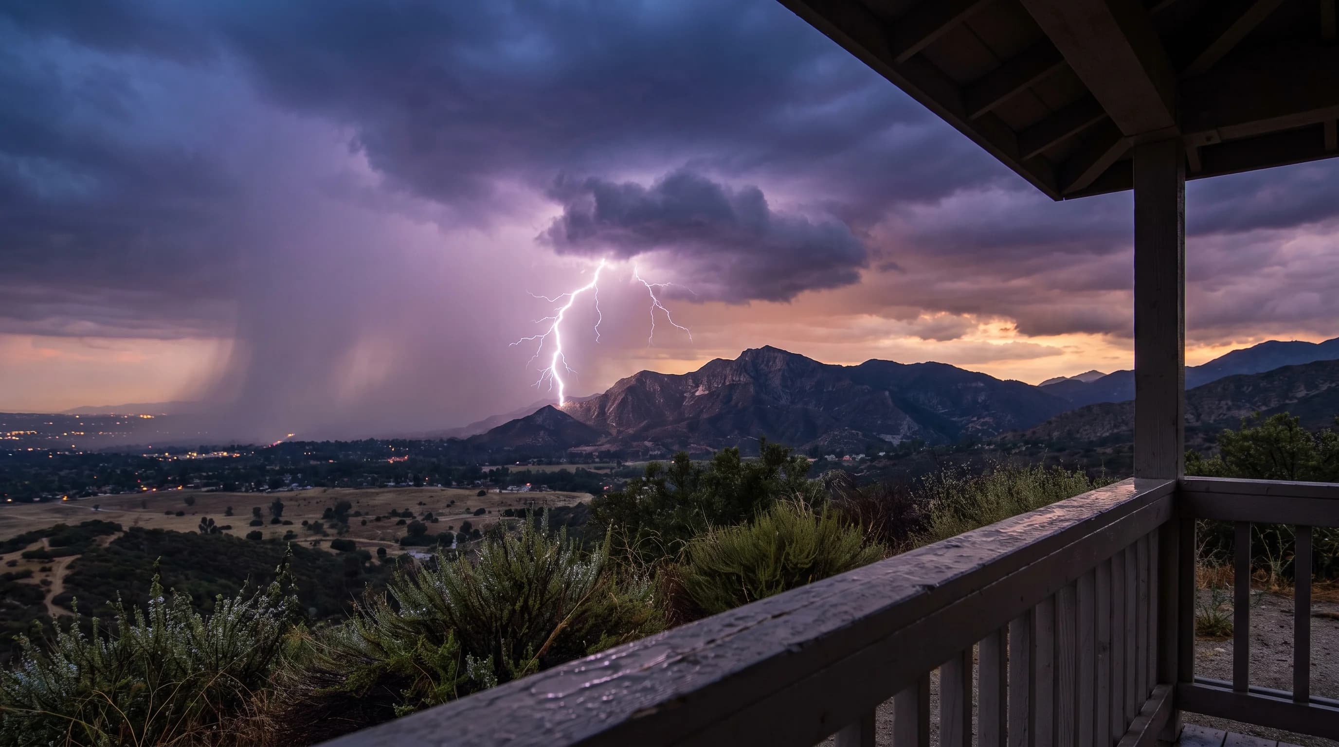
Lightning forms when collisions between ice crystals, graupel and supercooled water droplets inside a growing thunderstorm separate electric charge into positive and negative regions. When the electric field between those regions, or between the cloud and the ground, overcomes the air's resistance, it discharges as a bolt that can reach 50,000°F, hotter than the surface of the sun. Southern California gets lightning far less often than the Great Plains or Florida, because it rarely has the deep, strong updrafts that build a fully charged storm. When a strong storm forms over the mountains or deserts, the physics is the same as anywhere on Earth.
How Does a Storm Separate Electrical Charge?
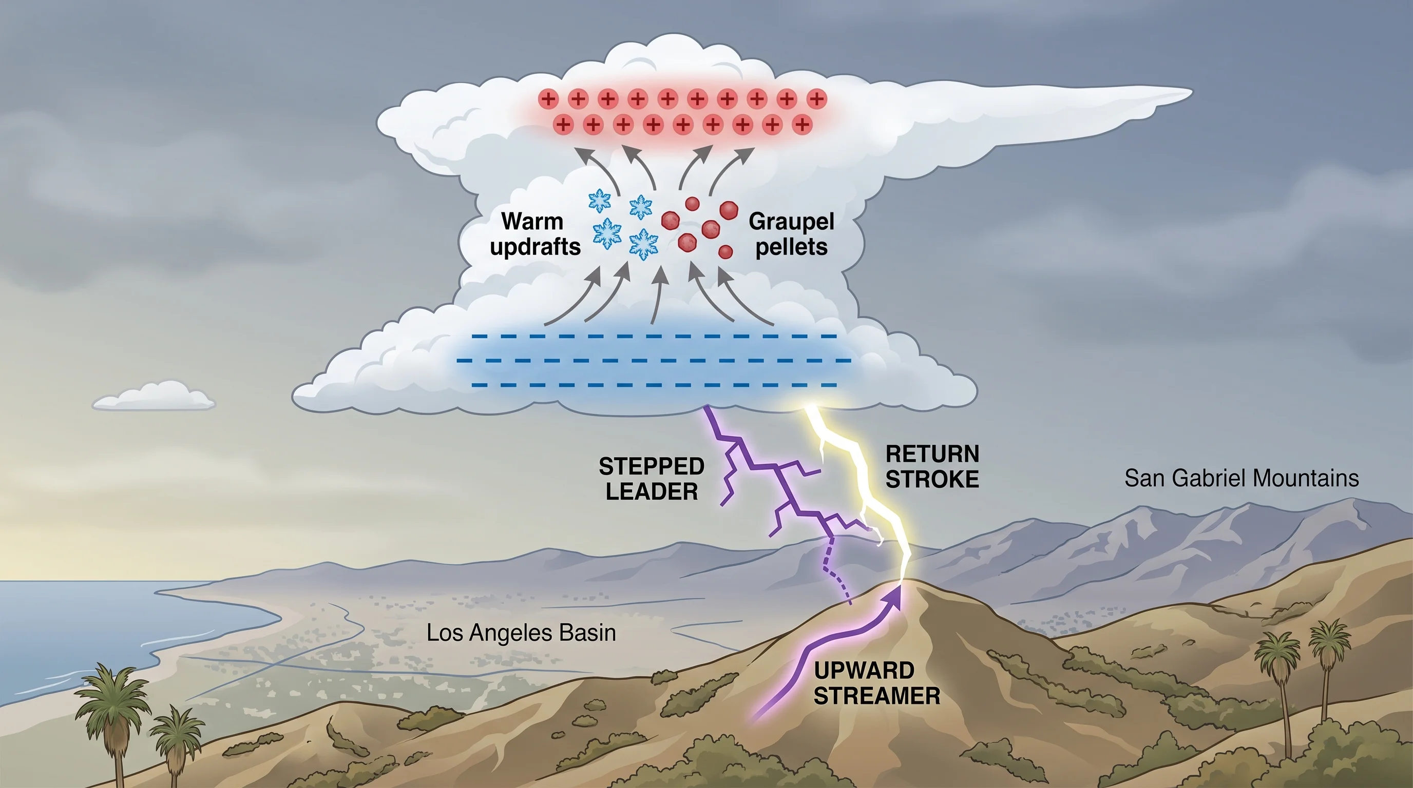
A storm separates electric charge through billions of tiny collisions in its coldest layers. A strengthening updraft carries supercooled water droplets, ice crystals and soft ice pellets called graupel into the same turbulent zone, usually between about 14,000 and 30,000 feet, well below freezing. When rising ice crystals collide with heavier, slower-falling graupel, electrons transfer between them. In that temperature range, graupel usually ends up negatively charged and the lighter ice crystals positively charged, according to research summarized by NOAA JetStream.
The updraft lifts light particles more easily than heavy ones, so the two types separate by weight. The light, positively charged ice crystals rise toward the top and front of the storm, while the heavier, negatively charged graupel stays lower. Millions of collisions sort the storm into a rough stack: positive charge near the anvil top, negative charge in the middle and often a smaller positive pocket near the base.
The ground responds too. As negative charge grows overhead, positive charge builds on the surface below, setting up the electric field that eventually connects cloud and ground. For the full life cycle of a storm cloud, see how thunderstorms form.
| Stage | What happens | Approximate speed or duration |
|---|---|---|
| Charge separation | Ice crystal and graupel collisions build stacked charge regions in the storm | Builds over the storm's growth, minutes to tens of minutes |
| Stepped leader | A faint, negatively charged channel steps downward from the cloud in short bursts | Roughly 200,000 mph in ~50-yard steps |
| Upward streamer | A positively charged channel rises to meet the leader from a tall or grounded object below | Triggered in the final tens of yards |
| Return stroke | Once the channels connect, the visible, brilliant flash surges upward along the completed path | About 270,000,000 mph (roughly one-third light speed) |
| Repeated pulses | Additional strokes can reuse the same channel, producing the flicker seen in a single flash | Often 3-4 strokes in well under a second |
How Does a Cloud-to-Ground Strike Develop?
A cloud-to-ground strike develops when two channels meet in midair, not as one bolt shooting down. It starts with a stepped leader, a faint, negatively charged channel of ionized air that descends from the cloud in short jumps of about 50 yards, pausing briefly between steps. When the leader gets within a few hundred feet of the ground, its strong electric field pulls up a positively charged upward streamer from the tallest or most conductive object nearby, such as a tree, a radio tower or a person in the open.
When the leader and streamer connect, they complete a path between cloud and ground. The return stroke follows instantly: the brilliant flash people call lightning races back up the channel at about a third of the speed of light, releasing the stored charge and the heat that makes thunder. One flash often includes three or four return strokes through the same channel in quick succession, which is why lightning seems to flicker. The whole sequence takes well under a second.
Why Can Lightning Strike Outside the Rain?
Lightning strikes outside the rain because a storm's charge regions extend beyond its heaviest rain. The positive charge region often sits in the anvil top, which can stretch miles downwind of the storm core. The electric field connecting that charge to the ground does not stop at the edge of visible rain. The result is a "bolt from the blue," a strike that seems to come from clear sky after traveling sideways from a storm's overhanging anvil.
The National Weather Service documents strikes 10 miles or more from a storm's rain core. That is why its guidance says to take shelter as soon as you hear thunder, not when the rain arrives.
Hikers on exposed ridges in the San Gabriel or San Bernardino Mountains face this directly: a storm several miles away can strike under blue sky. Outrunning the rain does not keep you safe. For what to do when you hear thunder, see lightning safety in Southern California.
When Does Southern California Get Lightning?
Southern California gets lightning in three patterns, none like the Great Plains thunderstorm season. The most reliable is the North American monsoon, which pulls moisture north from Mexico and the Gulf of California into the mountains and deserts, mostly from July through September. Monsoon moisture fuels afternoon and evening storms over the San Gabriel and San Bernardino Mountains and desert ranges near Big Bear Lake, where elevation and heating build strong updrafts. That is why July and August are wetter than June in Big Bear; see Big Bear Lake weather by month.
The second pattern is cool-season thunderstorms, when an unusually cold, unstable upper-level low in fall, winter or spring sparks isolated storms, sometimes reaching the coast and the Los Angeles Basin. The third and rarest is a tropical remnant, when moisture from a fading eastern Pacific hurricane or tropical storm reaches Southern California. A tropical remnant can bring more widespread lightning than either seasonal pattern.
In all three patterns, Southern California lightning happens mostly in the mountains and deserts, not the coast or basin. Downtown Los Angeles and Pasadena hear thunder on only a handful of days most years, while the high country hears it routinely each summer. For how often each part of the region gets thunderstorms, see how rare are LA thunderstorms.
What Happens When Lightning Hits Sand, a Car, or a House?
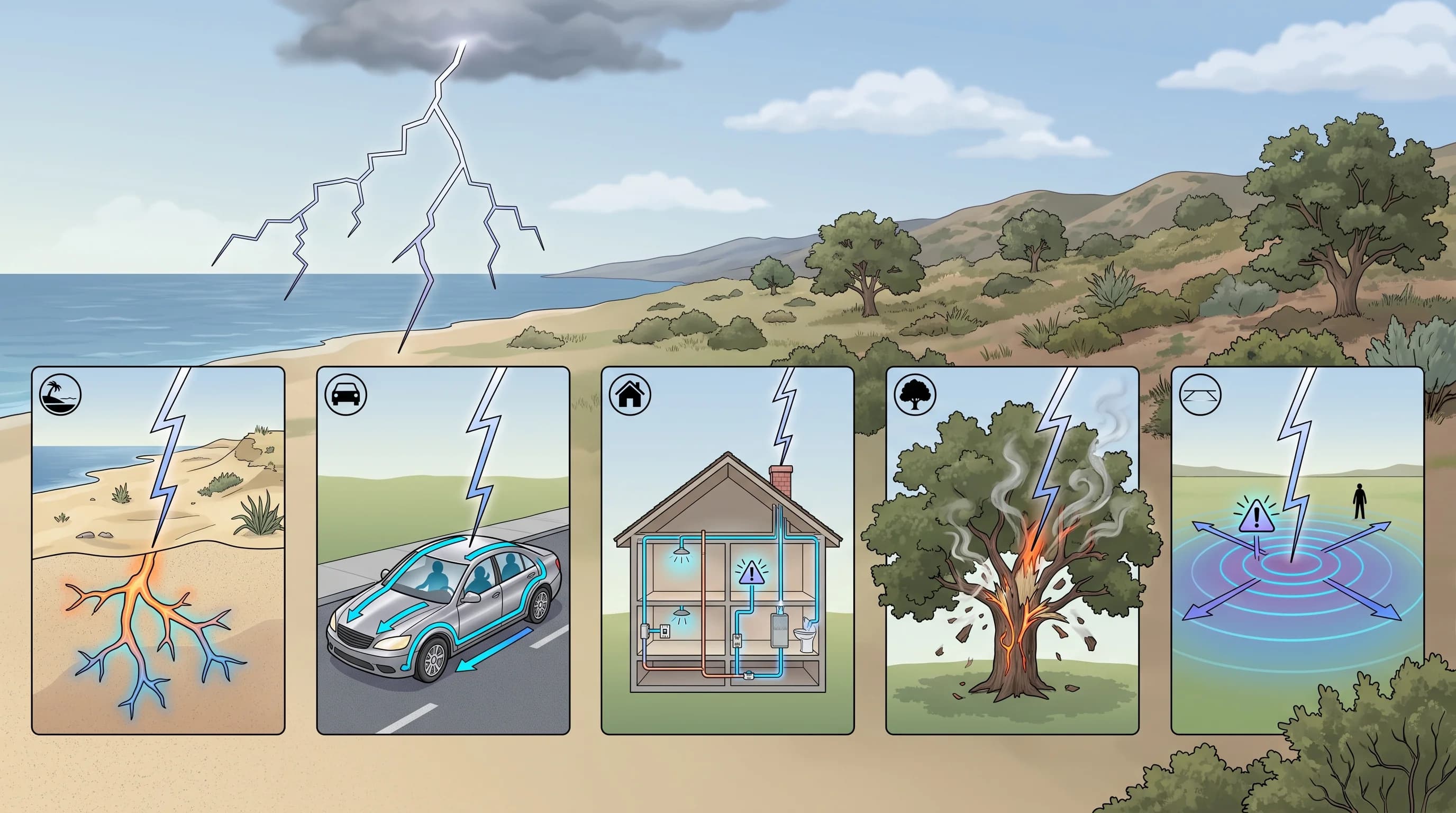
Lightning striking dry sand can fuse it into a hollow, branching glass tube called a fulgurite. The bolt's heat, often near 50,000°F, instantly melts sand along the current's path underground. A strike on a hard-topped car is survivable because the metal shell acts as a Faraday cage, carrying current around the occupants into the ground. The rubber tires do not protect anyone; that is a myth.
A strike on a house usually follows plumbing, wiring or metal ductwork. That is why the National Weather Service advises avoiding corded phones, wired electronics and running water during a storm, even indoors.
Open ground carries its own hazard. Current spreading from a strike point across the ground creates a voltage difference called ground current or step voltage.
Two feet planted a stride apart can sit at different voltages and send current through a person's body without a direct hit. That is one reason open beaches and exposed ridges are dangerous during storms. For where to shelter and how long to wait, see lightning safety in Southern California.
Why Is Thunder So Loud?
Thunder is loud because lightning heats the air in its channel to about 50,000°F in a few millionths of a second, far faster than the air can expand smoothly. The air explodes outward as a shockwave that becomes the crack or rumble of thunder. A sharp crack usually means a close strike. A long rumble usually comes from a distant strike echoing off terrain or from a long channel whose segments sit at different distances from you.
Light arrives almost instantly, and sound travels about one mile every five seconds, so counting from flash to thunder gives a rough distance. That count is the basis for the rule described below.
Can Airplanes Get Struck by Lightning?
Commercial airplanes are struck by lightning about once per aircraft per year of service, and they are built for it. An airplane's aluminum or conductive composite skin works like a car's metal shell, carrying current around the outside of the fuselage and releasing it from a wingtip or tail static wick. The current does not pass through the cabin or critical systems.
Modern aircraft carry certified lightning protection for fuel tanks, wiring and avionics, because strikes are a routine part of flying near thunderstorms. Pilots and air traffic controllers still route around the most active storm cells when possible.
What Is the 5 Second Rule for Lightning?
The 5-second rule says that for every five seconds between a lightning flash and its thunder, the storm is about one mile away, because sound travels about 1,100 feet per second and light arrives almost instantly. The National Weather Service treats the count as a rough distance estimate, not a safety threshold. Its guidance is simpler: if you can hear thunder at all, you are within striking range, so get to real shelter immediately.
What Should You Do When Thunder Begins?
When thunder begins, move to substantial shelter: a fully enclosed building with wiring and plumbing, or a hard-topped vehicle with the windows up. Picnic pavilions, tents and open-sided shelters do not protect you. The National Weather Service 30-30 guideline adds timing: if thunder follows the flash within 30 seconds, take shelter immediately, and wait at least 30 minutes after the last thunder before going back out. A departing storm can still send a bolt from the blue after the rain moves on.
Crouching in an open field, once widely taught, does not substitute for shelter; it lowers your height but does not protect against ground current or a direct strike. For guidance specific to San Gabriel ridge hikers and coastal beachgoers, including where to find real shelter, see lightning safety in Southern California.
Lightning is rare enough in Southern California that many residents never learn how it works, but a monsoon storm over Woodland Hills or the San Bernardino Mountains uses the same charge separation, stepped leader and return stroke as a Plains supercell. Before heading into the mountains or desert in storm season, check radar, lightning data and National Weather Service warnings on WeatherLA's Los Angeles forecast pages. Treat thunder, not rain, as the signal to take shelter.