severe weatherclimate sciencephenomenasummer

Why LA Rarely Gets Thunderstorms

By WeatherLA|Published |Last updated |10 min read
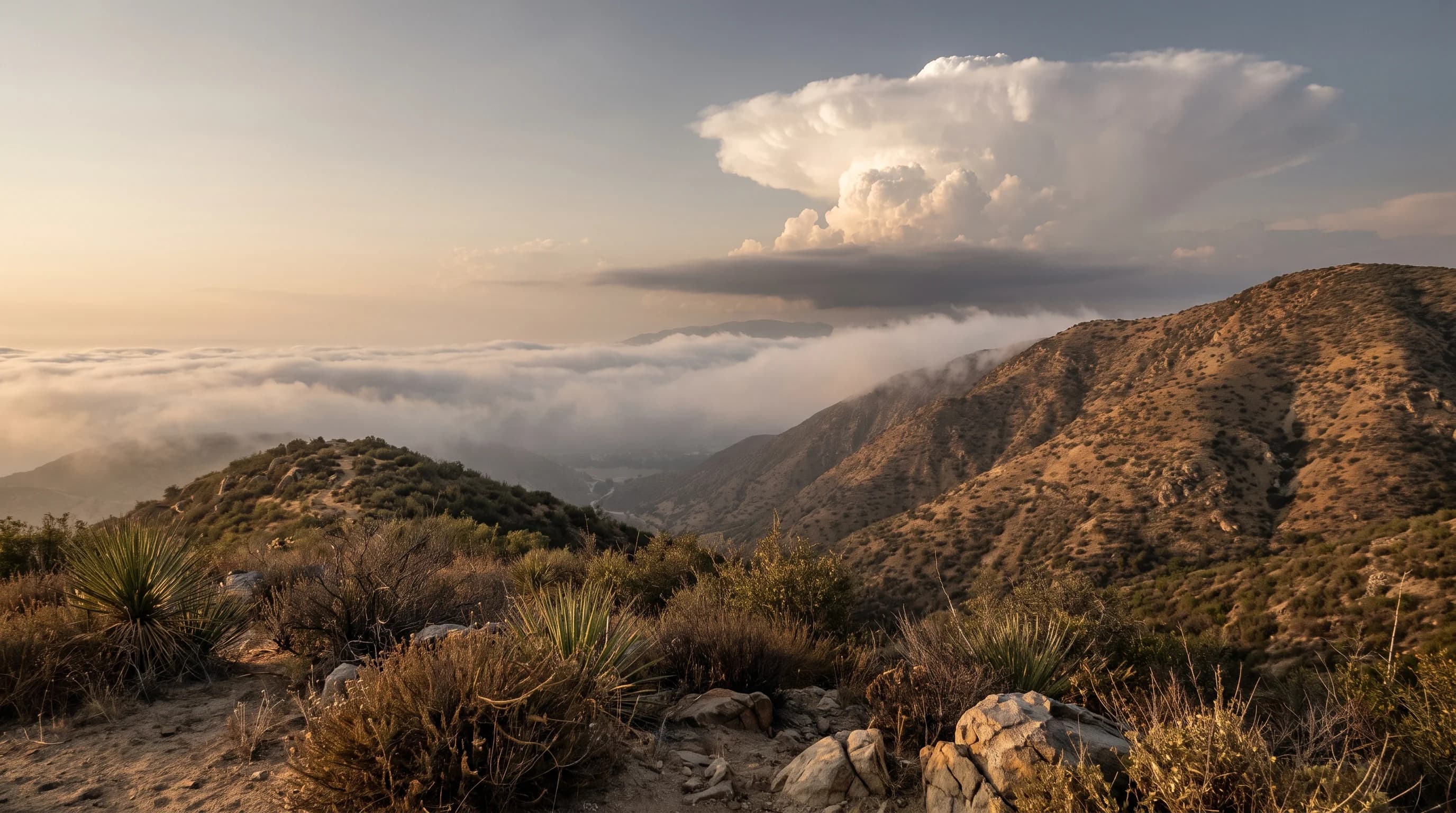
A modest thunderstorm building over the San Gabriel Mountains while stable marine air keeps the Los Angeles coast mostly cloud-layered and storm-free

Key Takeaways

  • A thunderstorm requires three ingredients stacked together at the same time: moisture in the low levels, instability that lets a rising air parcel keep accelerating upward, and a lifting trigger to start that rise in the first place.
  • Coastal Los Angeles usually has only one or two of the three ingredients on any given day. The cool Pacific marine layer caps instability even when heat and moisture are present, which is why summer, the peak thunderstorm season nearly everywhere else in the country, is actually one of the quietest seasons at the LA coast.
  • A tall, hard-edged cumulus tower is not automatically a thunderstorm. It only earns that name once ice forms high in the cloud, separates electrical charge, and produces lightning, a distinct later stage of the same lifecycle.
  • The San Gabriel and San Bernardino Mountains and the deserts beyond them see far more thunderstorm activity than the coast, mainly because daytime heating over high terrain and monsoon moisture from July through September solve the instability and moisture problems the coast cannot.
  • A dry thunderstorm produces lightning and gusty outflow winds with little or no rain reaching the ground, because the rain evaporates in a deep dry layer below the cloud, a pattern that is a leading wildfire ignition risk in Southern California chaparral and mountain forest.
  • Thunder is the safety signal, not a phone alert. If you can hear thunder at all, per National Weather Service guidance, the lightning threat is already close enough that you should be indoors or in a hard-topped vehicle.

Thunderstorms form when three ingredients stack together in the same place at the same time: moisture to feed the cloud, instability that lets rising air keep accelerating upward, and a lifting trigger to start that rise. Coastal Los Angeles usually has only one or two of the three on any given day, because the cool Pacific marine layer caps instability even when heat and moisture are present. That single missing leg, not a lack of storms in general, is the real reason thunder is rare at the beach and routine an hour inland over the mountains.

What three ingredients does a thunderstorm need?

Every thunderstorm, anywhere in the world, depends on the same three ingredients arriving together: moisture, instability, and lift. Moisture is water vapor in the lower atmosphere, the raw material that condenses into cloud droplets and eventually rain. Instability describes how a rising bubble, or parcel, of air behaves once it starts climbing: if that parcel stays warmer, and therefore less dense, than the surrounding air around it as it rises, it keeps accelerating upward under its own buoyancy, the way a cork released underwater keeps rising on its own.

Lift is the trigger that gets a parcel moving in the first place, whether that is sun-heated ground pushing air upward, a cold front shoving warm air out of the way, converging winds forcing air to rise where they meet, or a mountain slope physically deflecting wind upward.

None of the three substitutes for the others. A hot, muggy afternoon with abundant moisture and instability produces nothing without a trigger to start the lift. A strong cold front supplies plenty of lift but produces only rain, not thunder, if the air mass it is pushing into is too dry or too stable to build a tall cloud. This is the core reason Southern California can have scorching, humid days near the coast with no storms at all: the region frequently has the heat, and sometimes the moisture, but the marine layer blocks the instability every thunderstorm actually needs.

The Three Thunderstorm Ingredients: LA Basin vs. Mountains and Desert
IngredientLA coast and basinSan Gabriel/San Bernardino Mountains and desert
MoistureOften limited at storm-relevant levels; onshore flow rarely carries monsoon moisture to the immediate coastRegularly available July through September when monsoon surges push moisture north from Mexico
InstabilityUsually capped by the marine layer inversion, even on warm, humid daysFrequently strong, driven by intense daytime heating over high terrain and desert surfaces
LiftMainly from passing cold fronts or upper-level lows in the cooler monthsMountain slopes and daytime heating provide reliable local lift most summer afternoons
Typical resultOnly a handful of thunder days per year at low elevationRoutine summer afternoon storms, especially in monsoon season

How does a cumulus cloud become a thunderstorm?

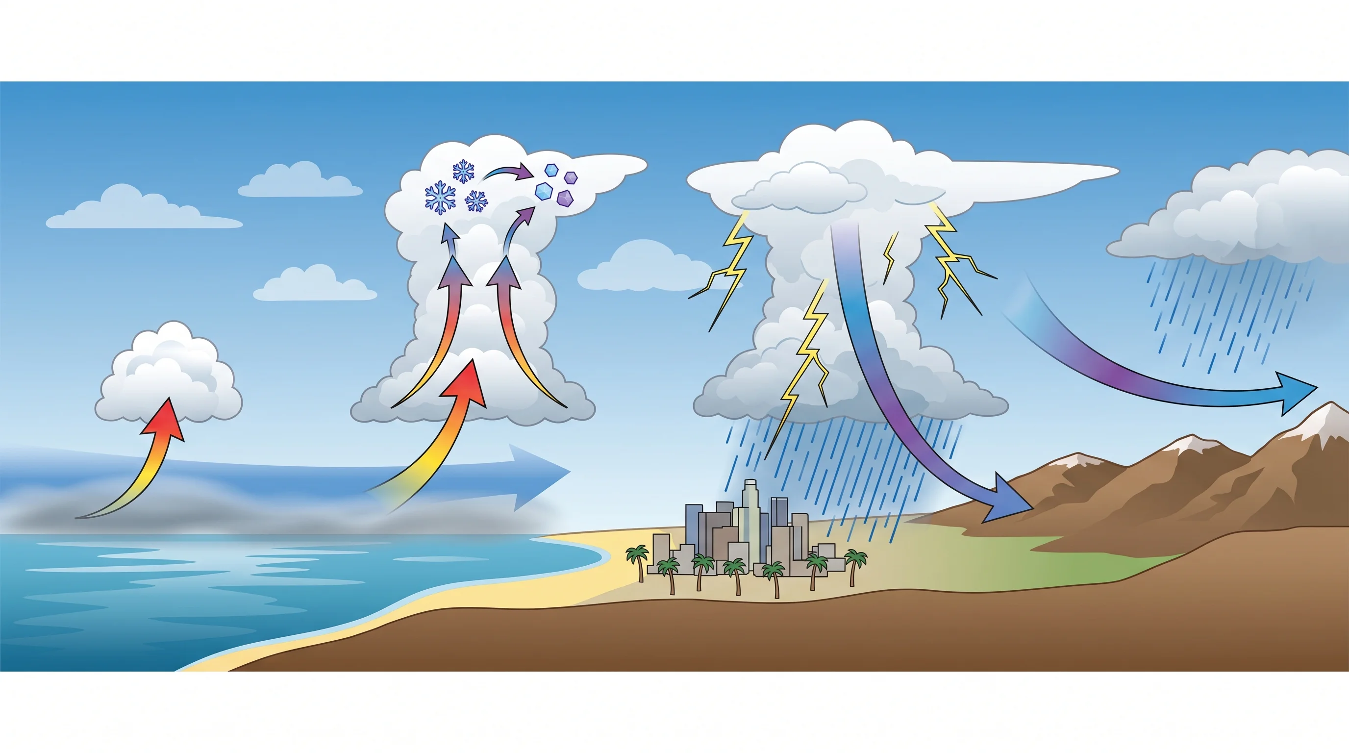
A thunderstorm develops in stages, and a cloud has to pass through every one of them before it earns the name. It starts when a rising parcel cools enough for its water vapor to condense into visible droplets, marking the base of a small cumulus cloud. If instability keeps the parcel buoyant, the cloud keeps building upward into a taller, harder-edged tower called cumulus congestus, the stage most people picture when they imagine a storm forming. Height alone does not make it a thunderstorm yet.

The defining step happens higher up, once the top of that tower pushes into layers cold enough, typically well below freezing, for ice crystals and a dense, rimed ice pellet called graupel to form. Collisions between the rising ice crystals and the heavier, falling graupel transfer electrons between them, sorting the cloud into separate regions of positive and negative charge. Only once that charge separation builds enough to discharge as lightning has the cloud actually become a thunderstorm, technically termed a cumulonimbus cloud. From there the storm matures: rain and hail fall through the cloud, dragging cool air down with them to form a downdraft, which spreads out at the surface as a gust front.

That outflow can undercut the storm's own inflow of warm, moist air, eventually cutting off its fuel supply and causing the storm to weaken and dissipate, often within 30 to 60 minutes for a single-cell storm.

This lifecycle explains a common point of confusion: a tall, dramatic-looking cloud tower is not automatically dangerous or even electrically active. It can run out of instability, get sheared apart by upper-level winds, or simply never reach the cold layers needed for ice to form, in which case it never produces lightning at all. Only the appearance of actual lightning and thunder confirms a cloud has crossed from cumulus congestus into a true thunderstorm, a distinction covered in more mechanical detail in what causes lightning.

A lifecycle diagram of a thunderstorm showing a buoyant air parcel rising through cumulus growth, ice crystals and graupel colliding near the cloud top to separate charge, a mature stage with rain and a lightning strike, a downdraft spreading outward at the surface, and a final dissipating stage
A thunderstorm passes through distinct stages: a rising parcel builds a cumulus tower, ice collisions high in the cloud separate charge until lightning fires, rain and downdrafts mark the mature stage, and the storm dissipates once its own outflow cuts off its warm, moist inflow.

Why are thunderstorms uncommon near coastal Los Angeles?

The cool California Current keeps a shallow layer of moist ocean air, the marine layer, sitting over the LA coast and basin for most of the year, trapped beneath a temperature inversion where the air actually warms with height instead of cooling. That inversion acts like a lid: a parcel of air trying to rise through it runs into warmer air above and immediately loses the buoyancy a thunderstorm needs to keep building. The same inversion responsible for the region's persistent low coastal cloud cover and summer gray is what keeps the coast thunderstorm-poor even during warm, humid stretches.

This is why summer, the season when thunderstorms peak almost everywhere else in the country, is actually one of the quietest seasons at the LA coast. Onshore flow off the cool Pacific rarely carries the monsoon moisture that fuels inland storms all the way to the immediate coastline, and even when humidity climbs, the marine inversion usually keeps the atmosphere too stable to convert that moisture into a storm. Southern California is not thunderstorm-free, though. Coastal storms do occur, mostly in the cooler months when a passing cold front or an upper-level low pressure system can temporarily punch through the stability the marine layer otherwise provides. The National Weather Service Los Angeles/Oxnard office tracks these events and is the authoritative source for local thunderstorm climatology and any specific historical count.

When and where are local storms more likely?

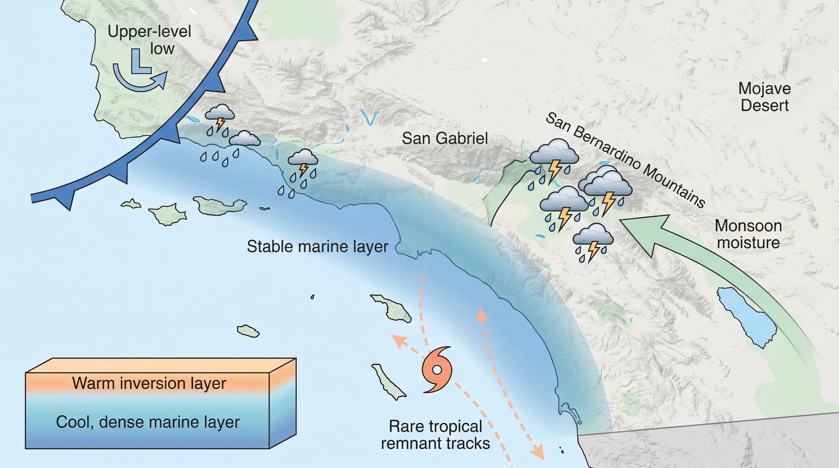
Four separate weather patterns account for nearly all Southern California thunderstorms, and each solves the coast's usual problem, missing instability or missing moisture, in a different way. Cold upper-level low pressure systems and winter cold fronts can destabilize the atmosphere in any season by dragging colder air aloft over the region, occasionally producing enough instability to spark storms even along the coast. Summer monsoon surges, typically running from July through September, pull moisture north from Mexico and the Gulf of California into the mountains and deserts, combining with intense daytime heating over high terrain to build reliable afternoon storms.

Mountain slopes themselves provide a steady source of local lift on ordinary hot days, which is part of why the San Gabriel and San Bernardino Mountains see afternoon storm activity that the flat coastal basin rarely does. Decaying tropical remnants from the eastern Pacific are the rarest source, occasionally dragging enough moisture into the region in late summer or fall to spark storms well outside the usual monsoon pattern.

The practical result is a sharp contrast in frequency across a fairly short distance. Low elevation stations across the LA Basin log only a handful of thunder days in a typical year, while the mountains and deserts see meaningfully more activity, concentrated in the monsoon months. A more detailed breakdown of how often storms actually occur across the region, including specific station data, is covered in thunderstorms and lightning in Los Angeles, and the mountain and desert monsoon pattern itself is covered in more depth in what is the monsoon.

Because heat also shapes how muggy, oppressive afternoons feel even without a storm, what is the heat index explains the related but separate question of why a hot, humid LA afternoon can feel worse than the thermometer suggests, storm or no storm.

A seasonal Southern California map marking winter cold-front and upper-level-low storms reaching the coast, summer monsoon-fueled storms concentrated over the San Gabriel and San Bernardino Mountains and the deserts, and rare late-summer tropical remnant tracks
Southern California thunderstorm sources split by season and geography: cool-season fronts occasionally reach the coast, summer monsoon moisture drives routine mountain and desert storms, and decaying tropical remnants are the rarest contributor.

Pasadena, sitting at the base of the San Gabriels, sees more storm activity drift down from the mountains than flatter basin communities farther from the range, while inland valleys such as Woodland Hills can pick up more instability on hot afternoons than the immediate coast, without reaching the frequency of the high country itself. Elevation and distance from the marine layer both matter, which is why two places 30 miles apart can have very different thunderstorm odds on the same summer day.

What makes a dry thunderstorm different?

A dry thunderstorm produces lightning, thunder, and gusty outflow winds while little or no rain actually reaches the ground. It happens when rain falling out of the storm passes through a deep layer of very dry air beneath the cloud base and evaporates completely before landing, a process called virga. The lightning generated higher in the storm strikes with full intensity regardless of what happens to the rain underneath it, since charge separation occurs well above the dry layer that is evaporating the precipitation.

That combination makes dry thunderstorms a serious wildfire concern in Southern California's mountains and deserts, where summer monsoon storms often form over already parched chaparral and forest fuel. A lightning strike can ignite dry vegetation with essentially no rainfall at the surface to help contain the spread, and the storm's downdraft-driven outflow winds, the same gusty winds that spread out ahead of any mature thunderstorm, can push a new spark into a fast-moving fire within minutes. This is a distinct hazard from the electrical mechanics of an individual strike, which are covered in what causes lightning, and from general strike safety, covered in thunderstorms and lightning in Los Angeles.

How should residents track a developing storm?

Radar alone can understate the risk from a dry thunderstorm, since a storm producing significant lightning may show only light rain echoes if most of its precipitation is evaporating before reaching the ground. Pairing a radar loop with lightning detection data and the written forecast discussion from NWS Los Angeles/Oxnard or NWS San Diego gives a fuller picture than any single data source. Before heading into the mountains or desert on a summer afternoon with monsoon moisture in the forecast, it is worth checking for active watches or warnings from either office.

The simplest and most reliable safety rule does not depend on any app, alert, or radar image at all. Per National Weather Service lightning safety guidance, if you can hear thunder, the lightning threat is already close enough to strike where you are standing. That means shelter should begin at the first rumble, in a substantial building or a hard-topped vehicle, rather than waiting for a phone notification or the first drop of rain, since a dry thunderstorm may never produce rain at your location at all.

The short version holds up under scrutiny: Los Angeles has the ingredients for thunderstorms far more often than it has all three of them at once, and the marine layer is usually the ingredient missing at the coast. Before a summer trip into the San Gabriels or the desert, or any day when a cold front or monsoon surge is in the forecast, check current radar, lightning data, and any active NWS alerts on WeatherEscape's Los Angeles forecast pages, and treat the first sound of thunder as your signal to head for shelter.

Frequently Asked Questions

What three ingredients does a thunderstorm need?

Every thunderstorm needs moisture, instability, and lift present in the same place and at the same time. Moisture supplies the water vapor that condenses into cloud and eventually rain. Instability means the atmosphere lets a rising parcel of air stay warmer, and therefore more buoyant, than the air around it as it climbs, so it keeps accelerating upward instead of stalling out. Lift is the trigger, something that physically pushes air upward far enough for that buoyancy to take over, such as daytime heating over a mountain slope, a cold front, or converging winds. Remove any one of the three and a storm cannot organize, no matter how strong the other two are.

How does a cumulus cloud become a thunderstorm?

A rising air parcel cools as it climbs, and once it cools enough its water vapor condenses into visible cloud droplets, forming the base of a cumulus cloud. If instability keeps the parcel rising, the cloud builds vertically into a cumulus congestus tower. The storm only becomes a true thunderstorm once the top of that tower reaches cold enough layers, typically well below freezing, for ice crystals and graupel to form and collide, separating electrical charge until a lightning discharge occurs. A tall, hard-edged cloud tower by itself is not yet a thunderstorm; it needs that ice-phase charging process to actually produce lightning.

Why are thunderstorms uncommon near coastal Los Angeles?

The cool California Current keeps a shallow, stable marine layer sitting over the Los Angeles coast and basin for most of the year, and that stable layer caps instability even on warm, humid afternoons. Because of it, summer, the season when instability and moisture peak almost everywhere else in the country, is actually one of the most storm-free seasons at the LA coast, since onshore flow rarely lets monsoon moisture reach the immediate coastline. Storms are more common in the cooler months, when passing cold fronts and upper-level low pressure systems can briefly supply the lift and instability the marine layer otherwise suppresses.

When and where are local storms more likely?

Four separate patterns produce most Southern California thunderstorms: cold winter storm systems and upper-level lows that can destabilize the atmosphere in any season, summer monsoon surges from July through September that push moisture north from Mexico into the mountains and deserts, daytime heating over high terrain that builds afternoon storms even without a monsoon surge, and rare decaying tropical remnants in late summer or fall. The San Gabriel and San Bernardino Mountains and the deserts just inland see meaningfully more thunderstorm activity than the coast and basin, largely because they combine strong daytime heating with easier access to monsoon moisture.

What makes a dry thunderstorm different?

A dry thunderstorm produces lightning, thunder, and gusty outflow winds while little or no rain actually reaches the ground. That happens when rain falling from the cloud passes through a deep layer of very dry air below cloud base and evaporates completely, a process meteorologists call virga. The lightning strikes with full intensity regardless, so a dry thunderstorm can ignite dry chaparral or forest fuel with no rainfall at the surface to help contain the resulting fire, and the outflow winds that follow can spread a new spark quickly.

How should residents track a developing storm?

Pair a radar loop with lightning detection data and the written forecast discussion from your local National Weather Service office, since radar alone can miss a storm that is producing lightning but little rain, exactly the dry thunderstorm pattern that matters most for fire risk. Check active watches and warnings before heading into the mountains or desert on a summer afternoon when monsoon moisture is in the forecast. The simplest safety rule holds regardless of any app or alert: if you can hear thunder, the storm is already close enough to strike, so move to a substantial building or hard-topped vehicle immediately rather than waiting for an official warning.

Does a tall, dark cloud always mean a thunderstorm is coming?

No. A tall cumulus congestus tower can look dramatic without ever producing lightning, if it runs out of instability, gets sheared apart by wind, or never reaches the cold layers needed for ice to form and separate charge. Only the appearance of lightning and thunder confirms the cloud has actually become a thunderstorm, which is why radar height alone is not a reliable way to judge severity.

Why does the marine layer suppress thunderstorms specifically?

The marine layer is a shallow, cool, moist layer of ocean air trapped under a temperature inversion, a layer where temperature increases with height instead of decreasing. That inversion acts like a lid, since any parcel trying to rise through it hits warmer air above and loses its buoyancy, which is precisely the instability a thunderstorm needs to keep building. The same inversion that produces LA's persistent low coastal cloud cover is what keeps the coast thunderstorm-poor even in warm, humid weather.

Related Destinations

Live Los Angeles Conditions

Compare temperature, wind, clouds, and comfort across the map.

See which microclimates are clear, cool, windy, smoky, or warming up right now.

Open the Weather Map
Destinations☀️Smog Forecast🌫️Smog Heat Map🔒Privacy Policy📄Terms of Service