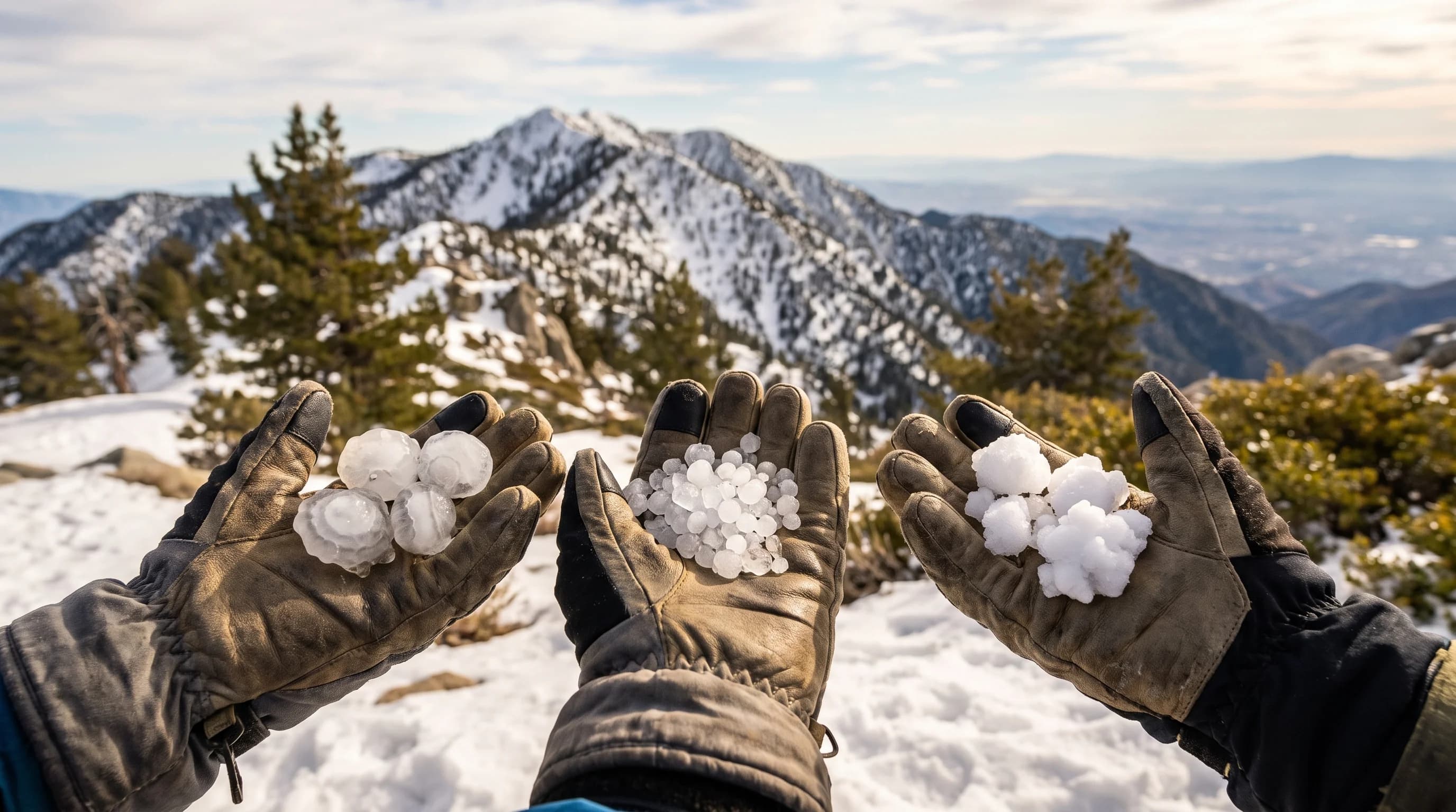
Sleet, hail and graupel are all frozen precipitation, but each forms differently in a storm cloud and lands differently. Sleet is a snowflake that melted and refroze into a small, hard, clear ice pellet.
Hail is a stone built up in repeated trips through a thunderstorm updraft, sometimes with layers like an onion. Graupel is a snow crystal coated in soft, white frozen droplets on the way down. In Southern California's mountains, above Wrightwood and Big Bear Lake, graupel is by far the most common of the three, hail comes with isolated thunderstorms and true sleet is unusual.
What Is the Difference Between Sleet, Hail, and Graupel?
Sleet, hail and graupel are three different forms of ice that form in different ways. Sleet is small, hard, translucent ice pellets, usually under a quarter inch across, that began as snow, melted in a warm layer of air and refroze before landing. Hail is a harder, denser stone that forms only inside thunderstorms, growing in layers as it cycles through a strong updraft, from pea size to larger than golf balls in severe storms. Graupel, also called soft hail or snow pellets, is a soft, crumbly, white pellet formed when a snow crystal collects frozen droplets as it falls through a cloud.
In the United States, "sleet" means ice pellets, and the National Weather Service Los Angeles/Oxnard office uses it that way. In the United Kingdom and some other English-speaking countries, "sleet" usually means rain and wet snow falling together. This article uses the American meaning, which every Southern California forecast uses.
| Feature | Sleet | Hail | Graupel |
|---|---|---|---|
| How it forms | Snow melts aloft, refreezes near the surface | Repeated cycling through a thunderstorm updraft | Supercooled droplets rime onto a falling snow crystal |
| Texture | Hard, clear to translucent | Hard, often layered inside | Soft, opaque, crumbles when squeezed |
| Typical size | Under a quarter inch | Pea size to several inches | Under a quarter inch |
| Storm type | Layered winter storm system | Active thunderstorm with strong updraft | Cold shower or weaker convective cell, no thunder required |
| Season in SoCal | Rare, cold winter storms only | Summer monsoon cells; occasional winter storms | Common in cold-season mountain showers |
| Where in SoCal | Occasional in San Gabriel/San Bernardino high country | Mountains and deserts most often; can reach the basin | Big Bear Lake, Wrightwood, and other high terrain |
How Do Sleet, Hail, and Graupel Form?
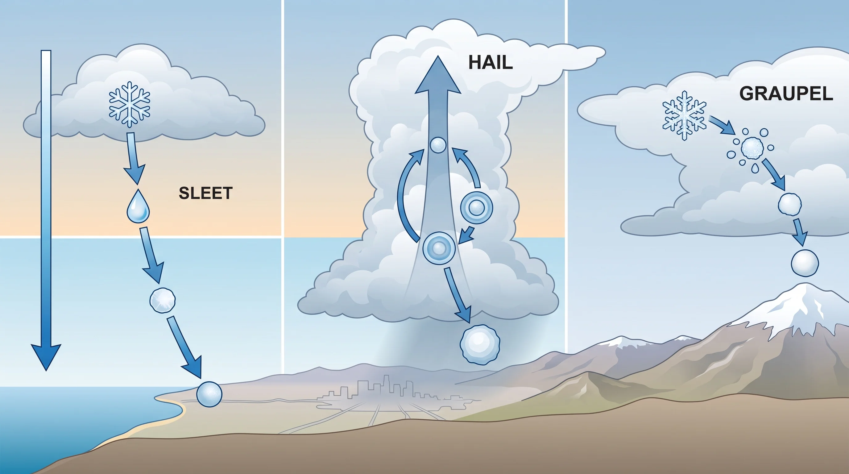
Sleet forms when snow falls into a warm layer and melts, then drops into a freezing layer near the ground that refreezes it into a solid ice pellet. The path through the atmosphere, not the size of the ice, separates sleet, hail and graupel.
Snow forms high in a cold cloud and falls into air above freezing, which melts it partly or completely. The freezing layer below must be deep and cold enough to refreeze the drop. If it is too shallow, the drop reaches the ground as freezing rain instead.
Hail forms only inside thunderstorms with a strong, steady updraft, sometimes tens of miles per hour. The updraft carries a small ice seed up into the part of the cloud full of supercooled water, where it gains a new layer of ice.
Gravity and the storm's air currents send it down and back up, sometimes several times, adding a layer each trip. That is why a hailstone cut in half often shows rings, like an onion or a tree trunk. The stone falls once it is too heavy for the updraft to hold.
Graupel forms in one gentle pass through a process called riming. A snow crystal falls through part of a cloud holding supercooled droplets, water that stays liquid below 32°F until it touches something.
The droplets freeze instantly onto the crystal. Enough of them build up that the crystal's branched shape disappears under a rounded white coating, and the result is graupel. Graupel needs no thunderstorm, only a cold cloud with both snow crystals and supercooled droplets, which is common in mountain snow showers behind a cold front.
How Can You Identify What Is Falling?
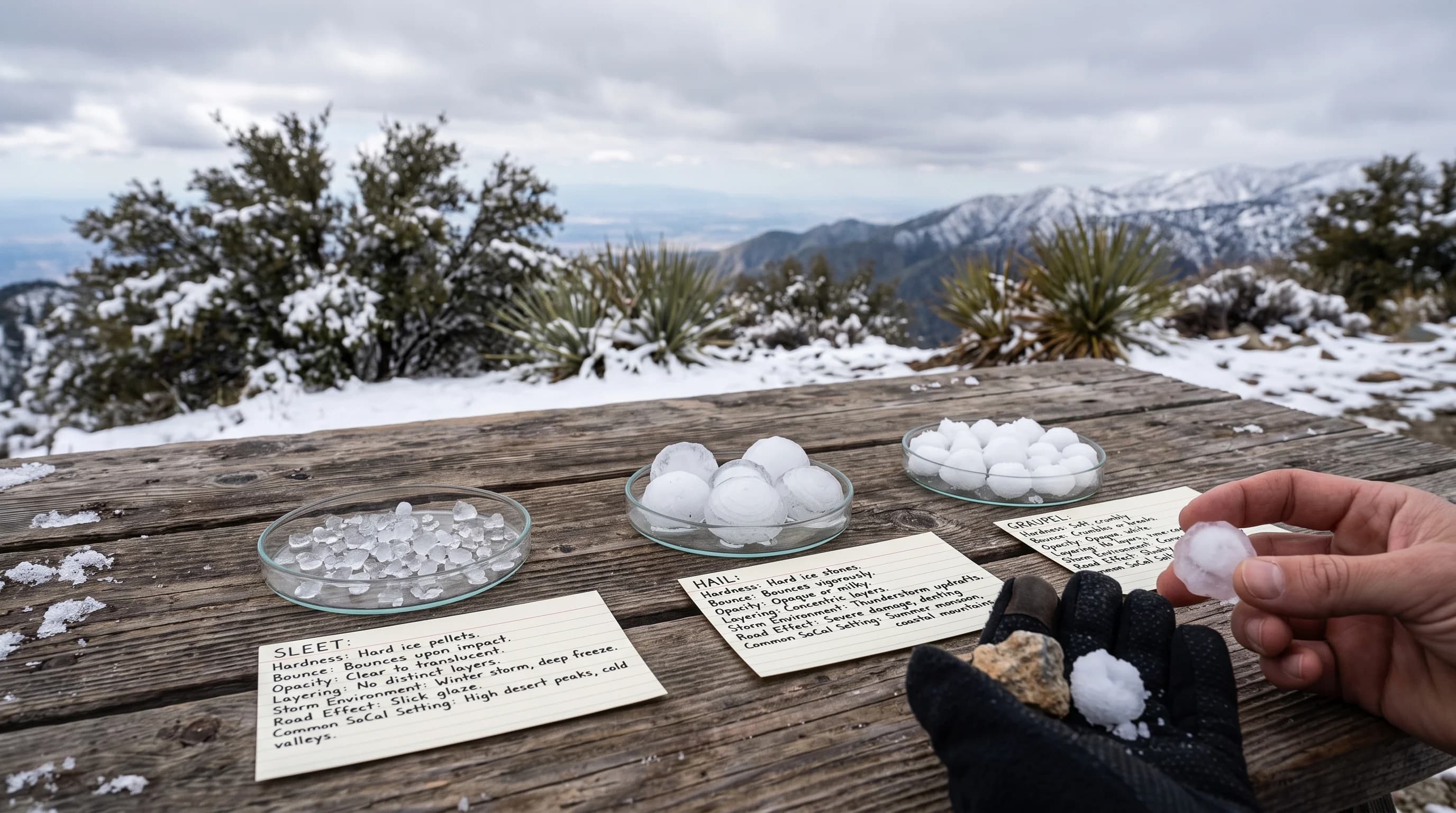
Hardness and sound identify what is falling fastest. Sleet is hard, clear to translucent ice that taps or clicks on a windshield, umbrella or pavement and tends to bounce.
Hail is also hard, usually larger and falls only with an active thunderstorm, so nearby thunder, lightning or heavy downpours confirm it. Graupel is soft enough to crush between two fingers and looks like tiny white foam balls, not clear ice. Graupel often falls from showers with no thunder at all.
Clarity and layers are the next clues, especially in photos or video. Sleet is clear or lightly frosted with no inner bands. Hail, when broken open, often shows onion-like layers from its trips through the updraft, which no other frozen precipitation has.
Graupel is white all the way through, with a rough, grainy surface and no inner structure. Some cases are hard to call: a short burst of small, soft pellets from a fading shower can be hard to identify from a photo. Trained observers often decide by the storm type, elevation and season.
Which Is Most Likely in Southern California?
Graupel is the frozen precipitation Southern Californians see most, especially in the San Gabriel and San Bernardino Mountains during cold showers behind a winter cold front. The region's usual winter pattern, a Pacific front followed by cold, unstable showers, is close to ideal for riming: cold cloud tops with plenty of supercooled water and snow crystals. Mountain towns such as Big Bear Lake and Wrightwood get graupel showers several times in a typical winter, sometimes whitening the ground briefly.
Hail is less frequent but not rare, and it is not limited to winter. The summer monsoon brings isolated, sometimes intense thunderstorms over the mountains and deserts, and any of them can drop small hail. Strong winter storms with enough instability also produce hail. Hail can reach the Los Angeles Basin, including areas near Pasadena and Downtown Los Angeles, though basin hail is brief and limited to one storm's path.
True sleet is the least common of the three in Southern California. Sleet needs warm air aloft to melt a snowflake and cold air near the ground to refreeze it, a layered setup local storms rarely produce. Graupel and small hail are far more common and easy to mistake for sleet from a distance. Check a local sleet report against official NWS confirmation before trusting a single video or photo.
How Are Sleet, Hail, and Graupel Different From Snow and Freezing Rain?
Snow differs from sleet, hail and graupel because it never melts or gains a coating on the way down. Snow keeps its branched crystal shape and falls as light, fluffy flakes, not dense pellets. Sleet is melted and refrozen snow, graupel is snow with a frozen coating and hail forms from scratch in a thunderstorm. For where and how often real snow reaches the region, see WeatherLA's does it snow in Los Angeles guide.
Freezing rain is sleet's opposite on the same temperature profile. Both start as snow that melts in a warm layer aloft. Freezing rain then falls through a cold surface layer too shallow or too mild to refreeze the drop.
The drop stays liquid until it hits a cold road, branch or power line and freezes on contact into a thin, often invisible glaze. Sleet reaches the ground already frozen and piles up as loose, grainy ice instead of a glaze.
Freezing rain is uncommon in Southern California for the same reason sleet is: local storms rarely create the exact shallow freezing layer either needs. For how El Niño and La Niña shift winter storm patterns, see El Niño vs. La Niña: what's the difference for a SoCal winter.
When Do Sleet, Hail, and Graupel Create a Road Hazard?
Sleet, hail and graupel can all make a mountain road dangerous within minutes. Graupel and small hail fall fast enough during a shower or storm to whiten a road in a short burst. Both are round and loose, so they reduce tire grip like marbles scattered across the lane.
Sleet does the same once it piles up, adding a layer of hard, grainy ice that is most dangerous on bridges and overpasses, which cool and ice over first. All three can surprise drivers, because the shower or storm behind them is often brief. A road dry ten minutes earlier can turn slick suddenly.
Frozen precipitation events change quickly and locally, so check current conditions before driving. Use the point forecast and any winter weather or severe thunderstorm alerts from the NWS Los Angeles/Oxnard office or the NWS San Diego office, depending on your route. Confirm chain controls and closures on roads like Angeles Crest Highway and State Route 18 on Caltrans QuickMap. The NWS winter weather safety guidance covers driving on icy mountain roads.
Small white pellets falling in the San Gabriel or San Bernardino Mountains without a thunderstorm are almost always graupel. Pellets with thunder are hail. Sleet is the rarest of the three, so double-check a sleet report with an official source. Before a mountain drive in a cold storm, check the temperature, precipitation type and any alerts on WeatherLA's Los Angeles forecast pages, and confirm road status before heading up to Big Bear Lake or Wrightwood.