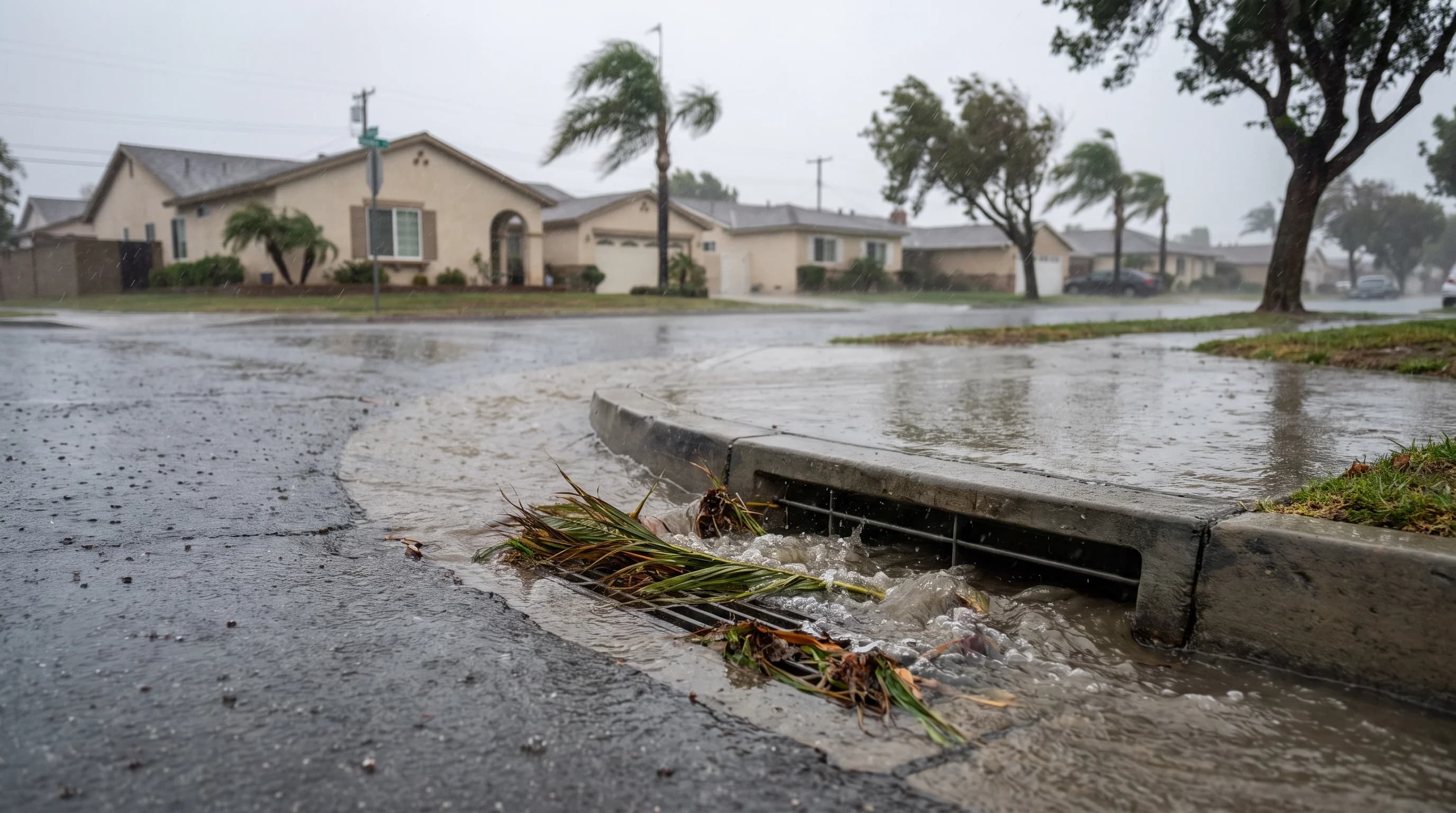
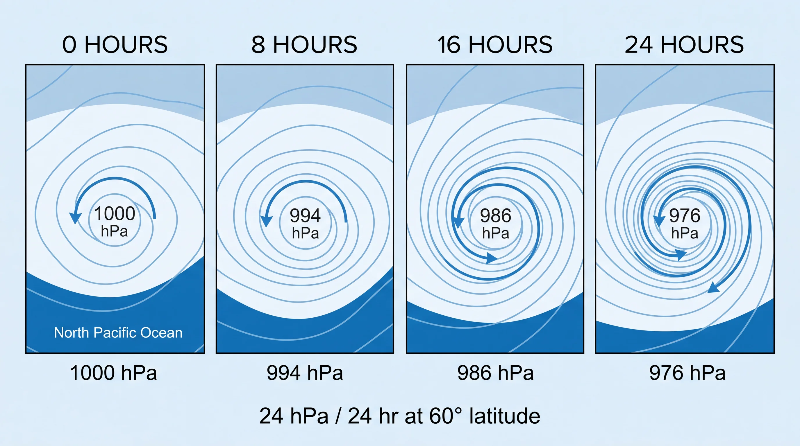
A bomb cyclone is a storm whose central pressure falls at least 24 millibars in 24 hours, adjusted for latitude. Meteorologists call that rapid strengthening bombogenesis.
A bomb cyclone is not a hurricane or a higher storm category. Several Pacific storms reach the threshold every winter far offshore, and only a few bring heavy rain, mountain snow or damaging surf to Southern California. The label measures how fast a storm strengthened, not how much damage it will do in Los Angeles or along the coast.
What Makes a Storm a Bomb Cyclone?
A storm becomes a bomb cyclone when its central pressure drops at least 24 millibars in 24 hours at 60 degrees latitude, a benchmark called the Bergeron criterion. The Coriolis effect that spins storms is weaker toward the equator, so the 24-millibar figure scales with latitude. A storm near California needs a smaller pressure drop to qualify than one near the Gulf of Alaska. The formal term for this rapid strengthening is explosive cyclogenesis.
The bomb cyclone label describes the rate of strengthening only. The label says nothing about whether a storm is tropical, how large it is or how much rain and wind will reach Southern California. The same label can come before a soaking, an offshore miss or a mix of both, depending on the storm's track.
The name comes from explosives because the pressure fall looks dramatic on a weather map, with the cloud shield curling into a tight spiral within a day. A bomb cyclone is still an ordinary mid-latitude low pressure system, the same type behind every winter storm that reaches California. The difference is how fast the storm organizes, not what kind of storm it is.
How Can a Pacific Storm Strengthen So Quickly?
A Pacific storm strengthens quickly when three ingredients line up: a sharp temperature contrast between air masses, strong support from the upper-level jet stream and steady rising air near the storm's center. The contrast is strongest when cold air from the Gulf of Alaska meets warm, moist air over the North Pacific. When a favorable jet stream sits above that boundary, the jet removes air from the top of the storm faster than air flows in at the surface. The pressure at the center then falls quickly.
Rising air also condenses into clouds and releases heat, which lowers surface pressure further and speeds up the cycle. Forecasters watch for this feedback loop when a storm is expected to intensify over open water.
Most bomb cyclones strengthen far offshore in the North Pacific, often thousands of miles from California. The storm center rarely passes over Southern California. The center usually tracks north toward the Pacific Northwest or British Columbia. What reaches Pasadena and the coast is the storm's trailing cold front and the moisture it collected along the way.
How Often Do Bomb Cyclones Affect California?
Storms that meet the bomb cyclone threshold form over the North Pacific several times in a typical winter, according to the National Weather Service Weather Prediction Center. Far fewer bring a major impact to Southern California. Many track north into the Gulf of Alaska or hit the Pacific Northwest and Northern California, leaving Southern California only the weakening tail end.
The number of bomb cyclones that affect Southern California in a given winter depends on that season's storm track. El Niño and La Niña shift the average jet stream position, which changes where the strongest storms aim. A count of bomb cyclones hitting Southern California needs a defined dataset and period. For that, use Weather Prediction Center analyses and NWS event summaries, not headlines, which often call any strong winter storm a bomb cyclone.
What Weather Can Reach Southern California?
A bomb cyclone offshore can bring Southern California heavy rain, mountain snow, high surf and strong wind, and forecasters predict each one separately. Heavy rain is the most common impact, especially when the storm draws in tropical or subtropical moisture and strengthens an atmospheric river aimed at the coast. Mountain snow builds quickly in the San Gabriel and San Bernardino Mountains when cold air follows the front, lowering the snow level at places like Wrightwood and Big Bear Lake.
High surf and rip currents often reach the coast days before the rain, driven by swell from the storm's strong winds offshore. Cold-front gusts reach 40 to 60 mph in exposed coastal and canyon spots, enough to bring down trees and power lines even when rainfall is modest. The storm's track, moisture and timing decide which of these impacts arrive and how strong they are. Whether the storm qualified as a bomb cyclone does not.
| Factor | Typical Pacific storm | Bomb cyclone (bombogenesis) |
|---|---|---|
| Defining threshold | No formal pressure-drop requirement | Central pressure falls at least 24 millibars in 24 hours, latitude-adjusted |
| Formation area | North Pacific storm track, gradual deepening | Often the same North Pacific storm track, but deepening in under a day |
| Storm structure | Broader, less tightly wound low | Tightly curled cloud shield, comma-shaped on satellite |
| Guaranteed local impact | Depends on track and moisture | Still depends entirely on track and moisture; the label alone guarantees nothing |
| What it is not | N/A | Not a hurricane, not an atmospheric river, not a measure of damage |
Is a Bomb Cyclone an Atmospheric River or Hurricane?
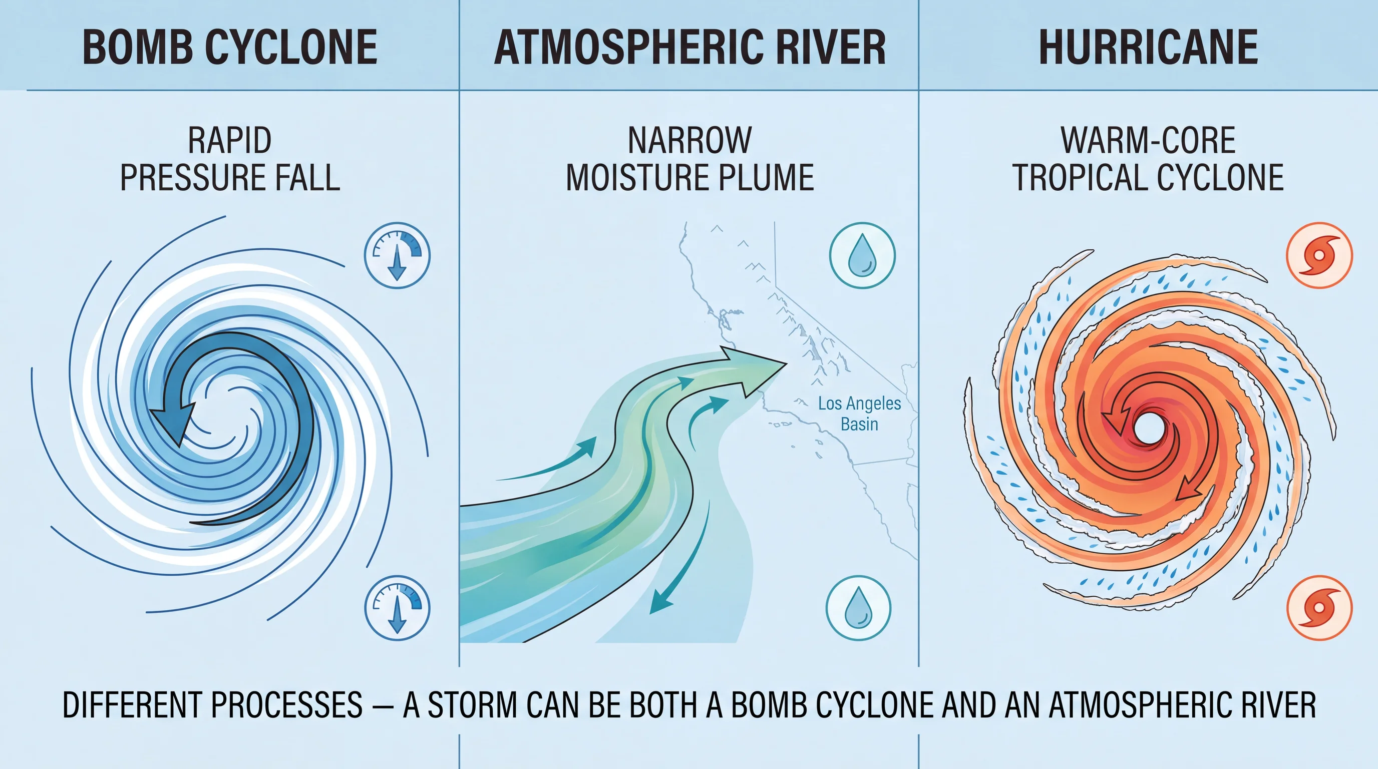
A bomb cyclone is neither an atmospheric river nor a hurricane; the three terms describe different things. A bomb cyclone is a rate of strengthening for a mid-latitude low, the ordinary storm type that brings winter weather to California. An atmospheric river is a long, narrow band of concentrated water vapor moving through the atmosphere, not a storm system itself.
A bomb cyclone can pull an atmospheric river's moisture into its circulation and increase the rainfall at landfall. Atmospheric rivers also reach California often with no bomb cyclone involved, and bomb cyclones can form with little tropical moisture. A hurricane is a warm-core tropical cyclone powered by warm ocean water. A bomb cyclone is a cold-core storm driven by the jet stream.
Pacific storms reaching California are almost never hurricanes, because the cold water off Northern and Central California cannot sustain a tropical cyclone that far north. For how moisture transport works and how strong these events get, see what are atmospheric rivers in Southern California.
How Should Californians Read a Bomb Cyclone Forecast?
To read a bomb cyclone forecast, skip the pressure map and the headline and check the National Weather Service products that drive local decisions. For the Los Angeles Basin, Ventura County and nearby mountains, check NWS Los Angeles/Oxnard for watches, warnings, rainfall totals, snow levels and wind advisories. From Orange County south to the border, check NWS San Diego, since the two offices split forecast responsibility.
A flood watch, high surf advisory or high wind warning for a specific time window tells you more about conditions at Woodland Hills or the coast than the offshore pressure drop does. Those products already account for local track, moisture and terrain. Before any storm that follows a wildfire, also check the NWS flood safety guidance and the USGS landslide hazards program. Intense rain on burned slopes is a separate and serious risk.
For the seasonal pattern of a wet LA winter, see Los Angeles rain and storms: what a wet winter looks like. For the desert side of strong storm systems, see dust storms and desert weather in Southern California.
A bomb cyclone label means a storm organized fast, which makes the storm worth watching. The label is not a forecast for Los Angeles, Long Beach or any other Southern California destination. Before changing plans, compare the NWS rain, wind, surf and snow-level forecasts for your destination on WeatherLA.