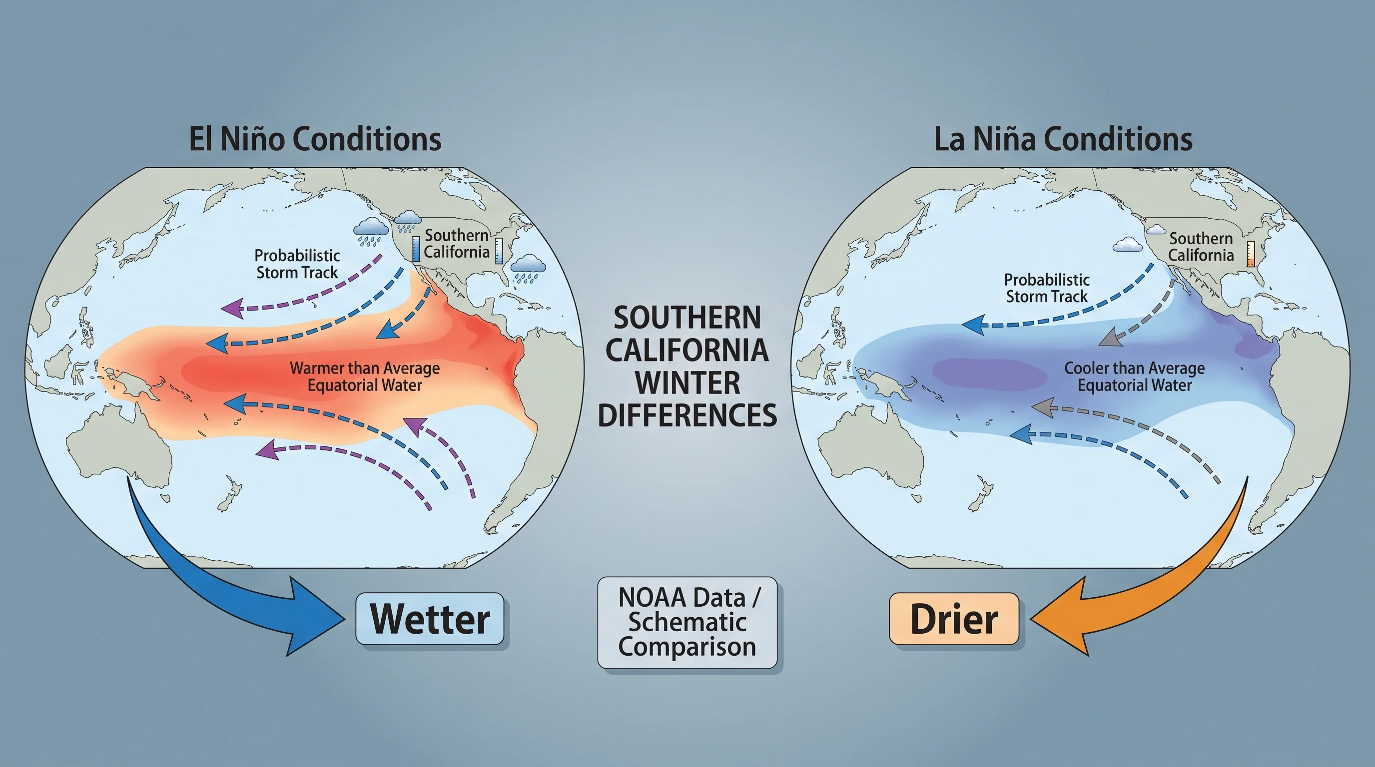
El Niño and La Niña are opposite phases of the same tropical Pacific climate pattern, called ENSO. Both shift the odds of a wet or dry Southern California winter without guaranteeing either. El Niño forms when the central and eastern tropical Pacific is warmer than average, which usually pushes the winter storm track south toward Downtown Los Angeles and the rest of the South Coast.
La Niña is the cool-water phase. La Niña usually steers storms toward the Pacific Northwest and leaves Southern California drier than average. Both patterns are tendencies drawn from decades of past winters, not forecasts for a specific winter. Many El Niño winters have stayed dry, and many La Niña winters have brought a flooding storm.
What Does the Latest El Niño Forecast Mean for LA This Winter?
A wetter-than-normal winter is more likely in Los Angeles in 2026-27. NOAA's September 17 seasonal outlook gives LA a 50-60% chance of above-normal rain for December-February, January-March and February-April. Those chances are unchanged from August. The outlook does not say how much rain LA will get or which weeks will be wet.
El Niño is strengthening, with a greater than 90% chance of a very strong event during fall and winter 2026-27, according to NOAA's September 10 update. That describes the Pacific Ocean pattern. LA's rain still depends on where individual storms go.
For winter temperatures, NOAA gives LA equal chances of above-, near- or below-normal. The next El Niño update is scheduled for October 8, and the next seasonal outlook for October 15. For a specific weekend or commute, check the local forecast as the date approaches.
What Is the Difference Between El Niño and La Niña?
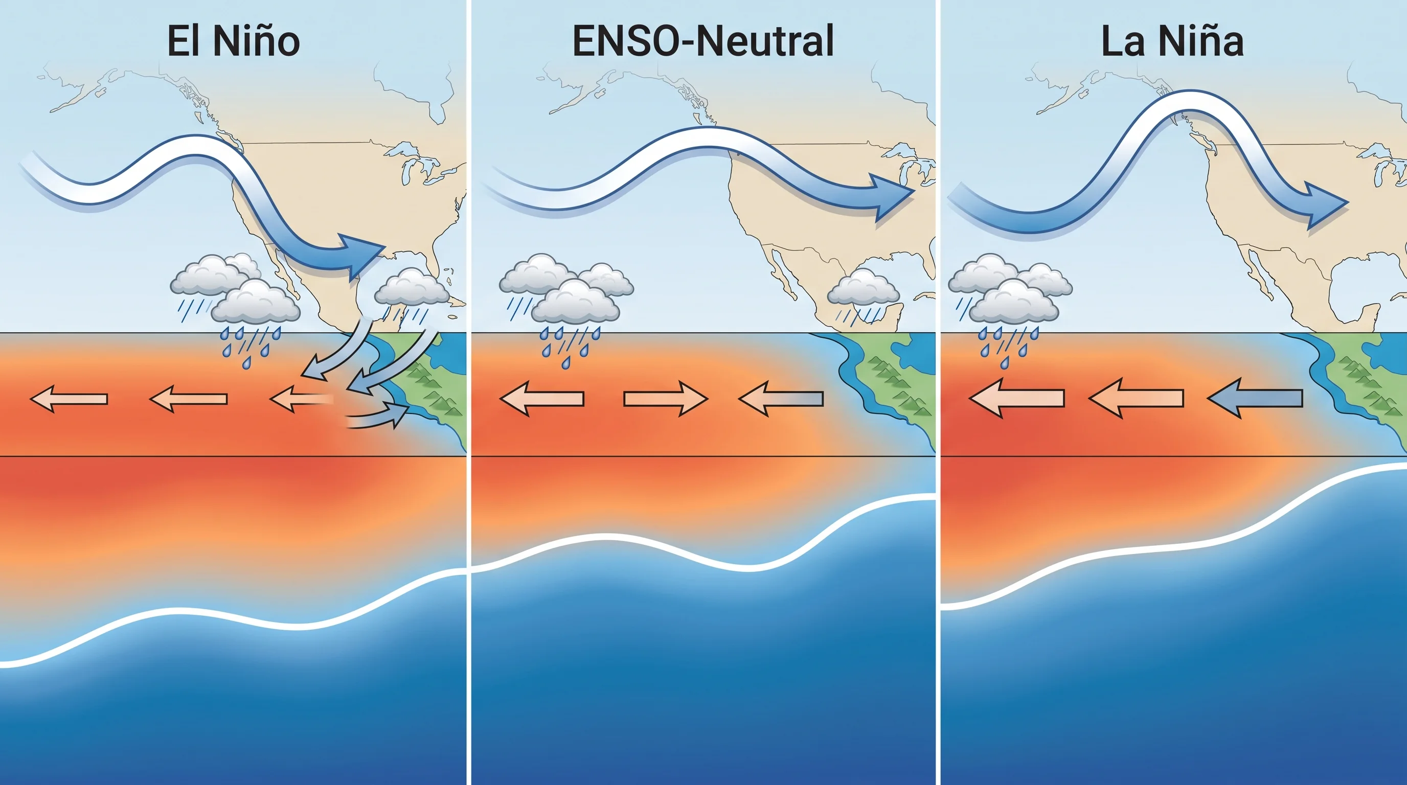
El Niño is the warm phase and La Niña is the cool phase of the El Niño-Southern Oscillation (ENSO), a recurring pattern of ocean temperature and air pressure across the tropical Pacific. During El Niño, the central and eastern tropical Pacific, roughly from the International Date Line to South America, stays warmer than average for at least five overlapping three-month periods. That is the threshold the NOAA Climate Prediction Center uses to declare an episode. During La Niña, the same ocean area stays cooler than average for a similar period, and the easterly trade winds strengthen.
ENSO-neutral is the third state and the most common one. During ENSO-neutral, tropical Pacific temperatures stay close to average, and the winter gets no strong push toward wet or dry. The ocean spends roughly as much time near neutral as in either active phase, according to NOAA Climate.gov. A neutral forecast is a real signal, not missing data.
| Phase | Tropical Pacific ocean signal | Typical winter storm-track tendency | Southern California implication |
|---|---|---|---|
| El Niño | Above-average sea-surface temperatures | Subtropical jet stream tends to strengthen and dip farther south | Above-average odds of a wetter South Coast winter; not a guarantee |
| La Niña | Below-average sea-surface temperatures | Storm track tends to lift north toward the Pacific Northwest | Above-average odds of a drier South Coast winter; not a guarantee |
| ENSO-neutral | Near-average sea-surface temperatures | No consistent tropical Pacific push either direction | Local storm-track variability and other climate patterns dominate the outcome |
How Can the Tropical Pacific Shift the Winter Jet Stream?
The tropical Pacific shifts the winter jet stream by moving where tropical thunderstorms concentrate, which reshapes upper-level winds over North America. Scientists call this long-distance link a teleconnection. During El Niño, warm water moves tropical rainfall and heating east, which strengthens the subtropical jet stream and steers it toward California and the southern United States. During La Niña, heating moves back west, the subtropical jet weakens over California and the polar jet carries more storms into the Pacific Northwest and Northern California.
ENSO shifts the probabilities; it does not fix the jet stream in place. The jet still bends, splits and buckles with day-to-day weather, and a strong storm can reach Southern California in either phase. For the difference between a single storm and a season's tendency, see weather vs. climate: what's the difference in Southern California.
Does El Niño Always Make Southern California Wet?
El Niño does not always make Southern California wet. El Niño raises the odds of an above-average rain season on the South Coast, but El Niño winters have been both dry and historic, depending on storm track and timing.
The strong El Niño winters of 1982-83 and 1997-98 brought exceptionally heavy rain and flooding. Both rank among the wettest seasons in the Downtown Los Angeles rainfall record. The strong 2015-16 El Niño, one of the most intense on record by ocean temperature, brought below-normal rain to much of the South Coast.
The gap between a strong ocean signal and a wet winter comes down to individual atmospheric river storms: whether they form, whether they reach Southern California instead of sliding north and whether they carry enough moisture. El Niño raises the number of chances, especially for subtropical moisture reaching Los Angeles and points south. A single wet January can change a whole season's total, so read seasonal rainfall as a running number through April, not a verdict in November.
Does La Niña Always Make Southern California Dry?
La Niña does not always make Southern California dry. La Niña tilts the odds toward a below-average South Coast rain season, but some La Niña winters have still brought significant storms and local flooding. The La Niña signal is also weaker and less consistent on the South Coast than in Northern California and the Pacific Northwest.
Statewide precipitation figures can mislead Los Angeles residents. A La Niña winter that is very dry in the Sierra Nevada and Northern California can leave the South Coast closer to normal, because the two regions do not always move together. To compare a "California was dry" headline with conditions in Pasadena or the San Gabriel Valley, check a South Coast station total.
How Can Either Phase Affect Rain, Snow, Surf, and Fire Weather?
El Niño and La Niña affect rain, snow, surf and fire weather only as one input among several local weather controls. Mountain snow in the San Gabriel and San Bernardino ranges depends on how many storms arrive, which El Niño can increase, and on each storm's freezing level, which depends on the air mass. A wet El Niño winter is not automatically snowy at resort elevations if its storms are mild. A colder La Niña storm can still bring good mountain snow in a drier season.
Surf follows the storm track. A more southerly El Niño storm track produces larger, more frequent south and southwest swells on Southern California beaches, with more coastal erosion and higher water levels in the strongest storms.
Fire weather follows a delayed, opposite pattern. A wet El Niño winter grows heavy grass and brush that dries into fuel by the next fall. A dry La Niña winter leaves plants stressed before Santa Ana wind season.
Neither El Niño nor La Niña directly causes a specific atmospheric river, Santa Ana wind event or wildfire. Each still needs its own weather pattern on top of the seasonal tendency. For how individual winter storms produce different precipitation types in the local mountains, see sleet vs. hail vs. graupel: what falls on SoCal's mountains.
Which ENSO Outlook Should You Use?
Use the NOAA Climate Prediction Center ENSO outlook, the official source for ENSO status and monthly seasonal outlooks. Each outlook gives the probability of El Niño, La Niña or neutral conditions, with an issue date and a confidence level. An early-fall outlook is less certain than a December update, when more of the winter pattern has formed. NOAA Climate.gov explains the same updates in plain language.
A seasonal ENSO outlook does not replace a short-range forecast before a specific storm. For days-ahead rain and mountain snow forecasts, NWS Los Angeles/Oxnard covers the Los Angeles Basin, Ventura County and the San Gabriel and Santa Monica Mountains. NWS San Diego covers San Diego County, Orange County and most of the Inland Empire. The California Department of Water Resources tracks statewide snowpack and reservoir storage against historical averages all winter.
Use ENSO as context, not as a forecast. Check NOAA's current ENSO status to see which way the winter odds lean. Then check the short-range forecast for Woodland Hills or your location before planning around a specific storm. WeatherLA's Los Angeles forecast pages show the near-term forecast, radar and rainfall totals that decide whether this week is an umbrella day or a beach day.