beach weatherclimate sciencesafetyphenomenasevere weather

Coastal Erosion: Why SoCal Beaches and Cliffs Retreat

By WeatherLA|Published |Last updated |12 min read
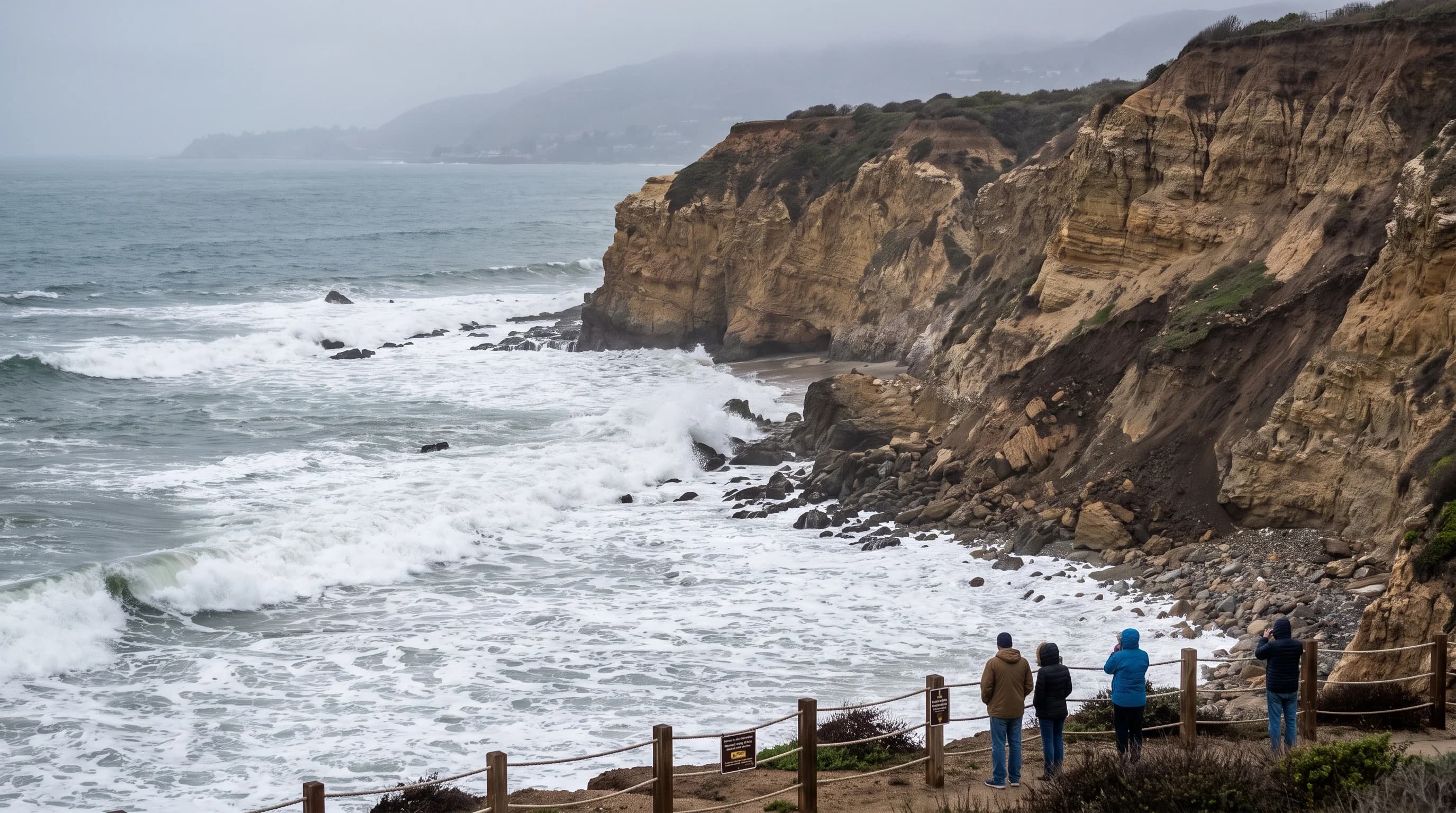
A Southern California pocket beach beneath layered sea cliffs, with a winter-narrowed shoreline, visible toe erosion, and visitors observing from a safe marked setback

Key Takeaways

  • Coastal erosion is the ongoing landward loss of beach, dune, or cliff material, distinct from the normal seasonal narrowing that Southern California beaches show every winter and rebuild every summer.
  • Wave energy drives erosion through swash, undertow, and toe erosion at a cliff base, and a saturated bluff can collapse hours or days after a storm has already passed.
  • Southern California beaches erode unevenly because exposure, shoreline orientation, cliff geology, beach width, submarine canyons, and seawalls all change how much wave energy reaches the shore.
  • Dams, debris basins, armored riverbeds, and harbor jetties have cut off much of the natural sand supply that rivers and eroding bluffs once fed into local littoral cells.
  • Seawalls protect the structures behind them but can starve the beach in front of them and shift erosion downcoast, while beach nourishment is a temporary, repeatable fix rather than a permanent one.
  • Before walking near a Southern California bluff, check posted closures, stay back from both the edge and the base, and confirm the tide and surf forecast for your destination.

Southern California beaches and sea cliffs retreat when waves, storms, sea level, and a shrinking natural sand supply remove more material than the coast can rebuild. It is a constant tug-of-war between erosion and replenishment, and along much of the coast the supply side has lost ground for decades. At Malibu, Palos Verdes Estates, and San Pedro, that imbalance shows up as narrower beaches, undercut bluffs, and closures that catch visitors off guard. None of it is random. It follows physical mechanisms that agencies like the U.S. Geological Survey and the California Coastal Commission have studied and mapped for years.

What Is Coastal Erosion?

Coastal erosion is the progressive landward loss of beach sand, dune material, or cliff rock, measured as a trend over years or decades rather than judged from a single day at the beach. That distinction matters because Southern California beaches already go through a predictable seasonal cycle that looks like erosion but usually is not. Bigger winter waves pull sand offshore and store it in submerged sandbars, leaving a narrower, steeper beach from roughly November through March. Gentler summer waves then push that same sand back onshore, rebuilding the wide, flat beach most visitors picture. A beach that looks thin in February is often just in its winter configuration, not disappearing.

True long-term erosion is what remains after that seasonal swing is subtracted out. It is the reason a beach keeps ending up narrower each summer than it was the summer before, or the reason a cliff face keeps losing the same few feet of setback year after year. Researchers track this with repeat surveys, historical aerial photographs, and beach profile monitoring, comparing the same transect line at the same time of year across multiple seasons. A single storm, however dramatic, is a data point. A documented trend across many storms and many years is what coastal scientists mean when they say a beach or bluff is eroding.

Main Drivers of Southern California Coastal Erosion
DriverMechanismTypical timescale
Everyday wave actionSwash and backwash move sand offshore and along the coast with every tide cycleHours to days, cumulative over a season
Winter storm swellLarge waves concentrate energy at the cliff base and cut a notch through toe erosion; failure can lag the storm by hours or daysSingle events, effects can persist for years
El Niño storm surge and elevated sea levelWarmer coastal water and low pressure raise sea surface elevation, letting normal storm waves reach higher on the beach and bluff than usualEpisodic, tied to El Niño winters
Long-term sea-level riseA rising baseline water level shifts the entire zone where waves can reach inland, independent of any single stormDecades
Cliff and bluff geologyWeakly consolidated marine sediment fails faster than resistant rock once undercut or saturated by rainfallVaries by site, from single storms to slow decades-long retreat

How Do Waves and Storms Remove Sand or Weaken Cliffs?

Waves remove beach sand primarily through swash, the rush of water up the beach face, and backwash, its return to the ocean, which together carry sand grains offshore whenever backwash outpaces the incoming swash. Longshore currents, generated when waves approach the shore at an angle, then move that suspended sand along the coast rather than straight out to sea, feeding it into the drift pattern that defines a given stretch of coastline. Undertow and rip currents can pull sand further offshore during high-energy events, depositing it in sandbars that may or may not migrate back onshore once calmer conditions return.

Cliffs erode through a related but distinct process centered on the base of the bluff. Wave impact repeatedly strikes the same zone at the cliff toe, especially during high tide combined with large swell, cutting a notch into the rock or sediment. Above that notch, unsupported material becomes progressively less stable. Rainfall compounds the problem by saturating the bluff from above, adding weight and reducing the internal friction that holds loose or fractured material together.

This is why a cliff can collapse well after the storm and the high tide that undercut it have already passed: the failure is a delayed consequence of accumulated damage, not necessarily something that happens in sync with the waves hitting it. A calm, sunny afternoon at the base of a Southern California sea cliff is never proof that the rock above is stable.

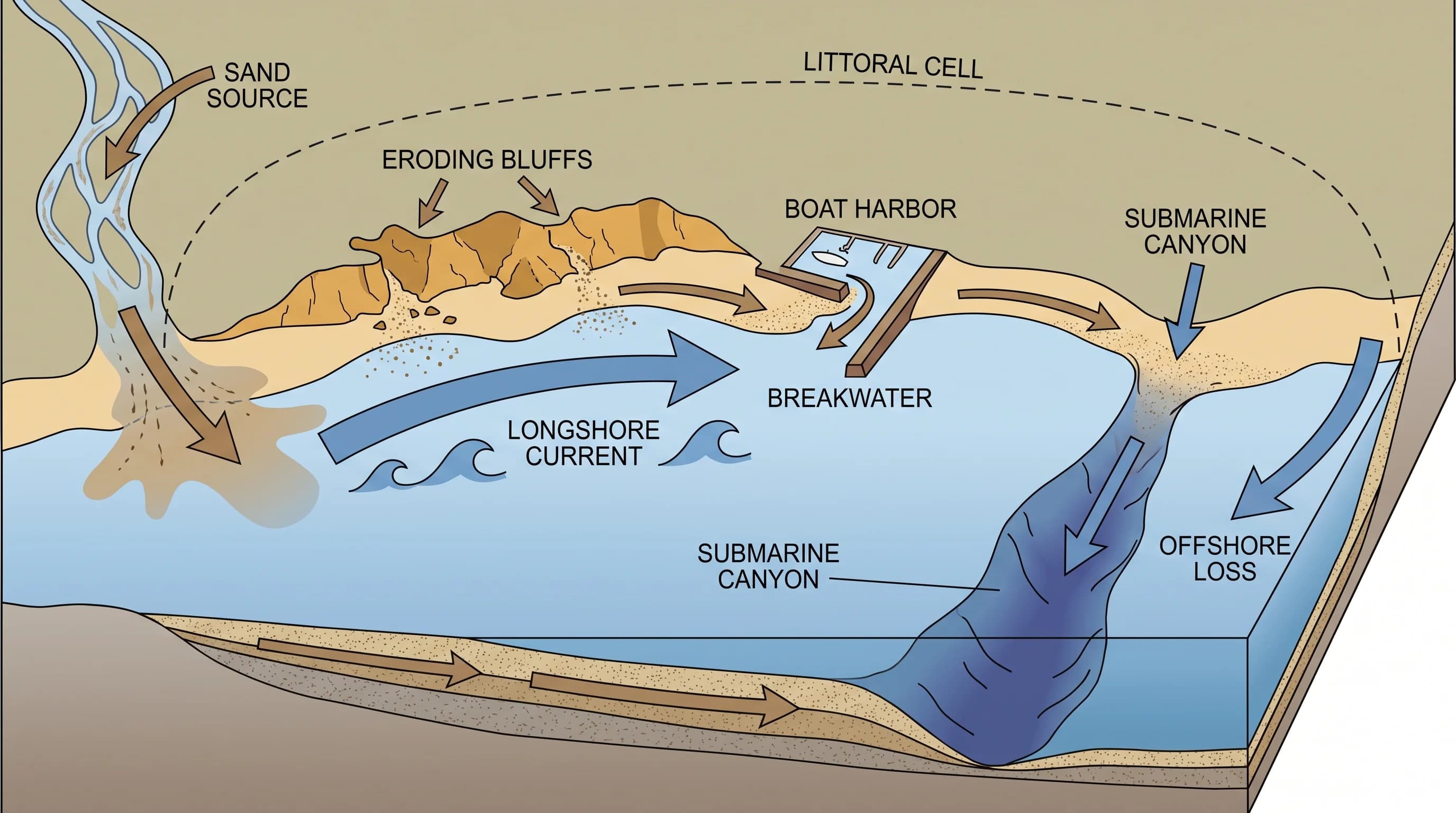
A littoral-cell diagram following sand from river and bluff sources through waves, longshore transport, a harbor, a submarine canyon, and offshore loss
Sand enters a littoral cell from rivers and eroding bluffs, travels along the coast through longshore currents, and eventually exits through a harbor, a submarine canyon, or offshore loss, a cycle that dams and coastal structures can interrupt at any point.

Why Do Southern California Beaches Erode Differently?

Southern California beaches erode at different rates because exposure to incoming swell, shoreline orientation, cliff geology, natural beach width, nearby submarine canyons, and engineered structures each change how much wave energy a given stretch of coast actually absorbs. A beach that faces prevailing west and northwest swell directly takes on more wave energy over a season than a beach tucked into a sheltered cove or pointed away from the dominant swell direction. Wide, gently sloped beaches dissipate wave energy across a longer run-up distance, while narrow beaches backed directly by a bluff offer far less buffer before waves reach the base of the cliff itself.

The orientation of the coastline relative to swell direction is easy to underestimate from the sand. Much of the open Southern California coast faces roughly southwest to west, putting it in the direct path of the long-period northwest swell that dominates the winter wave climate, while pocket beaches tucked behind a headland or inside a cove can sit in a wave shadow that receives only a fraction of that same energy. Two beaches only a short drive apart can therefore experience meaningfully different average wave exposure across a season even though they are subject to the same regional storm systems, which is part of why a visitor comparing beach width or bluff condition between two nearby destinations is not comparing two examples of the same process.

Geology adds another layer of variation. The bluffs above beaches in Palos Verdes Estates and along the Malibu coast are cut into marine terrace deposits and sedimentary formations that vary block by block in how well cemented and resistant they are. A cliff face made of weakly consolidated material erodes measurably faster once undercut than a face cut into more resistant rock nearby, which is one reason two beaches a few miles apart can show very different retreat histories even though they experience broadly similar storms.

Submarine canyons close to shore can also intercept sand that would otherwise continue moving along the coast, acting as a permanent sink rather than a temporary storage zone, while jetties and breakwaters near harbors change how sand accumulates or gets stripped from beaches on either side of the structure. Any specific retreat-rate comparison between named Southern California beaches should be checked against a defined coastal monitoring program rather than assumed from general geography, since site-specific studies are the only reliable way to compare two locations with confidence.

How Have Dams and Development Changed the Sand Supply?

Dams, debris basins, and armored flood-control channels built across Southern California's rivers and creeks have cut off a substantial share of the sediment that once traveled downstream to feed local beaches. Each stretch of coastline functions as part of a littoral cell, a roughly self-contained system in which sand enters from rivers and eroding bluffs, moves along the shore through longshore currents, and eventually exits through a harbor entrance, a submarine canyon, or offshore loss. When a dam or debris basin traps sediment upstream, or when a river channel gets lined with concrete to control flooding, that inland source stops contributing new sand to the cell, even though the beaches downcoast keep losing sand to waves and currents at the same rate as before.

Harbor construction and jetty placement add a second layer of disruption. Structures built to stabilize a harbor entrance or protect a marina can trap sand on the upcoast side while starving beaches immediately downcoast of material they would naturally have received. Coastal development itself, including the seawalls and revetments built to protect homes and roads along eroding bluffs, removes another natural sand source: an eroding, unarmored bluff actually contributes sediment to the beach below it as it retreats, so armoring the bluff to stop that erosion also stops that supply. The combined effect across decades is a coastline where sand keeps leaving beaches through normal wave action but arrives in smaller quantities than it once did, a structural sediment deficit that is distinct from the storm-driven mechanics described above.

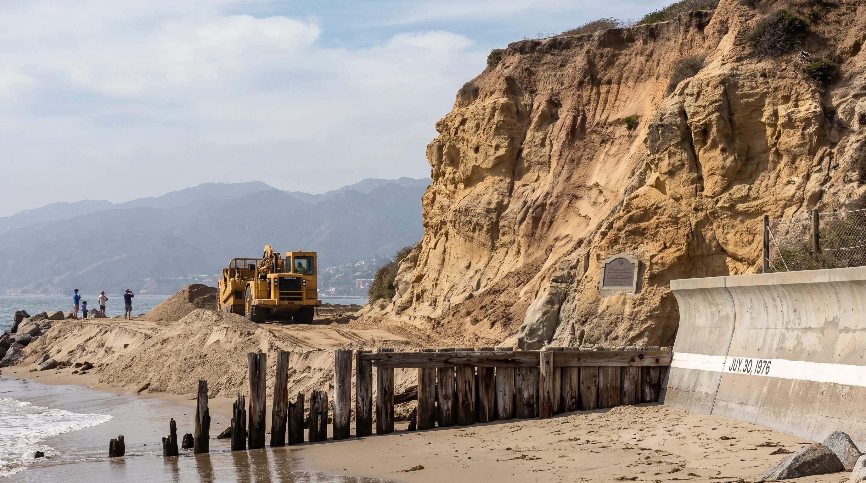
A matched historical and current shoreline profile showing beach nourishment, seawall placement, cliff retreat, sea-level baseline, and measured change dates
Comparing a historical shoreline profile against current conditions, including seawall placement, nourishment sand, and cliff position, is how agencies like USGS and the California Coastal Commission document real long-term retreat rather than normal seasonal beach narrowing.

Can Seawalls or Beach Nourishment Stop Erosion?

Seawalls and revetments protect the specific structures directly behind them, but they do not stop erosion and can make conditions worse for the beach in front of the wall and for the coastline downcoast. A hard wall reflects wave energy rather than absorbing it the way a natural, sloped beach does, and that reflected energy can scour away the remaining sand at the base of the structure over time, sometimes leaving little or no dry beach in front of a wall during high tide even as beaches without walls nearby retain more sand. Because armoring also removes an eroding bluff's natural contribution of sediment to the littoral cell, a wall that protects one property can measurably affect the sand supply reaching beaches down the coast.

Beach nourishment, the practice of trucking in or pumping in new sand to widen a beach, works differently. It restores beach width and storm buffering for a period of years and can support both recreation and dune or bluff protection during that window, but it is a temporary, repeatable intervention rather than a permanent solution. Nourished sand erodes at the same rates driven by wave action, storms, and currents as natural sand, which means a nourishment project has a finite design life and typically needs to be repeated on a set schedule, at real ongoing cost. Neither seawalls nor nourishment addresses the underlying sediment deficit described above; they manage its symptoms at a given location.

For that reason, coastal planners increasingly weigh managed retreat, the deliberate relocation of structures and infrastructure away from an eroding shoreline over time, as one tool among several rather than treating any single approach as a universal fix. Which combination makes sense for a given stretch of coast depends on the specific geology, development pattern, and community priorities in place, which is why the California Coastal Commission evaluates these decisions site by site rather than applying one statewide rule.

How Can Visitors Avoid Unstable Coastal Terrain?

Visitors can avoid the most common coastal erosion hazards by staying well back from both cliff edges and cliff bases, heeding posted closures even when a bluff looks stable, and checking tide and surf conditions before walking below a bluff anywhere along the Southern California coast. A cliff edge can be undercut from below in ways that are not visible from on top, and a cliff base can be struck by waves and dislodged rock with little warning, particularly during and after storms or unusually high tides. Closures posted by state parks, county lifeguards, or local jurisdictions around bluffs at Palos Verdes Estates, Malibu, and other cliff-backed beaches exist because of documented instability, not general caution, and they should be treated as binding rather than optional.

Wildfire history is a less obvious but documented contributor to erosion risk on some Southern California bluffs and the watersheds above them. When fire strips vegetation from slopes and canyons, the following rainy season can produce faster runoff and higher sediment loads reaching the coast in the short term, while also leaving burned hillsides more prone to landslides that can affect coastal bluffs and the roads and trails on top of them. This is a secondary factor compared with wave action, storm timing, and the sediment supply changes described above, but it is one more reason erosion risk at a specific Southern California location can shift from year to year rather than staying constant.

Because erosion hazards compound with tide height and wave energy, it helps to check conditions before a visit rather than judging the beach on arrival. Southern California's king tides push seawater unusually high up the beach and against cliff bases several times a year, and elevated surf described in coverage of high surf in Los Angeles can turn an ordinary beach walk into a hazard even under clear skies. Large, unpredictable waves covered in rogue waves along the SoCal coast are a related but separate risk worth understanding on its own terms.

The NWS beach hazards guidance and current marine forecasts from NWS Los Angeles/Oxnard or NWS San Diego cover the current wave and surf picture, while NOAA Tides and Currents provides the tide predictions and water-level data that determine how much beach is actually exposed at a given hour.

Coastal erosion is not a single event but the long-run outcome of waves, storms, sea level, and a sand supply that Southern California's rivers, harbors, and development have reshaped over the past century. Understanding that mechanism will not tell you whether a specific bluff is safe to stand under today, only a current closure notice, tide table, and surf forecast can do that. Before heading to Malibu, Redondo Beach, or any cliff-backed stretch of the Los Angeles coast, check the current tide, surf, and beach width for your destination on WeatherEscape, and give any posted bluff closure the distance it asks for.

Frequently Asked Questions

What is coastal erosion?

Coastal erosion is the progressive landward movement or loss of beach sand, dune material, or cliff rock over time, as measured against a documented baseline rather than a single visit. A beach that looks narrow after a winter storm is not necessarily eroding in the long-term sense. Many Southern California beaches naturally lose sand in winter, when bigger waves pull it offshore into sandbars, and regain it in summer, when gentler waves push it back onshore. True coastal erosion is the trend that remains after that seasonal cycle is accounted for, typically tracked with repeat surveys over years or decades by agencies like the U.S. Geological Survey and the California Coastal Commission.

How do waves and storms remove sand or weaken cliffs?

Waves remove sand through swash and backwash that carry grains offshore faster than gentler waves return them, and they weaken cliffs by repeatedly striking and undercutting the base, a process called toe erosion. Once a notch is cut into the base of a bluff, the unsupported rock or soil above it can fail well after the storm and high tide that caused it have passed, because rainfall has saturated the cliff material or because gravity simply catches up with an unstable overhang. This lag is why a calm, sunny day at the base of a Southern California sea cliff is not proof that the cliff itself is stable.

Why do Southern California beaches erode differently?

Beaches along the Southern California coast erode at different rates because they differ in wave exposure, shoreline orientation relative to incoming swell, underlying cliff geology, natural beach width, and whether a submarine canyon or engineered structure nearby is redirecting wave energy or trapping sand. A wide, gently sloped beach backed by resistant rock absorbs storm energy differently than a narrow beach backed by loose marine sediment, which is one reason erosion at one Los Angeles County beach does not predict what happens a few miles down the coast.

How have dams and development changed the sand supply?

Dams, flood-control channels, and debris basins built across Southern California rivers and creeks trap sediment that once traveled downstream and replenished beaches, while armored riverbeds and harbor jetties can redirect or block the sand that does reach the coast. Because each stretch of shoreline sits inside a defined littoral cell, a roughly self-contained system that moves sand from inland sources through longshore currents to an eventual submarine canyon or other sink, cutting off an upstream source can reduce the sand supply to beaches far from the dam itself.

Can seawalls or beach nourishment stop erosion?

Seawalls and revetments protect the structures directly behind them but do not stop erosion; they can instead reflect wave energy that scours away the beach in front of the wall and can shift erosion problems to unprotected areas downcoast. Beach nourishment, trucking or pumping in new sand, restores beach width and can support recreation and storm buffering for a period of years, but it is a temporary, repeatable intervention rather than a permanent fix, and each project has a finite design life and cost that agencies weigh against approaches like managed retreat.

How do winter storms and sea-level rise accelerate erosion on Southern California beaches and bluffs?

Winter storms concentrate a disproportionate share of a year's wave energy into a short period, often coinciding with high tides that let waves reach further up a beach or cliff base than they can the rest of the year. Sea-level rise raises the baseline water level those waves are working from, so the same storm reaches higher and farther inland than an equivalent storm decades ago. NOAA Tides and Currents and the NOAA Ocean Service both track the sea-level and storm-tide data that underlie this pattern along the California coast.

Why do some Los Angeles County beaches and bluffs retreat faster than others?

Retreat rates vary because local geology, wave exposure, sand supply, and coastal engineering differ block by block. A bluff cut into weaker, poorly consolidated marine sediment fails more readily than one cut into more resistant rock, a beach downcoast of a harbor or jetty may be starved of sand that the structure is now trapping, and a stretch of coastline directly exposed to prevailing swell absorbs more wave energy than a sheltered cove. Site-specific studies from the California Coastal Commission and USGS coastal change research are the reliable way to compare two specific locations rather than assuming a countywide average applies evenly.

Related Destinations

Live Los Angeles Conditions

Compare temperature, wind, clouds, and comfort across the map.

See which microclimates are clear, cool, windy, smoky, or warming up right now.

Open the Weather Map
Destinations☀️Smog Forecast🌫️Smog Heat Map🔒Privacy Policy📄Terms of Service