safetybeach weatherphenomenaclimate scienceseasonal

High Surf in Los Angeles: When It Turns Deadly

By WeatherLA|Published |Last updated |11 min read
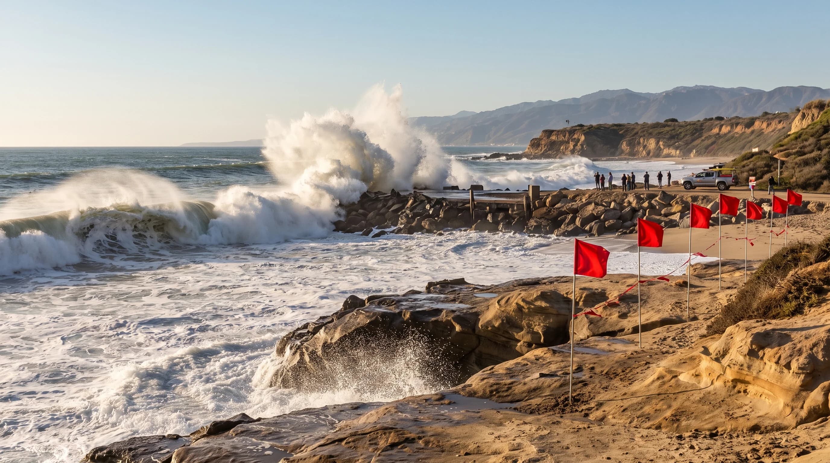
A powerful long-period swell breaking hard along an exposed Los Angeles County beach while lifeguard closure flags keep visitors back from the rocks and jetty

Key Takeaways

  • High surf on Los Angeles County beaches is almost always generated by storms far out in the Pacific or even the Southern Hemisphere, not by local weather, so it can arrive under completely clear LA skies.
  • What matters for safety is wave period and direction as much as raw wave height; a long-period, well-aligned swell breaks with far more force than a short-period wind chop of the same size.
  • Exposure varies sharply by shoreline: south and southwest-facing beaches like those in Malibu, Venice, and the South Bay take the brunt of the biggest swell windows, while harbors and jetty-protected coves stay comparatively calm.
  • The National Weather Service Los Angeles/Oxnard office issues a High Surf Advisory for hazardous but generally survivable-with-caution surf, and a High Surf Warning when breaking waves pose a more serious threat to life and property.
  • High surf and dangerous rip currents usually arrive together, since the same breaking waves that make surf hazardous also push water back out to sea through channels in the sandbar.
  • Coastal flooding from wave run-up can occur during a high surf event even without local rain, especially when a large swell coincides with a high tide, which is why NWS sometimes pairs a High Surf product with a Coastal Flood Advisory.

High surf in Los Angeles happens when energetic ocean swell, usually generated by a storm far out in the Pacific, reaches the coast and breaks with enough force to threaten anyone in or near the water. The danger has little to do with the local sky. A storm spinning 2,000 miles offshore can send clean, powerful waves into Malibu or Santa Monica under full sun, which is exactly why the National Weather Service treats high surf as its own hazard product, separate from the day's weather forecast. Wave period, direction, tide level, and the shape of a specific beach decide how dangerous any given swell actually is.

What Counts as High Surf in Los Angeles?

High surf is officially defined by breaking wave height at the shoreline, not by the height of the swell out in open water. The National Weather Service Los Angeles/Oxnard office (NWS LOX), which covers Los Angeles and Ventura Counties, issues High Surf products when forecast breaking wave faces reach a hazardous range for a given stretch of coast. That range is set locally because the same offshore swell can produce very different breaking surf depending on the beach. A swell that arrives as a clean, moderate wave at a sheltered cove can shoal into a much larger breaking wave at an exposed point a few miles away, so NWS forecasters issue High Surf statements by coastal zone rather than a single countywide number.

It helps to keep two measurements separate. Offshore swell height, the number reported by buoys and surf forecasts, describes the size of the wave in deep water before it reaches shallow ground. Breaking wave face height describes what actually happens at the beach once that swell shoals, steepens, and breaks. A 6-foot offshore swell can produce an 8-to-10-foot breaking face at a beach that focuses wave energy through an underwater canyon or a shallowing point, which is one reason a forecast that sounds moderate offshore can still translate into a genuinely dangerous shoreline.

High Surf Advisory vs. High Surf Warning: NWS Los Angeles/Oxnard Criteria
ProductWhat it signalsTypical hazards to expect
High Surf AdvisoryBreaking waves are forecast to reach a hazardous but lower range for the local coastal zoneStrong rip currents, sneaker waves, dangerous shorebreak, and rocks or jetties becoming hazardous to approach
High Surf WarningBreaking waves are forecast to reach a more dangerous range, a step above Advisory criteria for the same coastal zoneA more serious threat to life and property, including the risk of being swept off rocks, jetties, or beaches, and damage to beachfront structures
Coastal Flood Advisory or WarningIssued separately when wave run-up combined with tide is expected to flood low-lying coastal areasFlooding of beach parking lots, bike paths, and low coastal roads, independent of local rainfall

Exact breaking-wave thresholds for each product are set by the local NWS forecast office and can differ from the criteria used by the NWS San Diego office farther south, so always read the specific product text for the beach in question rather than assume a single number applies statewide.

How Do Distant Storms Send Large Waves to LA County?

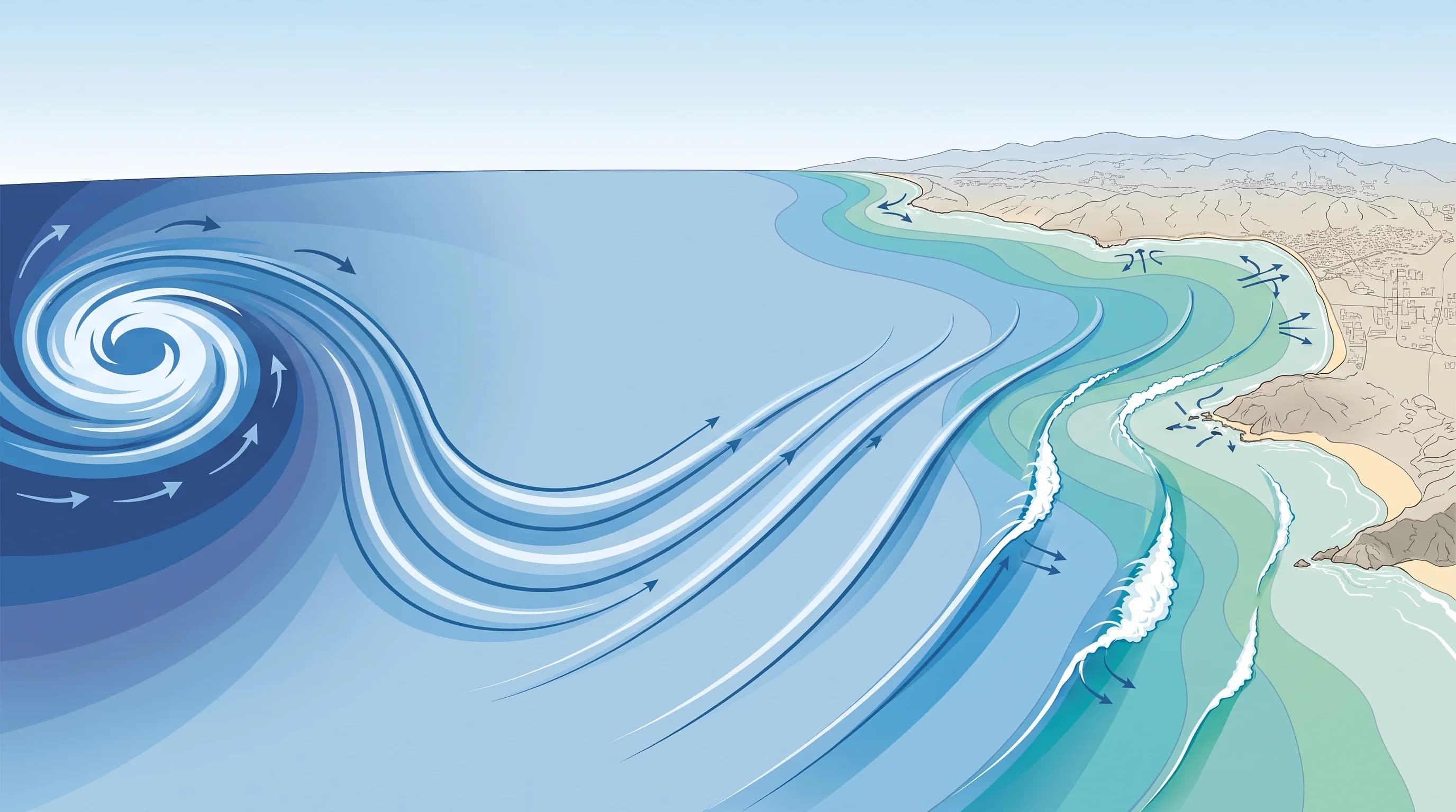
Large waves reach Los Angeles beaches because wind blowing over open ocean for a long distance and a long time organizes into swell, groups of waves that can travel across an entire ocean basin while losing comparatively little energy. Inside a storm, the sea surface is chaotic and choppy. As those waves radiate outward from the storm, the ones with the longest wavelength and longest period, the number of seconds between successive wave crests, travel fastest and separate out from the shorter, choppier waves behind them. By the time swell reaches the Southern California coast, it can arrive as clean, evenly spaced sets, even though the storm that generated it has long since moved on or dissipated entirely.

Wave period matters as much as wave height for how dangerous a swell becomes. A long-period swell, commonly in the 16-to-20-second range or longer for the biggest North Pacific events, carries far more energy per wave than a short-period wind swell of similar height, and it breaks with noticeably more force and a longer reach up the beach. According to NOAA's Ocean Service, as swell moves into shallower water near shore it undergoes shoaling, a process where the wave slows and its height increases as the seafloor rises, and refraction, where the wave bends to align more directly with the contours of the coastline.

Both processes can concentrate wave energy onto specific points, reefs, or beaches and spread it thinner elsewhere, which is a major reason two beaches just a few miles apart can see very different surf from the same offshore swell.

A Pacific swell-travel diagram showing a distant storm's wind field generating organized swell that travels thousands of miles, then shoals, refracts, and breaks as high surf along Los Angeles County beaches
Swell generated by a storm far out in the Pacific can travel thousands of miles with little energy loss, then steepen sharply into dangerous breaking waves as it reaches the shallow water off Los Angeles beaches.

Which Los Angeles Beaches Are Most Exposed?

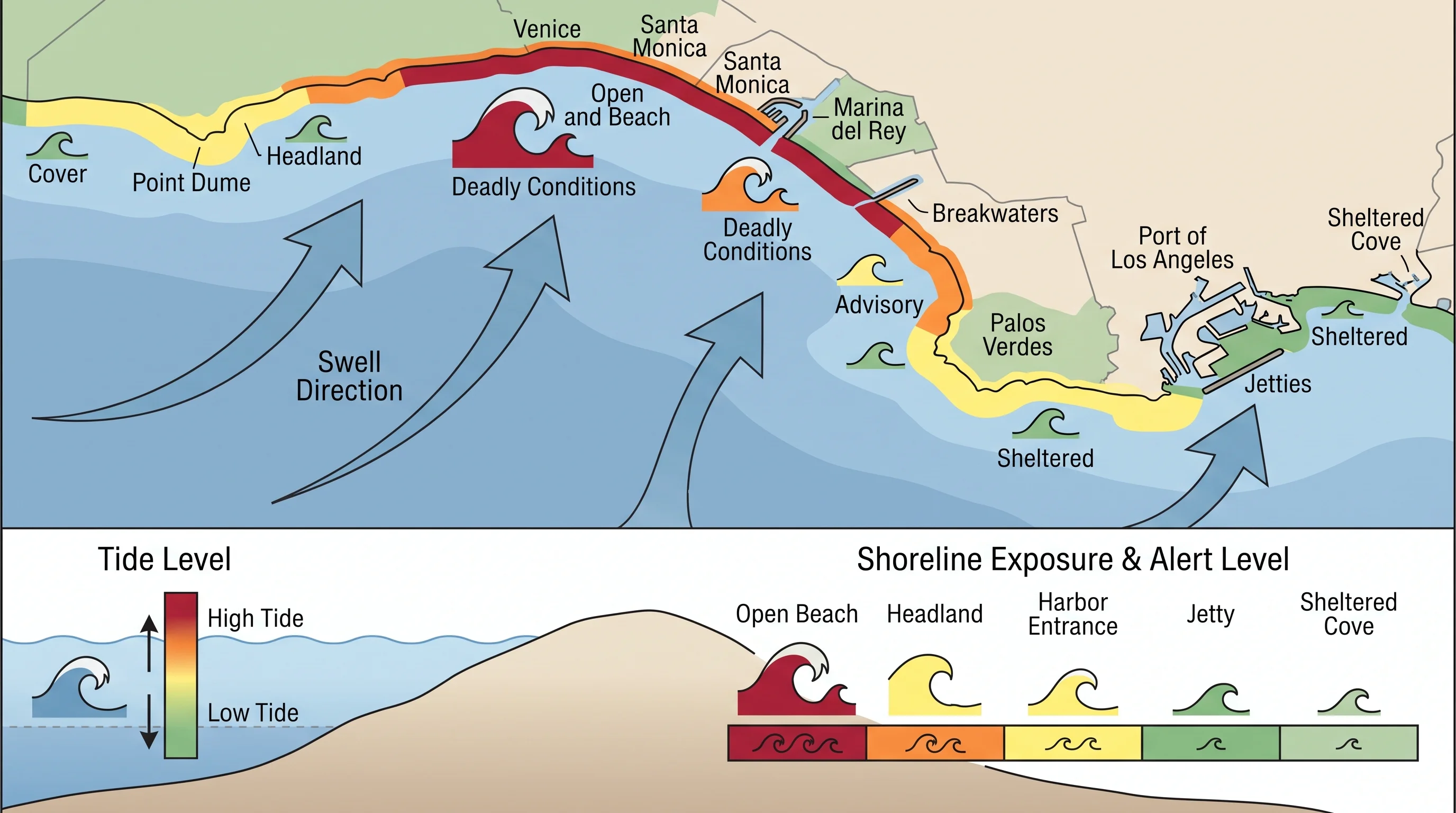
Exposure to any given swell depends on which direction a beach faces, whether a headland, jetty, or breakwater intercepts part of the incoming wave energy, and the shape of the seafloor just offshore. Open, south and southwest-facing stretches of coast, including much of the shoreline around Malibu, Point Dume, and Zuma Beach, tend to catch northwest winter swell and south swell with little to block it. Farther south, the South Bay beaches around Redondo Beach face a broad stretch of open ocean directly and are also frequently exposed.

By contrast, harbors and breakwater-protected areas such as Marina del Rey and the water behind King Harbor in Redondo Beach are shielded from most direct swell by their breakwaters, and coves tucked behind a point or headland can stay comparatively calm even while an open beach a short drive away is closed to swimming.

Jetties, piers, and rock groins deserve specific caution during high surf regardless of which beach they sit on. These structures often calm the water immediately next to them at normal tide, which can look inviting, but a large set wave can wrap around or break directly onto the structure and sweep a person off rocks or a jetty with little warning. This is a general exposure pattern useful for planning, not a fixed ranking of the most dangerous beach in the county. Los Angeles County Fire Department Lifeguards and city lifeguard agencies close specific beaches or sections of beach based on the actual conditions of the day, and that current closure status, not a general reputation, is what should guide a decision to enter the water.

A shoreline-exposure map comparing open Los Angeles County beaches, headlands, harbor entrances, jetties, and sheltered coves by swell direction, tide level, and current alert level
Open, south and southwest-facing beaches typically take the most direct hit from Pacific swell, while breakwater-protected harbors and coves tucked behind a headland stay comparatively sheltered from the same event.

When Is High Surf Most Likely?

Winter is the most active season for high surf in Los Angeles County, driven by strong North Pacific storms that track across the Gulf of Alaska and the central Pacific and send long-period northwest swell down the California coast. These winter events tend to produce the largest and most consistently dangerous surf of the year, often arriving in multi-day windows as one storm system after another moves through the North Pacific storm track. Summer and early fall bring a different pattern: south swell generated by storms far off the coast of New Zealand and Australia in the Southern Hemisphere can travel the length of the Pacific to reach Southern California, and tropical cyclones spinning off the Pacific coast of Mexico can send south to southeast swell northward during hurricane season.

Season is a useful planning guide, not a substitute for the daily forecast. A calm stretch can occur in the middle of winter between storm systems, and a sharp, short-lived swell spike from a well-aligned Southern Hemisphere storm can catch summer beachgoers off guard precisely because high surf feels like a winter-only hazard. The only reliable way to know whether a specific day is dangerous is to check the current NWS surf forecast and any active High Surf product for the coastal zone in question before heading to the beach.

What Is the Difference Between a High Surf Advisory and Warning?

A High Surf Advisory means NWS LOX expects breaking waves to reach a level that is hazardous to anyone in or near the water, generally calling for caution around rip currents, sudden sneaker waves, and rocks or jetties, while ordinary beach activities away from the water's edge remain reasonable with awareness. A High Surf Warning is a step up: NWS LOX expects breaking waves to reach a more dangerous range that poses a more serious threat to life and property, which can include people being swept off beaches, rocks, or jetties, and damage to piers, seawalls, or other coastal structures.

The exact wave-height thresholds that separate an Advisory from a Warning are set locally by the forecast office and are not identical everywhere in California, so the safest habit is to read the specific product text issued for the beach being visited rather than rely on a remembered number.

High surf and coastal flooding are related but separate hazards, and NWS sometimes issues both at once. A High Surf product addresses the danger of breaking waves themselves. A Coastal Flood Advisory or Warning addresses the separate risk that wave run-up, especially when combined with an unusually high astronomical tide, will push water over beaches, parking lots, bike paths, and low coastal roads. Because that flooding mechanism depends on wave energy and tide rather than local rain, it can happen on a completely dry, sunny day, which is part of why coastal flooding surprises visitors who associate flood risk with storms.

How Should Beachgoers Respond?

The most important response to any high surf event is distance from the water's edge, rocks, and jetties, especially during a High Surf Warning. Waves arrive in sets, and a much larger wave can follow several smaller ones with little visible warning, a pattern behind so-called sneaker waves that catch people standing on what looked like dry sand or stable rock moments earlier. Keep a wide setback from jetties, rock groins, and piers during any active High Surf product, since these structures can amplify wave run-up and make it easy to get pinned or swept off by a wave that wraps unexpectedly.

Rip currents are a closely linked hazard during high surf. The volume of water that large breaking waves push onto the beach has to return to the ocean, and it often does so through a narrow, fast-moving channel in the sandbar. The NWS beach hazards guidance recommends never swimming alone, checking for an active Beach Hazards Statement before entering the water, and if caught in a rip current, swimming parallel to shore rather than directly against the current until free of it. Always obey Los Angeles County Fire Department Lifeguards and city lifeguard staff, including posted beach closures, colored warning flags, and verbal instructions, since lifeguards on scene have real-time knowledge of that day's sandbar shape and current conditions that a general forecast cannot capture.

Before heading to the coast during any high surf period, check the current swell height, period, and direction along with the active NWS product for the specific beach, whether that is Venice Beach, Will Rogers State Beach, or the harbor-facing sand near San Pedro. A tide table matters too, since the same swell can produce very different run-up and rip-current behavior at high tide versus low tide. Related hazards worth understanding before a coastal trip include how to spot a rip current on a SoCal beach, what a sneaker wave is and why it catches people off guard, and when king tides raise Southern California's coastal flood risk. Malibu's own shoreline exposure and beach-by-beach planning guidance is covered in high surf in Malibu.

High surf in Los Angeles is a mechanical, forecastable hazard, not a mystery that only strikes during a storm. A swell generated a week earlier and thousands of miles away can turn a calm-looking, sunny beach day into a genuine safety risk within a single tide cycle, and the only way to know which beach and which hours are actually dangerous is to check the current swell forecast, tide table, and active NWS High Surf or Coastal Flood product before getting near the water. Check WeatherEscape's Los Angeles forecast pages for current conditions at your beach, and treat any posted lifeguard closure or warning flag as the final word over any forecast you read the night before.

Frequently Asked Questions

What counts as high surf in Los Angeles?

The National Weather Service Los Angeles/Oxnard office defines high surf using breaking wave face heights that pose a hazard to people on or near the beach, not a single fixed number that applies everywhere. Because breaking wave height depends on shoreline shape, offshore bathymetry, and swell direction, the same offshore swell can produce very different breaking surf at Zuma Beach than at a jetty-protected beach a few miles away, which is why NWS issues High Surf products by coastal zone rather than one countywide number.

How do distant storms send large waves to LA County?

A strong storm generates wind waves that organize into swell as they leave the storm area, and that swell can travel thousands of miles across open ocean while losing relatively little energy, arriving at the Los Angeles coast as clean, powerful waves under a completely clear local sky. Longer-period swell (the seconds between wave crests) carries more energy to the shoreline and breaks with more force than shorter-period wind chop of a similar height, which is why NWS and NOAA forecasters watch swell period and direction as closely as height.

Which Los Angeles beaches are most exposed?

Exposure depends on which direction a beach faces relative to the incoming swell, whether a point, jetty, or breakwater blocks part of the wave energy, and the shape of the seafloor just offshore. South and southwest-facing open beaches, including much of the Malibu and Santa Monica Bay coastline and the South Bay, tend to catch more swell windows directly, while harbors like Marina del Rey and King Harbor and coves tucked behind a point are comparatively sheltered. This is a general exposure pattern, not a fixed ranking, since lifeguards close specific beaches based on the conditions of the day.

When is high surf most likely?

Winter months bring the most frequent and powerful high surf events in Los Angeles County, driven by strong North Pacific storms that track across the Gulf of Alaska and generate long-period northwest swell. Summer and early fall can also bring high surf from Southern Hemisphere storms sending south swell, or from tropical cyclones off the coast of Mexico sending south to southeast swell. Season is a useful planning guide, not a substitute for checking the current NWS forecast, since a calm stretch can occur in winter and a sharp swell spike can occur in summer.

What is the difference between a High Surf Advisory and Warning?

A High Surf Advisory means breaking waves are expected to be hazardous to anyone in or near the water, typically calling for caution around rip currents, sneaker waves, and rocks or jetties. A High Surf Warning means breaking waves are forecast to be more dangerous still, with a more serious threat to life and property, and it typically corresponds to a higher breaking wave range set by the local NWS forecast office. Exact thresholds are set locally and can differ between the NWS Los Angeles/Oxnard office and the NWS San Diego office, so the safest approach is to read the specific product text for the beach in question rather than assume a single statewide number.

How are high surf and rip-current risk connected on Los Angeles beaches?

Large breaking waves push a significant volume of water onto the beach, and that water has to return to the ocean somehow, often through a narrow, fast-moving channel in the sandbar known as a rip current. High surf events are one of the most common triggers for dangerous rip currents on Los Angeles beaches, which is why NWS High Surf products are so often paired with a Beach Hazards Statement covering rip current risk.

Can high surf cause coastal flooding even when it is not raining in Los Angeles?

Yes. Coastal flooding from a high surf event comes from wave run-up and swell pushing water higher onto the shoreline than normal, a mechanism that has nothing to do with local rainfall. When a large swell arrives during an especially high astronomical tide, sometimes called a king tide, wave run-up can reach parking lots, beachfront paths, and low-lying coastal roads even under a sunny sky, which is why NWS sometimes issues a Coastal Flood Advisory alongside a High Surf Advisory or Warning.

Does a bigger offshore swell always mean more dangerous surf?

Not necessarily. Breaking wave height and danger at a specific beach depend on how the offshore swell interacts with local bathymetry, shoreline angle, and tide level, not on the raw offshore height alone. A moderate swell arriving at a beach that focuses wave energy through underwater canyons or points can break larger and more dangerously than a bigger swell hitting a beach that spreads the energy out, which is one reason NWS forecasts describe expected breaking wave faces by coastal zone rather than a single open-ocean buoy reading.

Related Destinations

Live Los Angeles Conditions

Compare temperature, wind, clouds, and comfort across the map.

See which microclimates are clear, cool, windy, smoky, or warming up right now.

Open the Weather Map
Destinations☀️Smog Forecast🌫️Smog Heat Map🔒Privacy Policy📄Terms of Service