safetyrainfallclimate science

Mudslides in LA: Why Hills Give Way After Rain

By WeatherLA|Published |Last updated |6 min read
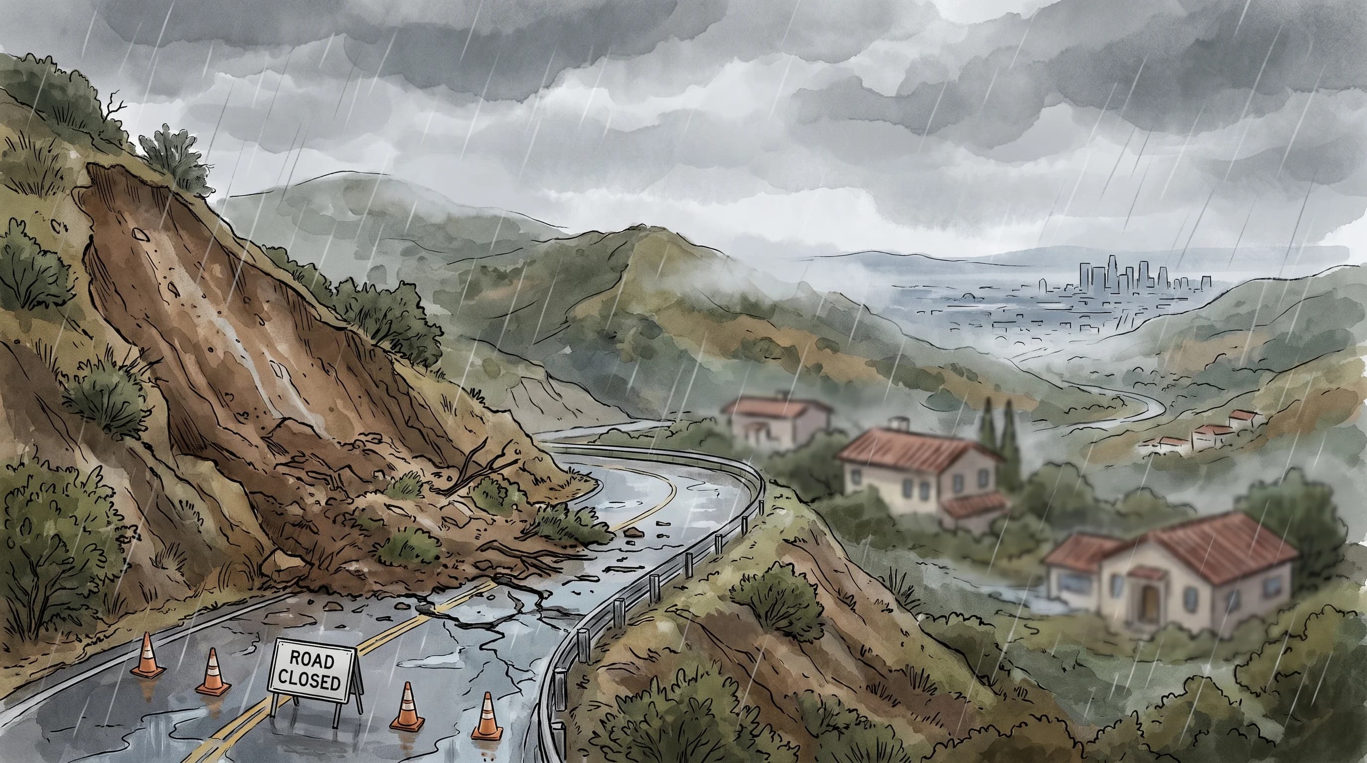
A rain-saturated Los Angeles hillside with a small fresh slump and a closed road below, showing cracks and seepage without a catastrophic collapse

Key Takeaways

  • Rain destabilizes hillsides mainly by raising pore-water pressure between soil particles, reducing the friction that holds a slope together.
  • "Mudslide" is an informal umbrella term; USGS and NWS use more precise labels like landslide, mudflow, and debris flow in official products.
  • Los Angeles hillsides are vulnerable due to overlapping factors: steep terrain, wildfire history, road cuts and grading, and locally weak geology.
  • Warning signs include new cracks, sticking doors and windows, tilting poles or trees, and unusual seepage, though fast debris flows may give little warning.
  • A mudslide is dominated by solid material and tied to slope failure, while a flash flood is dominated by water and can occur on flat ground with no slope at all.
  • Check county landslide hazard maps and active NWS Flood Watches or Warnings, and treat an online checklist as a starting point, not a substitute for professional slope assessment.

Los Angeles hillsides can fail after rain because water raises the pressure between soil particles on a steep slope, weakening the friction that normally holds the ground in place, until gravity wins. This can happen on any sufficiently steep, saturated hillside, not just after a wildfire, though burned slopes, weak bedding layers, and past grading or road cuts all make certain hills more prone to failure than others. "Mudslide" is the term most people reach for, but it covers a range of related hazards that behave differently and call for different responses.

What Do People Mean by a Mudslide?

"Mudslide" is an informal, widely used term rather than a precise scientific classification, and it is often used loosely to describe several related but distinct hazards: a landslide, which is any mass of rock, soil, or debris moving down a slope; a mudflow, a landslide with a high water content that flows rather than slumps; and a debris flow, a fast-moving slurry with a high concentration of solid material, most commonly triggered by intense rain on a recently burned watershed. The U.S. Geological Survey and the National Weather Service use these more precise terms in official products, and this article preserves the official term used for any specific cited event rather than defaulting to "mudslide" throughout.

This page covers the general mechanics of rain-saturated slope failure, on slopes with or without a recent fire history. The specific, faster-moving, and often more dangerous wildfire-driven version of this hazard, where intense short-duration rain on a burned watershed produces a fast debris flow, is covered in full in debris flows: the deadly mud that follows a SoCal wildfire.

How Does Rain Destabilize a Hillside?

Rain destabilizes a hillside primarily by infiltrating the soil and raising what geologists call pore-water pressure, the pressure of water filling the spaces between soil particles. As that pressure rises, it pushes particles apart and reduces the friction that holds them together, which is the same friction that keeps a steep slope standing under normal conditions. Saturated soil also weighs significantly more than dry soil, adding extra downward force on a slope that is already losing some of its internal strength.

What Contributes to Slope Failure After Rain
FactorHow it weakens a slope
Pore-water pressureWater filling soil gaps pushes particles apart, reducing friction
Added weightSaturated soil is heavier, adding downward force on the slope
Weak bedding layersUnderlying rock or soil layers can slide along a lubricated plane
Erosion and undercuttingRunoff removes supporting material at the base of a slope
Slope angleSteeper slopes need less added pressure to reach the failure point

Long-duration soaking rain and short, intense bursts fail hillsides through the same underlying mechanism, saturation, but on different timelines. A slow, steady storm can gradually saturate a deep layer of soil over many hours or days until an ordinary hillside finally gives way, while a short, intense burst is what typically triggers the much faster post-fire debris flows covered separately, since burned, water-repellent soil responds to rainfall intensity rather than total accumulation.

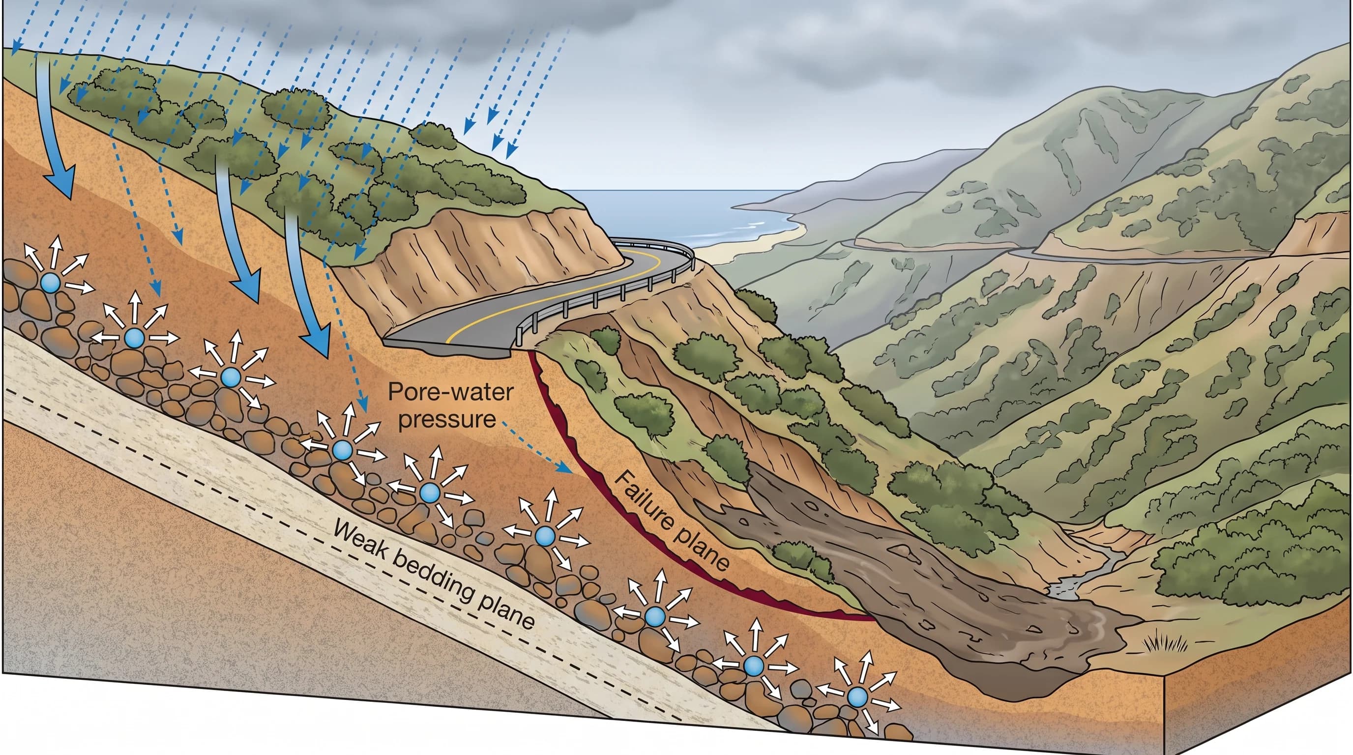
Slope cutaway diagram showing rain infiltrating soil, rising pore-water pressure between particles, a weak bedding layer, a road cut altering drainage, and the resulting slide plane where the hillside gives way
Rain raises pore-water pressure between soil particles, reducing the friction that holds a slope together. Weak bedding layers, road cuts, and erosion can all make a given hillside more prone to failure.

Why Are Los Angeles Hillsides Vulnerable?

Los Angeles hillsides are vulnerable because several risk factors overlap across the region rather than any single cause: steep terrain in the San Gabriel, Santa Monica, and San Bernardino Mountains and their foothills, wildfire history that periodically strips vegetation and alters soil, road cuts and grading from decades of hillside development that can undercut natural slope support, and the underlying geology, which in parts of Southern California includes weak, fractured, or unconsolidated rock layers that are more prone to sliding than solid bedrock.

Not every hillside carries the same risk. A canyon community like Topanga sits in genuinely steep, slide-prone terrain, but that does not mean every coastal bluff or foothill property near Malibu or Santa Clarita carries an identical level of exposure. Slope angle, soil type, drainage history, and recent wildfire all vary block by block, which is why a general regional reputation is a poor substitute for checking the specific hazard information for a given property or route.

What Warning Signs Can Appear?

The USGS Landslide Hazards Program lists several warning signs that can appear before a slower-moving slope failure, including new cracks in the ground, driveways, or foundations, doors and windows that begin sticking or jamming for no obvious reason, tilting utility poles, fences, or trees, unusual water seepage in places that were previously dry, and small rockfall or debris accumulating at the base of a slope. Any of these signs on a hillside property, especially during or after a prolonged rain event, is worth reporting to a county building or geology office rather than waiting to see if the situation develops further.

These warning signs apply mainly to slower, saturation-driven slope failures. A fast, wildfire-driven debris flow can develop and reach a canyon mouth within minutes of an intense rain burst, often with little or no visible warning beforehand, which is why the post-fire debris-flow explainer emphasizes evacuating before triggering rain arrives rather than watching for signs during the storm itself.

How Is a Mudslide Different From a Flash Flood?

A mudslide and a flash flood differ mainly in material and where they occur. A mudslide or landslide is dominated by solid material, saturated soil, rock, and debris, moving down or across a slope, and it is tied specifically to slope failure. A flash flood, by contrast, is dominated by water rather than solid material and does not require a slope at all; it happens whenever rainfall rate exceeds what a channel, storm drain, or paved surface can carry, including in flat urban terrain far from any hillside. The two hazards often occur in the same storm without being the same event, and the water-dominant urban flooding pattern is covered separately in what a wet Los Angeles winter looks like.

Coastal communities show how the water-dominant side of the hazard changes with local terrain: compare the short, paved drainages behind Santa Monica flash flooding with the river and foothill runoff involved in Ventura flash flooding.

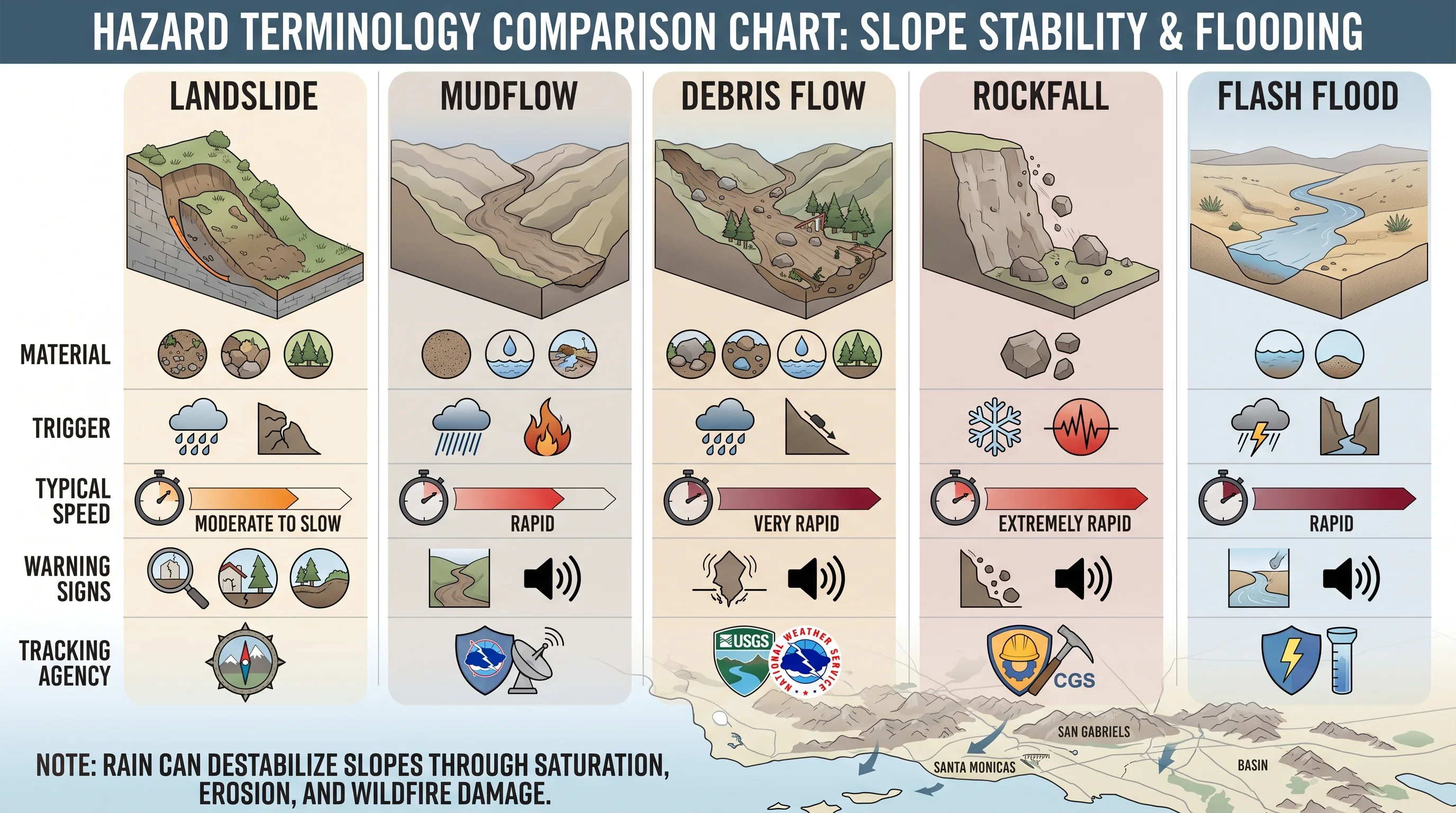
Terminology comparison chart distinguishing landslide, mudflow, debris flow, rockfall, and flash flood by material, trigger, typical speed, warning signs, and the agency responsible for tracking each
Landslide, mudflow, debris flow, rockfall, and flash flood are related but distinct hazards, differing in material, trigger, speed, and which agency tracks each one.

Where Should Residents Get Evacuation Information?

Residents on or below a steep hillside should check county-level landslide and debris-flow hazard maps, sign up for local emergency alerts, and know their evacuation zone before a storm arrives rather than during one. The USGS Landslide Hazards Program maintains hazard assessment resources, and the NWS Los Angeles/Oxnard office and NWS San Diego office issue Flood Watches and Warnings that can accompany prolonged, heavy rain over vulnerable terrain. None of these official products substitute for a professional geotechnical or slope-stability assessment of a specific property; an online checklist can flag concerns worth investigating, but it cannot replace an engineer's evaluation of a hillside's actual condition.

Before a prolonged storm affects a hillside area you care about, check the current rainfall duration and intensity, any active Flood Watch or Warning, and your county's evacuation zone status. WeatherEscape's Los Angeles forecast pages for Pasadena, Woodland Hills, Downtown Los Angeles, and other destinations can help you track incoming rainfall, but the official Watch, Warning, or evacuation order for your specific area, not a general forecast, should always be the final word on whether to leave a hillside area during a serious storm. The terrain-driven variability that shapes hazard exposure across the region is covered in more depth in why Los Angeles has so many microclimates.

Frequently Asked Questions

What do people mean by a mudslide?

Mudslide is an informal term that often covers several related hazards: a landslide, any mass of rock or soil moving down a slope; a mudflow, a landslide with high water content that flows; and a debris flow, a fast-moving slurry with a high concentration of solid material tied to intense rain on burned terrain. Official sources use the more precise term for each specific event.

How does rain destabilize a hillside?

Rain infiltrates soil and raises pore-water pressure, the pressure of water filling gaps between soil particles, which pushes particles apart and reduces the friction holding a slope together. Saturated soil also weighs more, adding downward force, and combined with weak bedding layers or erosion at the base of a slope, this can trigger a failure.

Why are Los Angeles hillsides vulnerable to mudslides?

Several factors overlap in Los Angeles: steep terrain in the surrounding mountains and foothills, periodic wildfire that strips vegetation and alters soil, decades of hillside development including road cuts that can undercut natural slope support, and locally weak or fractured geology in parts of the region.

What warning signs can appear before a mudslide?

The USGS lists new cracks in the ground or foundations, doors and windows that start sticking, tilting utility poles, fences, or trees, unusual water seepage, and small rockfall at the base of a slope. These signs apply mainly to slower slope failures; fast, wildfire-driven debris flows can occur with little visible warning.

How is a mudslide different from a flash flood?

A mudslide is dominated by solid material, saturated soil, rock, and debris, and is tied to slope failure. A flash flood is dominated by water and does not require a slope, happening whenever rainfall exceeds what a channel or storm drain can carry, including on flat urban ground.

Are there mudslides in Malibu?

Malibu includes steep coastal terrain that can be vulnerable to slope failure during prolonged or intense rain, though exposure varies by specific property, slope angle, and drainage history rather than applying uniformly across the area. Checking county hazard maps for a specific location is more reliable than assuming a general risk level.

What caused the mudslides in Montecito, California?

The January 2018 Montecito debris flows, in Santa Barbara County, followed intense short-duration rain on steep terrain recently burned by the Thomas Fire, and are widely cited by emergency managers as a severe example of a fast-moving, highly destructive post-fire debris flow with limited warning time. Readers should consult official USGS and NWS summaries for the full event record.

Related Destinations

Live Los Angeles Conditions

Compare temperature, wind, clouds, and comfort across the map.

See which microclimates are clear, cool, windy, smoky, or warming up right now.

Open the Weather Map
Destinations☀️Smog Forecast🌫️Smog Heat Map🔒Privacy Policy📄Terms of Service