floodingsafetysevere weathercity guide

Why LA Floods Fast: Canyons, Burn Scars, Pavement

By WeatherLA|Published |Last updated |11 min read
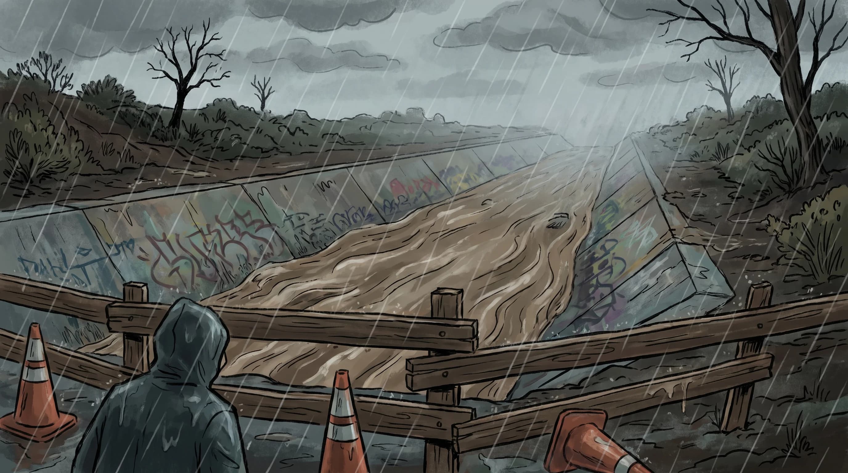
A Los Angeles storm scene showing fast runoff pouring off steep foothills into a concrete flood control channel while a nearby underpass sits closed behind barricades

Key Takeaways

  • Flash flooding in Los Angeles develops when intense rain overwhelms drainage or races off steep, dry, paved, or recently burned terrain faster than people can react, often within an hour of the first heavy cell.
  • The San Gabriel and Santa Monica Mountains rise thousands of feet in just a few miles, so rain that falls on the peaks reaches basin neighborhoods as fast-moving runoff, not a slow soak.
  • No single rainfall total defines a flash flood in LA; the National Weather Service Los Angeles/Oxnard office issues warnings based on rain rate, watershed size, soil saturation, and burn severity together.
  • Recent wildfire burn scars turn ordinary storms into debris-flow hazards because scorched soil cannot absorb water, so the same rain that would soak in normally sheets off as mud and rock.
  • Concrete flood control channels like the Los Angeles River channel look empty and safe between storms but can surge with fast, cold, debris-laden water upstream of where you can see it raining.
  • The Turn Around Don't Drown rule exists because most flood deaths happen in vehicles; six inches of moving water can stall a car and two feet can float it, according to NWS guidance.

Flash flooding hits Los Angeles fast because intense rain falling on steep, often bare or recently burned mountains has almost nowhere to soak in. It runs downhill in minutes, crosses paved neighborhoods that add almost no absorption of their own, and reaches storm drains, concrete channels, and underpasses as a fast-moving pulse rather than a slow rise. The National Weather Service Los Angeles/Oxnard office (NWS LOX) issues Flash Flood Warnings when that combination of rain rate, steep terrain, and saturated or burned soil overwhelms drainage faster than people can react, sometimes in well under an hour from the first heavy cell.

How can Los Angeles go from dry streets to flooding so fast?

The short answer is elevation and distance. The San Gabriel Mountains north of the basin rise above 10,000 feet at Mount San Antonio (Mount Baldy) within about 20 miles of downtown, and the Santa Monica Mountains climb steeply just a few miles from the coast. Rain that falls near those peaks does not have a long, gentle river system to travel through before it reaches the city. It drops down a short, steep watershed, gains speed on the way, and arrives in foothill neighborhoods and basin streets as concentrated runoff within tens of minutes, not hours.

Pavement makes the problem worse once that water reaches the flatlands. Natural soil and vegetation absorb a meaningful share of rainfall and slow the rest down as it moves toward a creek or river. Streets, parking lots, rooftops, and sidewalks absorb essentially none of it, so a storm that would spread out and infiltrate over hours in an undeveloped watershed instead sheets directly into the nearest storm drain or gutter. Engineers built the region's network of concrete flood control channels, including long stretches of the Los Angeles River and San Gabriel River, specifically to move that concentrated urban runoff away from neighborhoods quickly. That same speed is what makes the channels themselves dangerous during a storm, a point covered in more detail below.

Recently burned hillsides remove the last buffer. Wildfire strips vegetation and can bake the top layer of soil into a water-repellent crust, so rain that would normally infiltrate instead runs off almost immediately, carrying ash, mud, and rock with it. The USGS Landslide Hazards Program tracks this post-fire debris-flow risk because it can turn a moderate rainstorm into a life-threatening event on terrain that would have handled the same rain safely before the fire.

Same Storm, Different Flood Risk: How LA Terrain Changes the Hazard
Terrain typeWhat happens to rainfallPrimary hazard
Unburned mountain watershedPartially absorbed; remainder concentrates fast in steep canyonsFast-rising canyon and creek flow
Recent wildfire burn scarRepelled by scorched, water-resistant soil; runs off almost immediatelyDebris flows carrying mud, ash, and rock
Paved urban neighborhoodAlmost no absorption; sheets directly to storm drainsStreet and intersection ponding, storm drain overload
Concrete flood control channelCollects runoff from the entire upstream watershed above itFast, deep, cold water with little warning at your location
Low urban intersection or underpassSits below surrounding grade; drains lastRapid pooling, trapped and stalled vehicles
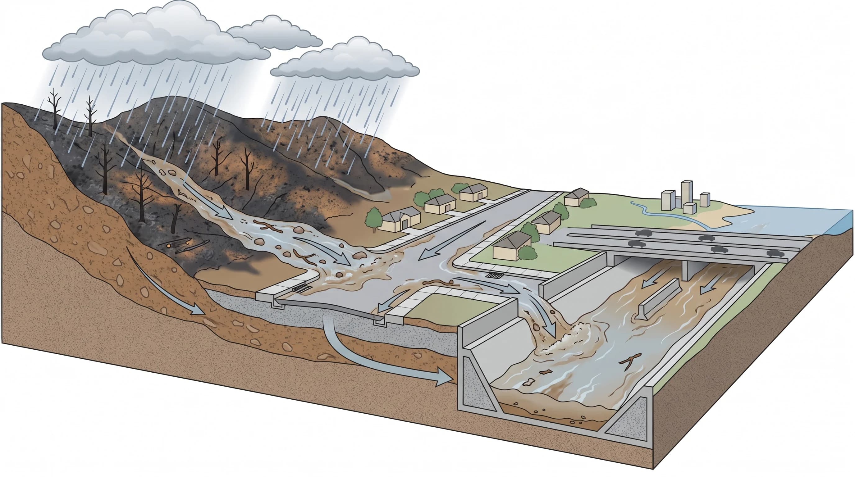
Cutaway illustration of a Los Angeles watershed showing rain on a burned mountain slope running off as debris-laden water, crossing paved streets with almost no absorption, and collecting in a concrete flood control channel before reaching a low freeway underpass
The same rainfall behaves differently at every stage of a Los Angeles watershed, from a burned mountain slope to a paved street to a concrete flood control channel, which is why flash flooding can arrive in one neighborhood well before residents nearby even notice rain.

Which LA landscapes create different flood problems?

Los Angeles County is not one flood risk, it is several, layered across very different terrain within a short drive of each other. Canyon roads that climb into the San Gabriel or Santa Monica Mountains, including routes through areas like Woodland Hills, funnel runoff from a single steep drainage onto a narrow road with few places to turn around once water starts crossing it. A storm that looks minor at the bottom of the canyon can be intense a few miles up the same drainage, and the water from that upper storm arrives at the bottom before the rain does.

The coastal edge has its own versions of the same fast-runoff problem. Flash flooding in Santa Monica is shaped by paved neighborhoods meeting the Santa Monica Mountains, while flash flooding in Ventura adds larger river watersheds and runoff arriving from steep terrain well inland.

Recent wildfire burn scars create the sharpest, most dangerous version of this problem because the ground itself has changed. A rainfall rate that would be unremarkable on healthy chaparral can trigger a debris flow on a slope burned within the last one to five years, and county officials and the NWS treat these burn areas with tighter, lower thresholds for warnings than surrounding unburned terrain. This overlap between ordinary heavy rain and post-fire debris-flow risk is significant enough that it gets its own explanation later in this article, and a full treatment of debris-flow mechanics, warning thresholds, and evacuation zones.

Engineered concrete channels, the Los Angeles River, San Gabriel River, Ballona Creek, and their many tributaries, are built to carry stormwater away from neighborhoods quickly and usually succeed. Their danger is upstream distance: a channel segment near Downtown Los Angeles can surge because of rain falling in the San Gabriel foothills many miles away, well before anyone standing at that downtown segment sees a drop fall.

Underpasses and low urban intersections are a fourth category and arguably the most common one drivers encounter. These points sit below the surrounding street grade by design or by historical accident, so they are always the last places to drain and the first to pond during even a routine storm, let alone an intense one. Cities across the county, including Pasadena, post permanent flood-prone underpass warnings for exactly this reason, and Caltrans and city public works crews close the worst offenders proactively once rain rates climb.

How much rain is enough to trigger a flash flood?

There is no single rainfall total that defines a Los Angeles flash flood, and any claim that a fixed number of inches always triggers one is oversimplified. The NWS Los Angeles/Oxnard office and the Weather Prediction Center base warnings on rainfall rate, meaning how much rain falls in a short window such as 15 or 60 minutes, rather than the storm's total accumulation. A slow-moving storm that drops two inches over eight hours behaves completely differently than a thunderstorm cell that drops an inch in 20 minutes, even though the second event produced less total rain.

Watershed size and shape change the equation too. A small, steep canyon watershed responds to intense rain in minutes, while a larger drainage basin takes longer to concentrate flow but can sustain higher water for longer once it does. Soil saturation from earlier storms in the same week lowers the rain rate needed to cause flooding, since already-wet ground absorbs less of the next round. And burn severity overrides all of it on a fresh scar: the NWS and county flood-control agencies use specifically lowered thresholds for recently burned watersheds because scorched soil can produce debris flows in storms that would be routine anywhere else.

This is why the NWS issues Flash Flood Warnings as a real-time judgment built from radar rainfall estimates, gauge data, and burn-scar overlays rather than from a lookup table. Readers who want the exact difference between the broader watch-and-warning products and the burn-scar specific debris-flow alerts can see flood vs. flash flood for how the terminology and lead time differ.

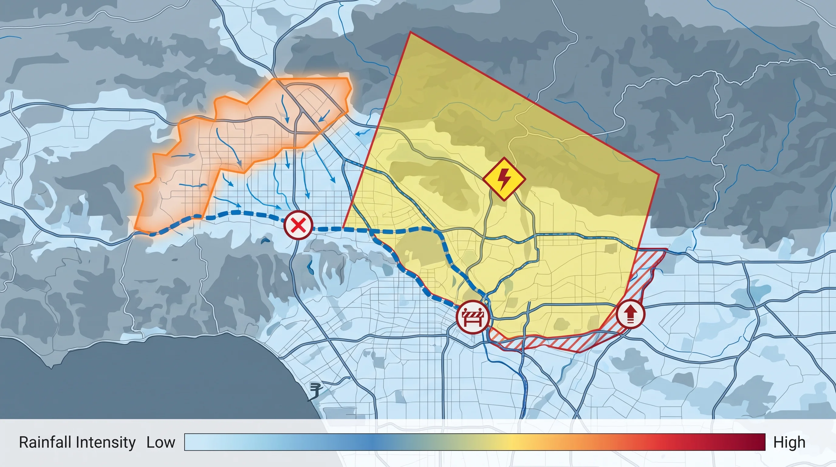
Route-planning graphic layering rainfall rate over a Los Angeles-area map with a burn perimeter outline, a Flash Flood Warning polygon, a closed flood control channel access point, a barricaded underpass, and an evacuation zone boundary
Before traveling in heavy Los Angeles rain, the useful picture combines several live layers at once: rainfall rate, burn perimeter, the active Flash Flood Warning polygon, and any channel, underpass, or evacuation closures along your specific route.

Are concrete channels safe storm viewpoints?

No, and this is one of the most persistent misunderstandings about Los Angeles storms. Flood control channels look calm, wide, and mostly empty between storms, which makes them seem like a safe place to stand and watch a storm pass. In reality they collect runoff from an entire upstream watershed, so a channel can rise from a trickle to a fast, deep flow in minutes because of rain falling miles away in the foothills, with no local rain at the viewing point at all.

Their engineered shape compounds the danger. Most Los Angeles-area flood control channels have smooth, steep concrete sides built to move water efficiently, not to offer footholds or easy exit points once someone or something is in the current. Water moving through a confined concrete channel also tends to be faster and colder than water in a natural creek, and it commonly carries debris, branches, trash, and after a fire, ash and mud, that is not visible from the bank until it is already close.

The practical rule from the NWS is simple: stay out of flood control channels entirely during and after significant rain, regardless of how the water looks from where you are standing, and keep children and pets away from channel fencing and access gates. The same caution applies to storm drains, culverts, and desert washes, which share the same upstream surprise problem even though they look different from a concrete channel.

How do post-fire debris flows change the warning?

A recent wildfire burn scar lowers the rainfall rate needed to trigger a hazardous event and changes what comes down the slope. Because scorched soil sheds water instead of absorbing it, a burned watershed can produce a fast-moving slurry of mud, rock, and burned vegetation, a debris flow, in a storm that would only cause routine runoff on unburned terrain nearby. The National Weather Service and the USGS Landslide Hazards Program coordinate on this risk because it blends two hazards into one warning: the Flash Flood Warning product covers the water and debris-flow threat together for a burn area, since the same intense rain cell usually triggers both at once.

This means a Flash Flood Warning issued for a burn-scar area should be read as more urgent than the same warning issued for unburned terrain, even though the product name is identical. Local emergency management agencies typically layer additional evacuation orders or warnings on top of the NWS product for the highest-risk burn scars, particularly in the first one to two rainy seasons after a fire, when the water-repellent soil layer and lack of recovering vegetation are at their worst. Material thresholds, specific evacuation zone boundaries, and how long a burn scar stays elevated risk are detailed further on WeatherEscape's dedicated debris-flow coverage, since those specifics vary by fire, slope, and rainy season rather than following one countywide rule.

For residents near any burn scar, the practical takeaway is to treat a Flash Flood Warning as an immediate evacuation cue if local officials have designated the area high risk, rather than waiting to see how hard it is raining outside. Debris flows can arrive in minutes once triggered, which is faster than most people can safely evacuate if they wait for visible confirmation.

What should Angelenos check before driving?

Check four things together before driving anywhere in Los Angeles during heavy rain: the active NWS warning polygon for your route, any burn-scar or debris-flow language attached to it, city and county road closures, and the low points on your specific path. A route that looks fine on a map can cross a canyon road, an underpass, or a channel-adjacent street that floods well before nearby streets do, so checking the general forecast for your city is not the same as checking your actual route.

Start with the NWS Los Angeles/Oxnard office for most of the county and the NWS San Diego office for areas near the Orange County line, both of which post active Flash Flood Warnings with polygon maps showing exactly which neighborhoods are covered at a given time. Cross-check that against city and county public works closure lists for any underpasses, canyon roads, or channel-adjacent streets on your route, and against Caltrans for state highways and freeway ramps.

The single rule that matters most once you are behind the wheel is the one the NWS repeats every storm season through its flood safety guidance: never drive through a flooded roadway, no matter how familiar the street or how shallow the water appears. Roughly six inches of moving water can stall a passenger car, and about two feet can float most vehicles, including trucks and SUVs, off the pavement entirely. Depth and current speed are both nearly impossible to judge accurately from a driver's seat, especially at night or in heavy rain, which is exactly why "Turn Around Don't Drown" is a rule, not a suggestion.

Los Angeles's flash-flood risk is not evenly spread across the county, and the mechanism described here plays out differently in Long Beach, Orange County, and desert-adjacent areas like Palm Springs, where washes, valley drainage, and monsoon timing each add their own local pattern on top of the same basic physics. Before you travel through any of them in heavy rain, check WeatherEscape's current conditions and radar for the destination on your route, confirm the active NWS warning polygon and any burn-scar language, and verify road and channel closures directly with the city or county rather than assuming last week's conditions still apply.

Frequently Asked Questions

How can Los Angeles go from dry streets to flooding so fast?

Intense rain falling on the steep, often bare slopes of the San Gabriel, San Bernardino, and Santa Monica Mountains has almost nowhere to soak in, so it runs downhill in minutes and reaches paved neighborhoods, storm drains, and flood control channels as a fast-moving pulse rather than a gradual rise. Because the elevation drop from mountain crest to basin floor happens over just a few miles, the lag between a downpour in the foothills and rising water in a low-lying street or underpass can be well under an hour.

Which LA landscapes create different flood problems?

Canyon roads flood from fast runoff funneling down a single drainage with few escape routes, burn scars turn rain into debris and mud flows because scorched soil repels water, concrete channels can surge quickly from storms happening upstream and out of sight, and low urban intersections and underpasses simply fill because they sit below the surrounding grade and drain last. Each hazard needs a different response, which is why the National Weather Service and local agencies track them separately.

How much rain is enough to trigger a flash flood?

There is no single citywide rainfall threshold. The NWS Los Angeles/Oxnard office bases Flash Flood Warnings on rainfall rate, not just total, combined with watershed size, how saturated the ground already is, and whether the drainage sits below a recent wildfire burn scar, where far less rain can trigger a debris flow than on unburned terrain.

Where does flash flooding occur?

In Los Angeles it concentrates in canyon roads draining the San Gabriel and Santa Monica Mountains, neighborhoods immediately below recent wildfire burn scars, concrete flood control channels such as those managed by LA County Public Works, freeway underpasses, and low-lying urban intersections that sit below the surrounding street grade. Coastal, valley, and desert-adjacent parts of the region each see a different mix of these hazards.

Are concrete channels safe storm viewpoints?

No. Flood control channels like sections of the Los Angeles River can look nearly empty and then rise fast because they collect runoff from a large upstream watershed where it may be raining hard even if it looks calm at your location. Their smooth, steep concrete sides make it difficult to climb out once the water is moving, and swift water often carries debris that is not visible from the bank.

How can you tell when a flash flood is coming?

Watch for a Flash Flood Warning issued by the NWS Los Angeles/Oxnard or San Diego office for your area, a sudden increase in rain intensity, a rise or sudden muddying of water in a normally calm channel or wash, and any evacuation order tied to a burn scar upstream. A loud rushing or roaring sound from a canyon or channel upstream is a warning sign to move to higher ground immediately, not to wait and watch.

How long does a flash flood usually last?

Most flash flood events in the LA area peak and recede within a few hours, matching the passage of the intense rain cell or storm band that caused them, though channels and low spots can stay hazardous for longer if additional rounds of rain follow. The NWS Flash Flood Warning for a given area is typically issued for a defined window and reflects how long the immediate danger is expected to last.

What is the greatest hazard to people in a flash flood?

Driving into flooded roadways is the leading cause of flood deaths nationally, according to National Weather Service data, because moving water is far more powerful than it looks and a vehicle offers little protection once it starts to float. Walking or wading through moving water, especially near channels, culverts, or storm drains, is the second major hazard.

Should you ever drive through floodwater?

No. The NWS Turn Around Don't Drown guidance states that six inches of fast-moving water can stall a passenger car and roughly two feet of water can float most vehicles, including SUVs and trucks, off the roadway. Depth is also nearly impossible to judge from inside a car at night or in heavy rain, so the only reliable rule is to never enter a flooded roadway, regardless of how familiar the street normally is.

Related Destinations

Live Los Angeles Conditions

Compare temperature, wind, clouds, and comfort across the map.

See which microclimates are clear, cool, windy, smoky, or warming up right now.

Open the Weather Map
Destinations☀️Smog Forecast🌫️Smog Heat Map🔒Privacy Policy📄Terms of Service