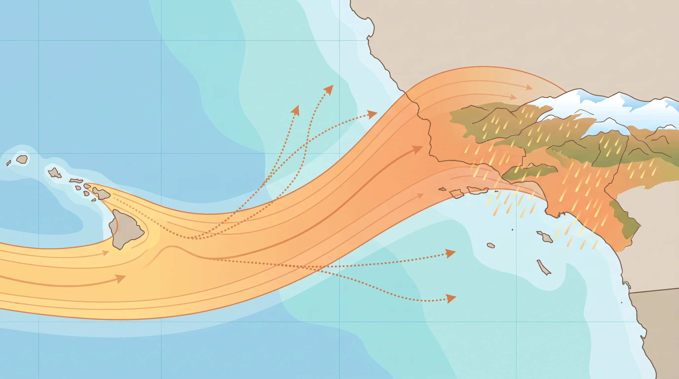
A Pineapple Express is an atmospheric river whose moisture plume traces back to the waters near Hawaii, which is where the nickname comes from. A Pineapple Express is not a separate storm type or a name for every wet California storm. It is one warm-source version of the atmospheric rivers that soak the West Coast most winters. Because its moisture starts warm and stays warm across the Pacific, a Pineapple Express usually brings heavy rain and a high snow level, not the cold powder that typical winter storms bring to Southern California's mountains.
What Is a Pineapple Express?
A Pineapple Express is the informal name for an atmospheric river that draws moisture from the subtropical Pacific near Hawaii and carries it toward the West Coast. The name describes the moisture source and path. It is not an official category, and the National Weather Service issues no Pineapple Express warning. On satellite and vapor maps, a Pineapple Express appears as a long, organized plume with one end near Hawaii and the other pointed at California, Oregon or Washington.
The Pineapple Express label describes geography, not strength, so a Pineapple Express can be weak or strong, brief or long, like any atmospheric river. Its warm source sets it apart. Air that gathers moisture over the warm subtropical Pacific near Hawaii carries more heat than air from farther north, and that warmth travels with the plume to the California coast. For how any atmospheric river forms, is rated and brings rain and snow to Southern California, see what are atmospheric rivers.
| Factor | Pineapple Express | Typical cold Pacific storm |
|---|---|---|
| Moisture source | Subtropical Pacific near Hawaii | Mid-latitude or Gulf of Alaska air mass |
| Air mass temperature | Warm for a winter storm | Cold to seasonably cool |
| Typical snow level | High, often above most local peaks | Lower, can reach mid-elevation mountains |
| Signature hazard | Heavy rain rates, runoff, debris flows | Mountain snow accumulation, colder rain |
| What confirms it | IVT/satellite plume traced to near Hawaii, NWS/WPC discussion | NWS point forecast and snow level guidance |
How Does the Moisture Reach California?
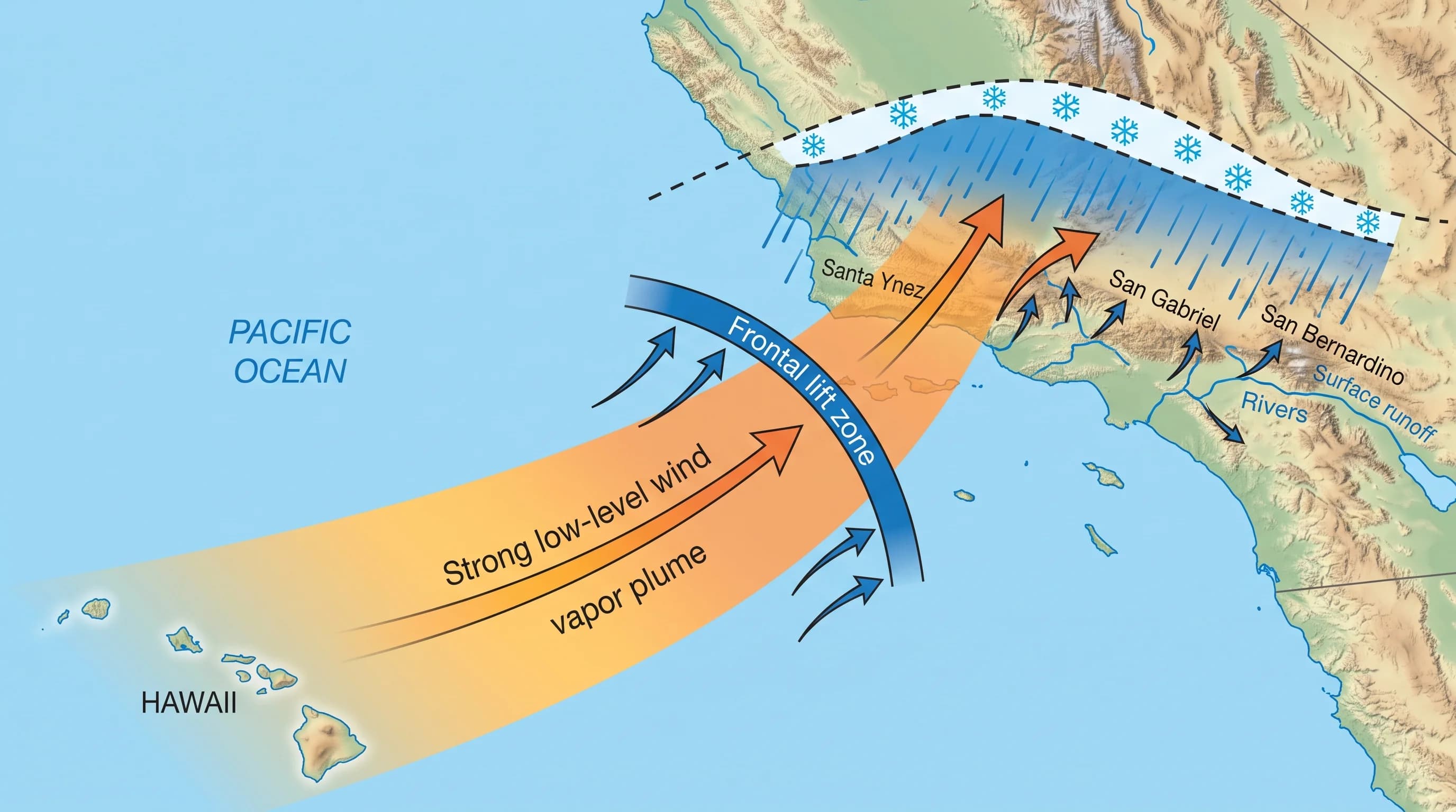
Pineapple Express moisture reaches California as water vapor carried by a fast, narrow band of low-level wind, not as rain crossing the ocean. The jet stream picks up warm, humid air near Hawaii and organizes it into a plume that can stretch thousands of miles. The vapor stays mostly invisible until a front or mountains force it upward. For how the jet stream aims Pacific storms at California, see how the jet stream steers California's storms.
At the coast, a cold front or the mountains push the moist air upward. Rising air cools, cool air holds less water vapor and the extra vapor condenses into cloud and falls as rain. In Southern California, the lift comes from the storm's front and from onshore wind running into the Transverse Ranges and San Gabriel Mountains north of the Los Angeles Basin. A Pineapple Express supplies an unusually large, warm load of moisture, so it can produce very high rain rates within a few hours.
Is Every Atmospheric River a Pineapple Express?
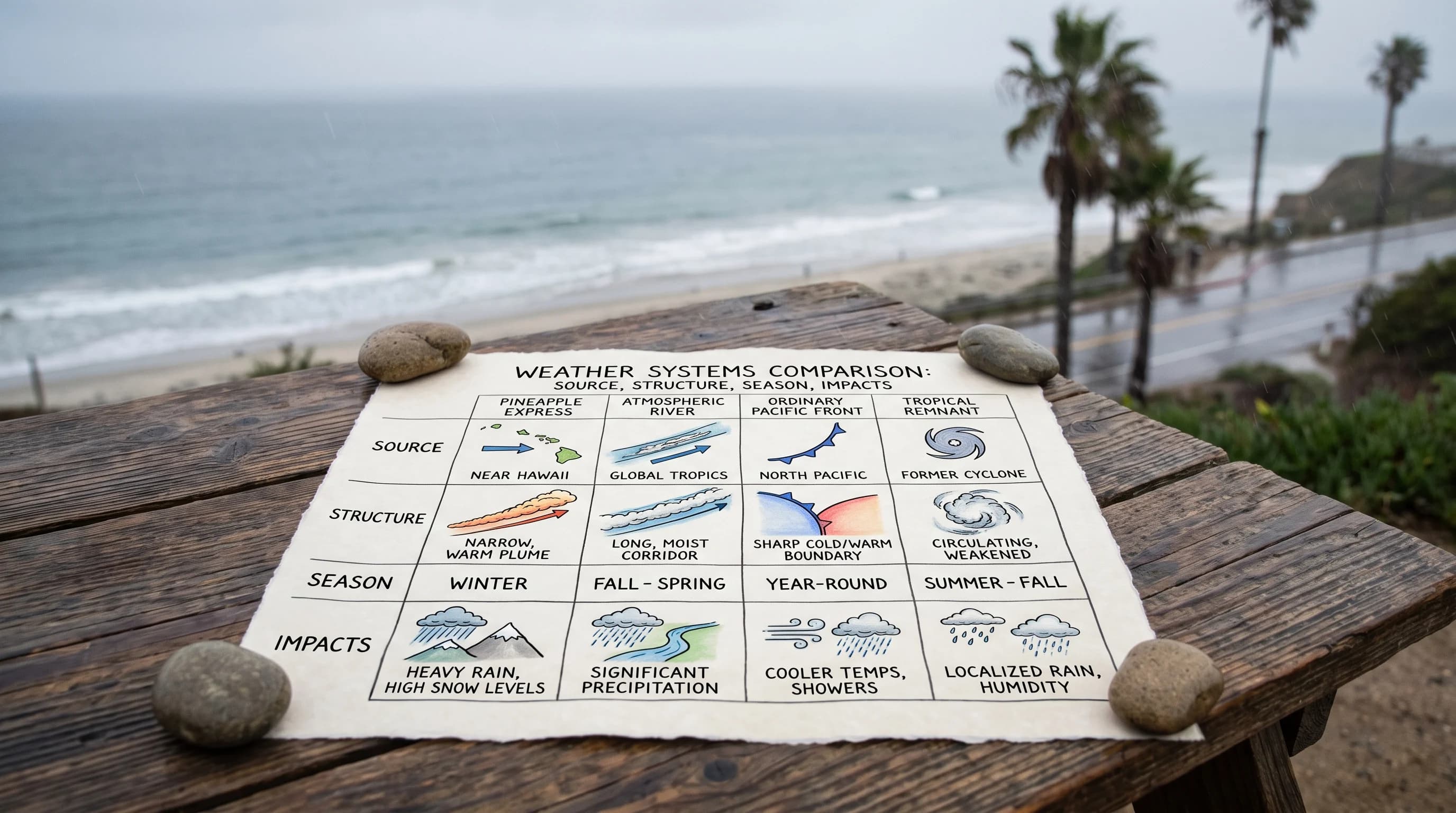
Not every atmospheric river is a Pineapple Express. Every Pineapple Express is an atmospheric river, but most atmospheric rivers reaching California come from elsewhere.
Atmospheric rivers start across a wide range of Pacific latitudes, from the deep subtropics to the Gulf of Alaska, and each source has a different temperature. A plume from colder, higher-latitude water brings a colder storm with a lower snow level. Only plumes traced to the warm water near Hawaii are called a Pineapple Express. For storms that deepen unusually fast, see bomb cyclones.
The Center for Western Weather and Water Extremes (CW3E) rates atmospheric rivers from AR 1 to AR 5 by vapor transport strength and duration, and the scale applies to a Hawaii-sourced plume like any other. A Pineapple Express can rank anywhere from a weak, mostly beneficial AR 1 to an extreme, long-lasting AR 5. The nickname tells you where the moisture came from, and the AR scale tells you how strong it is. For how the scale and integrated vapor transport (IVT) work, see what are atmospheric rivers.
When Can Southern California Be Targeted?
A Pineapple Express targets Southern California when the jet stream dips far enough south to aim a Hawaii-sourced plume at the Southern California coast instead of Central or Northern California. Storm track matters as much as moisture. The same warm plume that could soak the Bay Area or the Pacific Northwest in one setup can hit Los Angeles, Ventura and San Diego counties if the jet stream shifts south.
A Pineapple Express is a cool-season pattern, usually arriving between late fall and early spring, when the Pacific storm track reaches California. Not every winter brings a Southern California landfall; some seasons aim Hawaii-sourced plumes farther north, leaving the South Coast dry while Northern California gets soaked.
Forecast landfall can shift within a single forecast cycle. A headline saying a Pineapple Express is aimed at California does not mean Los Angeles is the target. Check the point forecast from NWS Los Angeles/Oxnard or NWS San Diego.
Why Can a Warm Moisture Plume Be Hazardous?
A warm moisture plume is hazardous because it combines high rain rates, a snow level far above the mountains and terrain that may already be vulnerable. A Pineapple Express is warm for a winter storm, so its snow level often sits high enough that precipitation that would normally fall as snow in the San Gabriel or San Bernardino Mountains falls as rain. Rain adds far more immediate runoff than snow, and there is no snowpack to hold the water back and release it slowly.
Steady lift over the Transverse Ranges and coastal mountains, combined with a long, moist plume, can produce very high rain rates for several hours. That setup causes the region's most serious urban flooding and flash flooding.
Recent wildfire burn scars are especially at risk. Burned hillsides lose the plants that hold soil and can develop a water-repellent surface that sheds rain. Debris flows can then start from rain rates that unburned ground would handle, a risk tracked by the USGS Landslide Hazards Program.
The condition of the ground, not the moisture volume alone, decides whether a Pineapple Express becomes a real hazard for a specific canyon, foothill community or mountain road.
How Do You Read a Pineapple Express Forecast?
To read a Pineapple Express forecast, look past the nickname and check the rainfall totals, timing, snow level and flood products for your location. Start with the point forecast from NWS Los Angeles/Oxnard or NWS San Diego. Add the Weather Prediction Center's rainfall outlook for expected totals and timing. A flood watch or warning for your area says far more than the nickname, and the NWS flood safety guidance explains what to do once a watch becomes a warning.
A satellite or IVT map showing a plume from Hawaii to California confirms a Pineapple Express only if you read the legend. Check whether the map is a forecast or an observation, and whether its colors show vapor transport, cloud-top temperature or something else. Before driving into the mountains during or after one of these storms, including through the passes beyond Woodland Hills, check the snow level and road advisories. A warm storm's snow level can drop at the tail end and bring brief mountain snow.
A Pineapple Express describes where an atmospheric river's moisture came from. It is not a formal storm category or a promise of any outcome for Downtown Los Angeles, Pasadena or any other Southern California destination. Before the storm arrives, check the NWS rainfall forecast, snow level and flood products for your location, and check current conditions on WeatherLA's Los Angeles pages.