winterphenomenaclimate sciencecity guide

Snow in LA? Rare Downtown, Routine Uphill

By WeatherLA|Published |Last updated |8 min read
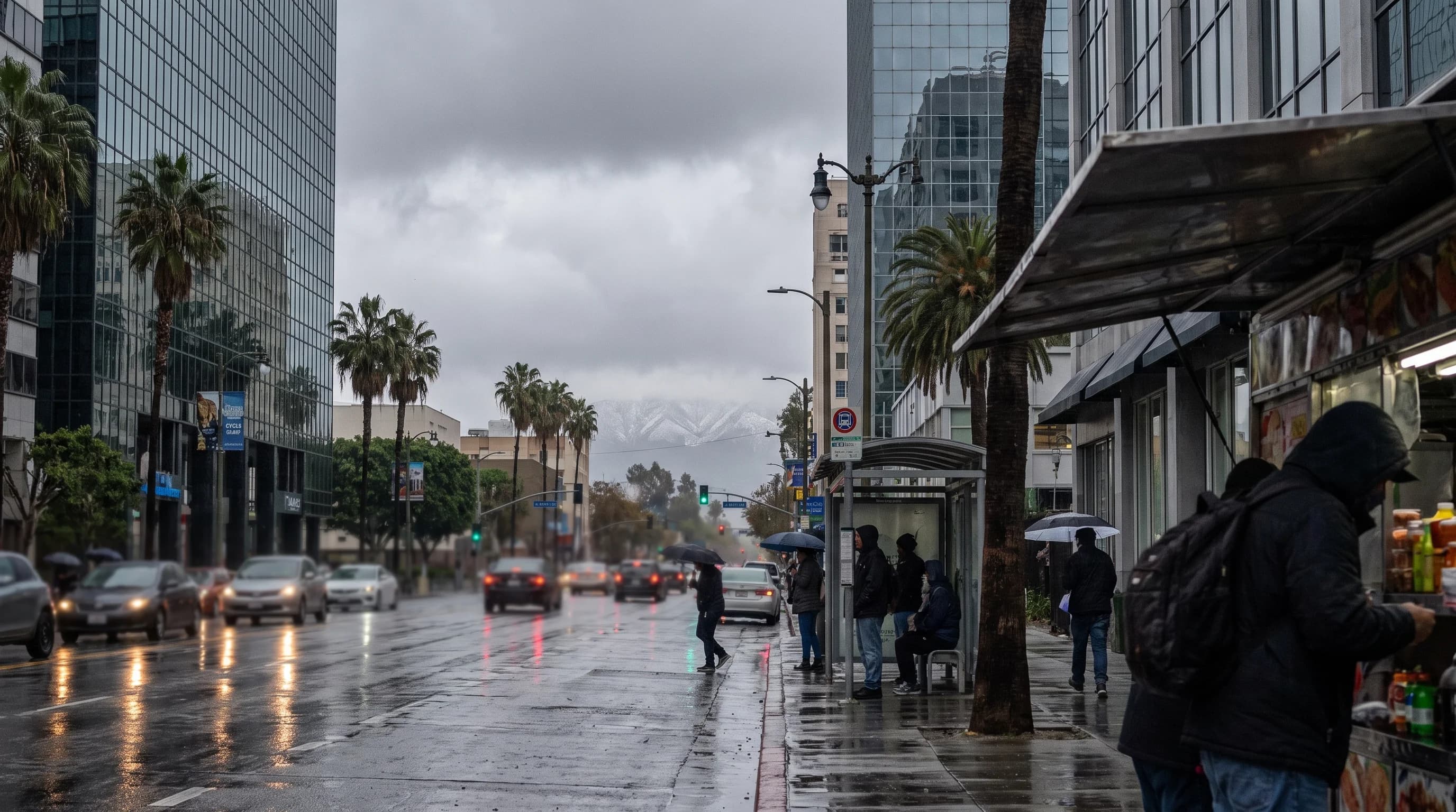
A cold winter morning in Downtown Los Angeles with rain-wet streets and snow visible only on the high San Gabriel peaks in the distance

Key Takeaways

  • Downtown Los Angeles and the surrounding basin have essentially no confirmed measurable snowfall in the modern climate record; the ocean keeps even cold winter storms falling as rain.
  • What people mistake for LA snow is almost always hail or graupel, small ice pellets from cold-season thunderstorms that can briefly whiten the ground and melt fast.
  • The freezing level, the elevation where air temperature crosses 32°F, is why the same storm can rain on downtown while snowing heavily in the San Gabriel Mountains an hour away.
  • January 1949 remains the most widely documented case of snow reaching low-elevation Southern California, a rarity even by the standards of a century of winters.
  • Big Bear Lake and Wrightwood, both above 6,000 feet in the San Gabriel and San Bernardino Mountains, get reliable winter snow almost every season, unlike the LA Basin itself.
  • Before heading uphill after a storm, check the NWS snow level forecast and Caltrans QuickMap for chain controls, since both can change within hours.

Measurable snow in the Los Angeles lowlands is exceptionally rare. Downtown Los Angeles sits near sea level in a basin that the Pacific Ocean keeps mild even during winter storms, so cold systems almost always arrive as rain, not snow. The San Gabriel Mountains just north of the city are a different story: the same storm that soaks downtown in cold rain can bury Wrightwood and Big Bear Lake in a foot or more of snow within an hour's drive of the city.

Does it snow in Los Angeles?

In the lowland city, essentially never in any way that accumulates. Downtown Los Angeles, the Los Angeles Basin, and most of the county below roughly 1,000 feet of elevation have no confirmed measurable snowfall in the modern climate record kept by the National Weather Service Los Angeles/Oxnard office. What residents sometimes mistake for snow is usually hail or graupel, small pellets of ice or soft, rimed ice that form in cold-season thunderstorms and can briefly whiten lawns and streets before melting.

Graupel forms when supercooled cloud droplets freeze onto a falling ice crystal, and it can look remarkably like a light snow accumulation on video, which is why viral "it's snowing in LA" clips circulate almost every winter without being actual snow. Real snow is far more routine 60 to 90 minutes north and east, in the San Gabriel and San Bernardino Mountains, where elevations above 5,000 to 6,000 feet receive multiple snow events most winters.

Los Angeles Basin vs. Nearby Mountains: Same Storm, Different Result
LocationApproximate elevationWhat a cold winter storm typically brings
Downtown Los AngelesNear sea levelCold rain; measurable snow is exceptionally rare
PasadenaA few hundred feetCold rain, with snow-capped peaks visible to the north
WrightwoodAround 6,000 feetRegular winter snow accumulation most seasons
Big Bear LakeRoughly 6,750 feetRegular winter snow accumulation and lift-served skiing

Why does elevation decide whether an LA storm falls as rain or snow?

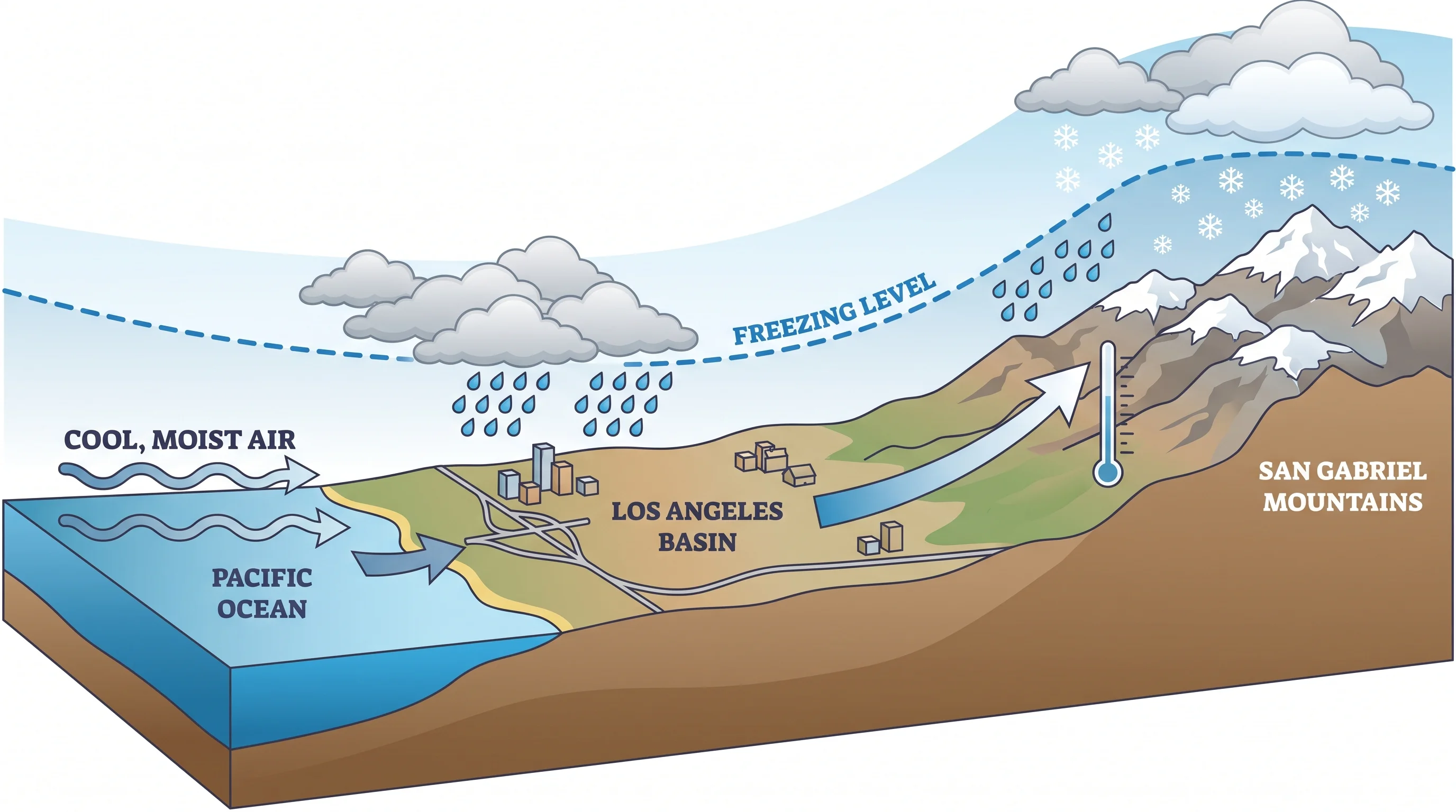
Whether precipitation reaches the ground as rain or snow depends on the freezing level, the altitude at which air temperature crosses 32°F, and more precisely on the wet-bulb temperature, which accounts for evaporative cooling as a snowflake falls through the air column beneath it. When the freezing level sits high, a common situation in the Los Angeles Basin because the Pacific Ocean moderates coastal air temperatures year-round, any snow that forms high in a storm melts long before it reaches sea level and lands as rain. During a cold winter storm the freezing level can drop to 3,000 to 5,000 feet, low enough to paint the peaks of the San Gabriels white while downtown, sitting near sea level, gets a cold, gray rain from the same system.

This is also why a single storm can produce two completely different experiences an hour apart. Someone driving from downtown up the Angeles Crest Highway toward Wrightwood can leave in a rainstorm and arrive in falling snow simply by climbing several thousand feet through the freezing level. The ocean's moderating effect is strongest at the coast and weakens with distance inland and with elevation, which is the core reason Southern California's snow line and its rain line are really the same line, just described from opposite ends.

Cross-section illustration from the Pacific coast to the San Gabriel Mountains showing ocean-moderated air near sea level, a labeled freezing level line rising and falling with storm strength, cold rain falling on the Los Angeles Basin, and snow accumulating above the snow line on the high peaks
The same winter storm can produce cold rain in the Los Angeles Basin and heavy snow in the San Gabriels, because the freezing level, not the calendar, decides where rain turns to snow.

When could snow reach the Los Angeles lowlands?

It takes an unusual stack of conditions arriving together: an unusually cold upper-level low pressure system, a snow level forecast by the NWS LOX office down near sea level, and enough moisture in that cold air mass to produce precipitation instead of just clearing skies behind the front. Southern California gets cold, dry troughs most winters that drop the snow level without much moisture, and it gets wetter, milder storms that never get cold enough at low elevation.

The rare combination of both factors at once is what it takes even to put flakes in the air over the basin, and it still does not guarantee accumulation, since surface temperatures and ground warmth left over from the prior days matter too. A modeled snow level forecast dropping toward sea level in an NWS product is a signal to watch, not a promise that the city will see accumulating snow. Readers planning around a cold storm should treat any lowland snow chance as a low-probability possibility worth monitoring, not an expectation.

What does Los Angeles snow history actually show?

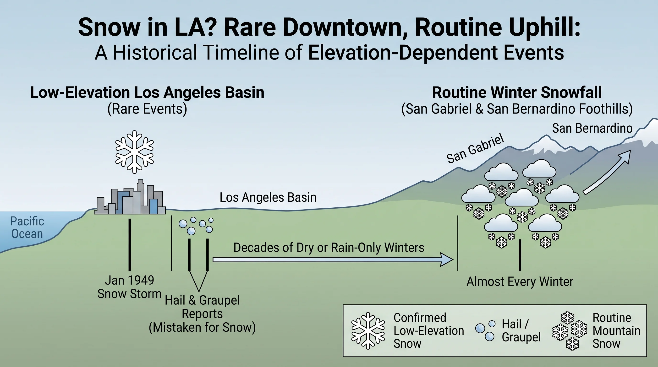
The most frequently cited event is the storm of January 1949, when snow fell across much of the Los Angeles Basin and was documented at low elevations across the region, one of the very few times in the twentieth-century record that lowland Southern California saw widespread snow rather than an isolated flurry. Other cold snaps over the decades, including scattered reports in the early 1960s and occasional graupel and hail events that get mislabeled as snow in local retellings, have added to a folklore of Los Angeles snow that is larger than the verified record supports.

The National Weather Service and NOAA's long-term station records are the authoritative source for confirming any specific date and location, and any claim about a particular year's lowland snowfall should be checked against those records rather than repeated secondhand. What is well documented and uncontroversial is the mountain side of the ledger: the San Gabriel and San Bernardino high country receives measurable snow in nearly every winter, sometimes many separate storms in a single season, which is the reliable half of the region's snow story.

A timeline graphic marking confirmed low-elevation Los Angeles snow events including the January 1949 storm, alongside separate markers for hail and graupel reports often mistaken for snow and routine winter snowfall in the San Gabriel and San Bernardino foothills
Verified lowland snow in the Los Angeles Basin is rare enough that individual storms, like January 1949, are still cited generations later, while the nearby mountains see routine snow almost every winter.

Where can you find reliable snow near Los Angeles?

For travelers who actually want to see or play in snow, the reliable destinations sit at elevation in the San Gabriel and San Bernardino Mountains rather than in the city itself. Big Bear Lake, at roughly 6,750 feet, and Wrightwood, at around 6,000 feet, are the two most accessible mountain communities from the LA Basin and both see regular winter snow accumulation and lift-served skiing in a typical season.

Lower foothill communities such as Pasadena, which sits at the base of the San Gabriels at only a few hundred feet of elevation, almost never see their own snow but offer some of the best close-up views of snow-capped peaks after a cold storm, particularly looking north from areas near the mountain front. Each destination's own climatology, elevation, and typical snow season are best checked on that destination's page rather than assumed from the regional pattern, since a few thousand feet of elevation difference between two mountain towns can mean a meaningfully different snow season. The broader picture across the region, including desert and coastal mountain ranges beyond the San Gabriels, is covered in where does it snow in Southern California.

How should you check an incoming snow chance?

Start with the point forecast and snow level guidance from the NWS Los Angeles/Oxnard office for the LA Basin and San Gabriels, or the NWS San Diego office for areas farther south and east. The snow level, the elevation above which precipitation is expected to fall as snow rather than rain, is typically updated with each forecast package and can shift by a thousand feet or more as a storm evolves, so the number worth checking the morning of a trip is not the same as the number from three days earlier.

Anyone driving up to the mountains during or after a winter storm should also check Caltrans QuickMap for chain control requirements and road status on routes like State Route 2 and State Route 18, since chain controls can be imposed with little notice and mountain roads close entirely during the heaviest snowfall. The NWS winter weather safety guidance covers driving in snow and cold-weather precautions for anyone unfamiliar with mountain winter conditions. For a wider comparison of how this pattern plays out elsewhere in the region, see does it snow in Palm Springs and does it snow in Big Bear Lake, which each cover their own destination's climatology in more depth than a regional summary can.

The short version holds up under scrutiny: Los Angeles itself is a rain city even in its coldest storms, and the snow that gives Southern California its postcard image of palm trees against white peaks is happening a few thousand feet higher, not downtown. Before planning a trip around snow, whether that means chasing a rare lowland flurry or driving up to Big Bear Lake for a weekend, check the current temperature and snow level on WeatherEscape's Los Angeles forecast pages and confirm road conditions before you climb into the mountains.

Frequently Asked Questions

Does it snow in Los Angeles?

Measurable snow almost never falls in the Los Angeles lowlands, including Downtown LA and the broader basin. The National Weather Service Los Angeles/Oxnard office has no confirmed measurable snowfall on record for the modern era at low elevation. What people see on video and call snow is usually hail or graupel, small ice pellets that form in cold winter thunderstorms and melt quickly.

Why does elevation decide whether an LA storm falls as rain or snow?

Precipitation type depends on the freezing level, the altitude where temperature crosses 32°F, and the wet-bulb temperature a snowflake experiences as it falls. Los Angeles sits near sea level in an ocean-moderated basin, so the freezing level is usually too high for snow to survive the drop to the ground, even when the same storm is cold enough to snow heavily a few thousand feet up in the San Gabriel Mountains.

When could snow reach the Los Angeles lowlands?

It takes a rare combination: an unusually cold storm system, a forecast snow level dropping close to sea level, and enough moisture left in that cold air to actually produce precipitation. Southern California gets cold, dry troughs and separate wetter, milder storms most winters, but rarely both cold and wet at once, which is why even a promising snow level forecast should be treated as a possibility to watch, not an expectation.

What does Los Angeles snow history actually show?

The January 1949 storm is the most frequently cited and well-documented case of snow reaching the Los Angeles Basin at low elevation. Other historical reports exist, but many popular retellings blend in hail, graupel, and foothill-only observations, which is why any specific date or amount should be checked against official National Weather Service and NOAA station records rather than repeated secondhand.

Where can you find reliable snow near Los Angeles?

The San Gabriel and San Bernardino Mountains are the reliable option, particularly Big Bear Lake at roughly 6,750 feet and Wrightwood at around 6,000 feet, both within about an hour or two of the city and both seeing regular winter snow accumulation most seasons. Lower foothill towns like Pasadena rarely get their own snow but offer strong views of snow-capped peaks after a cold storm.

How should you check an incoming snow chance?

Check the point forecast and snow level from NWS Los Angeles/Oxnard or NWS San Diego depending on location, since the snow level can shift by a thousand feet or more as a storm evolves. Before driving into the mountains, check Caltrans QuickMap for chain control requirements and road closures, and review NWS winter weather safety guidance if you are not used to driving in snow.

What is Los Angeles' coldest month?

December and January are typically the coldest months in the Los Angeles Basin, with average lows in the low-to-mid 40s Fahrenheit at low elevation stations, per NOAA 1991-2020 Climate Normals. Even in these coldest weeks, daytime highs in the basin usually stay well above freezing, which is a major reason lowland snow is so rare regardless of how cold a storm feels.

Related Destinations

Live Los Angeles Conditions

Compare temperature, wind, clouds, and comfort across the map.

See which microclimates are clear, cool, windy, smoky, or warming up right now.

Open the Weather Map
Destinations☀️Smog Forecast🌫️Smog Heat Map🔒Privacy Policy📄Terms of Service