winterphenomenatrip planningcity guide

Big Bear Really Gets Snow, but Town and Slopes Differ

By WeatherLA|Published |Last updated |8 min read
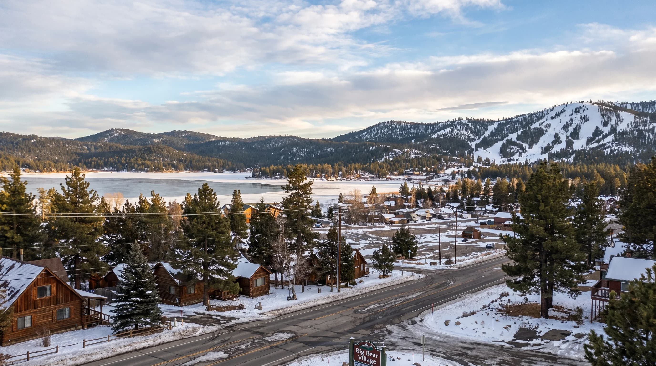
Big Bear Lake and the surrounding town after a moderate winter storm, with patchy snow on sunlit streets and deeper snow visible on the shaded ridgelines and ski slopes above

Key Takeaways

  • Big Bear Lake sits at roughly 6,750 feet in the San Bernardino Mountains and receives measurable winter snow in nearly every season, unlike the Los Angeles lowlands or Palm Springs, where snow is rare or nonexistent.
  • The core snow season runs from about late November through March, with December through February typically producing the most frequent and heaviest storms, though early and late-season storms outside that window are possible.
  • Snowfall is not uniform across Big Bear Valley: the lake and town sit in a lower bowl than the ridgelines above them, so a storm can drop a foot on Snow Summit or Snow Valley while leaving the valley floor with a lighter, patchier accumulation.
  • Storm size varies enormously, from light dustings that melt within a day to multi-day systems like the late February 2023 blizzard that buried the valley in several feet and closed roads for days, an extreme outlier rather than a typical storm.
  • A resort snow report describes conditions at the ski area, often boosted by snowmaking, and is not the same as a measured snow depth in town, so travelers should cross-check NWS observations, resort reports, and webcams by location and timestamp rather than relying on just one.
  • Caltrans QuickMap and CHP updates, not a webcam or a single forecast, are the sources to check for chain control requirements on State Route 18 and State Route 38 before driving up, since requirements can change within hours during an active storm.

Big Bear Lake is the reliable snow answer for Southern California, unlike the coastal lowlands or the desert floor. Sitting at roughly 6,750 feet in the San Bernardino Mountains, the valley gets measurable snow in nearly every winter. But "Big Bear gets snow" is not the same as "Big Bear gets the same snow everywhere." The town and lake sit in a lower bowl than the ridgelines and ski slopes around them, so the storm that buries Snow Summit can leave the valley floor with a thinner, patchier layer that melts off within a day. The real story here is elevation within the mountain, storm-to-storm variability, and what to actually check before you drive up.

Does Big Bear Lake actually get snow?

Yes, and it is not a marginal or rare event the way it is in the Los Angeles basin. Big Bear Valley receives measurable winter snow in nearly every season, based on NOAA 1991 to 2020 Climate Normals for the area, and it hosts two operating ski areas, Snow Summit and Snow Valley, that depend on that pattern holding up most winters. What is worth separating out is the difference between seasonal snowfall and continuous snow cover. Big Bear gets snow events throughout the season, but the valley floor does not stay blanketed in white from November through March the way a true alpine climate might.

Between storms, clear skies and daytime sun at this elevation can melt exposed snow on sidewalks and south-facing streets within a day or two, even while snow lingers longer in shaded areas and on the slopes above town. A visitor who checks a resort snow report and assumes the town looks the same is often surprised either way, by bare pavement on a "snow season" week or by a foot of fresh snow that a lowland forecast never mentioned.

When does Big Bear usually receive snow?

The core winter season runs from late November through March, with December, January, and February typically bringing the most frequent and heaviest storms. Early-season storms in October or November do happen in an active year, and the season can stretch into April with a late cold system, but neither is something to plan a trip around without checking a current forecast first. Some winters are wetter and colder than others; a strong El Niño or La Niña pattern, or a particularly active storm track, can shift how many storms actually reach Southern California in a given year.

Month-by-month likelihood drawn from climate normals is useful for deciding roughly when to plan a winter trip, but it describes a long-term average, not the forecast for any specific week. The days before a trip are still the time to check the actual point forecast, not the seasonal pattern.

Big Bear Valley Winter Snow Season, Month by Month
PeriodTypical snow likelihoodWhat to expect
Late Oct to mid NovLowOccasional early cold storm; not reliable for a snow trip
Late Nov to DecModerate to highSeason typically opens; resorts begin snowmaking and grooming
Jan to FebHighestPeak season; most frequent and heaviest storms, deepest base
MarchModerateLate-season storms possible; base can still be substantial
AprilLowOccasional late storm; melt-off accelerates on warm days

Why does snowfall vary so much around Big Bear Valley?

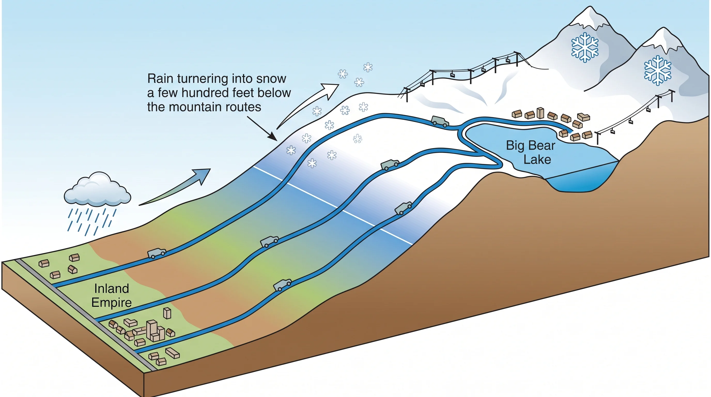
Big Bear Lake and the town sit in a valley bowl at around 6,750 feet, while the terrain that frames the valley rises several hundred feet higher on the surrounding ridgelines and ski slopes. That elevation gap matters more than it sounds like it should. Snow level, the altitude above which a storm's precipitation falls as snow rather than rain, can sit right around the valley floor's elevation during a marginal storm, meaning the town gets a cold rain or wet mix while slopes just a few hundred feet higher get accumulating snow.

Slope orientation adds another layer: north-facing terrain that stays shaded holds snow far longer than south-facing streets and parking lots that see direct winter sun even on a cold day. Wind-driven storms can also dump disproportionately more snow on wind-exposed ridgelines through a process called terrain enhancement, where rising air forced up and over higher terrain wrings out extra moisture compared to the sheltered valley below.

The practical result is that a single number, like a summit snow report from Snow Summit or Snow Valley, describes conditions at that specific elevation and slope, not the town of Big Bear Lake or Big Bear City a few hundred feet lower. Treating a resort's reported base depth as what you will find on Main Street is one of the most common mismatches visitors run into.

An elevation-profile diagram from the Inland Empire up three highway approaches to Big Bear, showing changing snow level, town elevation, resort summit, and rain-to-snow transition
Big Bear Lake's town sits lower than the ridgelines and ski slopes around it, so the same storm can bring a cold rain to the valley floor while dropping accumulating snow a few hundred feet higher.

How much snow can a Big Bear storm actually bring?

The range is wide, and most winter storms sit well below the dramatic end of it. A typical weaker system might drop a light dusting to a few inches, enough to whiten roofs and shaded areas but not enough to require chains for long. A stronger, colder storm can bring six inches to a foot or more at higher elevations over a day or two, the kind of event that fills in the base at Snow Summit and Snow Valley and gives the town a solid, photogenic covering. Multi-day systems that tap deep moisture and cold air together are less frequent but produce the storms locals actually remember by name or year.

The late February 2023 storm is the clearest recent example of the far end of that range: a slow-moving system buried the San Bernardino Mountains under several feet of snow over multiple days, trapped residents, and closed roads into Big Bear for an extended period while crews worked to clear routes. It is a useful reference for what a worst-case storm looks like, but it is a dated extreme, not a typical winter storm, and treating it as the baseline expectation for "does it snow in Big Bear" would badly overstate what most winter weekends actually bring.

Where should you check current snow depth?

No single source tells the whole story, so cross-checking matters. The NWS San Diego historical weather record documents how variable San Bernardino Mountain snow events can be, while current NWS point forecasts and observations give official numbers tied to a specific station and time, the most reliable read on what is actually falling or has fallen in a given spot. Resort snow reports from Big Bear Mountain Resort, which operates Snow Summit and Snow Valley, describe base depth and surface conditions on the runs themselves, and that base is often supplemented by snowmaking, not purely natural snowfall, so it is not a stand-in for a town snow total.

Public webcams are useful for a quick visual check, confirming whether snow is currently falling or covering a specific street or slope at the timestamp shown, but a webcam cannot report a measured depth. A parking lot that looks solidly white on camera could be two inches deep or ten, and only a station observation or a resort's stated snow total will tell you which.

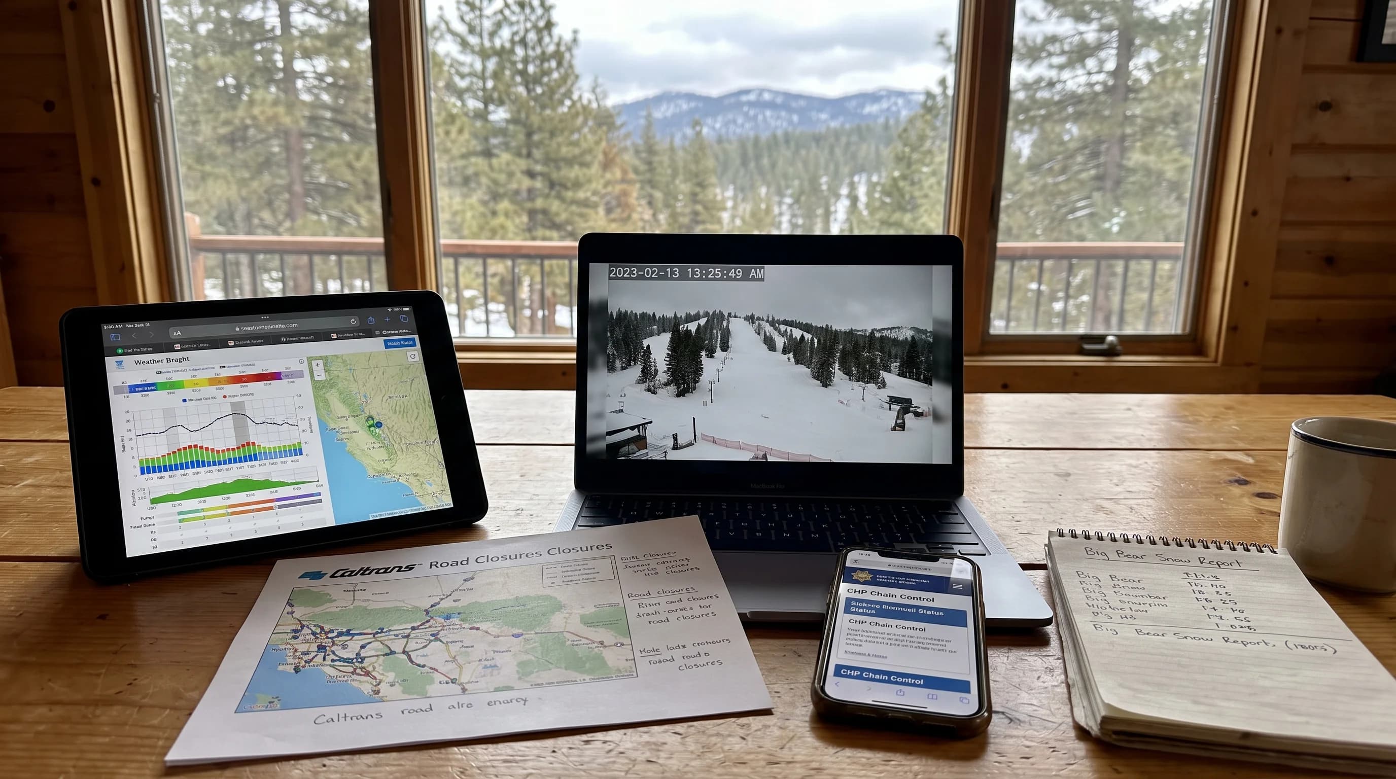
A trip-planning dashboard comparing NWS point forecast, measured snow, webcam timestamp, Caltrans closure, CHP chain status, and resort report location
Checking Big Bear snow before a trip means comparing several sources by location and timestamp, since an NWS observation, a resort report, and a webcam each answer a slightly different question.

How do roads and chain controls change a snow trip?

The main highway approaches into Big Bear Valley are State Route 18, which climbs from the San Bernardino foothills, and State Route 38, which approaches from the north side near Redlands and Big Bear City. Both roads gain thousands of feet of elevation on the way up, and both are subject to chain control requirements or full closures during active winter storms. Exactly which route stays open, and which requires chains, varies by storm, so this article will not predict which one to take on a given day. What matters is checking current status close to departure, not relying on a forecast made two or three days earlier.

Before heading up, check Caltrans QuickMap for real-time road status and chain control levels, and check with the California Highway Patrol for enforcement and closure updates, since both can change within hours as a storm moves through the mountains. Vehicles without four-wheel or all-wheel drive and proper traction should carry chains during winter storm season regardless of the forecast at the time of departure, since conditions that were clear in the morning can require chains by afternoon. Wrightwood, another San Bernardino Mountains snow destination roughly comparable in elevation to Wrightwood, faces similar approach-road dynamics on Highway 2, which is a useful comparison if a Big Bear route is closed and a nearby alternative is worth considering.

The short version is that Big Bear Lake earns its reputation as Southern California's dependable snow destination, but "dependable" describes the season, not any single day or any single spot in the valley. A trip that accounts for the gap between valley floor and ridgeline, checks more than one snow source, and confirms road status right before departure will handle the variability that catches first-time visitors off guard. For how this pattern compares to places where snow is the exception rather than the rule, see does it snow in Los Angeles and does it snow in Palm Springs, and check WeatherEscape's Big Bear forecast pages before you head up.

Frequently Asked Questions

Does it snow in Big Bear Lake?

Yes, reliably. Big Bear Lake sits at roughly 6,750 feet in the San Bernardino Mountains and gets measurable snow in nearly every winter, based on NOAA 1991 to 2020 Climate Normals for the area. That said, "it snows in Big Bear" does not mean snow covers the ground continuously all winter. Between storms, sun and daytime temperatures above freezing can melt exposed snow on the valley floor within days, even while shaded slopes and higher elevations hold their base longer.

When does Big Bear usually receive snow?

The core season runs from late November through March, with December, January, and February typically bringing the most frequent and heaviest storms. Occasional early storms in October or November and late storms into April are possible in an active year, and some winters run drier than others. Month-by-month likelihood from climate normals is useful for general planning, but it is not a substitute for checking the actual forecast in the days before a specific trip.

Why does snowfall vary so much around Big Bear Valley?

Big Bear Lake and the town around it sit in a valley bowl at around 6,750 feet, while the ridgelines and ski slopes that frame the valley, including Snow Summit and Snow Valley, rise several hundred feet higher and catch more direct exposure to storm winds. Snow level, slope orientation, and localized terrain enhancement mean the same storm can drop noticeably more snow on a north-facing slope above town than on the sunnier valley floor. A single summit snow report is a report for that summit, not a reliable stand-in for what the town itself received.

How much snow can a Big Bear storm actually bring?

The range is wide. Many winter storms bring a light dusting to a few inches that can melt off within a day or two on sunny valley streets. Stronger multi-day storms can drop one to two feet at higher elevations. The late February 2023 storm, widely documented as a blizzard that buried the San Bernardino Mountains under several feet of snow and closed roads into Big Bear for days, is the extreme end of the range and should be treated as a dated outlier, not the baseline expectation for a typical winter storm.

Where should visitors check current snow depth?

Cross-check more than one source. NWS point observations and forecasts give official numbers for specific stations, resort snow reports from Big Bear Mountain Resort describe conditions at the ski area itself (often supplemented by snowmaking, not just natural snowfall), and public webcams can confirm visible cover on streets or slopes at a specific timestamp. A webcam is useful for seeing whether snow is currently falling or covering the ground, but it cannot substitute for a measured depth, since visual cover can look similar at very different actual depths.

How do roads and chain controls change a snow trip to Big Bear?

The main highway approaches into Big Bear Valley are State Route 18 and State Route 38, both of which climb through terrain that can require tire chains or close outright during active storms. Caltrans QuickMap and California Highway Patrol updates are the sources to check immediately before departure, since chain control requirements and closures can change within hours as a storm moves through, and neither a forecast made days earlier nor a webcam snapshot will reflect a control that was just imposed.

Is Big Bear snow natural or machine-made?

Both, depending on where you are and when. Natural snowfall is what covers streets, trees, and the lake area during and after a storm, and it is what this article describes throughout. Ski areas including Snow Summit and Snow Valley also run snowmaking systems to supplement natural snowfall and extend the season on their runs, which is why a resort can report a solid base even during a dry stretch when the town itself has little snow on the ground.

What is the coldest it has ever been in Big Bear?

Big Bear Valley regularly sees overnight lows well below freezing in December and January, consistent with its roughly 6,750-foot elevation, and specific record-cold readings are best confirmed against official NWS and NOAA station records rather than repeated secondhand, since record claims vary by exact station location and period of record. What is consistent year to year is that nighttime cold at this elevation is routine, not exceptional, which is a major reason snow that falls tends to stick longer here than in nearby lower foothill towns.

Does snow in Big Bear mean the roads are closed?

Not necessarily. Light and moderate snow events are common enough that Big Bear Valley functions through most of them, with plowing and chain controls rather than full closures. Full road closures on State Route 18 or State Route 38 tend to happen during the heaviest, fastest-moving storms or when accumulated snow and ice make plowing temporarily unsafe, which is why checking Caltrans QuickMap and CHP status close to departure time matters more than assuming either a closure or an open road based on the forecast alone.

Related Destinations

Live Los Angeles Conditions

Compare temperature, wind, clouds, and comfort across the map.

See which microclimates are clear, cool, windy, smoky, or warming up right now.

Open the Weather Map
Destinations☀️Smog Forecast🌫️Smog Heat Map🔒Privacy Policy📄Terms of Service