winterphenomenatrip planningcity guide

Palm Springs Snow: Two Climates, One Tram Ride

By WeatherLA|Published |Last updated |8 min read
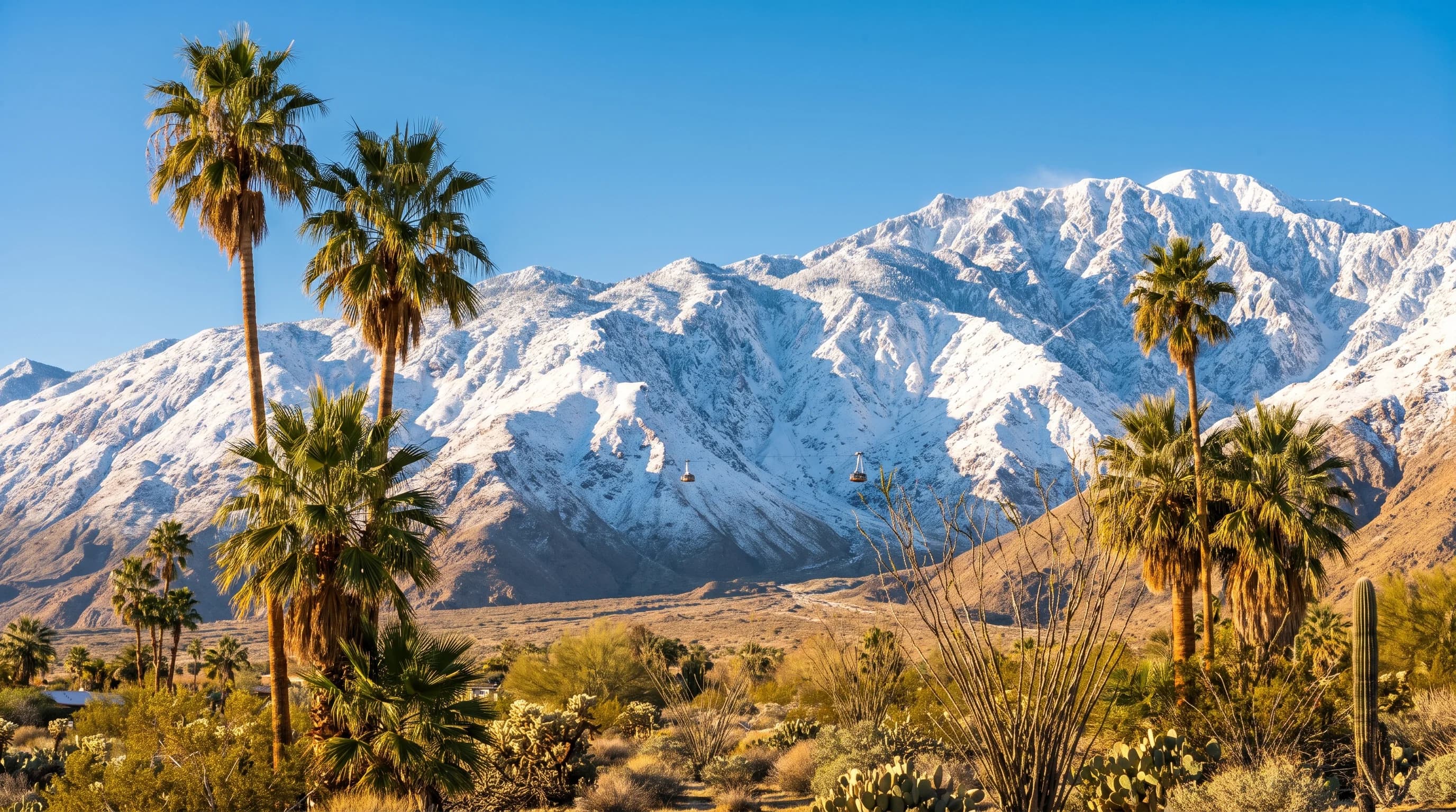
Palm Springs palm trees and sunlit desert foreground beneath a freshly snow-covered Mount San Jacinto, showing the dramatic valley-to-summit winter contrast

Key Takeaways

  • Palm Springs sits at about 487 feet of elevation, and measurable snow on the desert floor is exceptionally rare, with most winter storms arriving as cold rain and wind instead.
  • The Palm Springs Aerial Tramway climbs from about 2,643 feet at the Valley Station to roughly 8,516 feet at the Mountain Station in about ten minutes, crossing one of the steepest elevation gains available to visitors anywhere in the country.
  • San Jacinto Peak reaches 10,834 feet directly above the Coachella Valley, so the same winter storm that rains on Palm Springs can bury the upper mountain in a foot or more of snow.
  • The snow level, the elevation where a storm's precipitation switches from rain to snow, typically sits around 5,000 to 7,000 feet in a normal Southern California winter storm, which is why the tramway route often crosses from rain into snow partway up.
  • Confirmed snow reaching the Palm Springs valley floor is rare and thinly documented, unlike San Jacinto's upper elevations, which see reliable winter snowpack in nearly every season based on NOAA's 1991 to 2020 Climate Normals.
  • Because valley and summit conditions can differ by 30 to 40°F on the same afternoon, check the Palm Springs forecast and the tramway's mountain conditions separately, and confirm tram operating status before planning a snow trip.

The Palm Springs desert floor, sitting at only about 487 feet above sea level, almost never sees snow. But ride the Palm Springs Aerial Tramway for roughly ten minutes and you can step out into a snow-covered alpine forest at the Mountain Station, over 8,500 feet up the same peak. Few places in the United States pack that much winter contrast into a single ride: a desert warm enough for shorts at the bottom, and a mountain cold enough for a parka at the top, on the same storm day.

Does it snow in Palm Springs?

On the Coachella Valley floor, essentially never in a way that sticks. Palm Springs sits at roughly 487 feet of elevation in a low desert basin, and the National Weather Service San Diego office, which covers the Coachella Valley, has no pattern of routine measurable snowfall at that elevation. The valley's winter storms are typically cold rain, gusty wind, and occasional graupel rather than accumulating snow. Meanwhile, the mountain wall that rises directly behind the city, Mount San Jacinto, receives regular winter snow above roughly 6,000 to 7,000 feet in most years.

The tramway's Valley Station, at about 2,643 feet, sits in a transition zone that occasionally sees a dusting during an unusually cold storm, while the tram's Mountain Station, at roughly 8,516 feet near San Jacinto Peak, sees genuine winter snowpack most seasons. This is the same split that defines snow across low-elevation Southern California more broadly, covered in does it snow in Los Angeles, except Palm Springs compresses the desert-to-alpine transition into a shorter horizontal distance and a more dramatic vertical rise than almost anywhere else in the region.

Palm Springs Desert Floor vs. Tramway Vs. San Jacinto Peak
LocationApproximate elevationTypical winter storm conditions
Palm Springs (desert floor)About 487 feetCold rain and wind; measurable snow is exceptionally rare
Tramway Valley StationAbout 2,643 feetCold rain, with an occasional light dusting in colder storms
Tramway Mountain StationAbout 8,516 feetRegular accumulating snow, often several inches to over a foot per storm
San Jacinto Peak10,834 feetConsistent winter snowpack lasting weeks between storms

How can one storm bring valley rain and mountain snow?

The same storm can rain on Palm Springs and bury San Jacinto in snow because the peak rises more than 10,000 feet directly above the Coachella Valley floor within just a few horizontal miles, one of the steepest escarpments in the contiguous United States. As air is forced up that wall, it cools with altitude, and a storm's snow level, the elevation above which precipitation falls as snow rather than rain, cuts across that rise at some point. Below the snow level, precipitation lands as rain on the desert; above it, the same moisture falls as snow on the upper mountain.

During a typical winter storm the snow level might sit around 5,000 to 7,000 feet, low enough to whiten the upper tram route while the valley floor gets only rain and wind. During a colder, stronger storm the snow level can drop several thousand feet lower, closer to the Tramway Valley Station.

The Palm Springs Aerial Tramway makes this elevation change unusually easy to observe firsthand, since the ride from the Valley Station to the Mountain Station covers nearly 6,000 vertical feet in about ten minutes, passing through several distinct vegetation zones on the way. That is geography, not a guarantee of conditions on any given day: the tram's operating status, and whether snow is actually falling or accumulating at the top on a given date, should always be checked against the tramway's own current conditions report rather than assumed from the elevation alone.

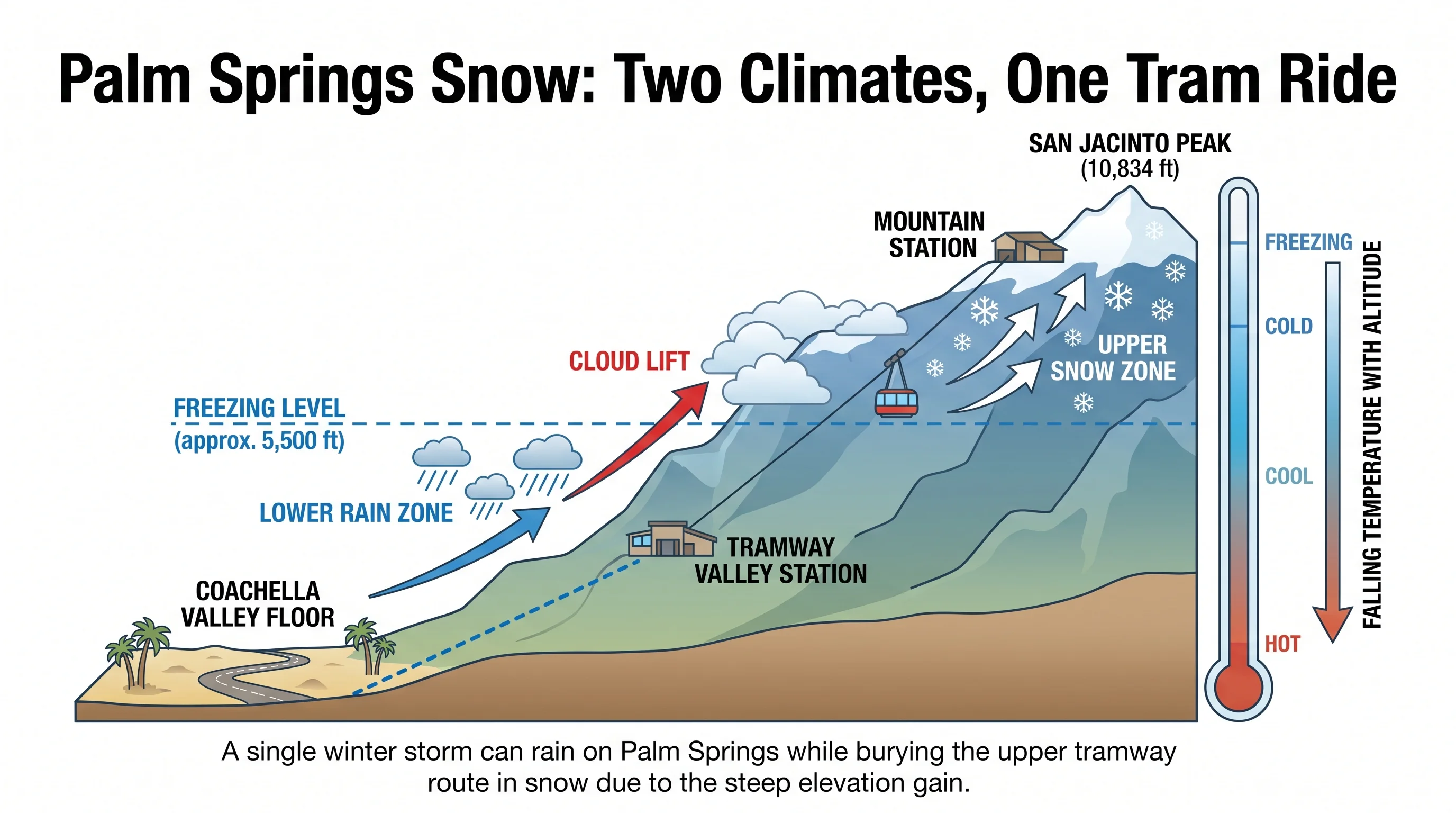
A vertical profile diagram rising from the Coachella Valley floor near Palm Springs through the Tramway Valley Station to the Mountain Station and San Jacinto Peak, labeling falling temperature, the freezing level, cloud lift along the mountain face, a lower rain zone, and an upper snow zone
Mount San Jacinto rises more than 10,000 feet directly above the Coachella Valley floor, so a single winter storm can rain on Palm Springs while burying the upper tramway route in snow.

When could flakes reach the Palm Springs floor?

It takes an unusual combination: a storm cold enough to push the snow level down near the valley floor, and enough remaining moisture in that cold air to actually produce precipitation rather than clear, dry skies. Southern California's coldest storms are often the driest ones by the time they reach the desert, since a deep, cold trough can strip much of the moisture out of the air mass before it arrives. When flakes have been reported at low elevation in the Coachella Valley, they have typically been light, brief, and mixed with rain rather than a sustained, accumulating snowfall.

It is also worth separating true snow from graupel, small soft pellets of rimed ice that form in cold-season showers and can briefly look like snow on car windshields and lawns before melting within minutes. Visible snow on the surrounding slopes above the valley, which happens somewhat more often than snow reaching the floor itself, is a different and much more common event than flakes actually landing in Palm Springs.

What does Palm Springs snow history show?

Documented snow reaching the low desert floor around Palm Springs is rare enough that any specific date or amount deserves scrutiny against official National Weather Service and NOAA climate normals records rather than being repeated from memory or social media. The verified pattern is the mountain side of the story: San Jacinto Peak and the upper tramway zone receive measurable winter snow in nearly every season, based on the 1991 to 2020 NOAA Climate Normals period, while the valley floor's own snow history consists mostly of scattered, lightly documented cold snaps rather than a recurring seasonal event.

That asymmetry, a well-established mountain snow record next to a thin and unreliable desert-floor record, is itself the honest answer to how often it snows in Palm Springs proper. Readers looking for a specific historic date for the valley floor should treat unverified local claims with caution and rely on NWS San Diego's official records instead.

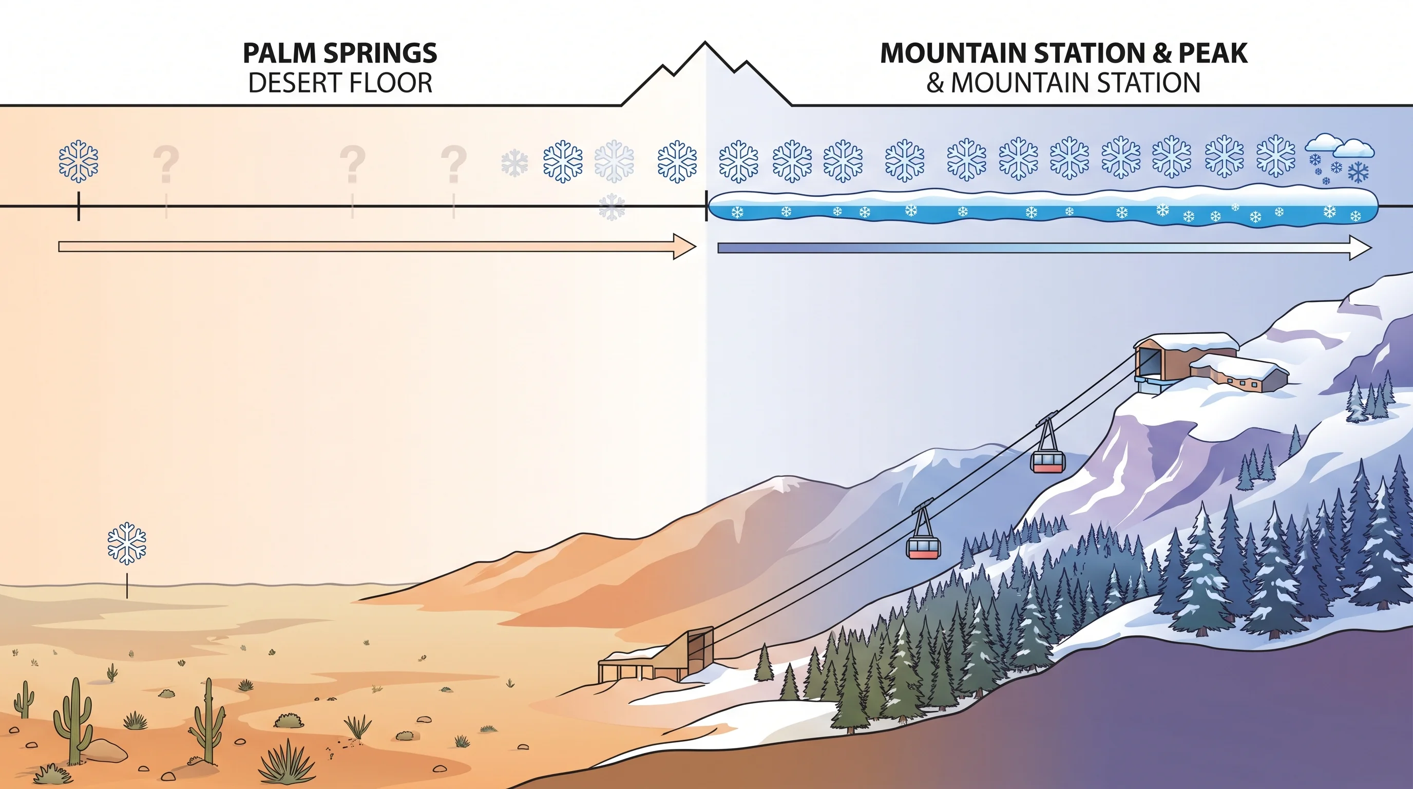
A timeline graphic comparing rare, lightly documented snow reports on the Palm Springs desert floor against a much denser record of routine winter snow accumulation at the Tramway Mountain Station and San Jacinto Peak
San Jacinto's upper elevations see reliable winter snow nearly every season, while confirmed snow on the Palm Springs valley floor is rare enough that individual reports are hard to verify.

Where can visitors find nearby winter snow?

The most accessible option is the upper reach of the Palm Springs Aerial Tramway, which carries visitors from the desert floor to roughly 8,516 feet near San Jacinto Peak, well within the elevation band that holds reliable winter snowpack most seasons. The tram is a genuine way to reach snow country in minutes rather than hours, but it is also weather-dependent: high wind, ice, or heavy snowfall can pause or slow operations, so its current operating status and reported summit conditions should be checked directly rather than assumed from a sunny day in the valley below.

Travelers who want a more conventional mountain trip can also look beyond the Coachella Valley to the San Bernardino Mountains, where Big Bear Lake, at roughly 6,750 feet, and Wrightwood, at around 6,000 feet, offer road-accessible winter snow and lift-served skiing most seasons. Each of those destinations has its own elevation, access road, and typical snow season, covered in more depth on does it snow in Big Bear Lake and in the wider regional picture at where does it snow in Southern California.

How should you plan for valley and mountain conditions?

Treat a trip that touches both the Coachella Valley floor and San Jacinto's upper elevations as two separate forecasts, not one. Check the point forecast for Palm Springs from NWS San Diego for valley conditions, then check the separate mountain point forecast and current tram status before heading up, since a mild, sunny desert afternoon can sit directly beneath a cold, windy, snow-showering mountain summit at the very same hour.

The temperature difference between the two elevations routinely exceeds 30 to 40°F, and wind that feels like a light desert breeze at the valley floor can be a sustained, biting gust at 8,000 feet, so pack layers even on a trip that starts in shorts weather. If the plan also involves driving rather than the tramway, such as a route toward the San Bernardino Mountains, check Caltrans QuickMap for chain controls and closures, and review NWS winter weather safety guidance if mountain driving in snow is unfamiliar. For the broader Los Angeles-area pattern behind this same elevation split, see does it snow in Los Angeles.

Palm Springs and San Jacinto are really two climates stacked on top of each other, a warm desert floor and a genuine alpine mountain, separated by a ten-minute tram ride and nearly 6,000 vertical feet. Before planning a day that spans both, check the current temperature and conditions for Palm Springs and the tramway's mountain station separately on WeatherEscape's Los Angeles forecast pages, so the shorts you packed for the desert do not end up being all you brought to the snow.

Frequently Asked Questions

Does it snow in Palm Springs?

On the desert floor, essentially never in a way that accumulates. Palm Springs sits at roughly 487 feet of elevation in the Coachella Valley, and the National Weather Service San Diego office has no pattern of routine measurable snowfall there. Winter storms typically bring cold rain and wind to the valley while the same system can bury nearby Mount San Jacinto in snow above about 6,000 to 7,000 feet.

How can one storm bring valley rain and mountain snow?

Mount San Jacinto rises more than 10,000 feet directly above the Coachella Valley floor within just a few miles, so a storm's snow level, the elevation above which precipitation falls as snow, cuts across that rise partway up. Below the snow level the storm lands as rain on the desert; above it, the same moisture falls as snow on the upper mountain, which is why Palm Springs can get soaked in cold rain while San Jacinto Peak gets buried at the same time.

When could flakes reach the Palm Springs floor?

It takes a storm cold enough to push the snow level down near the valley floor while still carrying enough moisture to produce precipitation, a combination that is uncommon in the desert. Southern California's coldest storms are often its driest by the time they reach the Coachella Valley, so when flakes have reached low elevation historically, they have generally been light and brief rather than a sustained, accumulating snowfall.

What does Palm Springs snow history show?

Confirmed snow reaching the low desert floor is rare enough that specific historical claims deserve verification against official National Weather Service and NOAA records rather than local retelling. The well-documented half of the story is the mountain: San Jacinto Peak and the tramway's upper elevations receive measurable winter snow in nearly every season based on NOAA's 1991 to 2020 Climate Normals, even though the valley floor's own snow record stays thin.

Where can visitors find nearby winter snow?

The Palm Springs Aerial Tramway is the fastest option, carrying visitors from the desert floor to roughly 8,516 feet near San Jacinto Peak in about ten minutes, well within the elevation band that holds reliable winter snowpack most seasons. Travelers who want a road trip instead can head to Big Bear Lake, at roughly 6,750 feet, or Wrightwood, at around 6,000 feet, both in the San Bernardino Mountains and both known for regular winter snow accumulation.

When was the last time it snowed in Palm Springs?

The exact date of the most recent confirmed low-elevation snow on the Palm Springs valley floor is not something this article states as a specific figure, because reliable public confirmation requires checking current National Weather Service San Diego office records rather than relying on secondhand reports. What is consistent year to year is that San Jacinto's upper slopes, including the tramway's Mountain Station, see snow in nearly every winter, even in years when the valley floor sees none at all.

How much colder is the top of the Palm Springs Aerial Tramway than the desert floor?

The temperature difference between the Coachella Valley floor and the Tramway Mountain Station commonly exceeds 30 to 40°F on the same day, since the ride climbs nearly 6,000 vertical feet in about ten minutes. Wind that feels like a light breeze in the desert can also be a sustained, biting gust at the 8,516-foot Mountain Station, so visitors should pack layers even when leaving the valley floor in shorts weather.

Related Destinations

Live Los Angeles Conditions

Compare temperature, wind, clouds, and comfort across the map.

See which microclimates are clear, cool, windy, smoky, or warming up right now.

Open the Weather Map
Destinations☀️Smog Forecast🌫️Smog Heat Map🔒Privacy Policy📄Terms of Service