climate sciencephenomenamicroclimatesrainfall

Rain Shadow: Palm Springs Dry, San Gabriels Soaked

By WeatherLA|Published |Last updated |10 min read
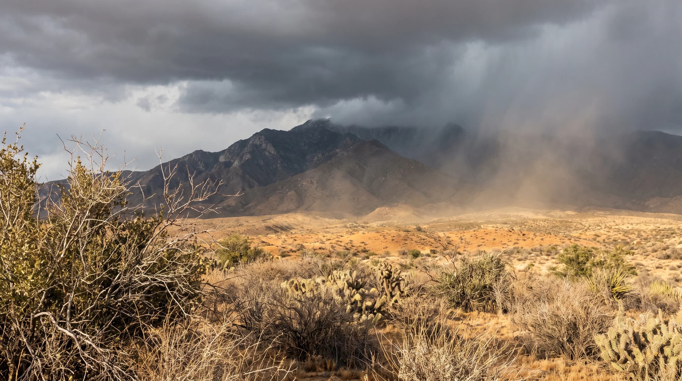
A single Pacific storm spanning wet windward mountain slopes, snow-capped high peaks, and sunlit dry desert terrain in the rain shadow east of the Southern California mountains

Key Takeaways

  • A rain shadow forms when a mountain range forces moist air to rise and drop its rain or snow on the windward slope, leaving descending air warmer and drier on the leeward slope.
  • The San Gabriel and San Bernardino Mountains create the rain shadow over the Antelope Valley and the western Mojave Desert, while the San Jacinto Mountains do the same for the Coachella Valley near Palm Springs.
  • Descending leeward air is not moisture-free; it simply holds far less relative humidity because it warms through compression, which is why desert storms often produce virga, rain that evaporates before reaching the ground, instead of measurable rainfall.
  • A rain shadow is a long-term precipitation pattern built storm after storm, which is different from a Santa Ana wind, a specific offshore wind event, and different from a temperature inversion, a vertical layering of air that traps pollution.
  • A single winter storm can produce ordinary rain in the Los Angeles Basin, heavy snow in the San Gabriel and San Bernardino high country, and only scattered virga in the desert, all from the same air mass.
  • Smaller local ranges like the Santa Monica Mountains and Simi Hills create their own scaled-down rain shadow effect over the San Fernando Valley, showing the mechanism applies to any sufficiently tall terrain, not just the largest named deserts.

A rain shadow is the dry zone that forms on the downwind side of a mountain range after the range has already forced moist air to rise, cool, and drop its rain or snow on the upwind slopes. In Southern California, Pacific storms moving inland hit the San Gabriel and San Bernardino Mountains first, wringing out most of their moisture on the western, ocean-facing slopes. By the time that air crosses the crest and sinks into the Antelope Valley, the Mojave Desert, and the Coachella Valley, it has already lost the bulk of its water and starts warming again as it descends, which is why the desert floor an hour east of downtown can be sunny and dry while the peaks above it are getting soaked.

What Is a Rain Shadow?

A rain shadow is a region of reduced precipitation that sits on the leeward, or downwind, side of a mountain barrier, paired with a wetter windward side that faces the incoming moisture. The terms come directly from the storm's approach direction: windward is the slope the wind and moisture hit first, leeward is the slope on the far side, in the shelter of the terrain. For Southern California, Pacific storms generally track in from the west and southwest, so the windward slopes of the Transverse Ranges face the ocean and the leeward slopes face the desert interior.

This is a geography term recognized by climate scientists worldwide, not a Southern California invention. The same mechanism explains why eastern Washington is drier than the Cascades' western slopes, and why Nevada sits in the rain shadow of the Sierra Nevada. Locally, the effect is easiest to see by comparing named stations directly across the mountain crest from each other, which is what the table below does.

Windward vs. Leeward: How Terrain Splits Southern California's Rainfall
LocationPosition relative to the mountainsGeneral climate character
PasadenaWindward foothill, against the San GabrielsWetter than the open basin, with orographic enhancement from nearby slopes
Downtown Los AngelesBasin floor, upwind of the main crestModerate seasonal rainfall, well short of the mountain peaks above it
Woodland HillsInland valley, partially sheltered by coastal terrainWarmer summer extremes than the coast, with its own local rainfall variation
Palm SpringsLeeward desert floor, east of the San Jacinto and San Bernardino crestOne of the driest, warmest climates in the region, sheltered from most Pacific storm moisture

How Does Rising Air Lose Moisture?

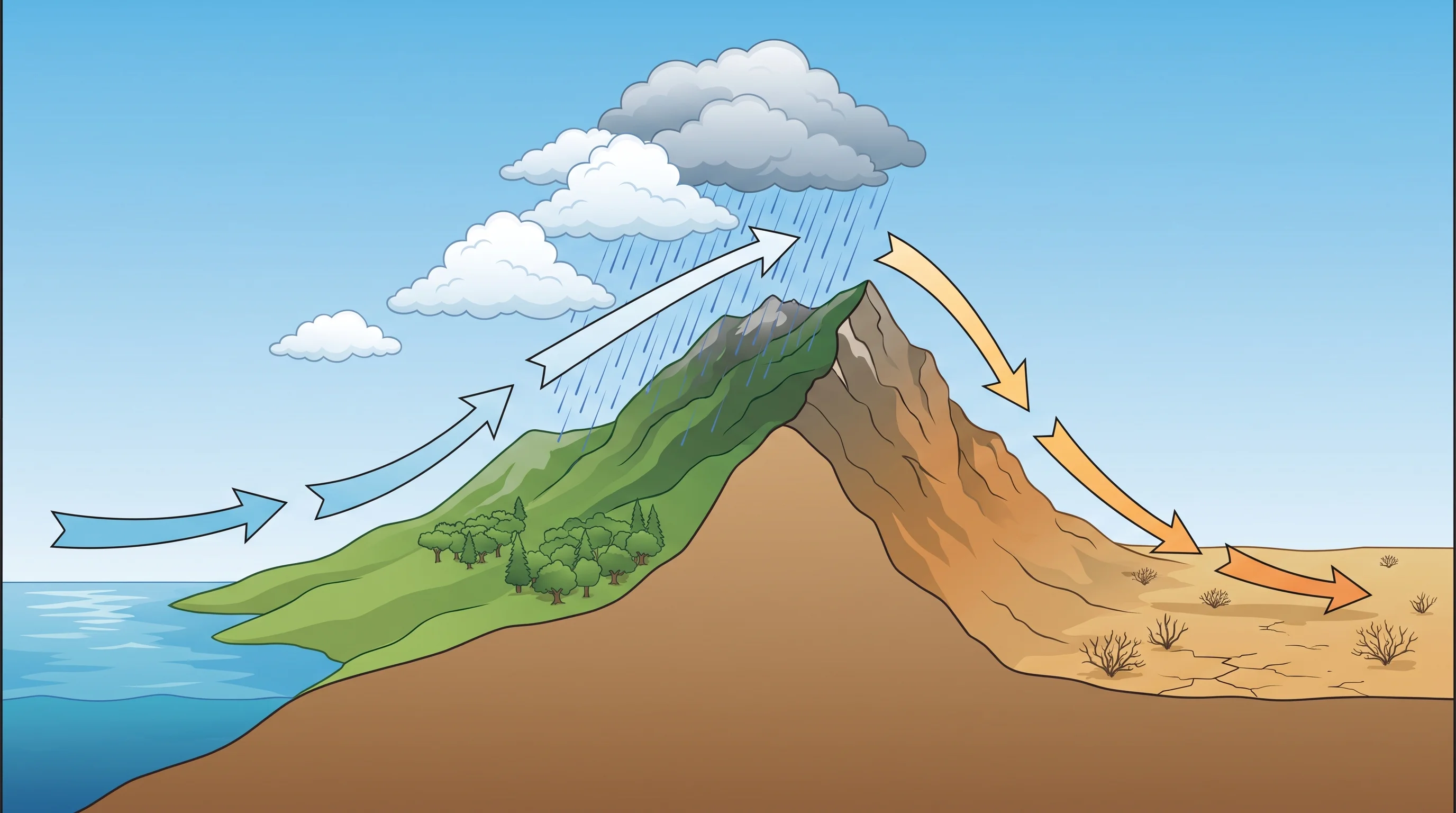
When a moist Pacific air mass runs into the San Gabriel or San Bernardino Mountains, it has nowhere to go but up, a process meteorologists call orographic lift. As that air climbs the windward slope it expands into the lower pressure of higher altitude, and expanding air cools. Once it cools enough, the water vapor it carries condenses into cloud droplets, and if the process continues, those droplets grow heavy enough to fall as rain or, at higher and colder elevations, as snow. The steeper and higher the terrain, the more thoroughly this process can wring moisture out of an approaching storm before the air ever reaches the crest.

The rate at which rising air cools depends on how much moisture it is carrying, a detail meteorologists track through the moist and dry adiabatic lapse rates described in Weather Prediction Center forecast discussions. Saturated air cools more slowly as it rises than dry air does, because condensation releases latent heat back into the air mass, but the net effect over a full climb up the San Gabriels is still a large cumulative loss of moisture by the time the air nears the crest. That is why the highest, steepest terrain along a storm's path tends to record the heaviest rain and snow totals in the region, while lower ridgelines let more moisture pass over relatively untouched.

This is the same rising-cools-condenses sequence covered in more general terms in how LA's mountains shape its weather, which walks through orographic lift as one piece of a broader look at heat, fog, and terrain across the county. This article stays focused on what happens next, once that air finishes its climb and starts back down the other side, and on why that downwind half of the story is what actually defines a rain shadow.

Why Does Descending Air Become Warmer and Drier?

Once air crosses the mountain crest and begins sinking down the leeward slope, the process that cooled it on the way up runs in reverse. Descending air moves into higher pressure near the surface, compresses, and warms. Because it already lost a large share of its moisture to precipitation on the windward climb, that same parcel of air arrives over the desert floor both warmer and considerably drier than it was when it first came ashore from the Pacific. Relative humidity drops sharply in this stage, not because the air lost every trace of water, but because warmer air can hold more moisture, so the same amount of water vapor represents a much lower percentage of what the air could carry.

That is the key distinction worth holding onto: a rain shadow does not mean the air is bone dry in an absolute sense, only that it has been depleted relative to what it started with and warmed enough that what moisture remains rarely condenses back out. This is why storms that reach the Antelope Valley or the Coachella Valley usually arrive as high cloud, wind, or a few scattered drops rather than sustained rain, even when the same system dumped inches of precipitation on the mountains just a few miles upwind.

Unlabeled windward-to-leeward process diagram showing moist Pacific air rising up a generic mountain slope, cooling into clouds and rain near the crest, then descending as warmer, drier air over a generic desert floor, without naming or depicting a specific Southern California city or mountain range
Keep this mechanism cross-section geographically generic and use no place names, so it does not falsely pair Palm Springs with the San Gabriel Mountains. The local map later in the article handles the distinct San Gabriel, San Bernardino, and San Jacinto rain shadows.

Which Ranges Shape Southern California Rain Shadows?

The San Gabriel and San Bernardino Mountains do most of the work for the deserts directly east and northeast of the Los Angeles Basin. Pacific moisture that survives the climb over these ranges is largely spent by the time it descends into the Antelope Valley on the northern side and the western Mojave Desert beyond it, both sitting in the shadow cast by the San Gabriels. Farther south, the San Jacinto Mountains perform the same function for the Coachella Valley, including Palm Springs, which sits close enough to the eastern base of the San Jacintos that it ranks among the driest, warmest inhabited valleys in the country even though it is barely 100 miles from the ocean.

The Sierra Nevada, well north of the Los Angeles Basin, does not directly shape these specific deserts, but it performs an even larger-scale version of the same process for the Owens Valley and the wider Great Basin, and it is worth naming because it is the textbook example most often cited alongside Southern California's own ranges in explanations of the rain shadow effect. Every one of these ranges works the same way: height and steepness relative to the prevailing storm track determine how much moisture gets extracted before the air ever reaches the desert side.

Local terrain complicates the pattern in useful ways rather than breaking it. Woodland Hills and the rest of the San Fernando Valley sit partly sheltered by the Santa Monica Mountains and the Simi Hills to the west, which is a separate, smaller-scale rain shadow effect layered on top of the larger San Gabriel pattern, and it is part of why valley rainfall and temperature extremes differ from both the coast and the open basin. The lesson generalizes: any range tall enough to force sustained lift, not just the largest named mountains, can produce a measurable dry zone on its lee side, even if that zone is a single valley rather than an entire desert.

Is a Rain Shadow a Santa Ana Wind?

No. A rain shadow is a long-term, storm-by-storm precipitation pattern created by terrain blocking moisture, while a Santa Ana wind is a specific, shorter offshore wind event driven by high pressure building over the Great Basin and pushing air downslope toward the coast, independent of whether a Pacific storm is even present. The two can share a downslope-warming mechanism, since Santa Ana winds also warm and dry through compression as they descend toward the coast, but a rain shadow describes where storms consistently drop less rain over years of records, not a single wind event measured in hours or days.

A rain shadow is also distinct from a temperature inversion, which is a vertical layering of warm air over cooler surface air that traps pollution in the basin rather than a horizontal difference in rainfall across a mountain range. That mechanism, including why it concentrates smog near the surface, is covered separately in temperature inversions and trapped smog. The related question of why some neighborhoods run hotter after dark, driven by pavement and building materials rather than terrain and moisture, is its own topic in the urban heat island effect in Los Angeles.
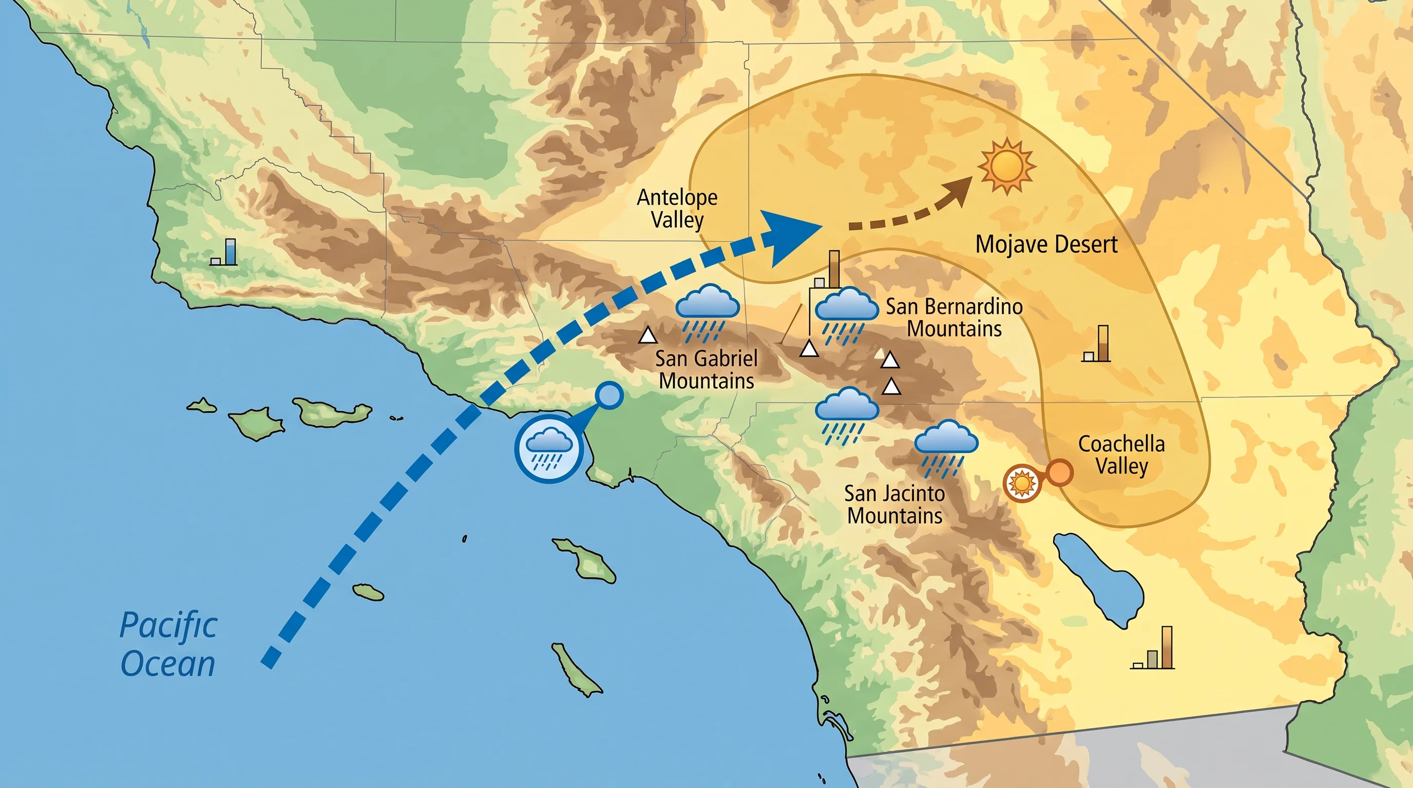
Regional map of Southern California aligning coastal, mountain, and desert stations with elevation labels, an arrow showing the prevailing west-to-southwest storm direction, and a shaded rain shadow zone over the Antelope Valley, Mojave Desert, and Coachella Valley
Coastal and mountain stations sit upwind of the San Gabriel, San Bernardino, and San Jacinto crest, while the Antelope Valley, Mojave Desert, and Coachella Valley sit downwind in the rain shadow the same storms leave behind.

How Can One Storm Produce Rain, Snow, and Desert Virga?

A single Pacific storm crossing Southern California can put on three different shows along one cross-section of terrain, all driven by the same air mass and the same physics. Near the coast and across the basin, the storm delivers ordinary rain. As that air is forced up the San Gabriel or San Bernardino slopes, cooling with elevation drops the freezing level, the altitude where temperature crosses 32°F, low enough that the same storm turns to snow above a few thousand feet, burying the high country while the basin below stays wet and merely cold.

Once the remaining air crosses the crest and descends toward the desert, what moisture is left may still form high cloud or even visible rain streaks called virga, but the warming, drying air beneath those clouds evaporates the precipitation before it ever reaches the ground.

Virga is a useful visual marker of a rain shadow in action: it shows a storm is still trying to produce rain, but the desert-side air mass has already become too warm and too dry for that rain to survive the trip down. Trackable through the same event, from the Weather Prediction Center's storm guidance to the snow level and precipitation totals issued by NWS Los Angeles/Oxnard and NWS San Diego, the same storm produces a fully documented range of outcomes, coastal rain, mountain snow, and desert virga, without any single number telling the whole story on its own.

Heavy windward-side rain carries its own hazards worth checking separately, particularly on steep or recently burned slopes, where the USGS Landslide Hazards Program and NWS flood safety guidance cover the debris flow and flash flood risk that can follow the same storms responsible for the mountain-desert rainfall split described here.

The rain shadow is not a one-time event but a durable pattern built storm after storm, year after year, by the same San Gabriel, San Bernardino, and San Jacinto terrain that gives coastal Los Angeles its rain and the deserts to the east their sun. Before planning a trip that crosses from the basin into the mountains or out toward the desert, compare current conditions, snow level, and forecast rain totals for each stop along the route on WeatherEscape rather than assuming one number for the whole drive.

Frequently Asked Questions

What is a rain shadow?

A rain shadow is a region of reduced rainfall on the leeward, or downwind, side of a mountain range, paired with a wetter windward side that faces the incoming storms directly. In Southern California, Pacific storms generally approach from the west and southwest, so the ocean-facing slopes of the San Gabriel, San Bernardino, and San Jacinto Mountains are windward, and the desert-facing slopes to the east are leeward.

How does rising air lose moisture?

When moist Pacific air is forced up a mountain slope, it expands into lower pressure at higher altitude and cools as it rises, a process called orographic lift. Once the air cools enough, its water vapor condenses into cloud droplets that grow heavy enough to fall as rain or, at colder, higher elevations, as snow, which is why the steepest, tallest terrain along a storm track tends to record the heaviest precipitation totals.

Why does descending air become warmer and drier?

Once air crosses a mountain crest and starts sinking down the far side, it moves into higher surface pressure and compresses, and compression warms it. Because that same air already lost much of its moisture climbing the windward slope, it arrives over the desert floor warmer and with much lower relative humidity, not because every trace of water is gone, but because warmer air can hold more moisture, so the remaining water vapor represents a smaller share of what the air could carry.

Which ranges shape Southern California rain shadows?

The San Gabriel and San Bernardino Mountains shape the rain shadow over the Antelope Valley and the western Mojave Desert northeast of the Los Angeles Basin. Farther south, the San Jacinto Mountains create the same effect over the Coachella Valley, including Palm Springs, which sits close enough to the range's eastern base to rank among the driest, warmest inhabited valleys in the country.

Is a rain shadow a Santa Ana wind?

No. A rain shadow is a long-term precipitation pattern built by terrain blocking moisture across many storms, while a Santa Ana wind is a specific, shorter offshore wind event driven by high pressure building over the Great Basin, and it can occur with no Pacific storm present at all. Both involve air warming and drying as it descends, but a rain shadow is measured in years of rainfall records, not hours of wind.

How can one storm produce rain, snow, and desert virga?

A single Pacific storm crossing Southern California delivers ordinary rain near the coast and across the basin, turns to snow above a few thousand feet in the San Gabriel and San Bernardino high country as the freezing level drops with elevation, and often produces only virga, or rain that evaporates before reaching the ground, once the remaining air descends into the desert's warmer, drier conditions. All three outcomes come from the same air mass moving across the same terrain.

Does a rain shadow mean the desert never gets rain?

No. The Antelope Valley, Mojave Desert, and Coachella Valley still receive rain, particularly from storms with unusually deep moisture or a track that allows some systems to reach the desert more directly, but their long-term totals stay far below the mountain and coastal averages because the rain shadow removes most of the moisture before typical storms arrive. Desert rainfall tends to be less frequent and more variable year to year than coastal or mountain rainfall.

Is a rain shadow the same as a temperature inversion?

No. A rain shadow is a horizontal difference in rainfall across a mountain range caused by moisture being removed on the windward side. A temperature inversion is a vertical layering of warmer air over cooler surface air that traps pollution near the ground, a separate mechanism covered in the Los Angeles temperature inversions article.

Related Destinations

Live Los Angeles Conditions

Compare temperature, wind, clouds, and comfort across the map.

See which microclimates are clear, cool, windy, smoky, or warming up right now.

Open the Weather Map
Destinations☀️Smog Forecast🌫️Smog Heat Map🔒Privacy Policy📄Terms of Service