floodingsafetysevere weathertrip planning

Why Joshua Tree Floods Fast: Hardpan, Slot Canyons

By WeatherLA|Published |Last updated |8 min read
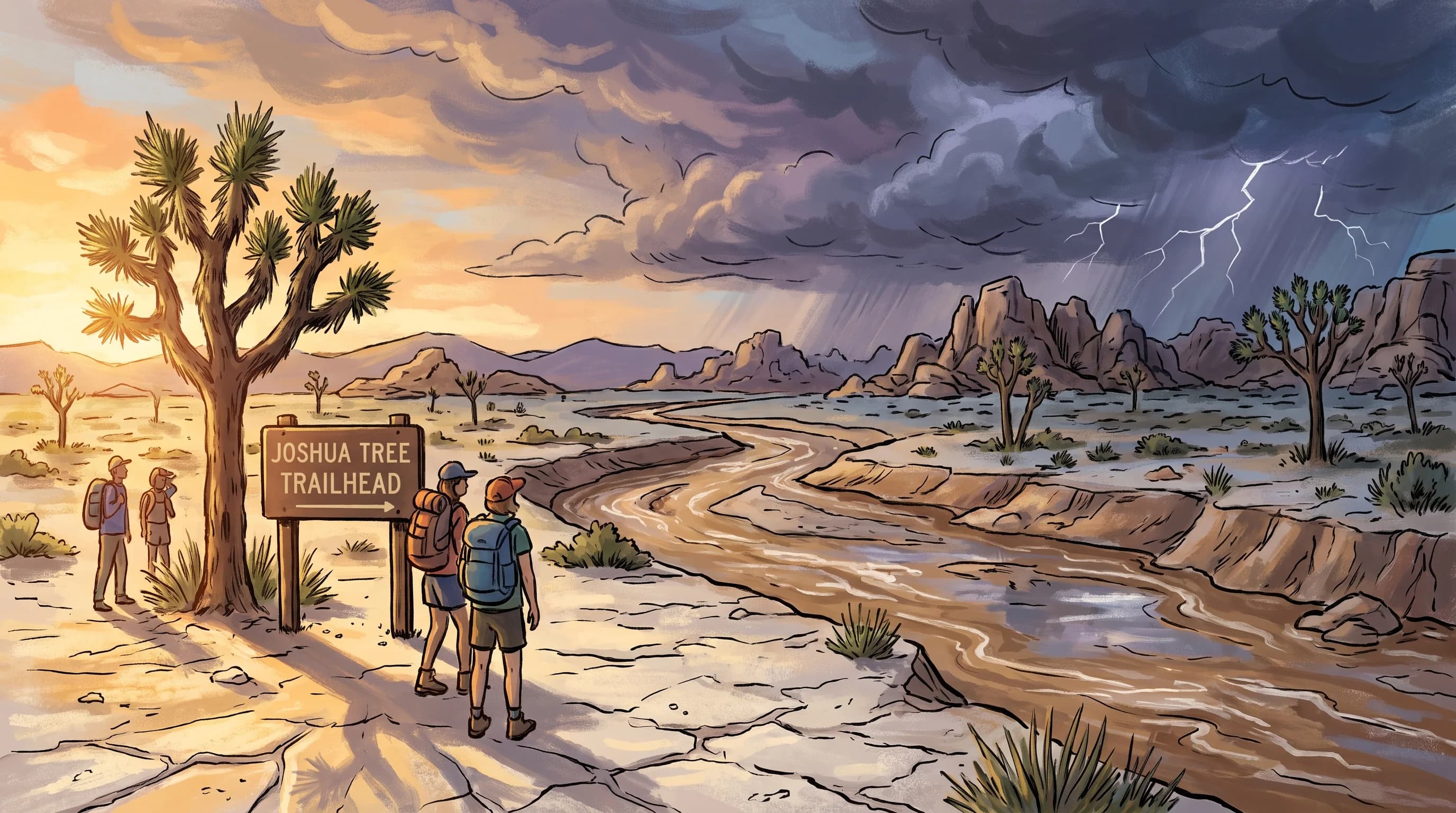
A Joshua Tree desert wash beginning to carry muddy runoff beneath distant thunderclouds while the immediate trailhead remains partly sunlit

Key Takeaways

  • Joshua Tree floods fast because much of the park sits on bare granite and caliche, a cemented hardpan soil crust that sheds rain almost like pavement instead of absorbing it.
  • A wash can flood with no rain falling at the hiker's own location, since the water often comes from a monsoon thunderstorm cell sitting over a canyon or ridge miles upstream and out of sight.
  • The North American Monsoon, roughly July through September, produces the park's most localized and least-warned flash floods, while broader winter storms soak more ground at once but are typically easier for NWS to forecast.
  • Much of Joshua Tree National Park has no reliable cell signal, so visitors cannot count on a phone alert reaching them in a backcountry wash or slot canyon the way it might in town.
  • Slot canyons, canyon mouths, low-water road dips, and campsites pitched inside or beside a wash bed are the park's highest-caution terrain, according to National Park Service guidance.
  • The same Turn Around Don't Drown rule used nationwide applies in Joshua Tree: never enter a flowing wash on foot or by vehicle, since depth and current are both impossible to judge accurately by eye.

Joshua Tree National Park can flood fast because its hardpan desert soil barely absorbs water, so a thunderstorm miles away sends runoff straight into dry washes and slot canyons within minutes, often with no rain falling where a hiker is standing. Add in remote trails with weak or absent cell signal, and the danger is less about the storm itself and more about people caught in a narrow canyon with almost no warning and no easy way to call for help. That combination, caliche-hardened ground, monsoon-fed washes, and backcountry isolation, makes Joshua Tree a different kind of flash flood risk than the paved washes of nearby Palm Springs.

Why can a desert downpour flood Joshua Tree in minutes?

A downpour can flood Joshua Tree in minutes because the ground itself is built to shed water, not absorb it. Much of the park sits on exposed granite, bare rock outcrops, and a hardened soil crust known as caliche or hardpan, a cemented layer of calcium carbonate that forms in arid climates and behaves almost like pavement once rain hits it. Where thin desert soil does exist, it is often compacted and has little organic matter or vegetation to slow water down, so the first heavy burst of a storm generates runoff almost immediately instead of soaking in gradually the way it would in a forested watershed.

This matters because the broader Mojave Desert looks and feels dry even during an active storm. A visitor standing at a trailhead can see clear sky, dry sand, and no obvious sign that anything dangerous is happening, while a thunderstorm cell dumping heavy rain over a ridge a few miles upcanyon is already generating a fast pulse of runoff. The National Weather Service Los Angeles/Oxnard office and the National Weather Service San Diego office both cover parts of the park's high desert terrain and issue Flash Flood Warnings based on rainfall rate and watershed response, not on how the sky looks from any single point on the ground.

Joshua Tree Wash vs. Urban Wash: How Much Warning You Get
SettingTypical runoff lagWhat usually limits warning time
Joshua Tree backcountry wash or slot canyonMinutes, sometimes under 15No cell signal, no sirens, and rain often falling out of sight upcanyon
Palm Springs or Coachella Valley wash crossingRoughly 30 to 60 minutesFaster if drivers ignore posted closures, but NWS warnings and local road closure alerts typically reach the area first
Paved Los Angeles street or underpassUnder an hourStorm drains and channels are engineered but can still be overwhelmed by intense rain rates

How do washes connect distant rain to roads and campsites?

Washes connect distant rain to roads and campsites by acting as the park's entire drainage system, funneling runoff from miles of upstream rock and ridge into a single low channel that a trail, dirt road, or campsite may cross or sit directly inside. Joshua Tree's watersheds drain from higher terrain in the north and east down through canyons and alluvial fans toward the lower desert basins, and a wash that has been bone dry for months can carry a genuine flood pulse once a storm cell sits over its upper reaches.

Blue sky overhead does not mean a wash is safe. Because monsoon thunderstorms are often small and short-lived, someone hiking or camped along a wash near Hidden Valley or the canyons below Keys View can be in direct sun while rain several miles upcanyon is already draining toward them. The National Park Service warns visitors that a dry wash can flood with no local rainfall at all, which is the single hardest part of this hazard for first-time desert visitors to internalize: the storm you need to worry about may not be one you can see or feel.

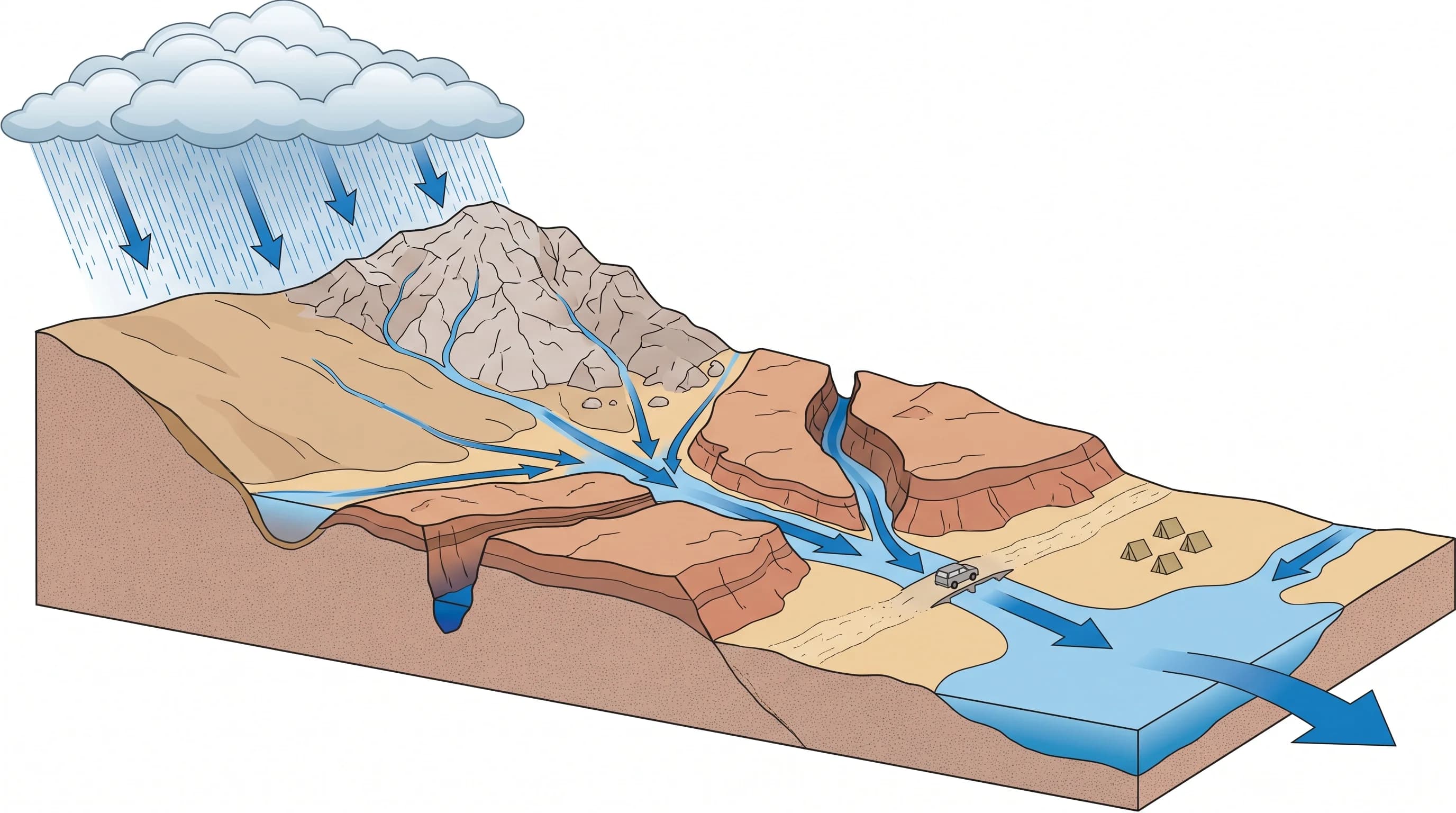
A rocky desert watershed diagram tracing an upstream cloudburst across impermeable rock into converging washes, low crossings, canyon camps, and downstream flats
Rain falling on bare granite and hardpan soil upcanyon in Joshua Tree reaches washes, low crossings, and campsites far downstream, often before any rain falls at those locations.

Are monsoon cells or winter storms more dangerous?

Neither season is universally more dangerous; monsoon cells and winter storms threaten Joshua Tree in different ways. The North American Monsoon typically brings isolated, intense thunderstorm cells to the Southern California deserts from roughly July through September, and a single cell can drop a heavy burst of rain on one canyon while a trailhead just a few miles away stays completely dry. That localized intensity is exactly what produces the fastest, least-warned flash floods in the park, because a hiker's own location can look and feel unthreatened right up until the water arrives.

Winter storms behave differently. Cool-season systems moving through Southern California tend to cover far more ground at once, soaking multiple washes and drainages across the park over several hours rather than one canyon in twenty minutes. They are generally easier for the NWS to forecast and warn on with more lead time, but they can still saturate ground, raise multiple washes simultaneously, and close remote dirt roads for longer stretches. Visitors should treat both patterns seriously rather than assuming the typically drier winter storm is automatically the safer one to be hiking through.

Which park landscapes demand extra caution?

Signed wash crossings, low-water dirt road dips, canyon mouths, and campsites tucked below steep catchments demand the most caution in Joshua Tree. The National Park Service signs and maintains several dip crossings on park roads specifically because they are known to flood during storms, and these low points can go from dry to impassable faster than a vehicle can safely turn around once water is visibly moving across them.

Slot canyons and narrow canyon mouths are the most dangerous terrain for hikers, since they concentrate runoff into a confined space with steep walls and few, if any, exit points partway through. A backcountry campsite pitched in or immediately beside a wash bed, which can look like the flattest and most sheltered spot available, sits directly in the path any flood will take. The safest practice recommended by park rangers is to camp and hike on higher ground well above the wash channel itself, not simply nearby it, and to treat any confined canyon as a place to move through quickly during monsoon season rather than linger in.

What warning signs can appear before the water?

The clearest warning signs before a flash flood are distant thunder, a sudden change in a wash's sound or the color of any water already present, floating debris, and a rise in water level even when it is not raining at your location. Thunder rumbling from a ridge you cannot see past is a signal to start moving to higher ground immediately, not a cue to wait and watch how the sky develops. A wash that suddenly starts running muddy, or that begins carrying sticks, leaves, or foam, is telling you that water is already on its way from upstream.

The hardest scenario is at night or in Joshua Tree's many backcountry sites with no cell coverage, where a hiker or camper may get no visible or audible warning at all before water arrives. Because so much of the park sits outside reliable cell service, checking conditions before you leave and telling someone your planned route and return time matter more here than in almost any other Southern California destination covered on this site. The National Park Service and NWS cannot push a phone alert to a canyon with no signal, so the responsibility shifts to advance planning rather than real-time notification.

When should a visitor turn around or move uphill?

A visitor should turn around or move to higher ground the moment a wash shows any flowing water at all, regardless of depth, and should never attempt to cross a flowing wash on foot or by vehicle. This mirrors the National Weather Service's Turn Around Don't Drown guidance used across the country: moving water is far more powerful than it looks, and both depth and current are nearly impossible to judge accurately by eye, especially in a muddy desert flow moving over uneven rock.

Before entering the park during storm season, check for an active Flash Flood Warning from NWS Los Angeles/Oxnard or NWS San Diego depending on which part of the park your route crosses, review current radar centered on the park's higher terrain rather than the trailhead itself, and check the National Park Service's Joshua Tree conditions page for road closures. If a route to Black Rock or a backcountry trailhead crosses a dip or wash, plan an alternative in case that crossing is closed when you arrive, and let a specific person know your planned hike and expected return time given how little cell coverage exists inside the park.

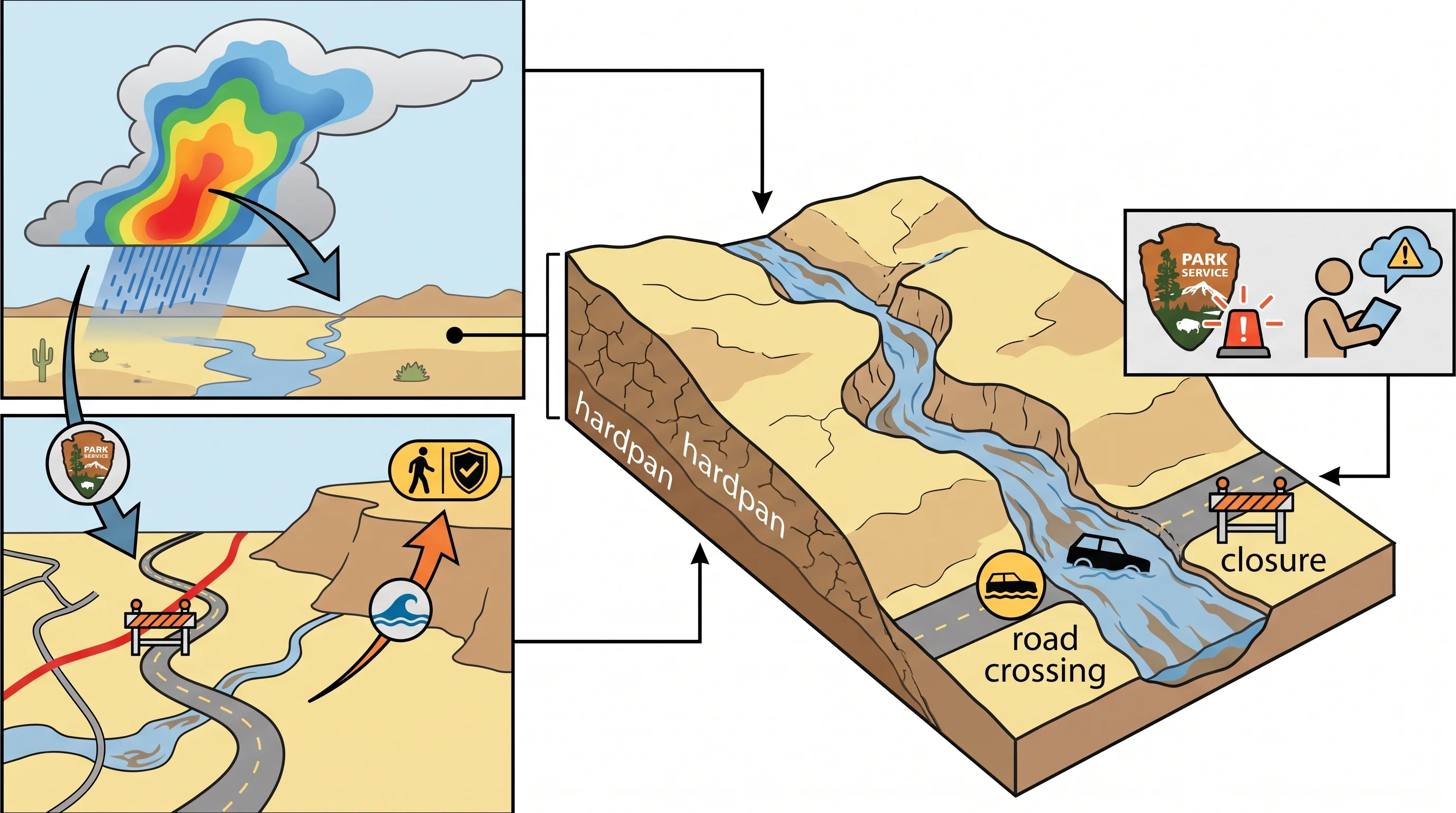
A park decision map pairing upstream radar cells, signed wash crossings, road closures, higher-ground escape points, and National Park Service alerts
Before entering Joshua Tree during storm season, check upstream radar, NWS warnings, and National Park Service road closures rather than the sky over the trailhead.

Joshua Tree's flash flood risk is really a story about ground that will not absorb water and distance that will not carry a warning. The same hardpan and bare rock that give the park its stark, photogenic landscape are also why a monsoon cell over a ridge you cannot see can fill a wash below your boots in minutes, and the same remoteness that makes the park feel wild also means no siren, alert, or ranger is guaranteed to reach you first.

This is a different hazard profile than the wash crossings of Palm Springs down the mountain, where roads and warning infrastructure sit much closer at hand; see flash flooding in Palm Springs for that comparison. Before hiking or camping in Joshua Tree during monsoon season or a winter storm, check WeatherEscape's Joshua Tree forecast alongside current NWS warnings and National Park Service road conditions, and treat any thunder, muddy water, or rising wash as a reason to head for higher ground immediately. The companion guides to Southern California monsoon storms and flood versus flash flood explain the larger weather pattern and warning terminology.

Frequently Asked Questions

Why can a desert downpour flood Joshua Tree in minutes?

Much of Joshua Tree National Park sits on exposed granite and caliche, a hardened, cemented soil crust common in arid climates that sheds rainfall almost like pavement instead of absorbing it. With little vegetation or soil structure to slow water down, a heavy monsoon or winter downpour generates fast runoff almost immediately, and that runoff concentrates into washes and slot canyons within minutes of the rain starting upstream.

How do washes connect distant rain to roads and campsites?

Washes act as the park's drainage system, channeling runoff from miles of upstream rock and canyon into a single low path that trails, dirt roads, and campsites often cross or sit inside. Because Joshua Tree's storms are frequently small and localized, a wash can rise with no rain falling at the hiker's own location, since the water is arriving from a cell that formed over a canyon or ridge out of sight.

Are monsoon cells or winter storms more dangerous?

Neither is universally worse; they threaten the park differently. Monsoon thunderstorm cells, common roughly from July through September, are isolated and intense, capable of flooding one canyon while a trailhead a few miles away stays dry, which makes them the hardest pattern to see coming. Winter storms cover more ground at once and are generally easier for the National Weather Service to forecast with lead time, but they can still saturate soil and raise multiple washes across the park in the same afternoon.

Which park landscapes demand extra caution?

Signed wash crossings and low-water road dips, narrow canyon mouths, slot canyons, and campsites pitched in or beside a wash bed all demand extra caution. The National Park Service specifically signs several road dips that are known to flood, and slot canyons concentrate runoff into confined spaces with steep walls and few exit points, making them the most dangerous terrain for a hiker caught by rising water.

What warning signs can appear before the water?

Distant thunder, a sudden change in a wash's water color or sound, floating debris such as sticks or foam, and a rising water level with no local rainfall are all warning signs that water is already on its way from upstream. At night or in the park's many areas without cell coverage, a hiker may get no warning at all before water arrives, which is why advance planning matters more here than real-time alerts.

When should a visitor turn around or move uphill?

A visitor should move to higher ground the moment any water is seen flowing in a wash, regardless of depth, and should never attempt to cross a flowing wash on foot or by vehicle. This follows the National Weather Service's Turn Around Don't Drown guidance, since both depth and current are nearly impossible to judge accurately by eye in a muddy desert flow.

Can a dry wash in Joshua Tree flood when it is not raining at the trailhead?

Yes. Because monsoon thunderstorm cells are often small and short-lived, a wash can flood from rain falling several miles upcanyon while the trailhead itself stays sunny and dry. The National Park Service warns that a dry-looking wash bed is not proof of safety, since the storm generating the flood may not be visible or audible from a hiker's exact location.

Why do arroyos, washes, and alluvial fans around Joshua Tree flood so quickly?

Arroyos and washes flood quickly because they are dry channels shaped by infrequent, powerful flows, sitting downstream of steep, largely bare rock terrain that sheds water far faster than the desert floor can absorb it. With minimal soil and vegetation to slow the flow and a significant elevation drop concentrated over a short distance in many park canyons, a channel that has been dry for months can carry a dangerous pulse of water within minutes of intense rain falling upstream.

Does Joshua Tree flood the same way Palm Springs does?

The basic mechanism, intense rain overwhelming ground that cannot absorb it, is similar, but the risk profile differs. Palm Springs sits in a developed valley where roads, warning infrastructure, and cell coverage are close at hand even when a wash crossing floods, while Joshua Tree's backcountry washes and slot canyons are remote, often without cell signal, and rely on visitors checking conditions and turning around on their own rather than receiving a real-time alert.

Related Destinations

Live Los Angeles Conditions

Compare temperature, wind, clouds, and comfort across the map.

See which microclimates are clear, cool, windy, smoky, or warming up right now.

Open the Weather Map
Destinations☀️Smog Forecast🌫️Smog Heat Map🔒Privacy Policy📄Terms of Service