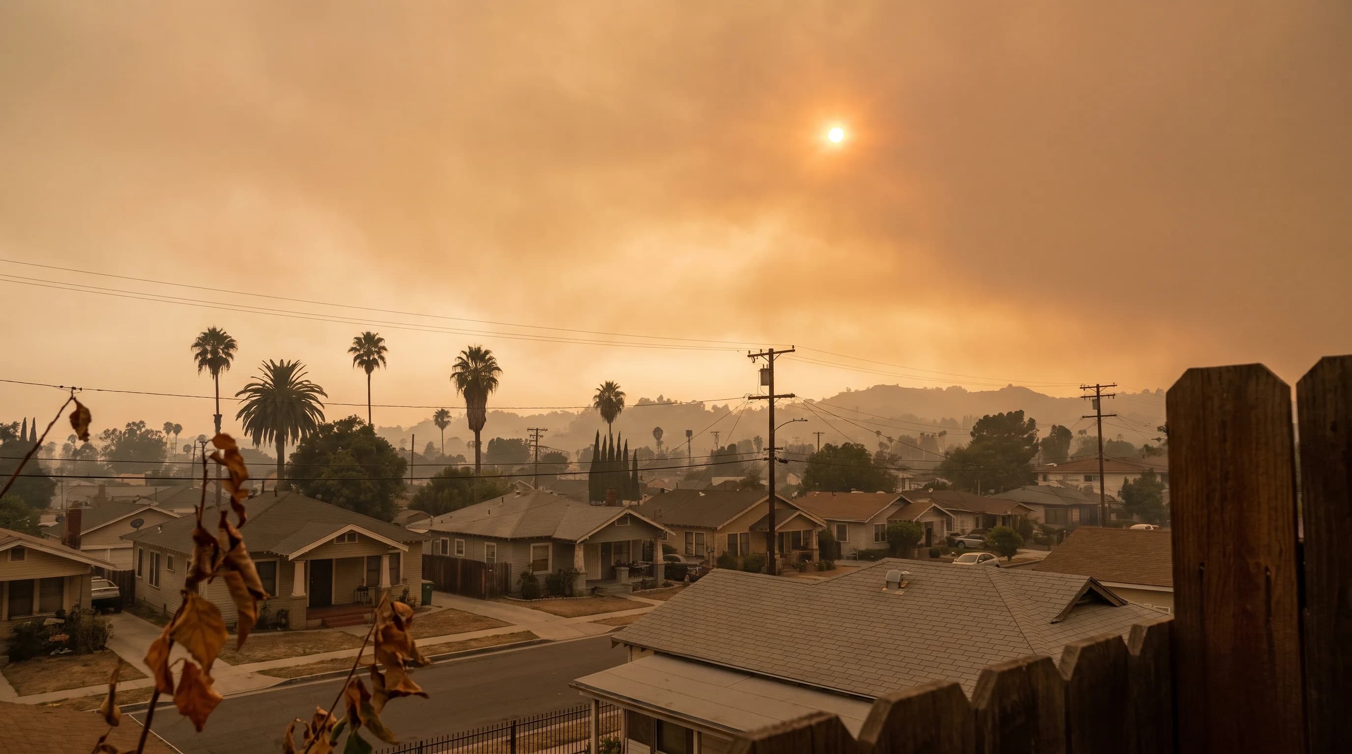
Wildfire smoke turns the Los Angeles sky orange because smoke particles scatter short blue and violet wavelengths of sunlight much more than long red and orange wavelengths. Blue light scatters away before it reaches your eye, while red and orange light passes through the smoke, so the sky and sun shift toward warm colors. An orange sky can happen even when smoke sits thousands of feet overhead. An orange sky over Downtown Los Angeles therefore does not tell you whether the air at ground level is safe to breathe.
Why Can Wildfire Smoke Turn the Sky Orange?
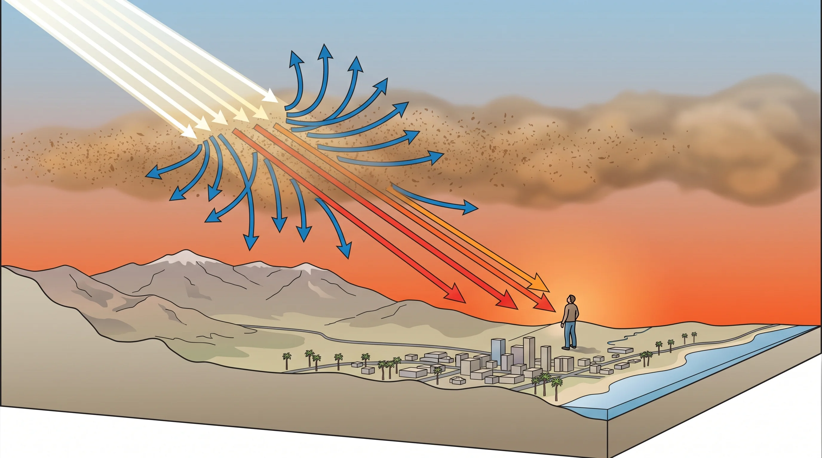
Sunlight looks white but contains every visible wavelength, from short blue and violet to long red and orange. When light hits particles in the air, the size of the particles compared with the wavelength decides how much scatters and where. Wildfire smoke is full of fine particles, mostly soot and organic particles in the PM2.5 size range. Those particles scatter and absorb short blue wavelengths far more than long red and orange ones.
On a clear day, the sky looks blue because air molecules, much smaller than smoke particles, scatter blue light, a process called Rayleigh scattering. In thick smoke, a different, size-dependent process called Mie scattering takes over and strips blue light from the sunbeam faster than red light. By the time sunlight passes through enough smoke to reach the Los Angeles Basin, the remaining light is shifted toward red, and the sky can turn orange, amber or copper. To tell wildfire smoke from smog and fog, see smog vs. smoke vs. fog.
| Smoke condition | Typical sky appearance | What is happening optically |
|---|---|---|
| Thin, distant, or high-altitude haze | Milky white to pale gray sky, dulled blue | Light particle load scatters some blue light out of view without removing enough to shift the dominant color toward red |
| Moderate regional smoke layer | Yellow to orange sky, muted or tinted sun | Enough particles to scatter most blue and green wavelengths out of the direct path, leaving yellow-orange light dominant |
| Dense smoke near an active fire | Deep orange to red-brown sky, dim red sun or sun not visible | Very high particle concentration absorbs and scatters most visible wavelengths, letting only the longest red wavelengths through in force |
| Thick, low, close-range smoke plume | Dark orange-gray daytime sky, sometimes described as premature dusk | Particle concentration is high enough to absorb a large share of all wavelengths, cutting overall light while still favoring red |
Why Does the Sun Look Red Through Smoke?
The sun looks red through smoke because its light travels a long, direct path through the smoke layer, and that path grows longer near sunrise and sunset. A low sun's light passes through a much thicker slice of atmosphere, including the smoke, than a midday sun's. A low sun and a smoky path together scatter away nearly all blue, green and yellow light, leaving a sun that looks deep red, copper or sometimes magenta.
Smoke thickness and particle size matter. A thin, high smoke layer may only dim the sun to a dull orange disk. A towering smoke plume can grow into one of the pyrocumulus clouds that large fires create.
A thick plume from a nearby fire can turn the sun blood red or hide it entirely. Ordinary orange and red sunsets on clear days come from the same physics; smoke intensifies it. The National Weather Service Los Angeles/Oxnard office, which covers the LA Basin, and the NWS San Diego office both note this effect when smoke moves through.
Can an Orange Sky Occur With Cleaner Surface Air?
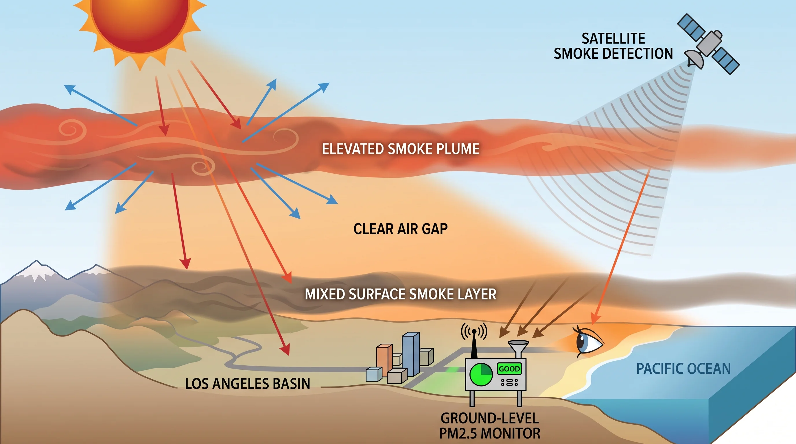
An orange sky can occur with clean air at the ground, and that distinction matters most for Los Angeles residents. Wildfire smoke often travels in a raised layer thousands of feet up, carried by upper-level winds far from the fire. Your eye sees the whole column of air between you and the sun. A plume aloft can paint the sky orange while the air at street level in Pasadena or Woodland Hills stays moderate on a ground monitor.
The reverse also happens. Smoke that has sunk to the ground, especially under a temperature inversion, can push PM2.5 to unhealthy levels while the sky looks only mildly hazy, because the smoke sits in a shallow layer instead of a deep one that scatters sunlight. Telling a raised plume from ground-level smoke takes a monitor reading and a smoke map, not a look out the window.
How Is Smoke Color Different From Smog, Dust, or a Normal Sunset?
Smoke, smog, dust and sunsets all color the sky through light scattering, but the particles differ and so do the colors. Photochemical smog forms from ozone and particles when sunlight acts on vehicle emissions for hours, as what is smog and how LA's photochemical haze forms explains. Smog usually makes a grayish-brown or yellow-brown haze low over the basin, not a saturated orange sky. For why smog often peaks inland on hot afternoons, see ground-level ozone in Southern California.
Windblown dust, common during Santa Ana winds, scatters light too, but its larger mineral particles make a tan or yellowish-brown sky, not deep orange or red. A clean-air sunset gets its warm colors from the long path of low sunlight through the air, without extra particles, and rarely becomes the vivid orange of a smoky sky. In Los Angeles, appearance alone cannot reliably tell these causes apart. A monitor reading, fire report or official wind advisory identifies the cause.
Can Sky Color Tell You if the Air Is Safe?
Sky color cannot tell you if the air is safe. Sky color reflects the whole column of air between you and the sun, including smoke miles overhead that never reaches the ground. Health guidance depends on fine particles at breathing level. A dramatic orange sky can come with acceptable air at the ground, and an ordinary hazy sky can come with unhealthy smoke, especially under an inversion that traps smoke low.
PM2.5, fine particles 2.5 micrometers or smaller that reach deep into the lungs, drives most wildfire smoke health guidance; see PM2.5 explained: the fine particles behind LA wildfire smoke AQI.
To judge whether it is safe to be outside during smoke, check a timestamped, ground-level PM2.5 reading and its Air Quality Index category, not the sky. The NWS wildfire safety guidance makes the same point: visible smoke and sky color are cues to pay attention, not substitutes for an air quality reading before exercising outdoors or opening windows.
Which Current Maps Should You Check?
Start with AirNow.gov, the federal real-time source for PM2.5 and AQI at stations across the Los Angeles area. Note each station's location and timestamp, because readings can change within an hour as wind and smoke shift. South Coast AQMD publishes air quality forecasts and smoke advisories for the LA Basin, and the California Air Resources Board adds statewide context during major smoke events.
To see where the smoke is and whether it is aloft or at the ground, check NOAA satellite smoke products, which show a plume's extent and estimated height. CAL FIRE tracks the active fires that may be the source. Check whether a map shows modeled or observed data, and whether it shows ground level or a higher layer. Confusing the two turns a harmless plume aloft into a false emergency, or the reverse.
An orange sky over the San Gabriel Valley or the LA Basin is a real optical effect, fully explained by how smoke particles scatter sunlight. It cannot replace an air quality reading. Before running outdoors, opening windows or keeping children inside during smoke, check AirNow.gov or South Coast AQMD for a current, timestamped PM2.5 reading near you. Check WeatherLA's Los Angeles forecast pages for wind direction and timing that show whether smoke will clear or linger.