climate scienceseasonalmicroclimatescity guide

Mediterranean Climate: Why LA Has Dry Summers

By WeatherLA|Published |Last updated |10 min read
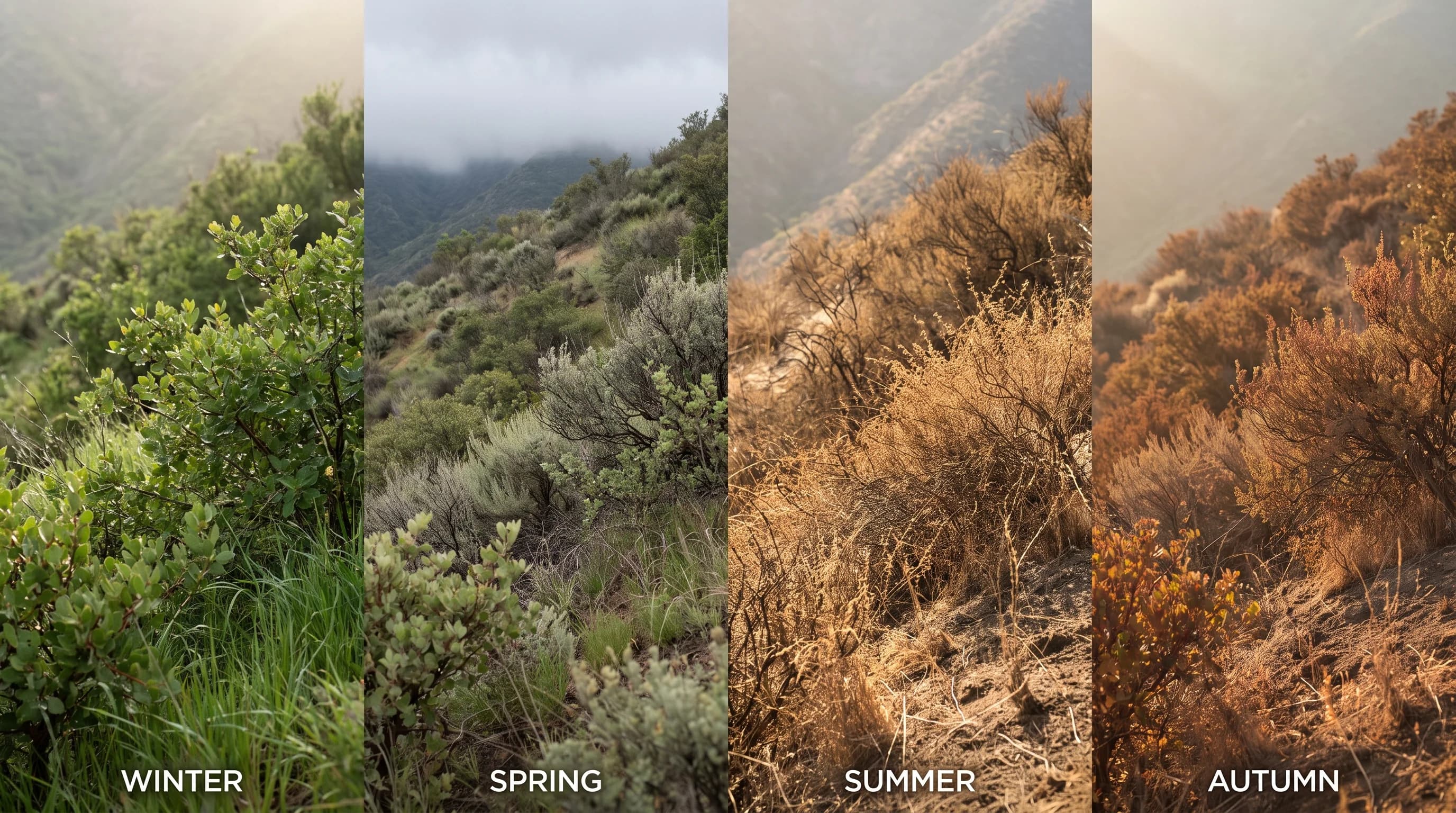
A four-season Los Angeles landscape showing green winter hillsides, spring marine cloud along the coast, a dry sunlit summer basin, and warm autumn light over the city

Key Takeaways

  • Los Angeles has a Mediterranean climate: dry, warm summers and mild, wetter winters, driven by the seasonal rise and fall of the eastern Pacific subtropical high.
  • The same high pressure system that blocks summer storms also caps the coastal marine layer, which is why fog and inland heat can happen on the same July day.
  • From roughly November through March, the subtropical high weakens and the jet stream dips south, opening the door for the Pacific storms and atmospheric rivers that supply most of the year's rain.
  • Los Angeles shares this seasonal structure with central Chile, South Africa's Western Cape, southwestern Australia, and the Mediterranean Basin, each shifted by hemisphere but built from the same mechanism.
  • Coastal fog, valley heat, and foothill wind are local variations of the same regional climate, shaped by distance from the ocean, elevation, and terrain rather than separate climate types.
  • California climate assessments show hotter extremes and more concentrated winter rainfall, but no assessment projects the region's dry-summer, wet-winter structure disappearing outright.

A Mediterranean climate is a seasonal rainfall pattern defined by dry, warm-to-hot summers and mild, wetter winters, driven by a subtropical high pressure system that shifts position through the year. Los Angeles has this climate type because the eastern Pacific high strengthens and moves north in summer, blocking storms, then weakens and slides south in winter, opening the door to Pacific storm systems. That single mechanism, not a lack of weather or an unusually mild location, explains why Downtown Los Angeles gets the vast majority of its annual rain between November and March and almost none of it in July or August.

What Is a Mediterranean Climate?

A Mediterranean climate is a seasonal pattern, classified as Csa or Csb in the Köppen climate system, marked by a pronounced dry season that coincides with summer and a wet season concentrated in winter. The defining feature is not simply mild temperatures; it is the timing of precipitation relative to temperature. In a Mediterranean climate, the warmest months of the year are also the driest, while the coolest months carry most of the annual rainfall. That inversion is unusual globally. Most of the world's rainy regions get their wettest weather when it is warmest, since warm air holds more moisture and drives more convective storms. Los Angeles does the opposite.

The climate type takes its name from the Mediterranean Basin, where the pattern was first described, but it appears on five separate continents wherever a similar set of ingredients lines up: a west-facing coastline near roughly 30 to 45 degrees latitude, a cold ocean current offshore, and a seasonally shifting subtropical high pressure belt. Southern California checks every one of those boxes, which is why Los Angeles, not just the Mediterranean coast of Europe, is one of the standard textbook examples of the climate type.

Five Mediterranean-Climate Regions: Same Seasonal Pattern, Different Continents
RegionApproximate latitudeDriest seasonWettest season
Los Angeles Basin, CaliforniaAbout 34°NSummer (June to September)Winter (November to March)
Central Chile (Santiago region)About 33°SSummer (December to February)Winter (May to August)
Western Cape, South AfricaAbout 34°SSummer (December to February)Winter (June to August)
Southwestern Australia (Perth region)About 32°SSummer (December to February)Winter (June to August)
Mediterranean Basin (southern Spain, Italy, Greece)About 36 to 42°NSummer (June to August)Winter (October to March)

Notice the pattern holds across both hemispheres. Regions in the Southern Hemisphere have their dry season in December through February because that is their local summer, while Los Angeles and the Mediterranean Basin, both in the Northern Hemisphere, are dry in June through August. The calendar months differ, but the underlying rule, dry in the warm season and wet in the cool season, is identical everywhere the climate type occurs.

Why Are Los Angeles Summers Dry?

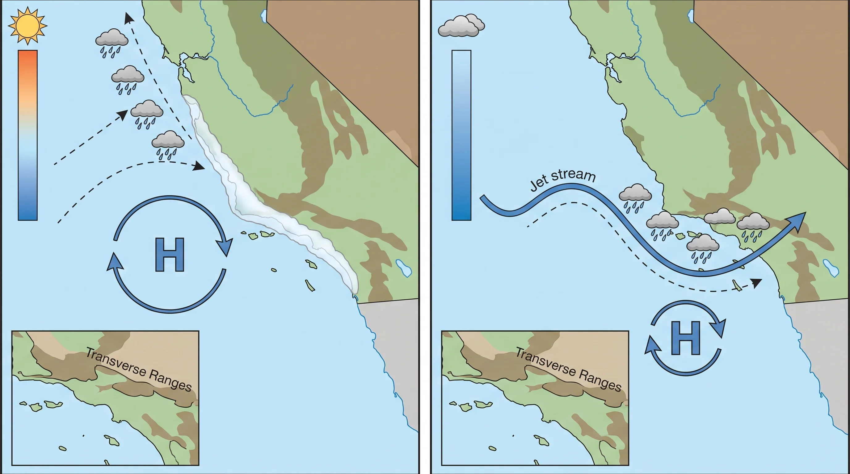
Los Angeles summers are dry because a large, semi-permanent zone of high pressure over the eastern Pacific Ocean, often called the North Pacific High or the eastern Pacific subtropical high, strengthens and shifts northward each summer, parking itself off the California coast. Sinking air inside that high pressure system suppresses cloud formation and pushes the Pacific storm track far to the north, well into Canada and the Gulf of Alaska, which keeps the fronts and low-pressure systems that bring rain away from Southern California for months at a time. This is a mechanical result of atmospheric circulation, not an absence of storms passing nearby; the storms are simply diverted north of the region.

The same high pressure system is also responsible for the marine layer, the low cloud deck and fog that so often blankets the coast on summer mornings. A subsidence inversion forms as sinking air in the high pressure system caps cooler, moist air near the ocean surface, trapping it below a layer of warmer air a few thousand feet up. That inversion can produce persistent overcast skies at the coast even while inland areas bake in full sun, but it rarely produces meaningful rainfall on its own. Coastal gray and inland heat can coexist on the same July day precisely because both are downstream effects of the same high pressure system, not competing weather patterns.

An annual circulation diagram showing the subtropical high pressure system strengthening and shifting north off the California coast in summer, blocking Pacific storms, then weakening and sliding south in winter as the jet stream dips and storm systems track into Southern California
The same subtropical high that blocks summer storms and produces the coastal marine layer weakens and retreats south each winter, opening the door for the Pacific storms that supply most of Los Angeles' annual rain.

Why Does Winter Bring Most of the Rain?

Winter brings most of Los Angeles' rain because the same subtropical high that blocks summer storms weakens and retreats south each fall, allowing the polar jet stream to dip southward and steer Pacific frontal systems into Southern California. From roughly November through March, this reopened storm track can deliver atmospheric rivers, long plumes of concentrated tropical and subtropical moisture that produce the region's heaviest rain events, along with more ordinary frontal systems that bring a day or two of steady rain. The NOAA Climate Prediction Center tracks this seasonal storm track shift as part of its routine outlooks, since the position of the jet stream from one winter to the next is a major driver of how wet or dry a given rainy season turns out to be.

That year-to-year variability is a defining feature of the region's winters, not a deviation from the pattern. A single strong atmospheric river event can supply a large share of an entire season's rainfall in a matter of days, which means Los Angeles can swing between drought years and flood-prone years depending on how many storms track far enough south to reach Southern California rather than sliding into Northern California or missing the coast entirely. The NWS Los Angeles/Oxnard office and the NWS San Diego office issue the local forecasts, watches, and warnings that track these systems as they approach, including flood and debris flow guidance for burn scar areas where a wet winter follows a dry, fire-prone year.

Why Do LA Microclimates Still Differ?

Los Angeles microclimates differ within the same regional Mediterranean climate because distance from the ocean, elevation, terrain orientation, and urban surfaces all modify how the underlying seasonal pattern plays out at any given spot. The coast, the basin, the inland valleys, and the mountains all share the same wet-winter, dry-summer calendar, but the amount of rain, the daily temperature swing, and the frequency of fog can differ sharply within a few miles.

Coastal areas stay cooler and more fog-prone in summer because they sit closest to the cold California Current offshore and are the first to receive the marine layer. Move inland to the basin, and that ocean moderation weakens; Downtown Los Angeles, sitting near sea level about 15 miles from the coast, runs both warmer summer afternoons and a wider gap between daily high and low temperature than beach communities see. Push farther inland or gain elevation, and the ocean's influence fades further still.

Woodland Hills, in the western San Fernando Valley, regularly posts some of the hottest summer afternoon readings in the county precisely because it sits inland of the Santa Monica Mountains, which block the onshore flow of cooler marine air. Pasadena, at the base of the San Gabriel Mountains in the San Gabriel Valley, shows a related but distinct pattern: foothill terrain there can trap and intensify afternoon heat while also generating localized downslope wind events under the right pressure setup.

Urban surfaces add one more layer on top of terrain and distance from the coast: dense pavement and buildings across the basin retain heat overnight, so built-up neighborhoods often stay several degrees warmer after dark than nearby open or vegetated land, even when both sit at similar elevation and distance from the ocean.

None of these local differences change the regional climate classification. Coastal fog, valley heat, and foothill wind are all local expressions of the same Mediterranean pattern, shaped by geography layered on top of the seasonal high-pressure cycle rather than separate climate types competing within the county.

How Does LA Compare With Other Mediterranean Regions?

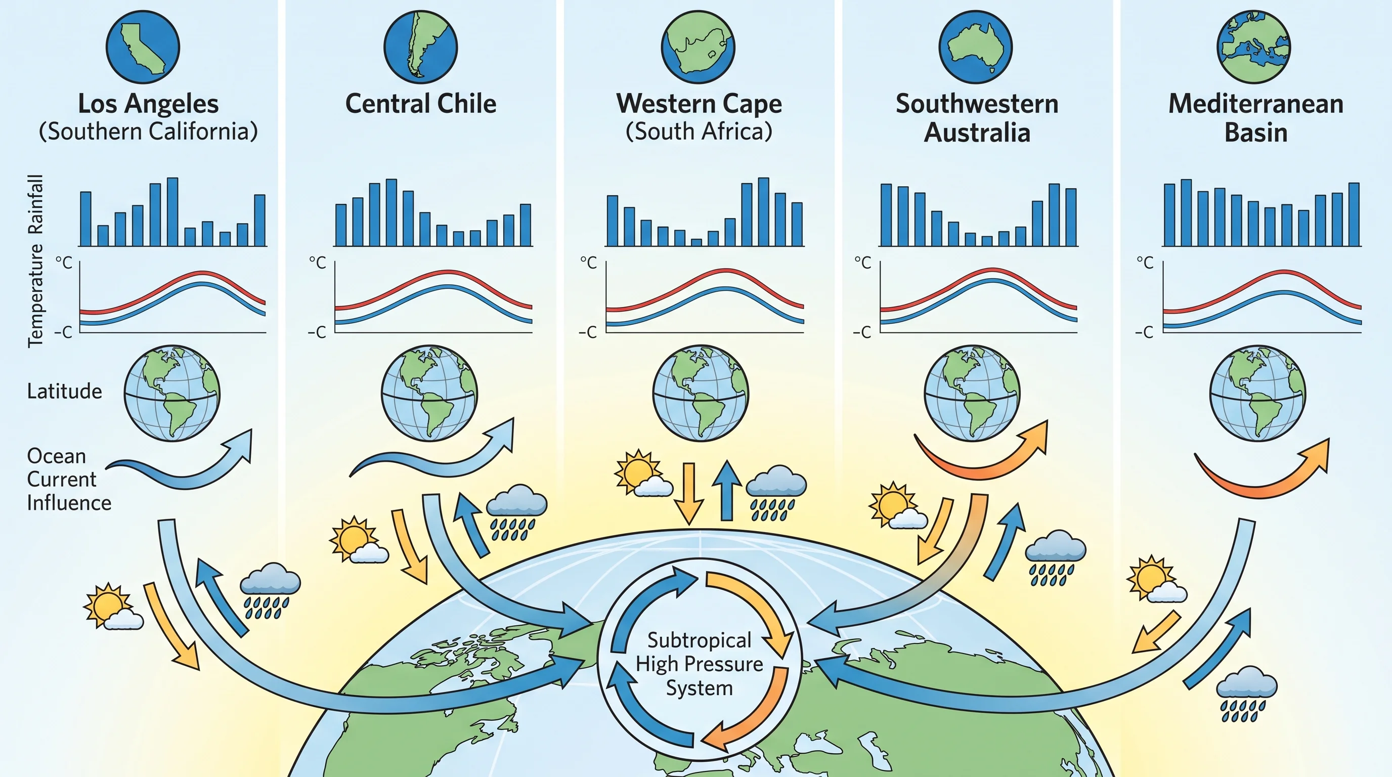
Los Angeles shares its core seasonal structure, dry summers and wet winters driven by a shifting subtropical high, with four other major regions worldwide: the Mediterranean Basin itself, central Chile, South Africa's Western Cape, and southwestern Australia around Perth. Each sits in a similar latitude band on the west side of a continent, each has a cold ocean current offshore, and each experiences the same seasonal high-pressure cycle, just shifted six months apart between the Northern and Southern Hemisphere examples.

The comparison that matters is seasonal structure, not a single annual average temperature, since headline averages can make very different climates look similar or make genuinely similar climates look different depending on which months get emphasized. Central Chile's dry season runs December through February because that is the Southern Hemisphere summer, while Los Angeles is dry in June through August. Both regions are equally "Mediterranean" in structure despite the six-month calendar offset, because both put their dry season in local summer and their wet season in local winter.

Within California itself, the northern part of the state, around San Francisco and points north, shares the same wet-winter and dry-summer calendar as Los Angeles but layers in a stronger and more persistent summer marine layer along its immediate coastline, driven by a colder adjacent stretch of the California Current and different terrain exposure.

Southern California's version of the climate also runs on the warm and dry end of the Mediterranean spectrum. Los Angeles sits closer to the desert Southwest than the wetter, cooler Mediterranean climates of Northern California or northern Europe, which is part of why the region can flip from a wet Pacific storm track in winter to genuine desert-adjacent heat and, in some years, a monsoon-driven thunderstorm pattern by late summer. That summer thunderstorm risk over the deserts east of Los Angeles, distinct from the region's normal dry-summer pattern, is covered in what is the monsoon.

A climate comparison chart for Los Angeles and other Mediterranean-climate regions, including central Chile, South Africa's Western Cape, southwestern Australia, and the Mediterranean Basin, showing monthly rainfall, temperature, latitude, and ocean current influence for each region
Los Angeles shares its dry-summer, wet-winter seasonal structure with four other Mediterranean-climate regions worldwide, each shifted by hemisphere but built from the same subtropical high pressure mechanism.

How Is the Climate Changing?

California's climate assessments show Los Angeles' Mediterranean pattern intensifying at its edges rather than disappearing: hotter extremes, more variable rainfall swinging between drought and heavy storms, and a longer fire season are all documented trends, even as the basic wet-winter, dry-summer seasonal structure itself remains intact. The NOAA Climate.gov and California's statewide climate assessment work, along with data compiled by the California Department of Water Resources, describe rising average temperatures, an increasing share of winter precipitation arriving in fewer, more intense atmospheric river events, and drought periods that stress water supply and vegetation between those wet spells.

That combination, a longer and hotter dry season plus more concentrated winter rainfall, is a major contributor to the fire weather risk Southern California now manages every fall, when dried-out vegetation from a rainless summer meets offshore Santa Ana wind events. It is worth stating plainly what these trends do not mean: Los Angeles is not scheduled to stop being a Mediterranean climate on any particular date, and no credible assessment claims the seasonal dry-summer, wet-winter pattern will vanish. What is changing is the intensity and variability layered on top of that structure, which is exactly why current conditions, current drought status, and current fire weather outlooks still need to be checked against live official sources rather than assumed from the climate type alone.

The takeaway holds up against the record: Los Angeles is dry in summer and wetter in winter because a single, well-documented mechanism, the seasonal rise and fall of the eastern Pacific subtropical high, controls the region's storm track. Coastal fog, valley heat, and foothill wind are all local variations layered on top of that same seasonal pattern, not separate climates competing across the county. Before planning a trip or a hike around the season, compare a destination's monthly temperature and rainfall normals with the current forecast on WeatherEscape's Los Angeles pages, since the Mediterranean pattern sets the general expectation but any individual week can still run wetter, drier, hotter, or cooler than the seasonal average.

The LA microclimates guide explains the local variations, while California snowpack connects the wet-season pattern to water supply.

Frequently Asked Questions

What is a Mediterranean climate?

A Mediterranean climate is a seasonal rainfall pattern, classified as Csa or Csb in the Köppen climate system, defined by dry, warm-to-hot summers and mild, wetter winters. The defining feature is timing: the warmest months of the year are also the driest, while the coolest months carry most of the annual rainfall, which is the reverse of how rainfall works across most of the world.

Why are Los Angeles summers dry?

Los Angeles summers are dry because the eastern Pacific subtropical high, a large zone of high pressure over the ocean, strengthens and shifts north each summer, parking itself off the California coast. Sinking air inside that high pressure system suppresses rain clouds and pushes the Pacific storm track north into Canada, keeping frontal systems away from Southern California for months.

Why does winter bring most of the rain?

Winter brings most of Los Angeles' rain because the subtropical high weakens and retreats south each fall, letting the jet stream dip south and steer Pacific storms and atmospheric rivers into Southern California. This reopened storm track, active roughly November through March, is highly variable year to year, so a handful of strong storms can supply a large share of an entire season's rainfall.

Why do LA microclimates still differ?

LA microclimates differ because distance from the ocean, elevation, terrain orientation, and urban surfaces all modify the same regional Mediterranean pattern at the local level. Coastal areas near the cold California Current stay cooler and foggier, inland valleys like Woodland Hills lose that ocean moderation and run hotter, and foothill towns like Pasadena add terrain-driven heat and wind on top of the shared seasonal calendar.

How does LA compare with other Mediterranean regions?

Los Angeles shares its core dry-summer, wet-winter structure with central Chile, South Africa's Western Cape, southwestern Australia, and the Mediterranean Basin, all located in a similar latitude band with a cold ocean current offshore and a seasonally shifting subtropical high. Southern Hemisphere examples are dry in December through February instead of June through August, but the underlying rule, dry in local summer and wet in local winter, is identical.

Where in the US has a Mediterranean climate?

Coastal and near-coastal California, including the Los Angeles Basin, San Diego, and the San Francisco Bay Area, is the primary US region with a Mediterranean climate. All three share the wet-winter, dry-summer calendar driven by the eastern Pacific subtropical high, though Northern California typically runs cooler and wetter than Southern California's warmer, drier version of the pattern.

Is Los Angeles a desert or a Mediterranean climate?

Los Angeles is classified as a Mediterranean climate, not a desert, because it receives enough winter rainfall to support the region's native chaparral and coastal sage scrub vegetation rather than true desert plant communities. The confusion is understandable since Southern California sits close to genuine desert climates just east of the mountains and shares some of their summer dryness and heat, but the winter rain total is the key difference.

Will climate change end LA's Mediterranean climate?

No credible assessment projects Los Angeles' Mediterranean climate structure disappearing. California climate assessments from agencies including NOAA and the California Department of Water Resources document hotter extremes, more concentrated winter rainfall arriving in fewer, larger storms, and longer fire seasons, but the basic dry-summer, wet-winter seasonal pattern itself remains intact even as its intensity and variability increase.

Related Destinations

Live Los Angeles Conditions

Compare temperature, wind, clouds, and comfort across the map.

See which microclimates are clear, cool, windy, smoky, or warming up right now.

Open the Weather Map
Destinations☀️Smog Forecast🌫️Smog Heat Map🔒Privacy Policy📄Terms of Service