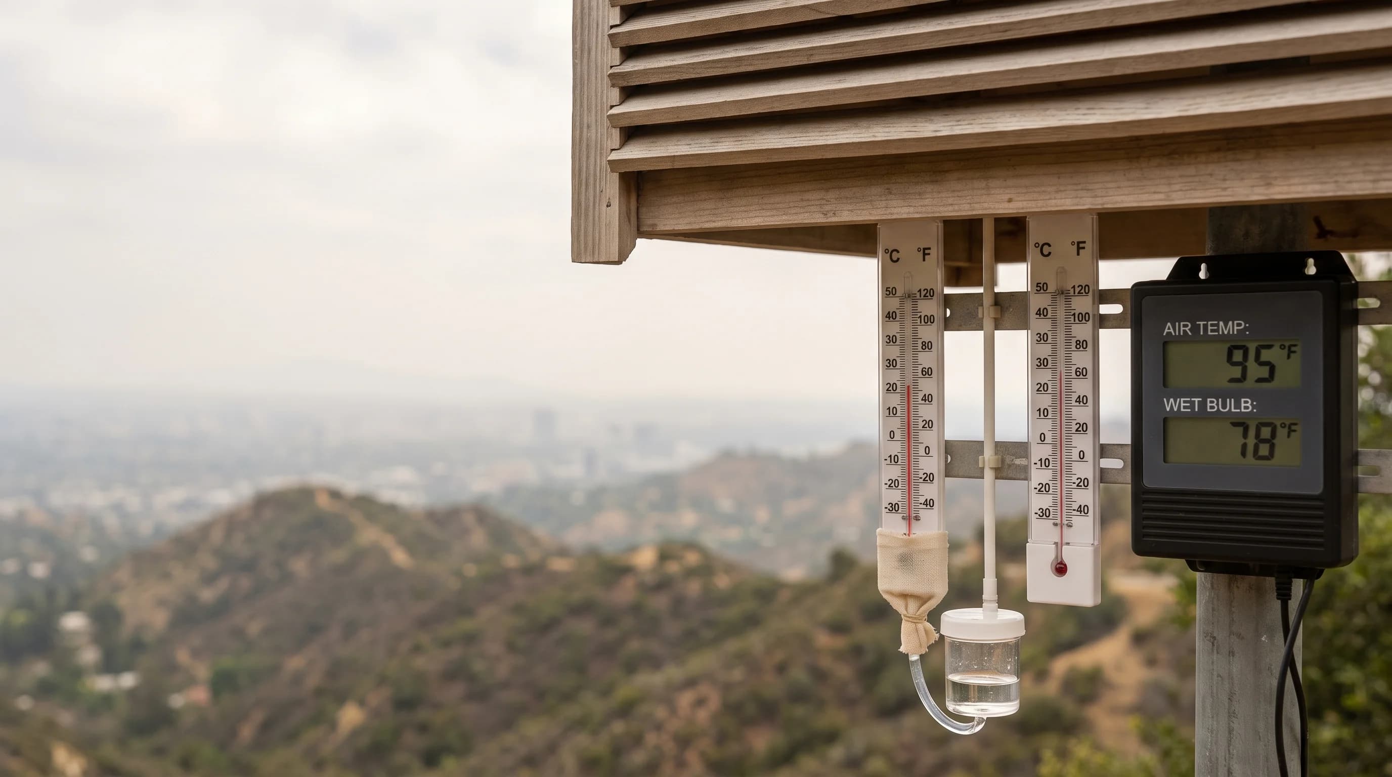
Wet-bulb temperature is the lowest temperature air can reach through evaporation alone, and it measures real heat stress far better than an ordinary thermometer. Wet-bulb temperature is always at or below the air temperature. The closer the two numbers are, the less cooling evaporation, including your sweat, can still provide. On a humid Southern California afternoon, that gap can shrink enough to matter even when the thermometer does not look alarming.
What Is Wet-Bulb Temperature?
Wet-bulb temperature is measured with a thermometer whose bulb is wrapped in a wet wick and exposed to moving air. Water evaporating from the wick pulls heat from the bulb, and the reading settles at the lowest temperature evaporation can reach in that air. Your body cools the same way: sweat absorbs heat as it evaporates from your skin.
An ordinary air temperature reading, also called dry-bulb temperature, measures how hot the air is. Wet-bulb temperature measures how much more heat the air can absorb through evaporation.
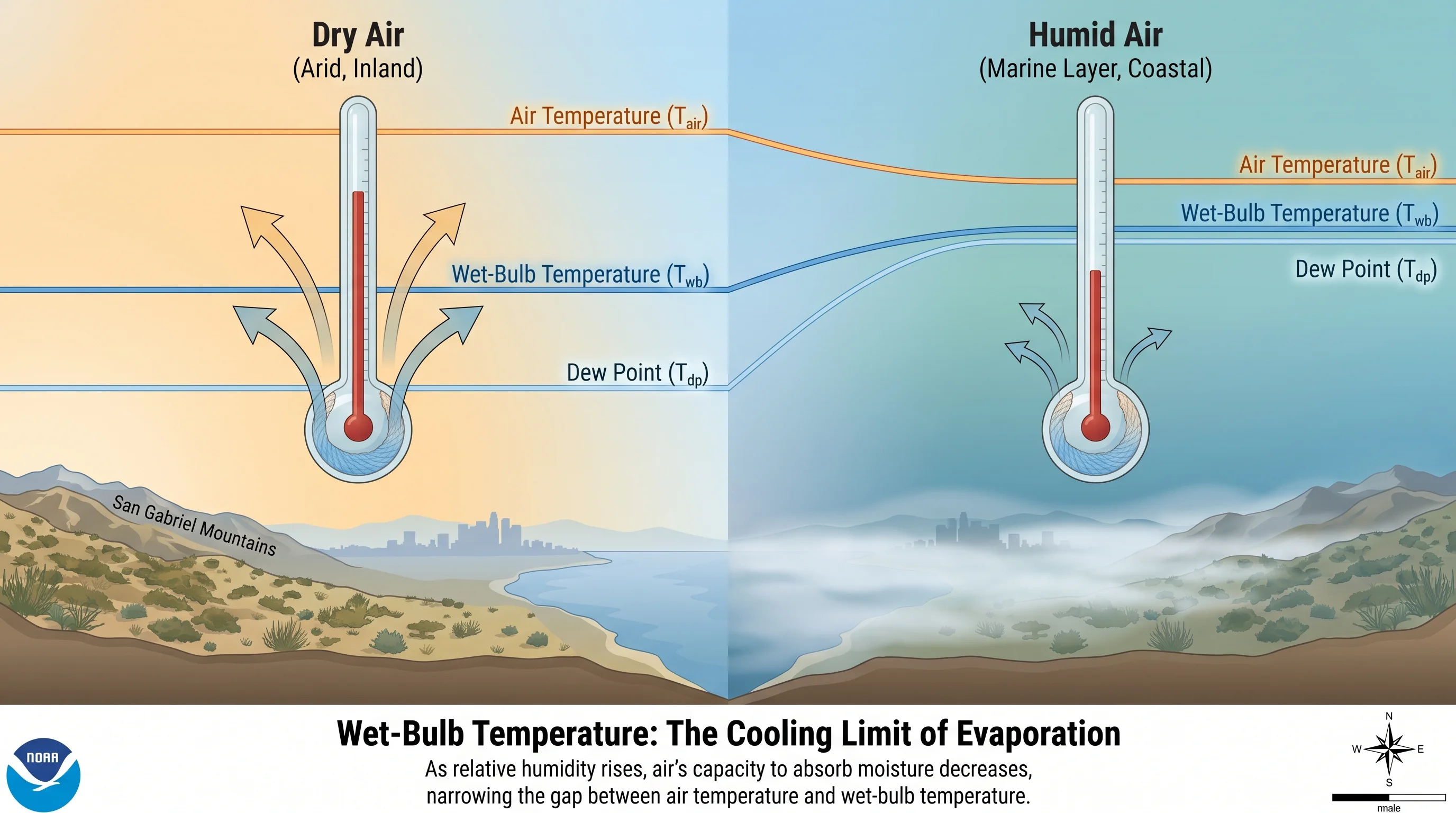
In very dry air, plenty of evaporation can still happen, so the wet-bulb reading sits well below the air temperature. In saturated air, evaporation has almost nowhere to go, so the wet-bulb reading rises to meet the air temperature. When the two are close, sweat stops cooling you well, which is why meteorologists and physiologists track wet-bulb temperature in extreme heat.
| Metric | What it measures | Inputs used | Best use |
|---|---|---|---|
| Dry-bulb (air) temperature | Actual temperature of the air itself | A standard shaded thermometer | The everyday forecast high or current reading |
| Wet-bulb temperature | Cooling limit of evaporation alone | Air temperature, humidity, and airflow over a wetted sensor | Judging how much cooling headroom sweat still has |
| Dew point | Temperature at which air becomes saturated with moisture | Air temperature and moisture content | A quick, familiar gauge of how muggy the air feels |
| Heat index | How hot humid air feels to the body, in shade | Air temperature and relative humidity, fixed shade and light-wind assumptions | General public heat-feel guidance |
| Wet Bulb Globe Temperature (WBGT) | Full outdoor heat load, including direct sun | Wet-bulb temperature, sun exposure, and actual wind speed | Setting outdoor work, sports, and military activity limits |
For the National Weather Service's feels-like number built from temperature and humidity, see what is the heat index and why LA heat feels worse than the number.
How Do Heat and Humidity Determine Wet-Bulb Temperature?
Heat and humidity determine wet-bulb temperature together: wet-bulb rises with air temperature, and humidity sets how close it gets to the air temperature. Dry air can take in much more moisture before saturating, so water evaporates fast and pulls the wet-bulb reading well below the air temperature. Humid air already holds a lot of moisture, so evaporation slows and the wet-bulb reading creeps up toward the air temperature.
Airflow matters too, though less than humidity. Moving air keeps replacing the thin, saturated layer at the surface of a wet wick or a sweaty forehead, which keeps evaporation going. Still air lets that layer build up and stall, which is part of why a breezy afternoon feels more bearable than a calm one at the same temperature and humidity. Wet-bulb temperature measured without real wind speed is therefore an incomplete picture of conditions outdoors, as explained below.
A dry 100°F day in Woodland Hills or elsewhere in the San Fernando Valley leaves plenty of room for sweat to evaporate, so its wet-bulb temperature sits well below the air temperature. A humid 85°F afternoon on the coast, where onshore air is loaded with Pacific moisture, can have a wet-bulb reading much closer to 85°F. Sweat then has far less cooling power, despite the milder thermometer reading. That is why a hot, dry inland day can be easier on the body than a cooler, muggy coastal one.
The Pacific Ocean off Southern California drives the marine layer, the shallow, cool, moist air that often covers the coast, as the NOAA Ocean Service explains. The marine layer makes coastal humidity, and coastal wet-bulb temperature, behave very differently from the drier air a few miles inland, even when both report the same air temperature.
When Can Southern California Wet-Bulb Readings Become Concerning?
Southern California wet-bulb readings become concerning mainly during humid coastal heat waves and late-summer monsoon surges, not on the hottest dry inland days. The marine layer that keeps Santa Monica and Malibu mild can, during a humid onshore push, carry enough moisture that a modest temperature produces a surprisingly high wet-bulb reading. Late-summer and early-fall monsoon moisture from the desert Southwest can raise humidity across the inland valleys and basin while temperatures are already high. That pushes wet-bulb readings up in places that are normally dry enough to handle heat.
Deep desert areas near Palm Springs, which average about 115 days a year at 100°F (see Palm Springs weather by month), show the opposite pattern. Their temperatures are the region's highest, but low desert humidity keeps wet-bulb readings fairly modest, because evaporation still works. Extreme dry heat versus milder humid heat is why a thermometer reading alone does not show heat stress. It is also why the National Weather Service Los Angeles/Oxnard office and the National Weather Service San Diego office weigh humidity as well as temperature when judging heat risk.
Timing matters as much as place. On dry inland days, wet-bulb readings in the Los Angeles Basin usually peak in mid-to-late afternoon with the air temperature. During a humid onshore event, coastal wet-bulb readings can stay high overnight, because marine air does not dry out the way it does in a Santa Ana pattern. A multi-day heat wave with humid, slow-cooling nights is harder on the body than one hot afternoon, because the body gets less relief overnight.
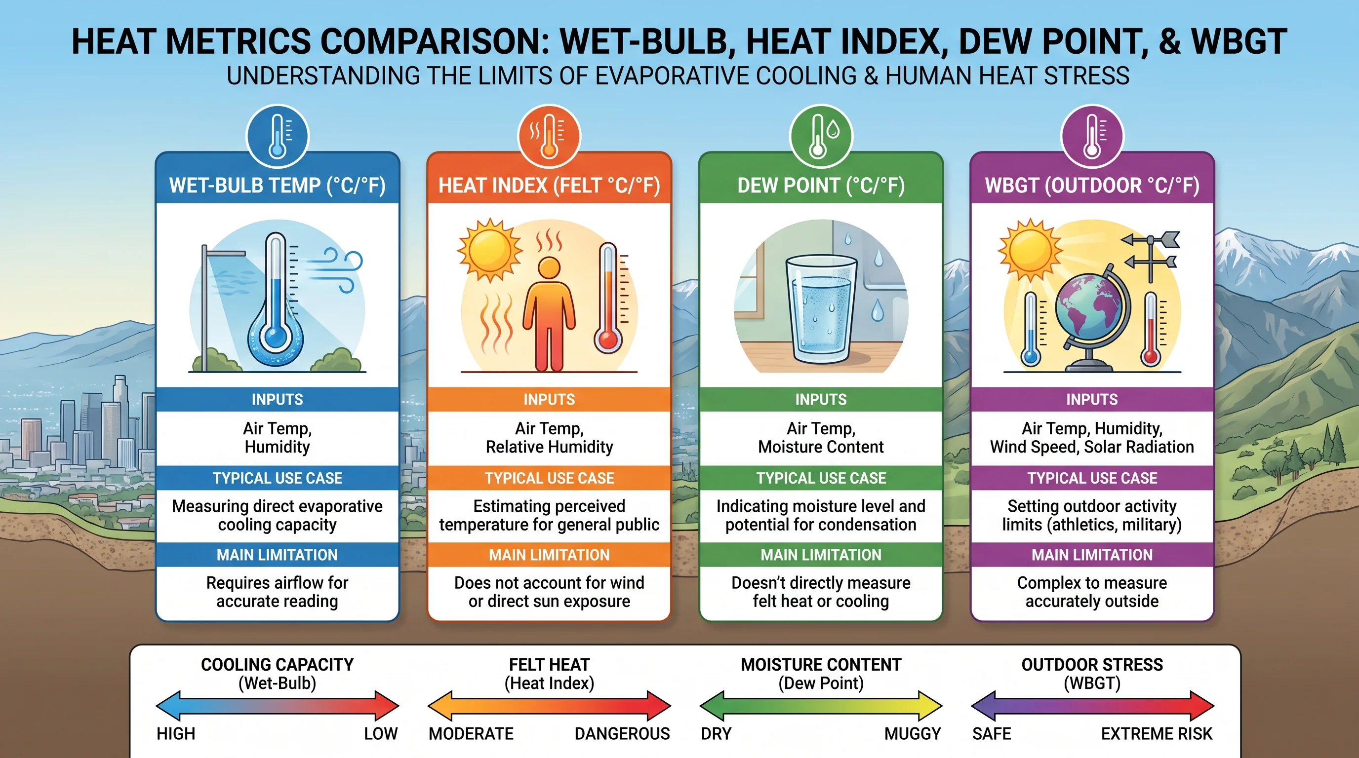
How Does Wet-Bulb Temperature Differ From Heat Index, Dew Point, and WBGT?
Wet-bulb temperature, heat index, dew point and WBGT each answer a different question. Dew point is the temperature at which the air would become saturated, and it is the quickest way to judge mugginess; a dew point in the upper 60s or higher feels sticky almost anywhere. Heat index combines air temperature and relative humidity to estimate how hot it feels in shade with a light breeze, which is why it appears with daily forecasts.
Wet-bulb temperature is a more direct physical measurement. It measures the cooling limit evaporation can reach at the current temperature and humidity. Wet Bulb Globe Temperature (WBGT) adds direct sun, measured with a black globe thermometer, and actual wind speed. Because WBGT captures the full outdoor heat load, it sets activity limits for military training, competitive sports and outdoor work safety, not plain wet-bulb temperature or heat index.
Is One Wet-Bulb Number a Universal Survival Limit?
No single wet-bulb number is a universal survival limit; treating 35°C as one is the most common misunderstanding about the metric. Physiology research often cites a sustained wet-bulb temperature of 35°C (95°F) as a theoretical ceiling.
Above it, even a healthy, resting, well-hydrated adult in shade cannot shed body heat fast enough to keep core temperature stable. The figure comes from lab and modeling studies of heat exchange between skin and air. It describes a physical ceiling, not the point where danger begins.
Danger begins at far lower wet-bulb readings once real-world factors return. Direct sun, exertion, limited shade or water, health conditions, some medications and lack of acclimatization all lower the threshold for a given person. A wet-bulb reading well below 35°C can still endanger someone working outdoors at midday, an older adult without air conditioning or a child left in a parked car.
Southern California has never recorded wet-bulb temperatures close to 35°C; the marine layer and generally moderate humidity, even during monsoon surges, keep local readings far below the world's most extreme humid heat events. Yet ordinary Southern California heat waves still send people to emergency rooms every year. Real danger depends on duration, sun, exertion and health, not on crossing one number.
The 35°C figure does not mean everyone collapses when conditions cross it, and it has not been observed at a populated Southern California weather station. It comes from modeling the point at which core body temperature would keep rising even in shade with unlimited water, because the air is too hot and humid to accept more heat.
Newer research suggests the practical limit for healthy young adults under sustained exertion may be closer to 30°C to 31°C wet-bulb. The question is still being studied, which is why local heat guidance uses broader risk indicators instead of one wet-bulb cutoff.
For how pressure systems drive Southern California heat waves, see what causes a heat wave and the heat domes behind LA's hottest days. It explains why some heat waves build over days while others spike and break quickly, which affects how long wet-bulb readings stay high.
Which Heat Guidance Should You Actually Use?
For everyday decisions, use the National Weather Service HeatRisk forecast and official heat safety guidance instead of estimating wet-bulb temperature yourself. HeatRisk already accounts for how unusual the heat is for the season, how long it will last and how warm nights stay, which matter more to health than one wet-bulb reading. During a heat event, the NWS Los Angeles/Oxnard office and the NWS San Diego office issue Heat Advisories and Extreme Heat Warnings, formerly Excessive Heat Warnings, with specific thresholds and timing for their areas.
For hard outdoor work or organized sports, look for a posted WBGT reading or activity schedule from the organization running the activity, since WBGT is the standard for those rules. For everyone else, from a family in Pasadena planning an afternoon outside to a jogger in Downtown Los Angeles, check the current temperature, humidity and any heat alert on WeatherLA's Los Angeles forecast pages before heading out. Wet-bulb temperature explains why some hot days are more dangerous; HeatRisk and official alerts tell you what to do.