summerclimate sciencesafetyphenomena

How High Pressure Traps LA Under a Heat Dome

By WeatherLA|Published |Last updated |11 min read
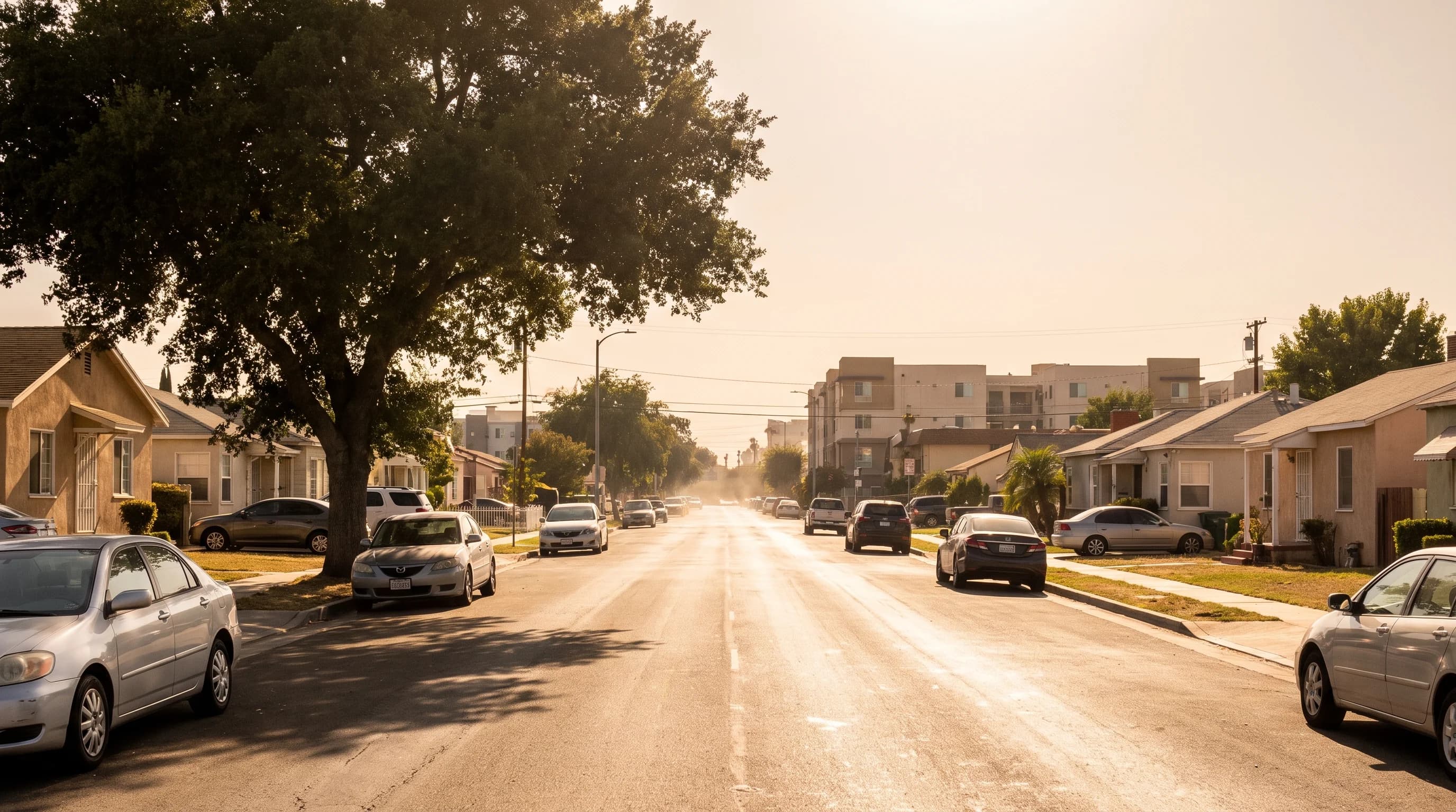
A hot Los Angeles afternoon shown across the coastline, a dense basin neighborhood, and an inland valley, with visible heat haze and no marine layer cloud at the coast

Key Takeaways

  • A Los Angeles heat wave forms when a persistent upper-level high-pressure ridge parks over the region, sinking air that warms and dries as it descends and blocks the normal marine cooling cycle.
  • The National Weather Service defines a heat wave locally, weighing how a stretch of days compares to that specific location's own climatology rather than one fixed statewide temperature threshold.
  • Offshore flow, wind blowing from the desert toward the ocean, can push the marine layer out to sea and send even beach towns like Santa Monica into unusually hot afternoons.
  • Warm nighttime lows, not just the daytime peak, are what push a heat wave into dangerous territory, since the body and buildings both need cooler air overnight to recover.
  • NWS HeatRisk is a location-specific, day-by-day tool and is a more useful planning reference than a single county-wide temperature number.
  • Inland communities without reliable air conditioning or tree canopy carry more heat risk than the daytime high alone would suggest, especially across consecutive hot days.

A Los Angeles heat wave builds when a large, slow-moving ridge of high pressure parks over Southern California, sinking air that compresses and warms as it drops. That sinking air clears the skies, shuts down the marine layer that normally cools the coast, and lets heat accumulate for days instead of breaking overnight. The result is not one hot afternoon but a stacked pattern: hotter days, warmer nights, and a coastline that loses its usual protection right along with the inland valleys.

What Counts as a Heat Wave in Los Angeles?

The National Weather Service does not use one fixed statewide temperature to define a heat wave. Instead, the NWS Los Angeles/Oxnard office and the NWS San Diego office evaluate how a stretch of days compares against a specific location's own climatology: how unusual the daytime highs are for that place and time of year, how many consecutive days the pattern lasts, and critically, how much the overnight low actually drops. A run of 85-degree afternoons is unremarkable in July in the San Fernando Valley but can qualify as a genuine heat event along the coast, where the ocean normally keeps summer highs in the 70s.

That local framing matters because Los Angeles is not one climate. A single heat dome event can leave Santa Monica only modestly warm while Pasadena and the inland valleys climb well past 100°F on the same afternoon. Understanding what drives that split starts with the mechanism itself, the upper-level ridge that forecasters call a heat dome.

How a Heat Dome Reaches Different Los Angeles Zones
ZoneMarine layer protectionTypical heat dome response
Santa Monica / Malibu (coast)Strong on an ordinary dayUsually the last area to heat up; can spike suddenly if offshore flow pushes the marine layer out to sea
Downtown Los Angeles (basin)Partial, weakens with distance from the coastWarms notably above its own normal within a day or two
Pasadena (foothill basin)Limited, sits against the San Gabriel frontAmong the first areas to run well above 100°F under a strong ridge
San Fernando and San Gabriel Valleys (inland)Minimal to noneHighest sustained daytime highs and among the warmest overnight lows in the region

How Does a Heat Dome Build Over Southern California?

A heat dome starts hundreds or thousands of feet above the ground, with a broad ridge of high pressure in the upper atmosphere. Air beneath that ridge is forced to sink, and sinking air compresses as atmospheric pressure increases closer to the surface. That compression warms the air, often by several degrees for every thousand feet it descends. High pressure also suppresses cloud formation, so the sinking, warming air arrives under largely clear skies, which lets more direct solar energy reach the ground on top of the warming the air mass already carries.

The defining feature of a heat dome is not a single hot day but persistence. Because the ridge is a large, slow-moving feature, it can stay anchored over the same stretch of the West Coast for several days to more than a week before a trough or a shift in the jet stream finally displaces it. Every additional day under the ridge compounds the last: dry ground from the previous afternoon heats faster the next day, and the atmosphere itself retains more accumulated warmth, according to research summarized by NOAA Climate.gov.

This is distinct from a single afternoon of heat driven by strong sun angle alone; a heat dome is a multi-day pattern with its own atmospheric signature that forecasters can track and anticipate days in advance using upper-air models from the NOAA Climate Prediction Center.

Southern California's ridges usually form as an extension or a northward bulge of the semi-permanent subtropical high pressure system that normally sits out over the eastern Pacific each summer. When that ridge amplifies and shifts east over the Southwest instead of staying offshore, it places Los Angeles directly under the sinking-air side of the pattern rather than under the onshore flow the ridge produces when it sits farther out to sea. The same feature that keeps a typical Southern California summer dry and sunny can, when it strengthens and drifts inland, become the engine of a heat wave.

Forecasters at the NOAA Climate Prediction Center watch the position and strength of this ridge days in advance, which is why Southern California heat waves are rarely a surprise to meteorologists even when they catch residents off guard.

A heat dome ends the same way it starts: through a change in the upper-level pattern rather than through any local process. A trough approaching from the north or west, a shift in the jet stream, or the ridge simply weakening and retreating back offshore all restore the normal cycle of onshore flow and marine cooling. Because that shift is governed by large-scale atmospheric movement, the exact day a heat wave breaks is typically forecastable 24 to 72 hours ahead, even when the ridge's peak strength and duration were harder to pin down when the event began.

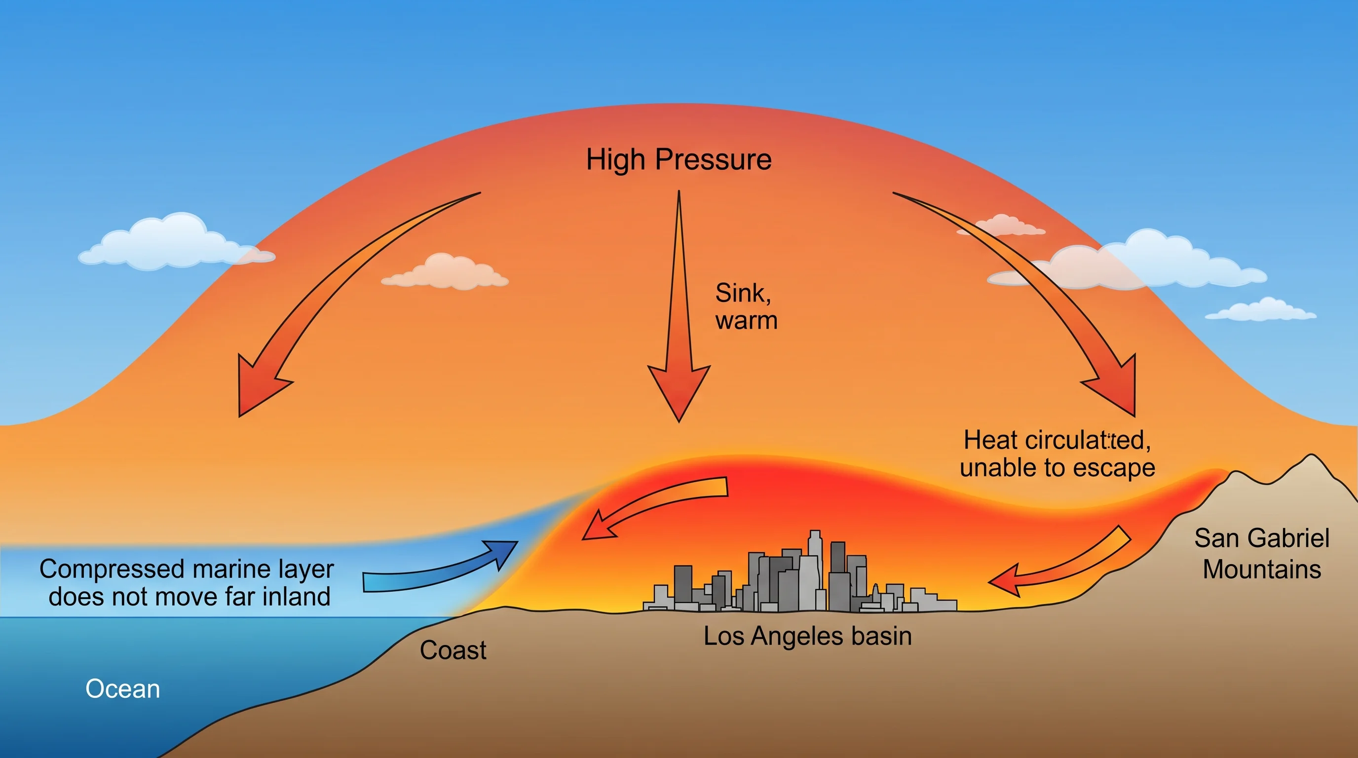
An atmospheric cross-section diagram showing an upper-level high-pressure ridge over Southern California, arrows indicating sinking and warming air, clear skies, a suppressed and thinned marine layer along the coast, and retained heat near the ground overnight
A heat dome is built from the top down: an upper-level ridge forces air to sink and warm, clears the sky, and cuts off the marine layer's usual cooling before the heat ever reaches the surface.

Why Can the Los Angeles Coast Suddenly Turn Hot?

On an ordinary summer day, the Los Angeles coast stays mild because of a daily cycle: the land heats faster than the ocean, that temperature difference pulls in a cooling sea breeze, and a marine layer of cool, moist air often blankets the shoreline overnight and into the morning. A heat dome can interrupt that entire cycle through offshore flow, wind that reverses direction and blows from the interior desert out toward the ocean instead of the other way around.

Offshore flow pushes the marine layer and the sea breeze that would normally develop out over open water, and it replaces both with dry, warming air moving downslope from the interior. Because that shift can happen within a single day, coastal spots like Santa Monica and Malibu can go from a typical marine-layer-cooled afternoon in the 70s to well above 90°F with comparatively little advance warning to residents who are used to the coast being the reliable escape from inland heat. The NOAA Ocean Service and NOAA Tides and Currents both track the sea surface and coastal atmospheric conditions that make this daily cooling cycle possible in the first place, and both show how thin the coast's thermal buffer really is once offshore flow removes it.

Inland valleys never had that buffer to lose. Because the San Fernando and San Gabriel Valleys sit beyond the reach of the daily sea breeze even on a normal day, a heat dome does not need to defeat any local cooling mechanism there. It simply adds its own compounding warmth on top of an already hotter baseline, which is why inland highs during a heat wave routinely run 15 to 25 degrees above what the coast experiences on the same afternoon.

Which Los Angeles Communities Face the Most Heat Exposure?

Exposure during a heat dome is shaped by both regional climate and local urban form, and the two layer on top of each other rather than substituting for one another. Regionally, inland basin and valley communities lose the marine layer's cooling influence entirely, which puts them at a structural disadvantage before any other factor is considered. Within those inland areas, exposure climbs further in neighborhoods with less tree canopy, more paved and built surface area, older housing stock without central air conditioning, and lower household access to reliable cooling, a pattern documented in urban heat island research and covered in depth in how the urban heat island effect works in Los Angeles.

This is a combination of factors rather than a fixed ranking of neighborhoods, and it means the same forecast high can carry meaningfully different real-world risk from one block to the next. A 100°F forecast in a shaded, well-cooled area is a different practical situation than the same number in a dense, pavement-heavy neighborhood with limited access to air conditioning, even though both would show identically on a regional weather map.

A common misconception is that a heat dome is simply a hot day that arrives without warning, similar to any other warm afternoon. In practice, a heat dome is a distinct, forecastable atmospheric pattern with a beginning, a multi-day duration, and a predictable end, not a random spike. Another frequent mix-up is treating the heat dome itself and the urban heat island as the same phenomenon: the heat dome is the regional atmospheric cause raising the baseline temperature everywhere, while the heat island is a separate, local effect layered on top of it in built-up neighborhoods. Confusing the two can lead to the mistaken belief that redesigning one neighborhood would prevent a region-wide heat wave, when the ridge itself is a synoptic-scale feature that no local intervention can alter.

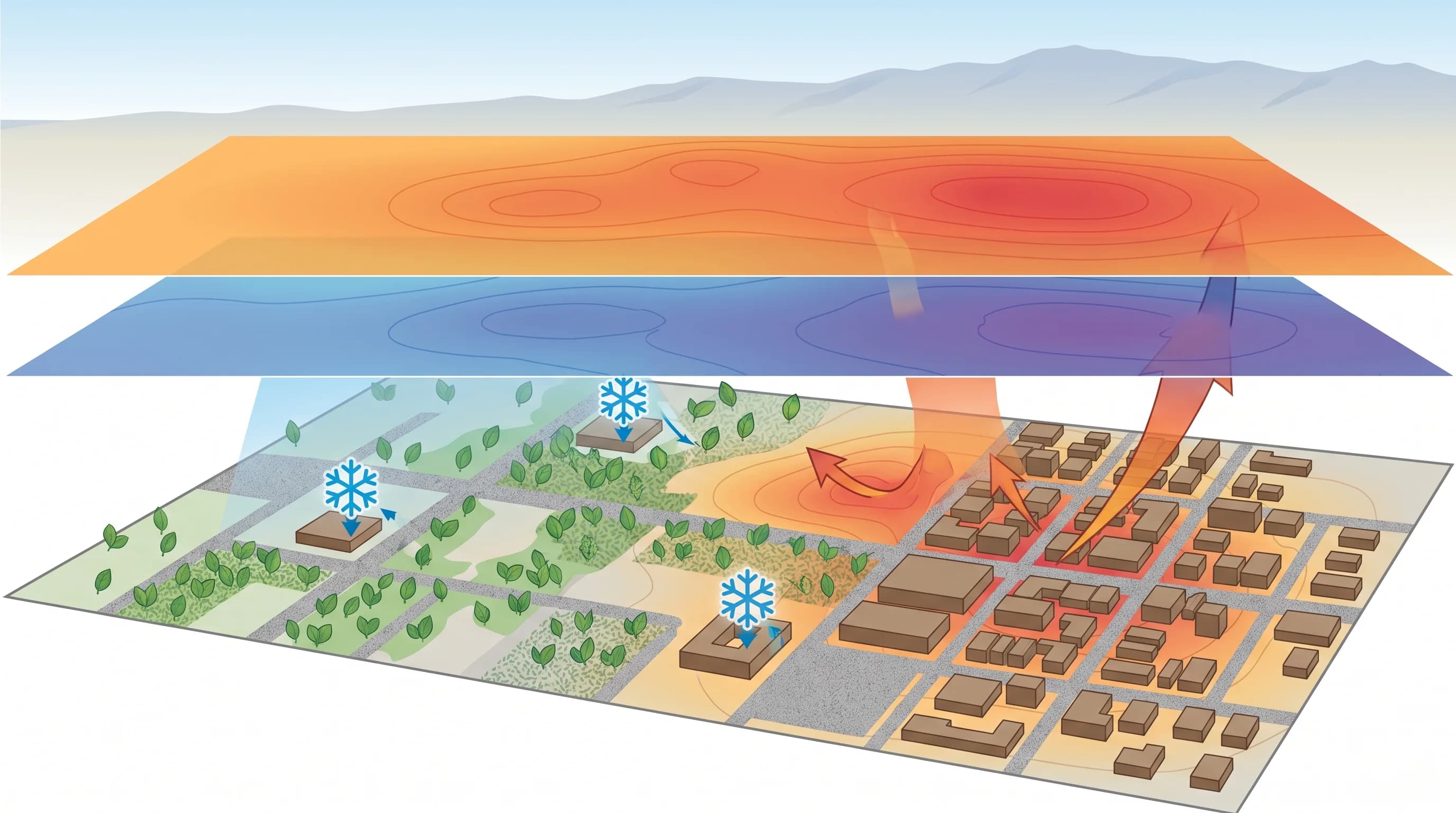
A neighborhood heat-risk graphic combining daytime high temperature, overnight low temperature, tree canopy coverage, pavement density, building density, and cooling-center locations across a Los Angeles inland neighborhood
Heat exposure during a heat dome depends on more than the forecast high: tree canopy, pavement, building density, and access to cooling all shift how dangerous the same temperature actually is.

Why Do Warm Nights Make a Heat Wave More Dangerous?

The human body needs a period of cooler air to recover from a hot day, and so do buildings without air conditioning. Under a heat dome, overnight lows often stay unusually high because the same clear skies and sinking air that produce the daytime heat also limit the radiational cooling that normally happens after sunset. When a home never drops below the mid-70s or 80s overnight, occupants get little physiological relief before the next day's heat begins building again.

Public health researchers treat a run of warm nights, not just hot afternoons, as one of the strongest predictors of heat-related illness during an extended event. The danger is cumulative: a single hot day with a cool night afterward is far less risky than several consecutive days and nights that never let the body or the building fully reset. This cumulative-stress pattern is also why the same peak daytime temperature can be far more dangerous on day four of a heat wave than it was on day one.

How Should You Use Heat Alerts and HeatRisk During a Los Angeles Heat Wave?

The most useful planning tool is NWS HeatRisk, a location-specific, day-by-day index that accounts for how unusual the heat is for a given place and time of year, how long it lasts, and whether nighttime relief is expected. Because HeatRisk is built location by location rather than as a single countywide figure, it is a better guide for a specific trip or outdoor plan than a general regional forecast headline. Pair it with any active heat product issued by NWS Los Angeles/Oxnard or NWS San Diego for your area, and check the exact forecast for your actual destination rather than assuming one number applies citywide.

HeatRisk is designed to be actionable rather than purely descriptive. Its levels move from minor, where heat is unlikely to affect most people, up through major and extreme, where the combination of daytime heat and limited overnight relief poses a risk even to healthy adults who are active outdoors. Because the index already weighs how unusual the heat is for a specific place and season, a HeatRisk level of major in coastal Malibu, where such heat is rare, reflects a genuinely different risk profile than the same level inland, even if the raw temperature forecast looks similar. Checking HeatRisk alongside a destination-specific forecast, rather than either one alone, gives the fuller picture before committing to a hike, an outdoor event, or a day at the beach during a heat dome.

Timing also matters for planning. Because the exact months and week-to-week likelihood of a heat dome shift through the summer and into early fall, it helps to know which stretch of the calendar carries the highest baseline risk before you plan travel or outdoor work; the hottest months in Los Angeles breaks down how that timing differs between the coast, basin, and inland valleys. And because the same air temperature can feel very different depending on humidity, it is worth checking why LA heat feels worse than the number on the thermometer and, for the most extreme combined heat-and-humidity events, what wet-bulb temperature means during a Southern California heat wave.

The mechanism behind a Los Angeles heat wave is straightforward once you see it laid out: a ridge builds, air sinks and warms, the marine layer loses its grip on the coast, and heat accumulates day over day until the pattern finally breaks. What that mechanism means for you depends entirely on where you are standing when it happens, from a suddenly hot afternoon in Malibu to a sweltering week in Pasadena. Before you head outdoors, exercise, or travel during a heat dome, check your destination's current high, overnight low, HeatRisk level, and any active heat alert on WeatherEscape rather than relying on a single regional number.

Frequently Asked Questions

What counts as a heat wave in Los Angeles?

There is no single statewide degree threshold. The National Weather Service defines a heat wave relative to a location's own climate normals, factoring in how many consecutive days temperatures run well above what is typical for that specific place and time of year, plus how little overnight cooling occurs. A stretch that qualifies as a heat wave in coastal Santa Monica, where 80 degrees is unusual, can be an ordinary July week in the inland San Fernando Valley.

How does a heat dome build over Southern California?

A heat dome starts with a large, slow-moving ridge of high pressure in the upper atmosphere. Air beneath that ridge sinks, and sinking air compresses and warms as it descends, while high pressure also keeps skies clear so more solar energy reaches the ground each day. The ridge can stay parked over the same region for several days to more than a week, and each additional day adds more accumulated heat before the pattern finally breaks down.

Why can the Los Angeles coast suddenly turn hot?

The coast depends on the daily sea breeze and marine layer to stay mild, and a heat dome can shut both down through offshore flow, wind reversing to blow from the interior desert out toward the ocean. Offshore flow pushes the marine layer and its cooling onshore breeze out over the water, so beach communities that normally sit in the 70s can spike well above 90 once that protective flow disappears, sometimes with almost no warning the day before.

Which Los Angeles communities face the most heat exposure?

Inland valley and basin neighborhoods generally see higher heat exposure than coastal areas because they lose the marine layer's cooling influence entirely, and within those inland areas, exposure rises further in places with less tree canopy, more pavement, older housing stock, and lower rates of air conditioning access. This is a combination of regional climate and local urban form rather than any single ranked list, and it means the same forecast high can carry very different real-world risk from one neighborhood to the next.

Why do warm nights make a heat wave more dangerous?

The human body and buildings both rely on overnight cooling to recover from a hot day. When nighttime lows stay unusually high, a common feature of multi-day heat domes, indoor spaces without air conditioning never fully cool down, and the body gets less relief before the next day's heat begins. Public health researchers treat a string of warm nights as one of the strongest predictors of heat-related illness during an extended heat wave.

How should you use heat alerts and HeatRisk during a Los Angeles heat wave?

Check the NWS HeatRisk tool and any active heat product for your specific area rather than relying on a single county-wide number, since HeatRisk is built location by location and day by day. Pair that with an exact forecast for the destination you care about, since a heat dome's effects on a Malibu beach and a Pasadena inland neighborhood on the same afternoon can differ by 20 degrees or more.

Is a heat dome the same thing as climate change?

No. A heat dome is a specific, short-lived atmospheric pattern, an upper-level ridge that traps and intensifies heat for days at a time, while climate change is a long-term shift in average conditions over decades. Research from NOAA's Climate Prediction Center and Climate.gov indicates a warming climate is making the underlying conditions for heat waves more frequent and intense, but any single heat dome event is a weather pattern, not a direct measurement of climate change itself.

Does a heat dome affect the whole Los Angeles region equally?

No, and that unevenness is one of the defining features of a Southern California heat wave. The same ridge of high pressure can leave the coast only mildly warm if the marine layer holds on, push inland valleys into the triple digits, and produce dramatically different overnight lows across basin, valley, and coastal neighborhoods, which is why checking a destination-specific forecast matters more during a heat wave than during ordinary weather.

Related Destinations

Live Los Angeles Conditions

Compare temperature, wind, clouds, and comfort across the map.

See which microclimates are clear, cool, windy, smoky, or warming up right now.

Open the Weather Map
Destinations☀️Smog Forecast🌫️Smog Heat Map🔒Privacy Policy📄Terms of Service