healthsafetysummercity guideclimate science

LA UV Can Hit "Very High" Under Gray, Cool Skies

By WeatherLA|Published |Last updated |12 min read
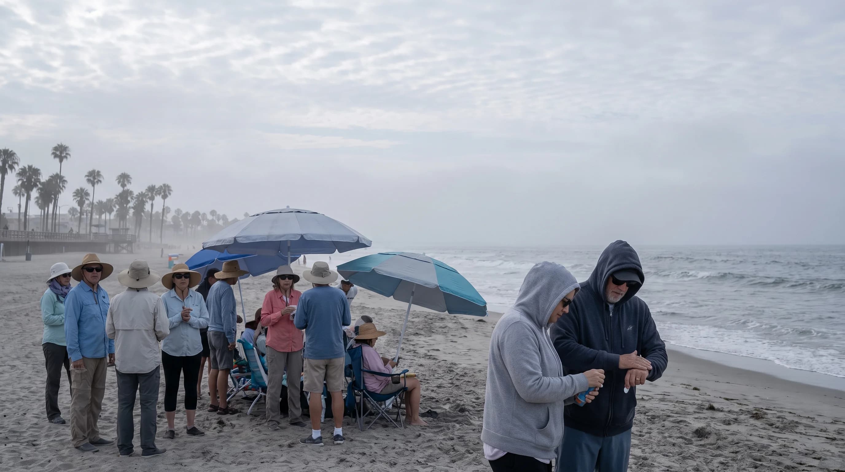
A cool Los Angeles beach under a thin marine cloud layer with beachgoers using shade, wide-brimmed hats, sunglasses, and covering clothing despite the mild-looking weather

Key Takeaways

  • The UV Index measures sunburn-producing ultraviolet radiation on an EPA 0-to-11+ scale, and it tracks sun angle, not air temperature or visible brightness.
  • A cool, hazy marine layer morning in Los Angeles can still register a High or Very High UV forecast, because thin coastal stratus blocks only a portion of ultraviolet radiation.
  • Los Angeles's roughly 34-degree-north latitude, frequent clear high-pressure skies, and elevation gain toward the foothills all push UV readings higher, independent of temperature.
  • UV exposure peaks within about two hours of solar noon, and Southern California readings generally run highest from late spring through summer and lowest in December and January.
  • Partly cloudy skies can occasionally increase UV at the surface through a cloud-edge reflection effect, so scattered clouds should never be treated as reliable sun protection.
  • The EPA ties each UV category (Low, Moderate, High, Very High, Extreme) to specific shade, clothing, sunscreen, and eye-protection guidance that residents should check by forecast, not by how the sky looks.

The UV Index is a 0-to-11+ forecast scale for sunburn-producing ultraviolet radiation, and in Los Angeles it can read High or Very High even on a cool, cloudy, or breezy day. That disconnect trips up a lot of residents and visitors: UV strength tracks the sun's angle in the sky, not the air temperature you feel on your skin. A foggy 65°F morning at Downtown Los Angeles can carry nearly as much burn risk by midday as a clear 85°F afternoon, because the marine layer that keeps the thermometer down does very little to block UV.

What does the UV Index measure?

The UV Index measures the intensity of erythemal ultraviolet radiation, the specific band of UV energy that causes sunburn and skin damage, on a scale that the EPA UV Index scale divides into five categories: Low, Moderate, High, Very High, and Extreme. It is a forecast of exposure risk, published for solar noon at a given location and date, not a measurement of visible brightness, cloud cover, or how hot the day feels. A gray, overcast sky can still sit under a High or Very High UV forecast, and a cool coastal breeze does nothing to change the number, because the index tracks ultraviolet wavelengths that pass through many of the same clouds that dim visible light only partially.

It also is not a count of how many hours of sunlight a location gets, and it is not interchangeable with heat warnings or air quality alerts. A day can register a low UV Index and still be dangerously hot, and a day can register an extreme UV Index while staying mild and comfortable. Southern California readers who want the heat side of that equation, rather than the sun-exposure side, should see what is the heat index and why LA heat feels worse than the number, which covers a related but distinct measurement.

EPA UV Index Categories and Protection Guidance
UV IndexCategoryEPA-recommended protection
0 to 2LowSunglasses on bright days; minimal risk for most skin types during typical outdoor time
3 to 5ModerateSeek shade during midday hours; wear a hat, sunglasses, and sunscreen
6 to 7HighReduce midday sun exposure; hat, sunglasses, SPF 30+ sunscreen, and protective clothing recommended
8 to 10Very HighMinimize sun exposure between roughly 10 a.m. and 4 p.m.; all protective measures strongly advised
11+ExtremeTake all precautions; unprotected skin and eyes can burn in minutes during peak hours

Why can Los Angeles UV be high?

Los Angeles sits at roughly 34 degrees north latitude, close enough to the subtropics that the sun climbs high in the sky for a large part of the year, and that sun angle, not the air temperature, is the dominant control on UV intensity. Southern California's clear, dry, high-pressure weather pattern for much of spring through fall means fewer thick clouds to attenuate ultraviolet radiation, and the region's frequent clean, haze-free air during offshore wind events lets more UV reach the ground. Elevation adds another factor: UV intensity increases with altitude because there is less atmosphere to absorb it, so a foothill city like Pasadena, sitting higher than the coastal basin, can register a modestly higher UV reading than a sea-level beach on an otherwise similar day.

Reflection matters too. Light-colored concrete, sand, and water bounce ultraviolet radiation back up at skin and eyes that are already facing the sun overhead, which is why a beach day or a walk through a bright downtown plaza can deliver more cumulative UV exposure than the index alone suggests. None of this is driven by heat. The stratospheric ozone layer, which absorbs most of the sun's most damaging shortwave UV before it reaches the surface, varies somewhat by season and latitude, but it does not track daily temperature swings, and neither does the UV Index.

A cool, breezy day with a thin, high-pressure sky over the Los Angeles Basin can still push the UV Index into the High or Very High range, which is the core reason this number surprises so many residents.

A useful way to separate these variables is to picture two very different Los Angeles days with the same UV forecast. One is a clear, warm September afternoon at 82°F with a light offshore breeze. The other is a cool, hazy June morning at 66°F with a low marine deck that burns off by midday. Both can register the same High or Very High UV reading at solar noon, because the marine layer thins as the sun climbs and does little to change the underlying sun angle or the clean air mass typical of an offshore flow pattern.

Southern California's dry season, roughly May through October, tends to compound these factors: fewer storm systems mean fewer thick cloud decks, and the same high-pressure ridge that keeps the region dry also keeps skies clear enough for UV to reach the ground largely unimpeded for weeks at a time.

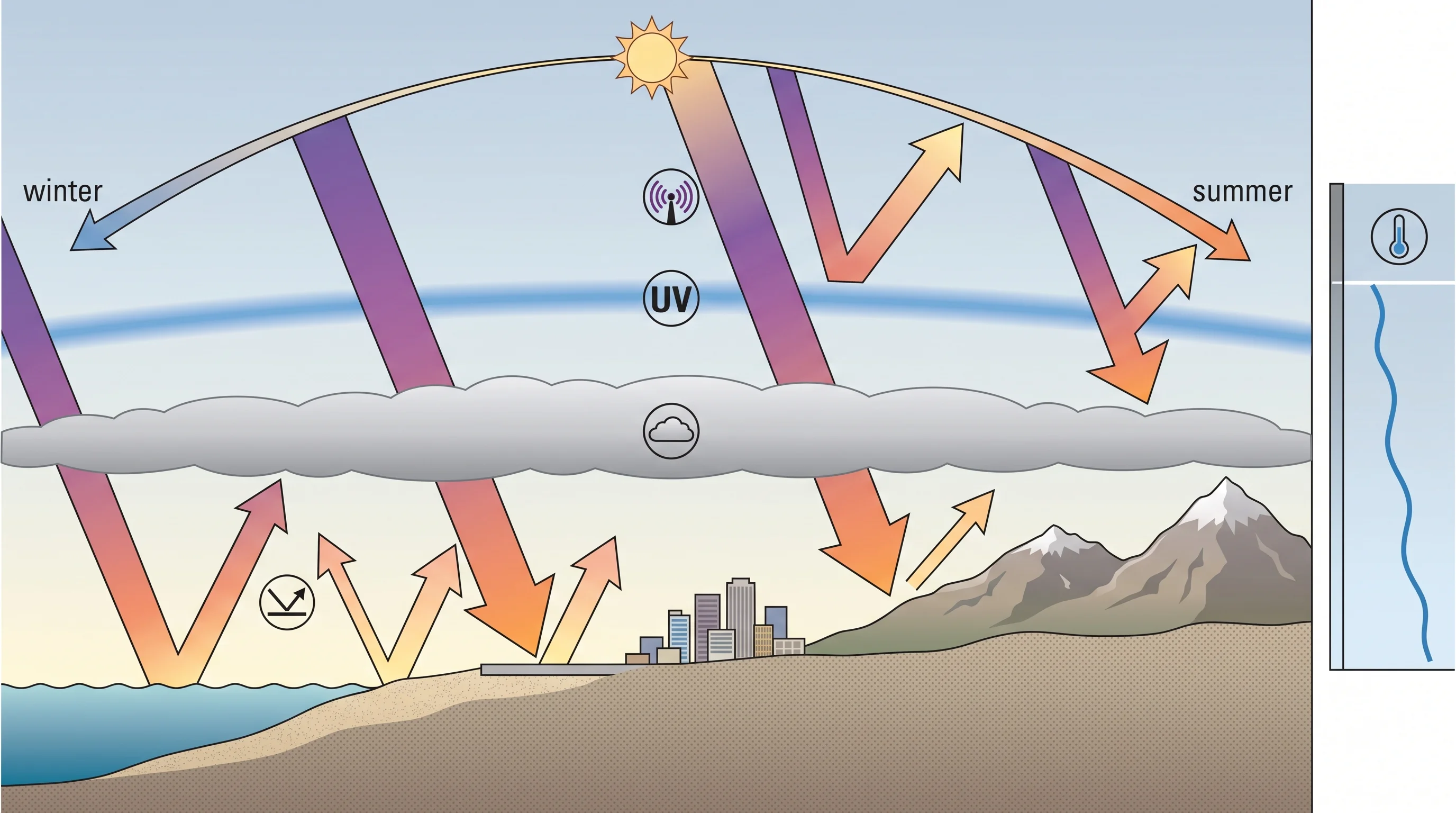
A solar-geometry diagram showing ultraviolet radiation intensity changing with season, time of day, elevation, cloud thickness, ground reflection, and stratospheric ozone, with air temperature shown as a separate, unrelated line
UV intensity is controlled by sun angle, elevation, clouds, reflection, and ozone, not by how hot or cold the air feels.

How do season and time of day change exposure?

UV exposure peaks within a couple of hours of solar noon, roughly between late morning and mid-afternoon depending on the time of year, because that is when the sun sits highest and its rays travel the shortest path through the atmosphere. Seasonally, Los Angeles UV forecasts from the National Weather Service Los Angeles/Oxnard office and the EPA typically run highest from late spring through summer, when the sun angle is steepest, and lowest in December and January, when the sun stays lower in the sky all day. Even so, a clear late-winter afternoon in the Los Angeles Basin can still reach Moderate to High on the UV Index, which is higher than many residents expect for that time of year.

The index does not translate into one fixed "safe" number of minutes outdoors, because that depends heavily on skin type, altitude, reflective surroundings, and how much protection someone is wearing. What the forecast reliably tells a reader is the relative risk for a given day and hour, useful for deciding when to schedule an outdoor activity rather than for calculating an exact burn countdown. A midday hike near Woodland Hills in July, for example, sits under a materially higher UV forecast than the same trail at 9 a.m. or 4 p.m., even though the air temperature difference across those hours might be smaller than the change in UV risk.

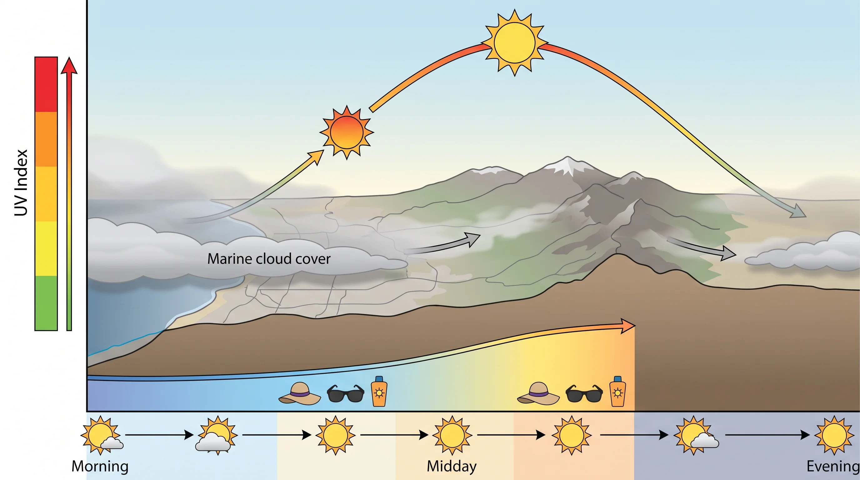
An hourly UV forecast chart for a Los Angeles summer day, matching rising and falling UV Index categories to sun angle, marine cloud cover, destination elevation, and EPA protection actions through the day
UV Index typically peaks within about two hours of solar noon and drops sharply in the early morning and late afternoon, even when the air temperature keeps climbing into the evening.

Can marine clouds or smoke block UV?

Marine clouds and haze reduce UV somewhat, but not reliably enough to skip protection, and thin or scattered clouds can occasionally enhance UV at the ground through a cloud-edge reflection effect rather than reducing it. The Southern California marine layer common at the coast in late spring and early summer is often a thin, low deck of stratus that visibly dims the sky while still letting a large share of ultraviolet radiation through, which is why a gray "May gray" or "June gloom" morning at the beach does not mean low sunburn risk.

Thick, dark overcast blocks considerably more UV than a thin marine layer, but visible dimness is not a reliable stand-in for an actual UV forecast, since two equally gray-looking mornings can carry different UV readings depending on cloud thickness and how much of the sky they cover.

The cloud-edge effect is worth understanding on its own, because it runs against intuition. When the sun is partially obscured by the ragged edge of a cloud rather than buried under solid overcast, sunlight scattering off the sides of nearby cloud towers can briefly add to direct UV at the surface rather than subtract from it. This is why some of the more surprising sunburns happen on days that look partly cloudy rather than fully clear, since a person can reasonably assume partial cloud cover means partial protection when the actual UV load at certain moments is not meaningfully reduced.

The safest assumption on any day with broken or scattered clouds over the Los Angeles Basin is to treat the forecast UV category as the baseline risk, not a ceiling that clouds are guaranteed to lower.

Wildfire smoke behaves differently again: thick smoke can meaningfully cut UV at the surface, but smoke brings its own air-quality health hazards that have nothing to do with sunburn risk and need separate guidance. A smoky sky during a Southern California fire season can look similarly dim to a marine layer while carrying an entirely different set of health considerations tied to particulate matter rather than ultraviolet exposure. This article stays focused on ultraviolet exposure and protection; readers dealing with wildfire smoke conditions should follow official air-quality guidance for that hazard rather than treating a hazy or smoky sky as reliable sun protection.

What do the UV categories mean for protection?

The EPA ties each UV Index category to a specific set of protective actions, summarized in the table above. At Low (0 to 2), most people can be outside with minimal precaution. At Moderate (3 to 5), the EPA recommends seeking shade during midday hours and wearing a hat and sunglasses. At High (6 to 7) and Very High (8 to 10), recommended protection steps up to broad-spectrum sunscreen, protective clothing, and actively reducing time outdoors during peak sun hours, roughly 10 a.m. to 4 p.m. At Extreme (11 and above), the EPA advises taking all available precautions, since unprotected skin and eyes can burn within minutes.

These are general public health guidelines, not a substitute for individual medical advice, and people with fair skin, a history of skin cancer, certain medications, or young children in their care should follow guidance from a healthcare provider in addition to the EPA's public scale.

Eye protection is part of the same guidance and is easy to overlook. Sunglasses that block UVA and UVB rays reduce the same kind of cumulative exposure to the eyes that sunscreen addresses for skin, which matters in a place like Los Angeles where bright, reflective surfaces at the beach, on hiking trails, and across paved urban areas add UV exposure from multiple directions rather than just from overhead.

Activity type changes the practical calculus even when the forecast number stays the same. A midday trail run in the foothills near Woodland Hills combines direct overhead sun with sustained exertion and sweat that can reduce how long sunscreen stays effective, which argues for reapplication and a hat rather than a single morning application. A beach afternoon near the water adds reflection off sand and waves on top of the direct UV load, so shade structures and protective clothing carry more relative value there than the same items would on a shaded urban sidewalk.

None of these adjustments require a different number from the EPA scale, only a recognition that the same UV category can translate into different real-world exposure depending on surface, duration, and how directly someone faces the sun.

Does the Los Angeles marine layer eliminate the risk of high UV exposure?

No. The marine layer lowers air temperature and dims the sky, but it does not reliably cut ultraviolet radiation enough to remove the need for protection, and a cool, overcast coastal morning can still carry a Moderate or higher UV forecast. This is the single most common misconception behind Southern California sunburns: people judge risk by how hot or bright a day feels rather than by the actual UV forecast, then get burned on a mild, hazy day at a beach like Santa Monica or Zuma while thinking the marine layer was doing the protective work. Checking the number, not the thermometer or the sky's appearance, is the only reliable way to know the day's real exposure risk.

Where should readers check today's UV?

The authoritative source for a specific date and location is the EPA UV Index forecast, which draws on National Weather Service guidance for U.S. locations, including the NWS Los Angeles/Oxnard office for the coastal basin and San Gabriel Valley and the NWS San Diego office for areas farther south. These forecasts are issued for solar noon and can shift with changes in cloud cover and atmospheric ozone from one forecast update to the next, so it is worth checking the morning of an outdoor plan rather than relying on a general seasonal assumption.

For general public-health context on extreme heat, which is a related but separate hazard from UV exposure, the NWS Heat Safety page is a useful companion resource, and desert visitors researching summer storm risk alongside sun exposure can see what is the monsoon and summer storms over the SoCal deserts. Coastal readers weighing a beach day's other hazards may also want can a tsunami hit Southern California for context on a different, unrelated coastal risk.

The takeaway for Southern California is simple even if the mechanism is not intuitive: check the actual UV forecast for your destination and date, because temperature, cloud cover, and how the sky looks are all unreliable substitutes for the number itself. Before heading to the coast or into the foothills, check the current UV Index, cloud cover, elevation, and expected outdoor duration for your destination on WeatherEscape, then follow EPA protection guidance for the category you find.

Frequently Asked Questions

What does the UV Index measure?

The UV Index measures the intensity of erythemal ultraviolet radiation, the band of UV energy responsible for sunburn, on a 0-to-11+ scale defined by the EPA. It forecasts exposure risk for solar noon at a specific location and date. It is not a measure of temperature, visible brightness, or hours of sunlight.

Why can Los Angeles UV be high?

Los Angeles sits near 34 degrees north latitude, where the sun climbs high in the sky for much of the year, and that sun angle is the main driver of UV intensity. Frequent clear, high-pressure skies, elevation gain toward foothill communities, and reflection off pavement, sand, and water all add to exposure, independent of the day's air temperature.

How do season and time of day change exposure?

UV exposure peaks within roughly two hours of solar noon, when the sun sits highest and its rays travel the shortest path through the atmosphere. In Southern California, UV forecasts generally run highest from late spring through summer and lowest in December and January, though even a clear winter afternoon can reach Moderate to High.

Can marine clouds or smoke block UV?

Marine clouds and haze reduce UV only partially, not enough to skip protection, and a visibly gray coastal morning can still carry a High or Very High UV forecast. Thin, scattered clouds can occasionally increase UV at the surface through a cloud-edge reflection effect. Thick wildfire smoke can meaningfully cut UV, but it introduces separate air-quality health hazards that require their own guidance.

What do the UV categories mean for protection?

The EPA ties each category to specific actions: minimal precaution at Low, shade and a hat at Moderate, sunscreen and protective clothing at High, minimizing midday exposure at Very High, and taking all precautions at Extreme, since skin can burn within minutes. These are general public health guidelines, and people with fair skin, a skin cancer history, or young children in their care should also follow guidance from a healthcare provider.

Does Los Angeles's marine layer eliminate the risk of high UV exposure?

No. The marine layer lowers air temperature and dims the sky, but it does not reliably cut ultraviolet radiation enough to remove sunburn risk, and a cool, overcast coastal morning can still carry a Moderate or higher UV forecast. Checking the actual UV number, not the thermometer or how bright the sky looks, is the only reliable way to gauge a day's exposure.

Where should I check today's Los Angeles UV Index?

The EPA UV Index forecast is the authoritative source for a specific date and location, drawing on National Weather Service guidance from the LA/Oxnard office for the coastal basin and San Gabriel Valley, or the San Diego office farther south. These forecasts are issued for solar noon and can shift between updates as cloud cover and ozone conditions change.

Does a high UV Index mean it will also be hot in Los Angeles?

No. UV Index and air temperature are measured independently and can move in opposite directions. A cool, breezy day under clear high-pressure skies can carry a high UV forecast, while a hot, hazy day under thick cloud cover can carry a lower one. Readers who want the heat side of Los Angeles weather should check a heat index resource separately from the UV forecast.

Related Destinations

Live Los Angeles Conditions

Compare temperature, wind, clouds, and comfort across the map.

See which microclimates are clear, cool, windy, smoky, or warming up right now.

Open the Weather Map
Destinations☀️Smog Forecast🌫️Smog Heat Map🔒Privacy Policy📄Terms of Service